2008
Yearly Archive
Posted by Glenn
No Comments
February 27-28 2008
Air Temperatures – The following maximum temperatures were recorded across the state of Hawaii Wednesday:
Lihue, Kauai – 80
Honolulu, Oahu – 79
Kaneohe, Oahu – 79
Kahului, Maui – 78
Hilo, Hawaii – 86 (record highest for the date, 88 back in 1980)
Kailua-Kona, Hawaii – 81
Temperatures ranged between these warmest and coolest spots near sea level at 4 a.m. Wednesday morning:
Kailua-kona – 74F
Kahului, Maui – 57 (low was 54F…tying the record for the date)
Precipitation Totals – The following numbers represent the largest precipitation totals (inches) during the last 24 hours on each of the major islands, as of Wednesday afternoon:
0.01 POIPU, KAUAI
0.06 DILLINGHAM, OAHU
0.00 MOLOKAI
0.00 LANAI
0.00 KAHOOLAWE
0.01 OHEO GULCH, MAUI
0.13 PAHALA, BIG ISLAND
Weather Chart – Here’s the latest (automatically updated) weather map. The pressure configuration in the north central Pacific Ocean Thursday, will cause light southeast winds to continue through Friday.
Satellite and Radar Images: To view the cloud conditions we have here in Hawaii, please use the following satellite links, starting off with the Infrared Satellite Image of the islands to see all the clouds around the state during the day and night. This next image is one that gives close images of the islands only during the daytime hours, and is referred to as a Close-up visible image. This next image shows a larger view of the Pacific…giving perspective to the wider ranging cloud patterns in the Pacific Ocean…out from the islands. To help you keep track of where any showers may be around the islands, here’s the latest animated radar image.
Hawaii’s Mountains – Here’s a link to the live webcam on the summit of near 14,000 foot Mauna Kea on the Big Island of Hawaii. The tallest peak on the island of Maui is the Haleakala Crater, which is near 10,000 feet in elevation. These two webcams are available during the daylight hours here in the islands…and when there’s a big moon rising just after sunset for an hour or two! Plus, during the nights and early mornings you will be able to see stars, and the sunrise too…depending upon cloud conditions.
Aloha Paragraphs

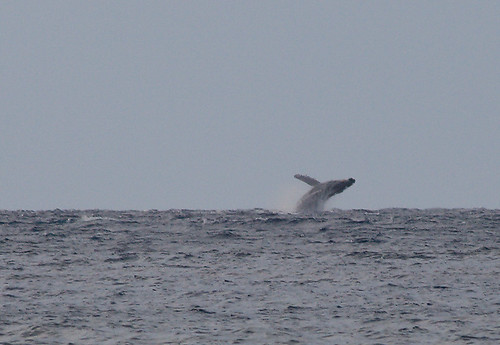
Magnificent!
Photo Credit: Tim Mckenna
A high pressure ridge remains over the Kauai end of the island chain Wednesday evening, with light winds…gradually becoming light trade winds Thursday. The Hawaiian Islands found light and variable breezes blowing Wednesday, with daytime sea breezes near the beaches. There continues to be a slight drift of air coming up from the southeast direction, which is keeping the volcanic haze in place locally. The trade winds will return briefly Thursday into Friday…then shift back to the southeast, as a cold front moves by north of Aloha state this weekend.
A dry and stable atmosphere will keep precipitation to a bare minimum, with almost everywhere remaining rain free for the time being. Despite the dry atmospherics, there will be afternoon convective cumulus clouds over and around the mountains, although they won’t give more than a few sprinkles at best. Light trade winds will return Thursday, bringing a few passing showers over the windward sides. We’ll find a convective weather pattern taking over this weekend, with modestly increased afternoon showers over the interior sections then, leaving the beaches alone for the most part.
It’s Wednesday evening as I begin updating this last paragraph of today’s narrative. Temperatures rose quickly statewide Wednesday, as the sun climbed higher into the sky. The high temperature rose all the way up to a very warm 86F degrees at Hilo, on the Big Island! This daytime heating caused cumulus cloud to grow around the mountains, aided by the sea breezes that developed locally. Those convective clouds weren’t rainfall producers however, although they looked like they should have cut loose at times. Besides the few showers that may be carried our way by the returning light trade winds Thursday, the next chance for slightly more precipitation will wait until this weekend. The atmosphere will be modestly more shower prone then, as an upper trough of low pressure moves overhead. Those showers will fall primarily over and around the mountains during the afternoon hours, leaving the beaches quite sunny in contrast…at least during the morning hours. ~~~ It appears that the weather here in Hawaii will continue to be just fine, with no major curve balls coming our way for the time being. Wednesday turned out to be a decent day, that is if one could put up with the thick volcanic haze that hung over the Kona area on the Big Island…extending up over the islands of Maui County as well. ~~~ I’ll be back very early Thursday morning with your next new weather narrative from paradise, I hope you have a great Wednesday night until then! Aloha for now…Glenn.
Interesting: While we continue to fixate on our little local worries, the biggest news story of the year passed unnoticed in the night. The Brazilian government was forced to admit that the destruction of the Amazon rainforest has returned to ecocidal levels. An area the size of Belgium, taking thousands of years to evolve, was destroyed in the past year alone. Some 20 per cent of the forest has now been trashed, with a further 40 per cent set to be slashed in our lifetime. This is steadily happening to all the rainforests on earth. The rainforests with the Amazon by far the largest are the planet’s air conditioner. They suck up millions of tons of greenhouse gases and store them safely out of the atmosphere. But as we hack them down, they are releasing these warming gases. Soon, we will reach a point where there is so much carbon in the atmosphere that the system will pack in and stop extracting anything at all. We will all feel the heat. It is a stark scientific fact that the last time the world warmed by 6C the upper-end of the UN scientists’ predictions for this century so quickly, almost everything on Earth died.
Interesting2: Like a finely tuned harp, the whiskers on a rat’s snout pick up particular frequencies and send these teensy signals to the brain. Now scientists have caught the whisker signals on video. With poor eyesight, rats must rely on their whiskers to navigate dark, dismal sewers and other underground haunts. Past research has shown that like harp strings, the shorter whiskers positioned at the front of rats’ snouts are tuned to vibrate at higher frequencies and the longer ones at lower frequencies. These signals get sent to rodents’ brains, where a large portion of their brain cells are devoted to decoding incoming whisker signals, making rats the super-sensors of the slum world. "They can sense the tiniest speck on a wall with their whiskers," said Christopher Moore of the McGovern Institute for Brain Research at MIT.
Interesting3: Pesticides, heavy metals and other airborne contaminants are raining down on national parks across the West and Alaska, turning up at sometimes dangerously high levels in lakes, plants and fish. A sweeping, six-year federal study released Tuesday found evidence of 70 contaminants in 20 national parks and monuments — from Denali in Alaska and Glacier in Montana, to Big Bend in Texas and Yosemite in California.
The findings revealed that some of the Earth’s most pristine wilderness is still within reach of the toxic byproducts of the industrial age.
"Contaminants are everywhere. You can’t get more remote than these northern parts of Alaska and the high Rockies,” said Michael Kent, a fish researcher with Oregon State University who co-authored the study.
Posted by Glenn
[2] Comments
February 26-27 2008
Air Temperatures – The following maximum temperatures were recorded across the state of Hawaii Tuesday:
Lihue, Kauai – 78
Honolulu, Oahu – 79
Kaneohe, Oahu – 76
Kahului, Maui – 78
Hilo, Hawaii – 80
Kailua-Kona, Hawaii – 82
Temperatures ranged between these warmest and coolest spots near sea level at 4 a.m. Tuesday morning:
Kailua-kona – 70F
Kahului, Maui – 56
Precipitation Totals – The following numbers represent the largest precipitation totals (inches) during the last 24 hours on each of the major islands, as of Tuesday afternoon:
0.01 MOLOAA DAIRY, KAUAI
0.02 DILLINGHAM, OAHU
0.00 MOLOKAI
0.00 LANAI
0.00 KAHOOLAWE
0.65 OHEO GULCH, MAUI
1.81 LAUPAHOEHOE, BIG ISLAND
Weather Chart – Here’s the latest (automatically updated) weather map. A high pressure ridge extends southwest, to over the islands…from a far away high pressure center to the NE. Light and variable winds will exist Wednesday, becoming trade winds as a new high rolls into focus to our NW Thursday.
Satellite and Radar Images: To view the cloud conditions we have here in Hawaii, please use the following satellite links, starting off with the Infrared Satellite Image of the islands to see all the clouds around the state during the day and night. This next image is one that gives close images of the islands only during the daytime hours, and is referred to as a Close-up visible image. This next image shows a larger view of the Pacific…giving perspective to the wider ranging cloud patterns in the Pacific Ocean…out from the islands. To help you keep track of where any showers may be around the islands, here’s the latest animated radar image.
Hawaii’s Mountains – Here’s a link to the live webcam on the summit of near 14,000 foot Mauna Kea on the Big Island of Hawaii. The tallest peak on the island of Maui is the Haleakala Crater, which is near 10,000 feet in elevation. These two webcams are available during the daylight hours here in the islands…and when there’s a big moon rising just after sunset for an hour or two! Plus, during the nights and early mornings you will be able to see stars, and the sunrise too…depending upon cloud conditions.
Aloha Paragraphs

Lovely Hula Hands
Photo Credit: flickr.com
Light and variable winds will remain in place through Wednesday, with trade winds expected Thursday into Friday…becoming kona winds from the south again this weekend. The Hawaiian Islands will find light and variable breezes blowing Wednesday, with daytime sea breezes near the beaches. There may be a slight drift of air coming up from the southeast direction, which will bring volcanic haze to some parts of the islands for a couple of days. The trade winds will return briefly Thursday into Friday…then shift back to the southeast and south, ahead of another cold front approaching the Aloha state this weekend.
Dry air remains in place the Hawaiian Islands behind the recent cold front, keeping rainfall to a minimum, and sunshine to a maximum along the beaches through Wednesday. Despite the dry atmospherics, there will be afternoon convective cumulus clouds over and around the mountains, although for the most part, they won’t drop many showers. The trade winds will return to some degree starting Thursday, bringing a few passing showers over the windward sides. We should see a fairly dry weekend coming up, as a cold front, that will be approaching then, stalls before arriving into our area. The computer models show good weather continuing into the first part of next week.
It’s Tuesday evening as I begin updating this last paragraph of today’s narrative. As you may gather, if you had a chance to read down through the two paragraphs above, our local Hawaiian Island weather picture will remain quite nice through the rest of this week. I should add that that will be a true statement if the computer models are providing the correct feedback in regards to the cold front that will be approaching the state fvrom the NW this weekend. I may have to do some revising along the way, especially in regards to this weekend, if that cold front doesn’t decide to stall…sneaking into the Kauai end of the state. Otherwise, I think that we’re in fine shape, with nothing too much more than a few windward showers, and a couple over and around the mountains through the rest of the week. The one wild card could be some showers moving into our area on the kona winds, especially along the leeward sides later this weekend into early next week. ~~~ Tuesday was a really nice day here in the islands, the one exception being a few showers in some places around the Big Island. Here on Maui, it was a great day, with lots of warm sunshine beaming down. Skies become a little cloudy around the edges during the afternoon hours, but I didn’t spot any showers falling. The air isn’t all that clear however, in terms of the haze that has been accumulating the last couple of days. The haze hasn’t gotten to the point where I would call it exactly thick, but then again, it is a long ways from perfectly clear either. ~~~ I’ll be back very early Wednesday morning with your next new weather narrative, I hope you have an excellent Tuesday night wherever you may be spending it! Aloha for now…Glenn.
Interesting: A "doomsday" seed vault built to protect millions of food crops from climate change, wars and natural disasters opened Tuesday deep within an Arctic mountain in the remote Norwegian archipelago of Svalbard.
"The Svalbard Global Seed Vault is our insurance policy," Norway’s Prime Minister Jens Stoltenberg told delegates at the opening ceremony. "It is the Noah’s Ark for securing biological diversity for future generations."
European Commission President Jose Manuel Barroso and 2004 Nobel Peace Prize winner Wangari Maathai of Kenya were among the dozens of guests who had bundled up for the ceremony inside the vault, about 425 feet deep inside a frozen mountain.
The vault will serve as a backup for hundreds of other seed banks worldwide. It has the capacity to store 4.5 million seed samples from around the world and shield them from man-made and natural disasters.
Dug into the permafrost of the mountain, it has been built to withstand an earthquake or a nuclear strike.
Interesting2: The fault line that spawned the 2004 Indian Ocean tsunami has ruptured nearly 20 times this month, causing three strong earthquakes. The activity shows the stress the seam is under and could be a harbinger of worse to come, scientists warn. Kerry Sieh, from the California Institute of Technology, has studied the fault for more than 10 years. He likened it to a length of rope in an imaginary tug of war between a group of men and an elephant. "One by one, two by two, the men are getting worn out and are letting go of the rope. That puts more stress on each of the remaining men," he wrote in an e-mail Tuesday. "Who knows which one will let go next, or whether they will let go all at once?" Sieh and other scientists using Global Positioning System transmitters to measure the uplift of the quakes say another massive temblor sometime in the next 100 years or so is likely, but they cannot predict exactly when that will occur.
Interesting3: While Sweden’s meteorologists are claiming that spring has arrived early across the country, they have yet to decide whether winter actually began. And as February draws to a close it looks like winter 2007-2008 will be Sweden’s mildest on record. The Swedish Meteorological and Hydrological Institute (SMHI) has two rules of thumb it has devised over the years to determine the arrival of winter and spring. For winter it is when the average temperature falls below freezing for five consecutive days. As yet that has not happened in southern Sweden. In fact January 2008 was the mildest on record for the country and at present temperatures through February have been 4 to 7 degrees above normal.
Posted by Glenn
No Comments
February 25-26 2008
Air Temperatures – The following maximum temperatures were recorded across the state of Hawaii Monday:
Lihue, Kauai – 79
Honolulu, Oahu – 83
Kaneohe, Oahu – 77
Kahului, Maui – 76
Hilo, Hawaii – 82
Kailua-Kona, Hawaii – 80
Temperatures ranged between these warmest and coolest spots near sea level at 4 a.m. Monday morning:
Honolulu, Oahu – 71F
Lihue, Kauai – 64
Precipitation Totals – The following numbers represent the largest precipitation totals (inches) during the last 24 hours on each of the major islands, as of Monday afternoon:
0.30 PORT ALLEN, KAUAI
0.93 LUALUALEI, OAHU
0.35 MOLOKAI
0.49 LANAI
0.32 KAHOOLAWE
1.62 OHEO GULCH, MAUI
0.25 HONOKAA, BIG ISLAND
Weather Chart – Here’s the latest (automatically updated) weather map. A new high pressure system will set up shop just to the north of Hawaii through Wednesday. This will cause light and variable winds across the islands.
Satellite and Radar Images: To view the cloud conditions we have here in Hawaii, please use the following satellite links, starting off with the Infrared Satellite Image of the islands to see all the clouds around the state during the day and night. This next image is one that gives close images of the islands only during the daytime hours, and is referred to as a Close-up visible image. This next image shows a larger view of the Pacific…giving perspective to the wider ranging cloud patterns in the Pacific Ocean…out from the islands. To help you keep track of where any showers may be around the islands, here’s the latest animated radar image.
Hawaii’s Mountains – Here’s a link to the live webcam on the summit of near 14,000 foot Mauna Kea on the Big Island of Hawaii. The tallest peak on the island of Maui is the Haleakala Crater, which is near 10,000 feet in elevation. These two webcams are available during the daylight hours here in the islands…and when there’s a big moon rising just after sunset for an hour or two! Plus, during the nights and early mornings you will be able to see stars, and the sunrise too…depending upon cloud conditions.
Aloha Paragraphs
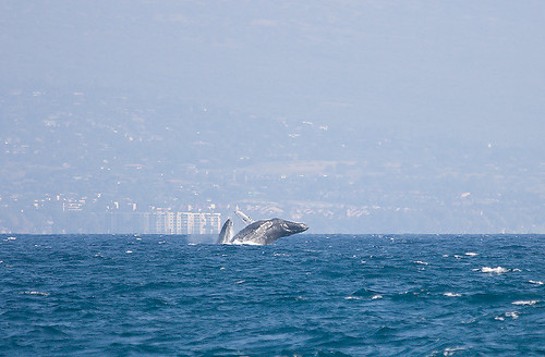
Humpback Whales breaching offshore from Maui
Photo Credit: flickr.com
A brief period of cool north to northeast breezes have filled in behind a dissipating cold front Monday evening…gradually becoming light and variable Tuesday. The Hawaiian Islands will find light and variable breezes blowing Tuesday and Wednesday. There may be a slight drift of air coming up from the southeast direction, which could bring volcanic haze to some parts of the islands again for a couple of days. The trade winds will return briefly Thursday into Friday…although the latest model runs now show the winds going light again from the southeast and south, ahead of another cold front approaching the Aloha state late next weekend.
A weakening cold front continues to move southeast across the southern islands, with partly cloudy skies…and a few showers. The front will continue its passage down over the Big Island Monday evening into the night. Clearing will occurred over Kauai and Oahu during the day…although stable clouds are riding in on the north breezes. Looking ahead , there will be afternoon convective clouds over and around the mountains, not many showers though. Trade wind showers will take over the windward sides Thursday into Friday with a few windward showers. We should see a fairly dry weekend coming up, as a cold front passes by to the north of the islands.
It’s Monday evening as I begin updating this last paragraph of today’s narrative. The dissipating front has passed by Maui County Monday, and as this satellite image shows, some leftover clouds are hung up over the Big Island. There are a few clouds extending back over the windward side of Maui as well. Tuesday and Wednesday will find mostly clear to partly cloudy mornings, giving way to afternoon cloudy periods, with a few showers falling over the upcountry areas. The atmosphere will remain dry and stable however, so that not many showers will fall from whatever clouds that around then. As we move into later Thursday and Friday, the trade winds will return briefly, with the bias for showers shifting back over to the windward sides. ~~~ I’ll be back very early Tuesday morning with your next new weather narrative. I hope you have a great Monday night until then! Aloha for now…Glenn.
Interesting: Whale watchers counted a record number of humpback whales off Maui this weekend. Volunteers at the annual count organized by the Pacific Whale Foundation tally whale sightings and record whale behaviors from 12 shoreline observation stations. Saturday’s count of 1,726 humpback whale sightings broke the 2006 record of 1,265.
The National Oceanic and Atmospheric Administration organizes counts on other islands. More than 700 volunteers from around the state took part at 57 sites. Flat seas, a mild breeze and clear skies helped whale watchers do their job on Kauai. Crater Hill had the most sightings of any of the 15 Kauai observation stations. A dozen whales were spotted there during a 15-minute reporting period between 8 a.m. and noon.
Interesting2: The West has become 500 percent dustier in the past two centuries due to westward U.S. expansion and accompanying human activity beginning in the 1800s, according to a new study led by the University of Colorado at Boulder. Sediment records from dust blown into alpine lakes in southwest Colorado‘s San Juan Mountains over millennia indicates the sharp rise in dust deposits coincided with railroad, ranching and livestock activity in the middle of the last century, said geological sciences Assistant Professor Jason Neff, lead author on the study. The results have implications ranging from ecosystem alteration to human health, he said.
"From about 1860 to 1900, the dust deposition rates shot up so high that we initially thought there was a mistake in our data," said Neff. "But the evidence clearly shows the western U.S. had it’s own Dust Bowl beginning in the 1800s when the railroads went in and cattle and sheep were introduced into the rangelands." A paper on the research funded by the Andrew W. Mellon Foundation was published in the Feb. 24 issue of Nature Geoscience. Co-authors included CU-Boulder’s Ashley Ballantyne, Lang Farmer and Corey Lawrence, Cornell University‘s Natalie Mahowald, the University of Arizona‘s Jessica Conroy and Jonathan Overpeck, Christopher Landry of the Center of Snow and Avalanche Studies in Silverton, Colo., the University of Utah‘s Tom Painter and the U.S. Geological Survey’s Richard Reynolds.
Interesting3: A new coating for solar panels could lead to more efficient solar collection. The energy from sunlight falling on only 9 percent of California’s Mojave Desert could power all of the United States’ electricity needs if the energy could be efficiently harvested, according to some estimates. Unfortunately, current-generation solar cell technologies are too expensive and inefficient for wide-scale commercial applications. A team of Northwestern University researchers has developed a new anode coating strategy that significantly enhances the efficiency of solar energy power conversion.
A paper about the work, which focuses on “engineering” organic material-electrode interfaces in bulk-heterojunction organic solar cells, is published online this week in the Proceedings of the National Academy of Sciences (PNAS). This breakthrough in solar energy conversion promises to bring researchers and developers worldwide closer to the goal of producing cheaper, more manufacturable and more easily implemented solar cells. Such technology would greatly reduce our dependence on burning fossil fuels for electricity production as well as reduce the combustion product: carbon dioxide, a global warming greenhouse gas.
Posted by Glenn
No Comments
February 24-25 2008
Air Temperatures – The following maximum temperatures were recorded across the state of Hawaii Sunday:
Lihue, Kauai – 78
Honolulu, Oahu – 81
Kaneohe, Oahu – 76
Kahului, Maui – 81
Hilo, Hawaii – 81
Kailua-Kona, Hawaii – 82
Temperatures ranged between these warmest and coolest spots near sea level at 6 a.m. Sunday morning:
Honolulu, Oahu – 76F
Hilo, Hawaii – 63
Precipitation Totals – The following numbers represent the largest precipitation totals (inches) during the last 24 hours on each of the major islands, as of Sunday afternoon:
1.28 MAKAHA RIDGE, KAUAI
1.06 PALOLO FIRE STATION, OAHU
0.10 MOLOKAI
0.22 LANAI
0.00 KAHOOLAWE
0.01 PUU KUKUI, MAUI
0.01 KAMUELA, BIG ISLAND
Weather Chart – Here’s the latest (automatically updated) weather map. A high pressure ridge extending west from a high pressure system northeast of Hawaii…is now to the SE and east of Hawaii. This ridge has been pushed there by a cold front. Winds will be locally brisk south kona winds ahead of the cold front, turning cooler and from the north briefly behind the front…lighter Tuesday.
Satellite and Radar Images: To view the cloud conditions we have here in Hawaii, please use the following satellite links, starting off with the Infrared Satellite Image of the islands to see all the clouds around the state during the day and night. This next image is one that gives close images of the islands only during the daytime hours, and is referred to as a Close-up visible image. This next image shows a larger view of the Pacific…giving perspective to the wider ranging cloud patterns in the Pacific Ocean…out from the islands. To help you keep track of where any showers may be around the islands, here’s the latest animated radar image.
Hawaii’s Mountains – Here’s a link to the live webcam on the summit of near 14,000 foot Mauna Kea on the Big Island of Hawaii. The tallest peak on the island of Maui is the Haleakala Crater, which is near 10,000 feet in elevation. These two webcams are available during the daylight hours here in the islands…and when there’s a big moon rising just after sunset for an hour or two! Plus, during the nights and early mornings you will be able to see stars, and the sunrise too…depending upon cloud conditions.
Aloha Paragraphs
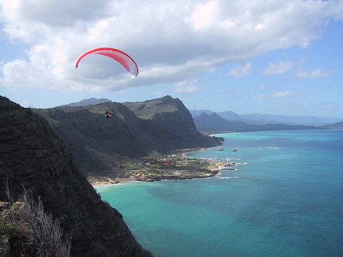
Gliding over the east side of Oahu
Photo Credit: flickr.com
We’ll find locally breezy south kona winds blowing ahead of a dissipating cold front pushing down through the state through Monday…followed by a brief period of cool north winds. There are no advisories or warnings with this brief period of kona winds, although it will become gusty in places. The winds will return to the light and variable category again Tuesday through Thursday. The trade winds will return Friday briefly. The latest computer forecast models show another cold front approaching the state next weekend, with southeast to southwest winds blowing again then.
A showery cold front will finally break the long lasting dry spell. This frontal passage will bring a few heavy showers…most notably on Kauai and Oahu. The bulk of these showers will fall along the windward sides. Looking ahead into the new week ahead, there will be some form of afternoon convective showers over and around the mountains. Additionally, there will be a good chance of more volcanic haze, as the air will be drifting up from the southeast direction during the middle of the week.
It’s Sunday evening as I begin updating this last paragraph of today’s narrative. The well advertised cold front will take until Monday to travel all the way through the entire island chain. This 250 mile wide frontal cloud band moved over the islands of Kauai and Oahu during the day. At the current rate of travel, which is running between 10-15 mph, it will arrive over the islands of Maui County during the late afternoon into the evening hours, where it may briefly stall overnight. The Big Island will have to wait until Monday morning for its share of showers, although by then it may be "running a little low on fuel." Here’s a looping satellite image so you can monitor this weather feature as its clouds move southeast deeper into the tropics. Since there will be precipitation moving through the state along and ahead of this frontal boundary, here’s a looping radar image so you can see where those showers are located. ~~~ I’ve had fun monitoring this cold front Sunday, despite the fact that it isn’t a very powerful one…although it’s the only game in town now. Here on Maui, skies have been partly cloudy for the most part, with a few showers here and there. At the time of this writing, the leading edge of this front was just knocking on the front door of Molokai. The back edge was still overlapping the island of Kauai, with clearing slowing occurring from the west into Monday. ~~~ I’m about ready to go down and start my dinner, which will end up being my dinners through most of the upcoming work week. I just popped a Sierra Nevada Pale Ale, sipping on that tasty brew while I tap out these last few words. At any rate, I sauteed a red onion, yukon yellow potatoes, mushrooms, carrots, green beans, garlic, and a can of corn (all organic of course), to make a nice pot of soup. I’ll ladle that delicious concoction into a medium size bowl, spooning it out with some of my favorite cheese, a Rouge et Noir Camembert, made by the Marin French Cheese Company in Petaluma, California, with crackers. It’s so nice to get home after a long day of weather work, just heat up the soup, which my Mom always says tastes better each day after cooking. ~~~ Kden as we say here in the islands, which simply means ok then, that’s about all I have for today. I’ll be back very early Monday morning with your next new weather narrative. I hope you have a great Sunday night wherever you happen to be reading from! Aloha for now…Glenn.
Very cool: http://www.tropicalglen.com/ it’s a Jukebox music website, that you can play all your favorite songs from the past…it will bring back many good memories!
Posted by Glenn
[5] Comments
February 23-24 2008
Air Temperatures – The following maximum temperatures were recorded across the state of Hawaii Saturday:
Lihue, Kauai – 81
Honolulu, Oahu – 81
Kaneohe, Oahu – 79
Kahului, Maui – 79
Hilo, Hawaii – 81
Kailua-Kona, Hawaii – 81
Temperatures ranged between these warmest and coolest spots near sea level at 6 a.m. Saturday morning:
Kailua-kona – 68F
Kahului, Maui – 57
Precipitation Totals – The following numbers represent the largest precipitation totals (inches) during the last 24 hours on each of the major islands, as of Saturday afternoon:
0.01 MOLOAA DAIRY, KAUAI
0.02 DILLINGHAM, OAHU
0.00 MOLOKAI
0.00 LANAI
0.00 KAHOOLAWE
0.00 MAUI
0.01 KAHUA RANCH, BIG ISLAND
Weather Chart – Here’s the latest (automatically updated) weather map. A high pressure ridge extending west from a high pressure system northeast of Hawaii…is located over Maui County. This ridge will be pushed to the south and east ahead of a cold front later Sunday into Monday. Winds will become brisk south kona winds ahead of the cold front, turning cooler and from the north behind the front.
Satellite and Radar Images: To view the cloud conditions we have here in Hawaii, please use the following satellite links, starting off with the Infrared Satellite Image of the islands to see all the clouds around the state during the day and night. This next image is one that gives close images of the islands only during the daytime hours, and is referred to as a Close-up visible image. This next image shows a larger view of the Pacific…giving perspective to the wider ranging cloud patterns in the Pacific Ocean…out from the islands. To help you keep track of where any showers may be around the islands, here’s the latest animated radar image.
Hawaii’s Mountains – Here’s a link to the live webcam on the summit of near 14,000 foot Mauna Kea on the Big Island of Hawaii. The tallest peak on the island of Maui is the Haleakala Crater, which is near 10,000 feet in elevation. These two webcams are available during the daylight hours here in the islands…and when there’s a big moon rising just after sunset for an hour or two! Plus, during the nights and early mornings you will be able to see stars, and the sunrise too…depending upon cloud conditions.
Aloha Paragraphs
Gliding over the east side of Oahu
Photo Credit: flickr.com
We’ll find locally breezy south kona winds beginning to blow later Saturday into Sunday, ahead of an active Pacific cold front arriving later Sunday into Monday…followed by a brief period of cool north winds. The winds will return to the light and variable category again Tuesday through Thursday. The trade winds will finally return by Friday…lasting through next weekend. Trade winds often bring the good chance of occasional passing showers along the windward coasts and slopes…leaving the leeward sides mostly dry.
The exceptionally dry conditions will keep whatever few showers that happen to occur, to a bare minimum at best. A showery cold front, arriving later Sunday into Monday will finally break the long lasting dry spell. This frontal passage won’t bring too much heavy rain…with most of the showers falling over the windward sides of the islands. There may be a few showers spreading over to the leeward sides locally. Looking ahead into the new week ahead, there will be some form of afternoon convective showers over and around the mountains…with the good chance of more volcanic haze.
It’s Saturday evening as I begin updating this last paragraph of today’s narrative. This well advertised cold front, which will arrive later Sunday, will take until later Monday to travel down through the entire island chain. It will arrive over Kauai and Oahu Sunday, during the evening hours on Maui…and finally on Monday for the Big Island. Here’s a looping satellite image so you can keep an eye on this approaching weather feature. ~~~ I saw the new film called Vantage Point (2008), starring William Hurt, Dennis Quaid, Sigourney Weaver, and Matthew Fox Friday evening after work. This film shows eight strangers, with eight different points of view, trying to unlock the one truth behind an assassination attempt on the president of the United States. The critics aren’t in love with this film, giving it grades ranging between C and B. As usual, I was in the mood for getting back to the theater, sitting with all those strangers in the dark…getting moved into a totally different reality. As I almost always have to say here, this certainly isn’t the kind of film that many people would be drawn to, and even watching the trailer might be a bit too much! If you’re so inclined however, here’s the trailer for this dramatic thriller. I actually enjoyed the film quite a bit, and as usual, just got swept away with all the fast paced action. It was an intense piece of work, no doubt about that…which somehow appeals to me. ~~~ I got a call from the Kula Hardware store yesterday, telling me that an order I had made last year was finally in. I ordered a few plants called Cyclamens, which are great for growing indoors. I always like to have a nice house plant to nurture, it becomes like a new friend. I went down and picked them up during the afternoon, and was happy with both healthy plants. ~~~ Saturday started off in the most beautiful way, with clear skies, and just a bit of haze. The haze thickened during the day however, and so did the clouds that formed over and around the mountains. The atmosphere remained so dry though, that no rain fell anywhere. I’ll be back Sunday morning with your next weather narrative. I hope you have a great Saturday night wherever you happen to be spending it! Aloha for now…Glenn.
Posted by Glenn
No Comments
February 22-23 2008
Air Temperatures – The following maximum temperatures were recorded across the state of Hawaii Friday:
Lihue, Kauai – 79
Honolulu, Oahu – 80
Kaneohe, Oahu – 79
Kahului, Maui – 77
Hilo, Hawaii – 82
Kailua-Kona, Hawaii – 81
Temperatures ranged between these warmest and coolest spots near sea level at 4 a.m. Friday morning:
Barking Sands, Kauai – 68F
Kahului, Maui – 58
Precipitation Totals – The following numbers represent the largest precipitation totals (inches) during the last 24 hours on each of the major islands, as of Friday afternoon:
0.03 MOLOAA DAIRY, KAUAI
0.01 WHEELER AIRFIELD, OAHU
0.00 MOLOKAI
0.01 LANAI
0.00 KAHOOLAWE
0.00 MAUI
0.00 BIG ISLAND
Weather Chart – Here’s the latest (automatically updated) weather map. A high pressure ridge extending west from a small high pressure system just to the east-northeast of Hawaii…is now back down over Maui County. This pressure configuration will cause light winds across the state into Saturday. Here’s a Weather Map Symbol page for clarification about what all those weather symbols mean on the map.
Satellite and Radar Images: To view the cloud conditions we have here in Hawaii, please use the following satellite links, starting off with the Infrared Satellite Image of the islands to see all the clouds around the state during the day and night. This next image is one that gives close images of the islands only during the daytime hours, and is referred to as a Close-up visible image. This next image shows a larger view of the Pacific…giving perspective to the wider ranging cloud patterns in the Pacific Ocean…out from the islands. To help you keep track of where any showers may be around the islands, here’s the latest animated radar image.
Hawaii’s Mountains – Here’s a link to the live webcam on the summit of near 14,000 foot Mauna Kea on the Big Island of Hawaii. The tallest peak on the island of Maui is the Haleakala Crater, which is near 10,000 feet in elevation. These two webcams are available during the daylight hours here in the islands…and when there’s a big moon rising just after sunset for an hour or two! Plus, during the nights and early mornings you will be able to see stars, and the sunrise too…depending upon cloud conditions.
Aloha Paragraphs
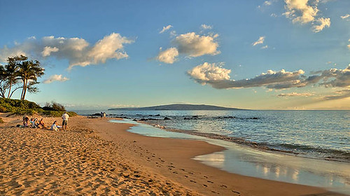
Late afternoon…Wailea, Maui
Photo Credit: flickr.com
This week’s light wind regime will carry into Saturday, picking up some Sunday from the south. Saturday the winds will remain in the light and variable category, as the high pressure ridge has dropped down over Maui County again. We’ll find locally breezy south kona winds arriving Sunday, associated with a weakening cold front arriving Sunday into Monday…followed by another round of light winds. We may see some form of light south to southwest winds develop as another cold front approaches the state around the middle of the new week ahead. The trade winds will finally return after that next weak cold front moves through the state around next Thursday…lasting into the weekend.
The long lasting dry spell will hold through Saturday, with more good weather on tap. Saturday morning will start off mostly clear, and generally end up that same way in most areas. The exceptionally dry conditions will keep whatever few showers that happen to occur, to a bare minimum at best…with most areas remaining totally dry. The computer models continue to show a modestly showery cold front arriving later Sunday into Monday, followed by more dry weather as we move into the first several days of the new week. This frontal passage isn’t expected to bring heavy rain with it by any means, and most of whatever showers that do arrive, will fall over the windward sides of the islands at that.
It’s Friday evening as I begin updating this last paragraph of today’s narrative. The only problem area that I can see here in the islands, in terms of the weather, is the rather heavy volcanic haze that covers parts of the Big Island. Here on Maui, it’s been hazy around the edges too. Our weather otherwise has been great, with most days this week continuing to be very dry, and with lots of sunshine beaming down. This week would have been a good week to work on any roof problems, or to get that big painting job done. It’s interesting how the weather is, as just recently, folks were complaining about how wet it was here in the islands, at least along the windward sides. Now, it has turned bone dry, with many areas, even those normally more showery windward areas…not experiencing one drop of rain for the better part of a week. ~~~ This cold front, which will arrive later this weekend, will take until later Monday to travel down through the island chain. It may however stall along the way, most likely over the central islands somewhere between Molokai and Maui? Then again, it may be able to find just enough strength to make it to the northern half of the Big Island, although perhaps barely. We can fine tune all of this as we get into the weekend, finally taking a look at its condition once it gets a little closer. Here’s a looping satellite image so you can start to keep an eye on this approaching weather feature. ~~~ I’ve decided to see the new film called Vantage Point (2008), starring William Hurt, Dennis Quaid, Sigourney Weaver, and Matthew Fox. This film is about eight strangers with eight different points of view try to unlock the one truth behind an assassination attempt on the president of the United States. The critics aren’t in love with this film, giving it grades ranging between C and B. As usual, I’m in the mood for getting back to the theater, sitting with all those strangers in the dark…getting carried away into a totally different reality. As I almost always have to say here, this certainly isn’t the kind of film that most people would be drawn to, and even watching the trailer might be a bit too much! If you’re so inclined however, here’s the trailer for this dramatic thriller. ~~~ I’ll be back early Saturday morning, not very early though, like I am during the weekdays…with your next weather narrative. I’ll also let you know what I thought of this new film then as well. I hope you have a great Friday night wherever you may be spending it! Aloha for now…Glenn.
Interesting: Gravity powered lamp generates as much light as 40 Watt bulb. Clay Moulton of Springfield, Va., who received his Master of Science in Architecture with a concentration in industrial design from the College of Architecture and Urban Studies in 2007, created the lamp as a part of this master’s thesis. The LED lamp, named Gravia, has just won second place in the Greener Gadgets Design Competition as part of the Greener Gadgets Conference in New York City.
Concept illustrations of Gravia depict an acrylic column a little over four feet high. The entire column glows when activated. The electricity is generated by the slow fall of a mass that spins a rotor. The resulting energy powers 10 high-output LEDs that fire into the acrylic lens, creating a diffuse light. The operation is silent and the housing is elegant and cord free — completely independent of electrical infrastructure.
Interesting2: A deadly combination of climate change, over-fishing and pollution could cause the collapse of commercial fish stocks worldwide within decades, said Achim Steiner, head of the United Nations Environment Program. "You overlap all of this and you see you’re potentially putting a death nail in the coffin of world fisheries," Steiner told reporters on Friday on the fringes of a climate conference involving more than 150 nations and 100 environment ministers. Some 2.6 billion people worldwide depend on fish for protein, said a UNEP report "In Dead Water" published on Friday. Climate change has compounded previous problems such as over-fishing, as rising temperatures kill coral reefs, threaten tuna spawning grounds, and shift ocean currents and with them the plankton and small fish which underpin ocean food chains.
The question is not whether we should stop fishing but to address climate change, which is creating a degree of impact we’ve not seen before," said lead author of the UNEP report, Christian Nellemann. "We are getting more and more alarming signals of dramatic changes in the oceans. The recovery from the changes we’re making will probably take a million years." The report found the most affected areas included those responsible for half the world’s fish catch. A slowing of ocean currents as a result of climate change may over the next 100 years interrupt the transport of nutrients to the most valuable coastal fishing zones, and the flushing away of pollution.
Glenn’s TV Weather show is back online now. One day’s show will replaced with the next new days show at around 930am HST (1130am PST – 230pm EST)…Monday through Friday. Thanks to the folks at the Maui Media Lab in Paia for making this happen! I was just informed that about 100 people a day are taking the time to watch the show, thanks for your viewership!
Posted by Glenn
No Comments
February 21-22 2008
Air Temperatures – The following maximum temperatures were recorded across the state of Hawaii Thursday:
Lihue, Kauai – 80
Honolulu, Oahu – 81
Kaneohe, Oahu – 79
Kahului, Maui – 79
Hilo, Hawaii – 82
Kailua-Kona, Hawaii – 81
Temperatures ranged between these warmest and coolest spots near sea level at 4 a.m. Thursday morning:
Kailua-kona – 73F
Kahului, Maui – 62
Precipitation Totals – The following numbers represent the largest precipitation totals (inches) during the last 24 hours on each of the major islands, as of Thursday afternoon:
0.00 WAILUA, KAUAI
0.01 PALOLO FIRE STATION, OAHU
0.00 MOLOKAI
0.00 LANAI
0.00 KAHOOLAWE
0.00 MAUI
0.01 KAHUA RANCH, BIG ISLAND
Weather Chart – Here’s the latest (automatically updated) weather map. A high pressure ridge extending west from a small high pressure system just to the east-northeast of Hawaii…is now back down over Maui County. This pressure configuration will cause light winds across the state into Saturday. Here’s a Weather Map Symbol page for clarification about what all those weather symbols mean on the map.
Satellite and Radar Images: To view the cloud conditions we have here in Hawaii, please use the following satellite links, starting off with the Infrared Satellite Image of the islands to see all the clouds around the state during the day and night. This next image is one that gives close images of the islands only during the daytime hours, and is referred to as a Close-up visible image. This next image shows a larger view of the Pacific…giving perspective to the wider ranging cloud patterns in the Pacific Ocean…out from the islands. To help you keep track of where any showers may be around the islands, here’s the latest animated radar image.
Hawaii’s Mountains – Here’s a link to the live webcam on the summit of near 14,000 foot Mauna Kea on the Big Island of Hawaii. The tallest peak on the island of Maui is the Haleakala Crater, which is near 10,000 feet in elevation. These two webcams are available during the daylight hours here in the islands…and when there’s a big moon rising just after sunset for an hour or two! Plus, during the nights and early mornings you will be able to see stars, and the sunrise too…depending upon cloud conditions.
Aloha Paragraphs
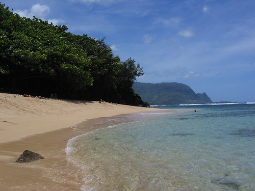
Hideaways Beach on Kauai
Photo Credit: flickr.com
Light winds in general, from varying directions, will continue into Saturday morning. We’ll find locally breezy south to southeast winds arriving later Saturday into Sunday, associated with an active cold front arriving later in the day Sunday into Monday…followed by cool north breezes after it passes through. Light trade winds will return again for a few days thereafter. We may see some form of light south to southwest winds develop as another cold front approaches the state around the middle of next week.
The overlying atmosphere is unusually dry and stable, with hardly a drop of water falling from the sky anywhere. The days will start off in a mostly clear way, and generally will end up that same way in most areas. The exceptionally dry conditions will keep whatever few showers that happen to break loose from these clouds, to a bare minimum at best…with most areas remaining totally dry. The computer models continue to show a showery cold front arriving later Sunday into Monday, followed by more dry weather as we move into the first several days of next week.
It’s Thursday evening as I begin updating this last paragraph of today’s narrative. Dry, dry, dry, that’s the name of the game here in the Hawaiian Islands now! 99.9% of all the rain gauges across the Aloha state remained dry as a bone during the last 24 hours. Actually, all this week has been very dry indeed. I see little change in this situation through Friday into Saturday. As we move through the day Saturday however, and as the kona winds develop ahead of Sunday’s cold front…we may see a few showers falling along the leeward coasts and slopes later in the day. We call this kind of precipitation, prefrontal showers, although with such dry atmospherics, they won’t amount to much. The main event, although that may be too dramatic a label for what will actually happen…will be the shower producing cold frontal passage later Sunday into Monday. This doesn’t look like too much of a big deal, with most of the showers sticking pretty closely to the windward sides of the islands from Kauai down through Maui. This quickly weakening frontal boundary may be mostly dissipated by the time it makes its way over the northern part of the Big Island Monday. This will be a brief affair, with more good weather on tap as we move into next week. The next possible chance of a cold front, with a brief period of showers, would arrive around next Thursday. ~~~ Thursday was another one of those mostly clear days here in Hawaii, with just a few thin clouds forming over the mountains during the afternoon hours. I happen to be in Kula, Maui, an upcountry area, and it’s definitely mostly clear just before sunset. There is some volcanic haze around, and I understand that the Big Island is having some thick vog down there! Thursday night will be a cool one, as there are so few clouds, remaining that way through the night. Friday will begin the same way that Thursday did, with mostly clear skies just about everywhere. ~~~ I’ll be back very early Friday morning with your next new weather narrative from paradise. I hope you have a great Thursday night, which will be well lit by the just past February full moon! Aloha for now…Glenn.
Interesting: An earthquake of 6.2 magnitude — the biggest in Norwegian history — jolted the thinly populated Svalbard archipelago in the Arctic on Wednesday night, the Norsar seismic research institute said on Thursday. No one was hurt by the quake and no damage has been reported in the islands, about 1,000 km (600 miles) from the North Pole, reports said. "This is the biggest earthquake on Norwegian territory in history," the institute said in a statement, adding that the quake occurred at sea, about 10 km (6 miles) below the surface. Anne-Karin Bekken, one of roughly 2,000 residents of the archipelago’s main town Longyearbyen, said she and her boyfriend were jolted awake by the earthquake. "We woke up and everything was shaking. It was a bit scary," she told Reuters over the telephone. "Before I realized what it was, it was over. I thought it was the blizzard blowing the house into pieces," said Bekken, a consultant at the local coal mine. Norsar said Svalbard registered several aftershocks, and predicted there would be more. Norwegian Prime Minister Jens Stoltenberg, European Commission President Jose Manuel Barroso and other leaders will be in Svalbard next week for the official opening of a seed vault which will store frozen crop seeds from around the world in case crops are wiped out by a future disaster.
Interesting2: Tiny particles of pure silica coated with an active material could be used to remove toxic chemicals, bacteria, viruses, and other hazardous materials from water much more effectively and at lower cost than conventional water purification methods, according to researchers writing in the current issue of the International Journal of Nanotechnology. Peter Majewski and Chiu Ping Chan of the Ian Wark Research Institute, at the University of South Australia, explain that the availability of drinking quality water is fast becoming a major socio-economic issue across the globe, especially in the developing world. However, water purification technology is often complicated, requires sophisticated equipment and is expensive to run and maintain. Moreover, it usually requires a final costly disinfection stage. The Australian team suggests that nanotechnology could provide a simple answer to the problem.
Glenn’s TV Weather show is back online now. One day’s show will replaced with the next new days show at around 930am HST (1130am PST – 230pm EST)…Monday through Friday. Thanks to the folks at the Maui Media Lab in Paia for making this happen! I was just informed that about 100 people a day are taking the time to watch the show, thanks for your viewership!
Posted by Glenn
No Comments
February 20-21 2008
Air Temperatures – The following maximum temperatures were recorded across the state of Hawaii Wednesday:
Lihue, Kauai – 79
Honolulu, Oahu – 81
Kaneohe, Oahu – 79
Kahului, Maui – 80
Hilo, Hawaii – 82
Kailua-Kona, Hawaii – 80
Temperatures ranged between these warmest and coolest spots near sea level at 4 a.m. Wednesday morning:
Kailua-kona – 70F
Kahului, Maui – 56 (record for the date: 54 degrees back in 1972)
Precipitation Totals – The following numbers represent the largest precipitation totals (inches) during the last 24 hours on each of the major islands, as of Wednesday afternoon:
0.01 WAILUA, KAUAI
0.03 DILLINGHAM, OAHU
0.00 MOLOKAI
0.01 LANAI
0.00 KAHOOLAWE
0.00 MAUI
0.01 KAPAPALA RANCH, BIG ISLAND
Weather Chart – Here’s the latest (automatically updated) weather map. A high pressure ridge extending west from a small high pressure system just to the east of Hawaii…is now just north of Kauai. This pressure configuration will cause light and variable winds, with daytime sea breezes, or light trade winds Thursday. The ridge will drop down over the state again Friday, keeping the winds light and variable. Here’s a Weather Map Symbol page for clarification about what all those weather symbols mean on the map.
Satellite and Radar Images: To view the cloud conditions we have here in Hawaii, please use the following satellite links, starting off with the Infrared Satellite Image of the islands to see all the clouds around the state during the day and night. This next image is one that gives close images of the islands only during the daytime hours, and is referred to as a Close-up visible image. This next image shows a larger view of the Pacific…giving perspective to the wider ranging cloud patterns in the Pacific Ocean…out from the islands. To help you keep track of where any showers may be around the islands, here’s the latest animated radar image.
Hawaii’s Mountains – Here’s a link to the live webcam on the summit of near 14,000 foot Mauna Kea on the Big Island of Hawaii. The tallest peak on the island of Maui is the Haleakala Crater, which is near 10,000 feet in elevation. These two webcams are available during the daylight hours here in the islands…and when there’s a big moon rising just after sunset for an hour or two! Plus, during the nights and early mornings you will be able to see stars, and the sunrise too…depending upon cloud conditions.
Aloha Paragraphs
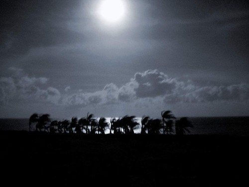
Full moon palms…the night sun
Photo Credit: flickr.com
Our local winds here in Hawaii will remain light and variable in direction through the work week…with trade winds reaching up over the Big Island at times. Storms in the middle latitudes of the north central Pacific, are keeping our trade wind producing high pressure ridge just to the north of the island of Kauai Wednesday night. Daytime sea breezes will occur near the beaches, followed by downslope land breezes during the nights. We’ll see brisk south to SW kona winds arriving later Saturday into Sunday, associated with an active cold front arriving Sunday into Monday…followed by cool north winds after it passes through. Light trade winds will return next Tuesday for a few days.
Exceptionally clear weather will continue, with a modest amount of afternoon clouds forming over and around the mountains during the late afternoons. Those relatively minor stratus and stratocumulus clouds will clear back at night, providing a good view of the full moon Wednesday evening here in the islands. The overlying atmosphere is unusually dry and stable at the moment. This will keep whatever showers that may fall in the upcountry areas very light and spotty at best. The computer models are showing a showery cold front arriving Sunday into Monday, followed by more dry weather as we move into the first several days of next week.
It’s Wednesday evening as I begin updating this last paragraph of today’s narrative. A light winded convective weather pattern remains in residence over the Hawaiian Islands now. Clear nights, with cooler than normal temperatures, will provide a near cloud free start to the days. As the sun gets higher in the sky, clouds will begin to form over and around the mountains later in the afternoon hours, although will be very limited in coverage. ~~~ As mentioned above, the Hawaiian Islands are enjoying a very dry period of weather, with the largest rainfall amount anywhere in the Aloha state a scant .03" during the last 24 hours…which is essentially nothing for Hawaii! The inversion layer over the islands is a very low 4,000 feet, which simply means that whatever few clouds that do form, will be very thin and not likely to drop any rain. ~~~ The next chance for an increase in showers will arrive later this weekend, as we finally see a cold front push down through the state of Hawaii Sunday into Monday. We haven’t had such a weather feature in a long time, not since well back in January. This will be a brief affair however, with cool north winds following closely in its wake…bringing more dry weather our way. ~~~ Wednesday evening at 5:31 HST will find the February full moon. For you astrology fans, it will be in the sign of Virgo. The late afternoon clouds will evaporate quickly this evening, clearing the way for great full moon viewing opportunities tonight! ~~~ Wednesday was almost an exact duplicate of Tuesday’s weather conditions. The few clouds that formed where few and far between, and remained benign in terms of precipitation. I anticipate that Thursday will be very similar to the last two days, with little change moving into Friday as well. As I’m fond of saying lately, this weather pattern is providing some of the best weather of winter 2008! I’ll be back very early Thursday morning, after a bright night of reflected sunlight off the full moon! I hope you have a great Wednesday night wherever you happen to be. Aloha for now…Glenn.
Interesting: Northern China is likely to be hit with more frequent and more severe sandstorms this year, Xinhua news agency reported on Wednesday, posing a challenge to Olympics organizers hoping for blue skies over Beijing. Sandstorms were forecast to increase this spring in the northern provinces of Inner Mongolia and Hebei, which surrounds Beijing, Xinhua said, citing the China Meteorological Administration. Eastern regions would be prone to drought, which could raise the risk of forest fires. Meteorologists said the adverse forecasts were related to the La Nina weather phenomenon. But decades of overgrazing and deforestation mean that China is also fighting to contain its deserts, whose spread has helped fuel the sandstorms that lash the country’s north every spring and whose effects are felt in South Korea and Japan. Beijing has pledged to hold a sandstorm-free Olympics come August, and has launched campaigns to restore denuded land and plant trees, with its noxious air quality a major concern for both athletes and organizers.
Interesting2: Not a square kilometer of the world’s oceans has been left untouched by human activities, a new study shows. Ocean ecosystems face a wide range of threats from human sources, including overfishing, pollution, and rising ocean temperatures and ocean acidification caused by global warming. An international team of scientists gathered global data for 17 different types of these human impacts and fed them into a model that produced a map of the world’s oceans with each square kilometer assigned a value of the level of impact at that particular spot. Their results are detailed in the Feb. 15 issue of the journal Science, and were presented today at the annual meeting of the American Association for the Advancement of Science in Boston. The map showed that human activities have to some degree affected all parts of the oceans, with 41 percent being strongly impacted by several human-caused drivers. "What is new today is that… we know how much of the oceans are in trouble and this figure is frighteningly high," said co-author Fiorenza Micheli, a Stanford University marine ecologist, at a news conference in Boston.
Total Lunar Eclipse
Glenn’s TV Weather show is back online now. One day’s show will replaced with the next new days show at around 9am HST (11am PST – 2pm EST)…Monday through Friday. Thanks to the folks at the Maui Media Lab in Paia for making this happen! I was just informed that about 100 people a day are taking the time to watch the show, thanks for your viewership!
Posted by Glenn
[3] Comments
February 19-20 2008
Air Temperatures – The following maximum temperatures were recorded across the state of Hawaii Tuesday:
Lihue, Kauai – 80
Honolulu, Oahu – 80
Kaneohe, Oahu – 80
Kahului, Maui – 79
Hilo, Hawaii – 83
Kailua-Kona, Hawaii – 80
Temperatures ranged between these warmest and coolest spots near sea level at 4 a.m. Tuesday morning:
Kailua-kona – 71F
Kahului, Maui – 58
Precipitation Totals – The following numbers represent the largest precipitation totals (inches) during the last 24 hours on each of the major islands, as of Tuesday afternoon:
0.01 MOLOAA DAIRY, KAUAI
0.02 MANOA LYON ARBORETUM, OAHU
0.00 MOLOKAI
0.00 LANAI
0.00 KAHOOLAWE
0.04 ULUPALAKUA, MAUI
0.03 WAIKII, BIG ISLAND
Weather Chart – Here’s the latest (automatically updated) weather map. A high pressure ridge extending southwest from a small high pressure system just to the east of Hawaii…is now over Kauai. This pressure configuration will cause light and variable winds, with daytime sea breezes through Thursday. Here’s a Weather Map Symbol page for clarification about what all those weather symbols mean on the map.
Satellite and Radar Images: To view the cloud conditions we have here in Hawaii, please use the following satellite links, starting off with the Infrared Satellite Image of the islands to see all the clouds around the state during the day and night. This next image is one that gives close images of the islands only during the daytime hours, and is referred to as a Close-up visible image. This next image shows a larger view of the Pacific…giving perspective to the wider ranging cloud patterns in the Pacific Ocean…out from the islands. To help you keep track of where any showers may be around the islands, here’s the latest animated radar image.
Hawaii’s Mountains – Here’s a link to the live webcam on the summit of near 14,000 foot Mauna Kea on the Big Island of Hawaii. The tallest peak on the island of Maui is the Haleakala Crater, which is near 10,000 feet in elevation. These two webcams are available during the daylight hours here in the islands…and when there’s a big moon rising just after sunset for an hour or two! Plus, during the nights and early mornings you will be able to see stars, and the sunrise too…depending upon cloud conditions.
Aloha Paragraphs
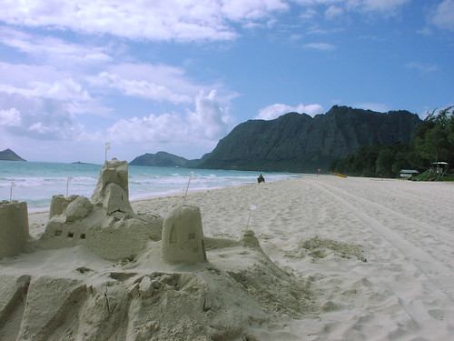
Sand Castles on the beach in Hawaii
Photo Credit: flickr.com
Light and variable winds will remain in place through the work week…with stronger south kona winds arriving later this weekend. Storms in the middle latitudes of the north central Pacific, are keeping our trade wind producing high pressure ridge down over the islands of Maui County Tuesday evening. Daytime sea breezes will blow near the beaches, followed by downslope land breezes during the nights. There remains the good chance of brisk southerly winds associated with an active cold front arriving Sunday…followed by cool north winds after it passes through into Monday.
This convective weather pattern will provide clear skies during the mornings, giving way to afternoon clouds over and around the mountains. The clouds will clear back at night, providing a good view of the upcoming full moon Wednesday evening here in the islands. As usual during a weather pattern such as this, the beaches will be the sunniest places. The overlying atmosphere is dry and stable from Kauai down through the Big Island. This will keep whatever showers that may fall in the upcountry areas light and spotty at best. The computer models are showing a showery cold front arriving Sunday into next Monday.
It’s Tuesday evening as I begin updating this last paragraph of today’s narrative. A well established convective weather pattern remains in place over the Hawaiian Islands now. Clear nights, with cooler than normal temperatures, will provide a near cloud free start to the mornings. As the sun gets higher in the sky, clouds will begin to form over and around the mountains, although for the most part, will be dry ones. ~~~ It’s looking more and more likely that an active Pacific cold front will push down through the state later this coming weekend into next Monday. If this frontal passage occurs as the computer models are suggesting, we would see breezy south kona winds arriving ahead of a showery cloud band, followed by brisk and cool north to northeast winds in the wake of its passage. ~~~ This week looks like a good one, although with light winds, and a fairly low inversion layer, we’ll see quite a bit of haze around the edges. As mentioned above, the nights and early mornings will be on the cool side, with the need for an extra blanket on the bed perhaps necessary, even right down at sea level. ~~~ Speaking of the nights, this month’s full moon will occur, at least here in the islands, early Wednesday evening. It has already been quite large and bright the last few nights, so that Tuesday night through Thursday nights will continue to see that moon really beaming down on us! ~~~ Tuesday turned out to be one of the sunniest days of the month so far. The mid afternoon hours finally saw some pretty light weight cumulus clouds congregating around the mountains. As has been the case the last few days, there will continue to be generally dry weather just about everywhere! I’ll be back very early Wednesday morning with your next new weather narrative from paradise. I hope you have a great Tuesday night wherever you happen to be spending it! Aloha for now…Glenn.
Interesting: An apparent meteor streaked through the sky over the Pacific Northwest early Tuesday, drawing reports of bright lights and sonic booms in parts of Washington, Oregon and Idaho.
Although a witness reported seeing the object strike the Earth in a remote part of Adams County, in southeast Washington, it had not been found.
"I’m convinced it was a meteor," said Geoff Chester, spokesman for the U.S. Naval Observatory in Washington, D.C. "It was a classic description of a fireball."
Chester speculated the meteor was the size of a big suitcase and had been orbiting the sun for millions of years before entering Earth’s orbit.
The Federal Aviation Administration said a private pilot reported seeing the meteor hit the Earth in a burst of light near State Route 26 and the Lind-Hatton Road about 5:45 a.m.
The Adams County sheriff’s office had no immediate reports of damage, injury or a meteor landing in the area, about 175 miles east-southeast of Seattle and 90 miles southwest of Spokane.
Chester said people commonly think they see a meteor hit or about to hit the ground, when it is nowhere close. Most meteorites that strike the Earth are never found, he said
"When you see objects like this in the sky your sense of scale is distorted," he said. "It’s a common optical illusion."
A number of pilots reported seeing the meteor streaking through the sky from Boise, Idaho, into Washington state, the FAA said.
Surveillance cameras in the region captured a ball of light in the sky and then a flash illuminating the early morning darkness.
Glenn’s TV Weather show is back online now. One day’s show will replaced with the next new days show at around 9am HST (11am PST – 2pm EST)…Monday through Friday. Thanks to the folks at the Maui Media Lab in Paia for making this happen!
Posted by Glenn
1 Comment
February 18-19 2008
Air Temperatures – The following maximum temperatures were recorded across the state of Hawaii Monday:
Lihue, Kauai – 81
Honolulu, Oahu – 80
Kaneohe, Oahu – 81
Kahului, Maui – 78
Hilo, Hawaii – 83
Kailua-Kona, Hawaii – 80
Temperatures ranged between these warmest and coolest spots near sea level at 6 a.m. Monday morning:
Honolulu, Oahu – 72F
Kahului, Maui – 60
Precipitation Totals – The following numbers represent the largest precipitation totals (inches) during the last 24 hours on each of the major islands, as of Monday afternoon:
0.01 MOUNT WAIALEALE, KAUAI
0.57 WAIANAE, OAHU
0.04 MOLOKAI
0.00 LANAI
0.00 KAHOOLAWE
0.94 KAUPO GAP, MAUI
0.10 POHAKULOA WEST, BIG ISLAND
Weather Chart – Here’s the latest (automatically updated) weather map. A high pressure ridge extending southwest from a high pressure system far NE of Hawaii…is now over Maui. This pressure configuration will cause light and variable winds, with daytime sea breezes through Wednesday. Here’s a Weather Map Symbol page for clarification about what all those weather symbols mean on the map.
Satellite and Radar Images: To view the cloud conditions we have here in Hawaii, please use the following satellite links, starting off with the Infrared Satellite Image of the islands to see all the clouds around the state during the day and night. This next image is one that gives close images of the islands only during the daytime hours, and is referred to as a Close-up visible image. This next image shows a larger view of the Pacific…giving perspective to the wider ranging cloud patterns in the Pacific Ocean…out from the islands. To help you keep track of where any showers may be around the islands, here’s the latest animated radar image.
Hawaii’s Mountains – Here’s a link to the live webcam on the summit of near 14,000 foot Mauna Kea on the Big Island of Hawaii. The tallest peak on the island of Maui is the Haleakala Crater, which is near 10,000 feet in elevation. These two webcams are available during the daylight hours here in the islands…and when there’s a big moon rising just after sunset for an hour or two! Plus, during the nights and early mornings you will be able to see stars, and the sunrise too…depending upon cloud conditions.
Aloha Paragraphs
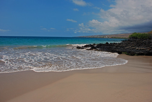
Lovely secluded Hawaiian beach
Photo Credit: flickr.com
Light winds from the south and SE, will give way to light trade winds…and then become stronger south kona winds by the weekend. Storms in the middle latitudes of the north central Pacific, are keeping our trade wind producing high pressure ridge down over the Big Island on this Presidents Day holiday. There will be light south to SE winds, gradually becoming light easterly trade winds starting Tuesday. Despite the variable directions of our winds this week, they will remain light in general. There remains the chance of windy southerly winds associated with an active cold front arriving this weekend.
We remain in a convective weather pattern Monday evening, with clear skies in the mornings giving way to increased clouds during the afternoons…with showers mostly over the interior sections. As usual during a weather pattern such as this, the beaches will be the sunniest places. When the trade winds return, albeit lightly on Tuesday, we may see a few showers, in addition to the afternoon inland showers…falling along the windward sides too. The computer models are showing a possible rainy weather event later this coming weekend.
It’s Monday evening as I begin updating this last paragraph of today’s narrative. Our high pressure ridge, which slipped just south of the Big Island Sunday, bringing increased moisture and clouds…has migrated northward over the state again. This essentially stopped the south winds, but kept a drift of air from the southeast over the islands. This puts us squarely back into a convective weather pattern, with clear cool mornings, becoming cloudy during the afternoon hours in the upcountry sections of each island. These clouds will drop some showers, although nothing heavy is indicated. ~~~ If you had a chance to read down through the two paragraphs above, you know that our weather here in the Aloha state will remain pretty similar from one day to the next through most of this week…with light trade winds returning soon. ~~~ The one change we see up ahead would occur this weekend…when we could finally see a vigorous Pacific cold front push down through the state Sunday. If this were to manifest as the computer models are insisting, we would see blustery south kona winds arriving ahead of a wet frontal cloud band, followed by brisk and cool north winds in the wake of its passage next Monday. ~~~ Sunday afternoon I drove over to the windward side here on Maui, to the lush area in Haiku. A good friend had a birthday party, with lots of friends attending, who are my friends as well. We had a good time, eating lots of delicious food, and having a few drinks. This persons husband is a music expert, and played all kinds of great tunes on his sound system. When we finished dinner, which we ate outside on the large deck, we went out onto the expansive lawn, and sat in chairs around a bonfire. It was a lovely evening, with the growing tropical moon shining brightly above. I finally got tired, although it was hard to leave the good conversations, along with the cake and ice cream…taking the drive back up the Haleakala Crater to Kula. Wow, a dance party Saturday night, and then another party Sunday night, that’s unusual for me. ~~~ Monday, because it was a holiday, allowed me to stay home, at least for the most part. I did have some house work to do, although I must admit, I didn’t sink into it quite as much as I thought I would. I took one of my cars to get some minor repairs, although fortunately my mechanic lives here in Kula, Maui. It got volcanically hazy as I expected this weekend, and cloudy this afternoon as well. There were a few light showers, but they didn’t amount to much as it turned out. ~~~ I’ll be back very early Tuesday morning with your next new weather narrative, I hope you have a lovely Monday night until then! Aloha for now…Glenn.
Glenn’s TV Weather show is back online again now. The colors aren’t perfect, although they are close enough. One day’s show will replaced with the next new days show at around 9am HST (11am PST – 2pm EST)…Monday through Friday. Thanks to the folks at the Maui Media Lab in Paia for making this happen!
« Previous Page — Next Page »


