


Hawaiian Islands weather details & Aloha paragraphs
Posted by GlennFebruary 20-21 2008
Air Temperatures – The following maximum temperatures were recorded across the state of Hawaii Wednesday:
Lihue, Kauai – 79
Honolulu, Oahu – 81
Kaneohe, Oahu – 79
Kahului, Maui – 80
Hilo, Hawaii – 82
Kailua-Kona, Hawaii – 80
Temperatures ranged between these warmest and coolest spots near sea level at 4 a.m. Wednesday morning:
Kailua-kona – 70F
Kahului, Maui – 56 (record for the date: 54 degrees back in 1972)
Precipitation Totals – The following numbers represent the largest precipitation totals (inches) during the last 24 hours on each of the major islands, as of Wednesday afternoon:
0.01 WAILUA, KAUAI
0.03 DILLINGHAM, OAHU
0.00 MOLOKAI
0.01 LANAI
0.00 KAHOOLAWE
0.00 MAUI
0.01 KAPAPALA RANCH, BIG ISLAND
Weather Chart – Here’s the latest (automatically updated) weather map. A high pressure ridge extending west from a small high pressure system just to the east of Hawaii…is now just north of Kauai. This pressure configuration will cause light and variable winds, with daytime sea breezes, or light trade winds Thursday. The ridge will drop down over the state again Friday, keeping the winds light and variable. Here’s a Weather Map Symbol page for clarification about what all those weather symbols mean on the map.
Satellite and Radar Images: To view the cloud conditions we have here in Hawaii, please use the following satellite links, starting off with the Infrared Satellite Image of the islands to see all the clouds around the state during the day and night. This next image is one that gives close images of the islands only during the daytime hours, and is referred to as a Close-up visible image. This next image shows a larger view of the Pacific…giving perspective to the wider ranging cloud patterns in the Pacific Ocean…out from the islands. To help you keep track of where any showers may be around the islands, here’s the latest animated radar image.
Hawaii’s Mountains – Here’s a link to the live webcam on the summit of near 14,000 foot Mauna Kea on the Big Island of Hawaii. The tallest peak on the island of Maui is the Haleakala Crater, which is near 10,000 feet in elevation. These two webcams are available during the daylight hours here in the islands…and when there’s a big moon rising just after sunset for an hour or two! Plus, during the nights and early mornings you will be able to see stars, and the sunrise too…depending upon cloud conditions.
Our local winds here in Hawaii will remain light and variable in direction through the work week…with trade winds reaching up over the Big Island at times. Storms in the middle latitudes of the north central Pacific, are keeping our trade wind producing high pressure ridge just to the north of the island of Kauai Wednesday night. Daytime sea breezes will occur near the beaches, followed by downslope land breezes during the nights. We’ll see brisk south to SW kona winds arriving later Saturday into Sunday, associated with an active cold front arriving Sunday into Monday…followed by cool north winds after it passes through. Light trade winds will return next Tuesday for a few days.
Exceptionally clear weather will continue, with a modest amount of afternoon clouds forming over and around the mountains during the late afternoons. Those relatively minor stratus and stratocumulus clouds will clear back at night, providing a good view of the full moon Wednesday evening here in the islands. The overlying atmosphere is unusually dry and stable at the moment. This will keep whatever showers that may fall in the upcountry areas very light and spotty at best. The computer models are showing a showery cold front arriving Sunday into Monday, followed by more dry weather as we move into the first several days of next week.
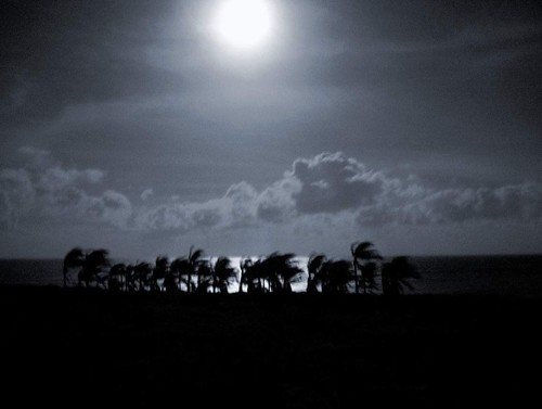
It’s Wednesday evening as I begin updating this last paragraph of today’s narrative. A light winded convective weather pattern remains in residence over the Hawaiian Islands now. Clear nights, with cooler than normal temperatures, will provide a near cloud free start to the days. As the sun gets higher in the sky, clouds will begin to form over and around the mountains later in the afternoon hours, although will be very limited in coverage. ~~~ As mentioned above, the Hawaiian Islands are enjoying a very dry period of weather, with the largest rainfall amount anywhere in the Aloha state a scant .03" during the last 24 hours…which is essentially nothing for Hawaii! The inversion layer over the islands is a very low 4,000 feet, which simply means that whatever few clouds that do form, will be very thin and not likely to drop any rain. ~~~ The next chance for an increase in showers will arrive later this weekend, as we finally see a cold front push down through the state of Hawaii Sunday into Monday. We haven’t had such a weather feature in a long time, not since well back in January. This will be a brief affair however, with cool north winds following closely in its wake…bringing more dry weather our way. ~~~ Wednesday evening at 5:31 HST will find the February full moon. For you astrology fans, it will be in the sign of Virgo. The late afternoon clouds will evaporate quickly this evening, clearing the way for great full moon viewing opportunities tonight! ~~~ Wednesday was almost an exact duplicate of Tuesday’s weather conditions. The few clouds that formed where few and far between, and remained benign in terms of precipitation. I anticipate that Thursday will be very similar to the last two days, with little change moving into Friday as well. As I’m fond of saying lately, this weather pattern is providing some of the best weather of winter 2008! I’ll be back very early Thursday morning, after a bright night of reflected sunlight off the full moon! I hope you have a great Wednesday night wherever you happen to be. Aloha for now…Glenn.
Interesting: Northern China is likely to be hit with more frequent and more severe sandstorms this year, Xinhua news agency reported on Wednesday, posing a challenge to Olympics organizers hoping for blue skies over Beijing. Sandstorms were forecast to increase this spring in the
Interesting2: Not a square kilometer of the world’s oceans has been left untouched by human activities, a new study shows. Ocean ecosystems face a wide range of threats from human sources, including overfishing, pollution, and rising ocean temperatures and ocean acidification caused by global warming. An international team of scientists gathered global data for 17 different types of these human impacts and fed them into a model that produced a map of the world’s oceans with each square kilometer assigned a value of the level of impact at that particular spot. Their results are detailed in the Feb. 15 issue of the journal Science, and were presented today at the annual meeting of the American Association for the Advancement of Science in Boston. The map showed that human activities have to some degree affected all parts of the oceans, with 41 percent being strongly impacted by several human-caused drivers. "What is new today is that… we know how much of the oceans are in trouble and this figure is frighteningly high," said co-author Fiorenza Micheli, a Stanford University marine ecologist, at a news conference in Boston.
Glenn’s TV Weather show is back online now. One day’s show will replaced with the next new days show at around 9am HST (11am PST – 2pm EST)…Monday through Friday. Thanks to the folks at the Maui Media Lab in Paia for making this happen! I was just informed that about 100 people a day are taking the time to watch the show, thanks for your viewership!