


Hawaiian Islands weather details & Aloha paragraphs
Posted by GlennFebruary 25-26 2008
Air Temperatures – The following maximum temperatures were recorded across the state of Hawaii Monday:
Lihue, Kauai – 79
Honolulu, Oahu – 83
Kaneohe, Oahu – 77
Kahului, Maui – 76
Hilo, Hawaii – 82
Kailua-Kona, Hawaii – 80
Temperatures ranged between these warmest and coolest spots near sea level at 4 a.m. Monday morning:
Honolulu, Oahu – 71F
Lihue, Kauai – 64
Precipitation Totals – The following numbers represent the largest precipitation totals (inches) during the last 24 hours on each of the major islands, as of Monday afternoon:
0.30 PORT ALLEN, KAUAI
0.93 LUALUALEI, OAHU
0.35 MOLOKAI
0.49 LANAI
0.32 KAHOOLAWE
1.62 OHEO GULCH, MAUI
0.25 HONOKAA, BIG ISLAND
Weather Chart – Here’s the latest (automatically updated) weather map. A new high pressure system will set up shop just to the north of Hawaii through Wednesday. This will cause light and variable winds across the islands.
Satellite and Radar Images: To view the cloud conditions we have here in Hawaii, please use the following satellite links, starting off with the Infrared Satellite Image of the islands to see all the clouds around the state during the day and night. This next image is one that gives close images of the islands only during the daytime hours, and is referred to as a Close-up visible image. This next image shows a larger view of the Pacific…giving perspective to the wider ranging cloud patterns in the Pacific Ocean…out from the islands. To help you keep track of where any showers may be around the islands, here’s the latest animated radar image.
Hawaii’s Mountains – Here’s a link to the live webcam on the summit of near 14,000 foot Mauna Kea on the Big Island of Hawaii. The tallest peak on the island of Maui is the Haleakala Crater, which is near 10,000 feet in elevation. These two webcams are available during the daylight hours here in the islands…and when there’s a big moon rising just after sunset for an hour or two! Plus, during the nights and early mornings you will be able to see stars, and the sunrise too…depending upon cloud conditions.
A brief period of cool north to northeast breezes have filled in behind a dissipating cold front Monday evening…gradually becoming light and variable Tuesday. The Hawaiian Islands will find light and variable breezes blowing Tuesday and Wednesday. There may be a slight drift of air coming up from the southeast direction, which could bring volcanic haze to some parts of the islands again for a couple of days. The trade winds will return briefly Thursday into Friday…although the latest model runs now show the winds going light again from the southeast and south, ahead of another cold front approaching the Aloha state late next weekend.
A weakening cold front continues to move southeast across the southern islands, with partly cloudy skies…and a few showers. The front will continue its passage down over the Big Island Monday evening into the night. Clearing will occurred over Kauai and Oahu during the day…although stable clouds are riding in on the north breezes. Looking ahead , there will be afternoon convective clouds over and around the mountains, not many showers though. Trade wind showers will take over the windward sides Thursday into Friday with a few windward showers. We should see a fairly dry weekend coming up, as a cold front passes by to the north of the islands.
It’s Monday evening as I begin updating this last paragraph of today’s narrative. The dissipating front has passed by Maui County Monday, and as this satellite image shows, some leftover clouds are hung up over the Big Island. There are a few clouds extending back over the windward side of Maui as well. Tuesday and Wednesday will find mostly clear to partly cloudy mornings, giving way to afternoon cloudy periods, with a few showers falling over the upcountry areas. The atmosphere will remain dry and stable however, so that not many showers will fall from whatever clouds that around then. As we move into later Thursday and Friday, the trade winds will return briefly, with the bias for showers shifting back over to the windward sides. ~~~ I’ll be back very early Tuesday morning with your next new weather narrative. I hope you have a great Monday night until then! Aloha for now…Glenn.
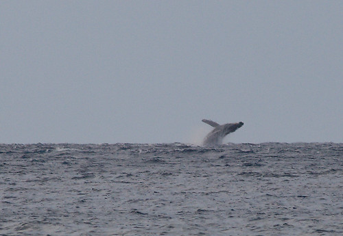
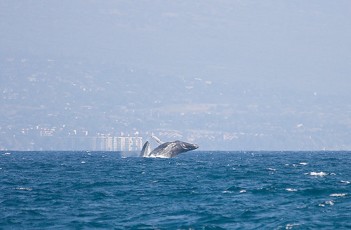
Interesting: Whale watchers counted a record number of humpback whales off Maui this weekend. Volunteers at the annual count organized by the Pacific Whale Foundation tally whale sightings and record whale behaviors from 12 shoreline observation stations. Saturday’s count of 1,726 humpback whale sightings broke the 2006 record of 1,265.
The National Oceanic and Atmospheric Administration organizes counts on other islands. More than 700 volunteers from around the state took part at 57 sites. Flat seas, a mild breeze and clear skies helped whale watchers do their job on Kauai. Crater Hill had the most sightings of any of the 15 Kauai observation stations. A dozen whales were spotted there during a 15-minute reporting period between 8 a.m. and noon.
Interesting2: The West has become 500 percent dustier in the past two centuries due to westward U.S. expansion and accompanying human activity beginning in the 1800s, according to a new study led by the University of Colorado at Boulder. Sediment records from dust blown into alpine lakes in southwest
"From about 1860 to 1900, the dust deposition rates shot up so high that we initially thought there was a mistake in our data," said Neff. "But the evidence clearly shows the western
Interesting3: A new coating for solar panels could lead to more efficient solar collection. The energy from sunlight falling on only 9 percent of
A paper about the work, which focuses on “engineering” organic material-electrode interfaces in bulk-heterojunction organic solar cells, is published online this week in the Proceedings of the National Academy of Sciences (PNAS). This breakthrough in solar energy conversion promises to bring researchers and developers worldwide closer to the goal of producing cheaper, more manufacturable and more easily implemented solar cells. Such technology would greatly reduce our dependence on burning fossil fuels for electricity production as well as reduce the combustion product: carbon dioxide, a global warming greenhouse gas.