


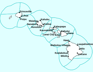
Air Temperatures – The following high temperatures (F) were recorded across the state of Hawaii Tuesday…along with the low temperatures Wednesday:
86 – 79 Lihue, Kauai
92 – 79 Honolulu, Oahu
90 – 76 Molokai AP
94 – 77 Kahului AP, Maui
88 – 82 Kona AP, Hawaii
87 – 71 Hilo, Hawaii
Here are the latest 24-hour precipitation totals (inches) for each of the islands Wednesday afternoon:
2.50 Mount Waialeale, Kauai
0.55 Manoa Lyon Arboretum, Oahu
0.22 Molokai
0.02 Lanai
0.00 Kahoolawe
1.07 Puu Kukui, Maui
1.41 Saddle Quarry, Big Island
The following numbers represent the strongest wind gusts (mph) Wednesday afternoon:
31 Port Allen, Kauai
35 Palehua, Oahu
35 Molokai
31 Lanai
42 Kahoolawe
35 Kahului AP, Maui
33 Waikoloa, Big Island
Hawaii’s Mountains – Here’s a link to the live webcam on the summit of our tallest mountain Mauna Kea (13,803 feet high) on the Big Island of Hawaii. Here’s the webcam for the 10,000+ feet high Haleakala Crater on Maui. These webcams are available during the daylight hours here in the islands, and at night whenever there’s a big moon shining down. Also, at night you will be able to see the stars, and the sunrise and sunset too…depending upon weather conditions.

There are no tropical cyclones expected in the central Pacific
(click on the images to enlarge or animate them)

Active thunderstorms offshore in several directions

Variable clouds…most of the clouds will arrive along the windward sides

Showers locally – Looping image
Small Craft Advisory…pink color below
~~~ Hawaii Weather Narrative ~~~
Broad Brush Overview: The current spell of trade wind weather conditions will continue through the remainder of the week into early next week…thanks to high pressure remaining anchored far north of the state. Clouds and passing showers will favor windward and mountain areas as usual, with the trade winds prevailing. The leeward sections of the Big Island will see clouds and showers, with those showers falling during the afternoon and evening hours for the most part.
Details: The upper level trough in the will move northwest, with the overlying atmosphere becoming more stable. Meanwhile, the high will persist far north through the rest of the week, and strengthen slightly through Thursday. The airmass may still be unstable enough for a slight chance of an upslope thunderstorm over the Big Island. The models suggest an increase in moisture for the islands Thursday…which may lead to a slight increase of passing clouds and showers then.
Looking Further Ahead: The high to our north is expected to slowly weaken by the weekend into early next week. This points to a slight downward trend in trade wind speeds then. An upper level trough may drop back southward, closer to the state. This may lead to a slight increase in shower activity, mainly for windward and mountain areas. Daytime heating will continue to allow for clouds and showers to form over the leeward Big Island slopes each afternoon and evening.
Here’s a near real-time Wind Profile of the Pacific Ocean – along with a Closer View of the islands / Here’s the latest Weather Map
Marine Environmental Conditions: High pressure north of the state will keep moderate to strong trades in place through Friday. The trades are expected to decrease slightly over the weekend, as high pressure to the north weakens. A Small Craft Advisory (SCA) remains in effect for most waters between Oahu and the Big Island. Moderate trades are expected for the remaining waters not in the SCA.
The current south swell will continue to slowly lower, with only small south and southwest swells expected Thursday through the weekend. An increase in south shore surf is possible early next week, as a pair of overlapping southwest swells arrive. Locally strong trade winds will produce choppy waves along east facing shores into the weekend. East shore surf will rise Thursday and Friday, as the upstream fetch of trade winds increases. Surf is expected to remain below advisory levels along east facing shores Thursday and Friday…and slowly lower over the weekend as trades ease.

World-wide Tropical Cyclone Activity
>>> Here’s Wednesday’s Pacific Disaster Center (PDC) Weather Wall Presentation covering the eastern, central, and western Pacific Ocean, the Indian Ocean, and the Arabian Sea…including Tropical Storm 06W (Danas), and two tropical disturbances being referred to as Invest 91W and Invest 99W
>>> Here’s Wednesday’s Pacific Disaster Center (PDC) Weather Wall Presentation covering the Atlantic Ocean, the Caribbean Sea, and the Gulf of Mexico, including Post–Tropical Cyclone 02L (Barry) which has moved well inland from the Gulf of Mexico.
>>> Atlantic Ocean: There are no active tropical cyclones
Latest satellite image of the Atlantic
>>> Caribbean Sea: There are no active tropical cyclones
Tropical cyclone formation is not expected during the next 5 days
Here’s a satellite image of the Caribbean Sea…and the Gulf of Mexico
>>> Gulf of Mexico:
Post-Tropical Cyclone 02L (Barry) – Last Advisory
NHC textual forecast Advisory
NHC graphical track map
What the computer models are showing
According to the NHC advisory #29…The post-tropical cyclone is moving toward the east near 23 mph and this motion is expected to continue today.
The low pressure center and circulation with Barry is expected to become less distinct later today or tonight.
Maximum sustained winds are near 15 mph with higher gusts. Little change in strength is forecast during the next 48 hours.
Latest satellite image of the Gulf of Mexico
>>> Eastern Pacific: There are no active tropical cyclones
1.) A tropical wave located a few hundred miles southwest of the Gulf of Tehuantepec is producing a few disorganized showers and thunderstorms. Environmental conditions are forecast to become a little more conducive for gradual development late this week, and a tropical depression could form over the weekend or early next week. This disturbance is forecast to move westward to west-northwestward at 10 to 15 mph, well south of the coast of Mexico.
* Formation chance through 48 hours…low…near 0 percent
* Formation chance through 5 days…medium…40 percent
2.) A large but disorganized area of showers and thunderstorms centered a little more than 1000 miles southwest of the southern tip of the Baja California peninsula is associated with a tropical wave. Upper-level winds appear to be somewhat conducive for some slow development during the next few days while the disturbance moves west-northwestward at 10 to 15 mph.
* Formation chance through 48 hours…low…20 percent
* Formation chance through 5 days…low…30 percent
Here’s the link to the National Hurricane Center (NHC)
>>> Central Pacific: There are no active tropical cyclones
No tropical cyclones are expected during the next 5 days.
Here’s the link to the Central Pacific Hurricane Center (CPHC)
>>> Northwest Pacific Ocean:
Tropical Cyclone 06W (Danas)
JTWC textual advisory
JTWC graphical track map
>>> South Pacific Ocean: There are no active tropical cyclones
>>>North and South Indian Oceans / Arabian Sea: There are no active tropical cyclones
Interesting: The Marshall Islands Are 10 Times More ‘Radioactive’ Than Chernobyl — Some of the Marshall Islands in the Pacific Ocean — such as the Bikini and Enewetak atolls — are still more radioactive than Chernobyl and Fukushima, even though more than 60 years have passed since the United States tested radioactive weapons there, a new study finds.
When testing the soil for plutonium-239+240, the researchers found that some of the islands had levels that were between 10 and 1,000 times higher than those on Fukushima (where an earthquake and tsunami led to the meltdown of nuclear reactors) and about 10 times higher than levels in the Chernobyl exclusion zone.
The researchers took only a limited number of soil samples, meaning a more comprehensive survey is needed, they said. Regardless, they were surprised that neither national governments nor international organizations had “any further guidance on permissible plutonium levels in the soil,” even though levels in the Marshall Islands were high, the researchers wrote in the study.
Testing bombs
After dropping atomic bombs on the Japanese cities of Hiroshima and Nagasaki in 1945, effectively ending World War II, the United States decided to test more radioactive weapons. Some of these tests happened in the Marshall Islands, a chain of islands between Hawaii and the Philippines that was then a district of the Trust Territory of the Pacific Islands — run by the U.S. on behalf of the United Nations. The first two bombs — called Able and Baker — were tested on Bikini Atoll in 1946 and kicked off a 12-year period of nuclear testing on the Bikini and Enewetak atolls, during which the U.S. tested 67 nuclear weapons.
The first-ever hydrogen bomb test, with the code name Ivy Mike, was tested on Enewetak in 1951. The U.S. conducted its largest hydrogen bomb test on Bikini Atoll — the 1954 Castle Bravo bomb, which was more than 1,000 times more powerful than “Little Boy,” the uranium weapon that decimated Hiroshima.
In addition to contaminating the Bikini and Enewetak atolls, nuclear fallout from the tests also rained down on and sickened people living on Rongelap and Utirik atolls (also part of the Marshall Islands), the researchers said. In 2016, a team of researchers from Columbia University in New York published a study in the journal Proceedings of the National Academy of Sciences (PNAS) on the background gamma radiation in three of the northern Marshall atolls: Enewetak, Bikini and Rongelap. They found that radiation levels on Bikini were higher than previously reported, so they decided to do more in-depth studies on radioactivity in the islands. (Gamma rays are like energetic X-rays that are released from nuclear weapons.)
More fallout
Now, that same team has written three new studies, published online yesterday (July 15) in the journal PNAS, on four of the atolls in the northern Marshall islands: Bikini, Enewetak, Rongelap and Utirik.
External gamma radiation levels were significantly elevated on Bikini Atoll; on Enjebi Island in Enewetak Atoll; and on Naen Island in Rongelap Atoll, compared with an island in the southern Marshall Islands that the scientists used as a control, the researchers found.
The levels on Bikini and Naen islands were so high, they surpassed the maximum exposure limit that the United States and the Republic of the Marshall Islands agreed to, the researchers said. (On a side note, bikini swimsuits weren’t named after the island because of its tropicality, but because the French designer wanted the two-piece swimsuit to be “explosive,” just like the bomb tested there, said one of the study’s senior scientists Ivana Nikolic-Hughes, director of the K1 Project at the Center for Nuclear Studies and a senior lecturer of chemistry at Columbia University in New York City.)
The researchers also found that the islands of Runit and Enjebi in Enewetak Atoll, as well as on Bikini and Naen islands, had high concentrations of certain radioactive isotopes in the soil. (An isotope is an element with a different number of neutrons than usual in its nucleus.) These four islands had radioactive plutonium levels that were higher than Fukushima and Cherbobyl, the researchers found.
“What was surprising was just how high the external gamma radiation was for Naen, which is the outer island for Rongelap Atoll,” Nikolic-Hughes told Live Science. “It was populated during the Bravo test … [the people there] were then moved, moved back and moved again. It’s quite a dreadful history of what happened to Rongelapese people.”
In their second study, the researchers worked with professional divers, who collected 130 soil samples from the Castle Bravo crater at Bikini Atoll. The level of some of the isotopes — plutonium-239,240, americium-241 and bismuth-207 — was an order of magnitude higher than levels found on other Marshall Islands, the researchers found.
These findings are important because “measuring the radioactive contamination of the crater sediment is a first step in assessing the overall impact of nuclear weapons testing on the ocean ecosystems,” the researchers wrote in the study.
In the third study, the researchers tested more than 200 fruits — mostly coconuts and pandanus — on 11 of the islands from four different atolls in the northern Marshall Islands. Cesium-137 levels didn’t look good for a sizeable chunk of the fruits on Bikini and Rongelap atolls, which had radioactivity levels higher than those deemed safe by several countries and international organizations, the researchers found.
More work is needed to educate people living on the Marshall Islands about these dangers, including on any decisions to resettle some of these islands, the researchers said.
Tom Barca Says:
Aloha Glenn,I’ve noticed we get more and more southeast winds. Tradewinds are tradionally east northeast .So my question is are these winds considered tradewinds as the TV weathermen call them or should we call them something else?
~~~ Hi Tom, yours is a good question. You’re correct, we are seeing more frequent bouts of southeasterly winds coming into the state…which is catching my eye too. As for your question, no, southeasterly winds are not considered the trades. I think of the classic trade winds arriving from the east-northeast to easterly directions.
Southeast winds can bring warmer than normal temperatures, both at night and during the days, and often more humid air…less refreshing than the ordinary trades.
Aloha, Glenn
Steve W Says:
I’ve seen red #s for about a month for the high in Kahahlui , have we set a record for # of days with new high temperatures for this time of year ?
~~~ Hi Steve, that’s a good question. I bold and redden the high temperatures which reach 90 or above. I used to be able to use the NWS page for local records, to indicate which high temperatures tied or broke the old records for the date. However, their page showing records is no longer available on their site. I have notified the person in charge of that page, and was told that it would be fixed when they could. I’ll keep checking their page, and when it comes back…I’ll begin noting when the old records are tied or broken again.
However, with that being said…it’s been hot at the Honolulu and Kahului airports!
Aloha, Glenn
Sandra J Says:
Belated Happy Birthday Glenn! I am a big fan as well, but bow to Mama James. Hope your day was very special, and thank you for all that you do. Stay safe, and don’t eat too much birthday cake!! Another big fan!!
~~~ Hi Sandra, thanks for your BD wishes…much appreciated!
Indeed, my Mom, after reading these comments, has informed me that SHE IS my biggest fan! (Smiling again)
I appreciate your positive feedback, and I’ll limit my eating of birthday cake!
Aloha, Glenn
Nancy Lorenz Says:
I beg to differ, Bob. I am Glenn’s biggest fan!
HAPPY (belated) BIRTHDAY, Glenn!
NANCY
~~~ Hi Nancy thanks for your BD wishes.
I’m afraid that I’ll have to beg to differ here as well, as I’m sure my Mom would have to chime in here…”no I’m his biggest fan.” (I’m smiling)
At any rate, I greatly appreciate all this fanfare…thank you very much Nancy (and again Bob)!
Aloha, Glenn
Bob Says:
Hi Glenn,
These birthdays are getting old but I still wanted to wish you one, so…”Happy Birthday Glenn.” I’m still your biggest fan!
Aloha
~~~ Hi Bob, thanks so much for your BD wishes, and it’s so true…these numbers are getting old.
As for being my biggest fan, I’ll take your vote of confidence, and your fandom…and am pleased to have it!
Aloha, Glenn