


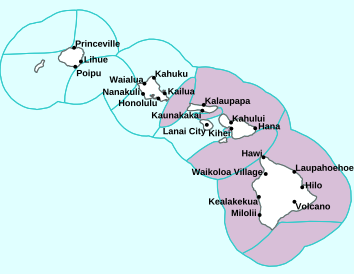
Air Temperatures – The following high temperatures (F) were recorded across the state of Hawaii Monday…along with the low temperatures Monday:
79 – 68 Lihue, Kauai
81 – 66 Honolulu, Oahu
84 – 67 Molokai AP
89 – 67 Kahului AP, Maui
83 – 70 Kona AP, Hawaii
81 – 66 Hilo, Hawaii
Here are the latest 24-hour precipitation totals (inches) for each of the islands Monday evening:
4.53 Hanalei, Kauai
3.20 Makaha Stream, Oahu
0.54 Molokai
1.89 Lanai
0.01 Kahoolawe
2.58 Kula 1, Maui
3.71 Kohala Ranch, Big Island
The following numbers represent the strongest wind gusts (mph) Monday evening:
22 Mana, Kauai
22 Kuaokala, Oahu
20 Molokai
22 Lanai
27 Kahoolawe
22 Maalaea Bay, Maui
18 PTA West, Big Island
Hawaii’s Mountains – Here’s a link to the live webcam on the summit of our tallest mountain Mauna Kea (nearly 13,800 feet high) on the Big Island of Hawaii. Here’s the webcam for the 10,000+ feet high Haleakala Crater on Maui. These webcams are available during the daylight hours here in the islands, and at night whenever there’s a big moon shining down. Also, at night you will be able to see the stars, and the sunrise and sunset too…depending upon weather conditions.

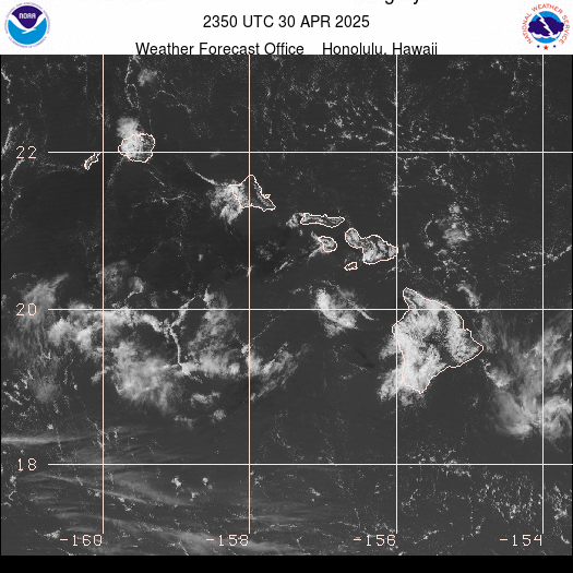
A cold front north…with a swath of high clouds moving by south of the Big Island
(click on the images to enlarge them)

Multi-layered clouds across the state

Partly to mostly cloudy
Closest View

Showers locally…some are heavy – Looping image
Small Craft Advisory…pink color below
~~~ Hawaii Weather Narrative ~~~
Broad Brush Overview: A trough of low pressure will remain nearly stationary over the state, keeping a land and sea breeze pattern in place, with the potential for locally heavy rainfall and thunderstorms. Moderate trade winds will return tonight through Thursday, with showers favoring windward areas, with a few shower reaching leeward. A cold front will approach from the northwest Friday, and move into the island chain over the weekend…bringing an unsettled and potentially wet weather pattern to the state.
Details: A land breeze and sea breeze pattern will continue, with showers favoring interior and mountain areas during the afternoon and evening, and the coastal waters and locations near the coast at night into the early morning. An upper level trough will approach from the west and move through the islands, bringing a core of cold air over the state. This cold air aloft may be enough to prompt a few strong thunderstorms, with even some gusty winds and hail possible.
A more typical trade wind pattern will return Tuesday, with moderate trades expected through Thursday. Showers will favor windward areas, with a stray shower reaching leeward areas from time to time. The trades will then falter again Thursday night and Friday, with a return to more of a convective pattern Friday afternoon into the evening. The models haven’t converged on a decision yet, so that the forecast details may change over the next few days…stay tuned.
Looking Further Ahead: The models suggest that the trough of low pressure will remain nearly stationary in the vicinity of Oahu for the time being, before dissipating tonight as high pressure builds northwest of the state. High pressure will then shift eastward well to the north of the islands through Friday. A late season cold front will then approach from the northwest Friday, and move into the islands over the weekend.
Here’s a near real-time Wind Profile of the Pacific Ocean – along with a Closer View of the islands / Here’s the latest Weather Map
Marine Environmental Conditions: A weak surface trough in the vicinity of Oahu is maintaining light and variable winds across the coastal waters. In addition, an upper-level trough moving across the area from west to east will destabilize the atmosphere. This will result in locally heavy downpours and a chance of thunderstorms.
The surface trough will eventually dissipate as a new surface high pressure system builds far northwest of the area. This will allow moderate to locally breezy trade winds to develop across the area tonight through mid-week. The latest forecast indicates winds will likely reach the Small Craft Advisory criteria over the typically windier waters adjacent to the islands of Maui County and the Big Island Tuesday through Wednesday night. The flow will begin to weaken again Thursday through Friday…as a new front approaches from the northwest.
The current moderate northwest swell is expected to peak, then gradually subside tonight through mid-week. A small reinforcing northwest swell arriving late Wednesday will persist into the weekend.
A series of small south and southwest swells will maintain small to moderate surf along south facing shores through the weekend. Surf may briefly increase along east facing shores around mid- week as the trade winds strengthen. Otherwise, expect small surf along east facing shores into early next week.

World-wide Tropical Cyclone Activity
Here’s the latest Pacific Disaster Center (PDC) Weather Wall Presentation covering the western Pacific Ocean, the Indian Ocean, and the Arabian Sea, including Tropical Cyclone 01B (Fani)
>>> Atlantic Ocean: The 2019 hurricane season begins June 1, 2019
Here’s a satellite image of the Atlantic
>>> Gulf of Mexico: The 2019 hurricane season begins June 1, 2019
>>> Caribbean Sea: The 2019 hurricane season begins June 1, 2019
Here’s a satellite image of the Caribbean Sea…and the Gulf of Mexico
>>> Eastern Pacific: The 2019 hurricane season begins May 15, 2019
Here’s the link to the National Hurricane Center (NHC)
>>> Central Pacific: The 2019 hurricane season begins June 1, 2019
Here’s the link to the Central Pacific Hurricane Center (CPHC)
>>> Northwest Pacific Ocean: There are no active tropical cyclones
>>> South Pacific Ocean: There are no active tropical cyclones
>>> North and South Indian Oceans / Arabian Sea:
Tropical Cyclone 01B (Fani)
JTWC textual advisory
JTWC graphical track map
Interesting: The Ocean’s Biggest Waves Are Getting Even Bigger – Ocean waves all over the world are growing bigger, driven by an increase in extreme winds.
That’s the upshot of a new study that used 33 years of satellite data to monitor changes in the ocean. The researchers, a pair of scientists from the University of Melbourne in Australia, have built the largest-ever database of wind and wave data, and found that both increased significantly between 1985 and 2018.
The most extreme changes involved the fastest winds and highest waves: The top 10% of winds increased in speed by 4.9 feet per second, and the top 10% of waves increased in height by a foot over the same period. That amounts to an 8% increase in the speed of extreme winds, and a 5% increase in the height of extreme waves. The findings were published Thursday (April 25) in the journal Science.
“Although increases of 5% and 8% might not seem like much, if sustained into the future such changes to our climate will have major impacts,” Ian Young, one of the study authors, said in a statement.
Most importantly, they said, more intense waves mean increased risk of flooding in coastal communities, and faster erosion of coastal lands. The changes could speed the rate at which low-lying regions end up underwater, accelerating the effects of sea level rise.
To confirm that this past data, taken from many different satellites, was correct, the researchers compared the findings to decades of data from 80 worldwide ocean buoys. They found the two datasets matched neatly.
The Southern Hemisphere feels the strongest effects of the growing waves, the researchers reported. But people in the Northern Hemisphere don’t get a reprieve.
“These changes have impacts that are felt all over the world,” Young said.
The study, part of an effort to refine global climate models, should also help researchers understand atmosphere-water interactions, which depend in part on the roughness of the waters, the authors noted.
Tyler Paikuli-Campbell Says:
Aloha Glenn,
Mahalo for your long term commitment to sharing your expertise and observations. What are your thoughts about human engineering of weather in Hawaii?
Mahalo,
Tyler
~~~ Hi Tyler, thanks for your acknowledgement! As far as my thoughts about human engineering of weather in Hawaii…I honestly don’t have any. I don’t even know what human engineering of weather is actually. I know that some people think that high flying jets are spewing out chemicals of some sort…although I’ve never bought into that personally.
Aloha, Glenn