


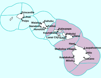
Air Temperatures – The following high temperatures (F) were recorded across the state of Hawaii Friday…along with the low temperatures Friday:
77 – 66 Lihue, Kauai
81 – 69 Honolulu, Oahu
75 – 62 Molokai AP
81 – 63 Kahului AP, Maui
81 – 68 Kona AP, Hawaii
80 – 64 Hilo, Hawaii
Here are the latest 24-hour precipitation totals (inches) for each of the islands Friday evening:
0.22 Princeville AP, Kauai
1.39 Kahuku, Oahu
0.76 Molokai
0.16 Lanai
0.01 Kahoolawe
0.95 Ulupalakua, Maui
1.32 Kawainui Stream, Big Island
The following numbers represent the strongest wind gusts (mph) Friday evening:
14 Poipu, Kauai
29 Oahu Forest NWR, Oahu
18 Molokai
24 Lanai
27 Kahoolawe
22 Maalaea Bay, Maui
22 Kohala Ranch, Big Island
Hawaii’s Mountains – Here’s a link to the live webcam on the summit of our tallest mountain Mauna Kea (nearly 13,800 feet high) on the Big Island of Hawaii. Here’s the webcam for the 10,000+ feet high Haleakala Crater on Maui. These webcams are available during the daylight hours here in the islands, and at night whenever there’s a big moon shining down. Also, at night you will be able to see the stars, and the sunrise and sunset too…depending upon weather conditions.

The cold front is stalling and dissipating
(click on the images to enlarge them)

This front brought clouds and showers

Partly to mostly cloudy…clear areas leeward

Showers locally – Looping image
Small Craft Advisory…pink color below
~~~ Hawaii Weather Narrative ~~~
Broad Brush Overview: Leftover showers associated by the dissipating cold front will fall mainly over parts of windward Maui and the Big Island. A high pressure area passing by to the north of the islands will briefly return locally gusty trades. These trades will falter Sunday as a ridge of high pressure develops over the islands. Light winds with daytime sea breezes and nighttime land breezes are then expected well into next week, as the ridge remains nearly stationary near the islands…allowing afternoon and evening clouds along with a few showers.
Details: Showery clouds along the dissipating front, is mainly evident over Maui County and parts of the Big Island. This moisture will continue to fragment and break up, leading to some enhanced trade wind showers for windward Maui county and portions of the Big Island into Saturday morning…before the winds taper off again later in the weekend. Upper level ridging and slight warming aloft should allow for a relatively dry convective pattern over the weekend, with some afternoon clouds, although with limited upcountry showers.
Looking Ahead: The convective pattern may get a little more active Monday and Tuesday, as a low pressure trough builds over the islands, and moisture increases a bit. The GFS model is suggesting moisture from the trailing end of a front may bring an increase in showers to Kauai later Monday, although the ECMWF keeps it to our northwest. Mid-level warming once again should bring us back to a drier convective pattern Wednesday into Thursday, and possibly beyond. The ECMWF shows another push of remnant moisture in our direction next Friday.
Here’s a near real-time Wind Profile of the Pacific Ocean – along with a Closer View of the islands / Here’s the latest Weather Map
Marine Environmental Conditions: A surface high northwest of the area will move southeast, with winds over the coastal waters swinging around to northeast trade winds. Over the weekend, as the high moves farther east and a new cold front approaches from the northwest, winds will veer to the east, then southeast. East to southeast winds may reach the 25 knot Small Craft Advisory threshold around the Big Island Saturday night. Winds will then weaken and shift south next week as the front gets closer.
A new northwest swell is moving into the coastal waters. Surf from his swell is expected to remain just below advisory levels. The current swell will shift to the north and fade out by Monday. Surf from a west-northwest swell expected Sunday night, will likely remain below the advisory threshold. Larger west-northwest swells peaking Wednesday and Thursday are expected to produce advisory level surf. A very large northwest swell may arrive next Thursday night.

World-wide Tropical Cyclone Activity
Here’s Friday’s Pacific Disaster Center (PDC) Weather Wall Presentation covering the western Pacific Ocean, the Indian Ocean, and the Arabian Sea, including a tropical disturbance which is being referred to as Invest 01W in the western Pacific…and Invest 92S in the Mozambique Channel
>>> Atlantic Ocean: The 2019 hurricane season begins June 1, 2019
Here’s a satellite image of the Atlantic
>>> Gulf of Mexico: The 2019 hurricane season begins June 1, 2019
>>> Caribbean Sea: The 2019 hurricane season begins June 1, 2019
Here’s a satellite image of the Caribbean Sea…and the Gulf of Mexico
>>> Eastern Pacific: The 2019 hurricane season begins May 15, 2019
Here’s the link to the National Hurricane Center (NHC)
>>> Central Pacific: The 2019 hurricane season begins June 1, 2019
Here’s the link to the Central Pacific Hurricane Center (CPHC)
>>> Northwest Pacific Ocean: No active tropical cyclones
>>> South Pacific Ocean: No active tropical cyclones
>>> North and South Indian Oceans / Arabian Sea: No active tropical cyclones
Here’s a link to the Joint Typhoon Warning Center (JTWC)
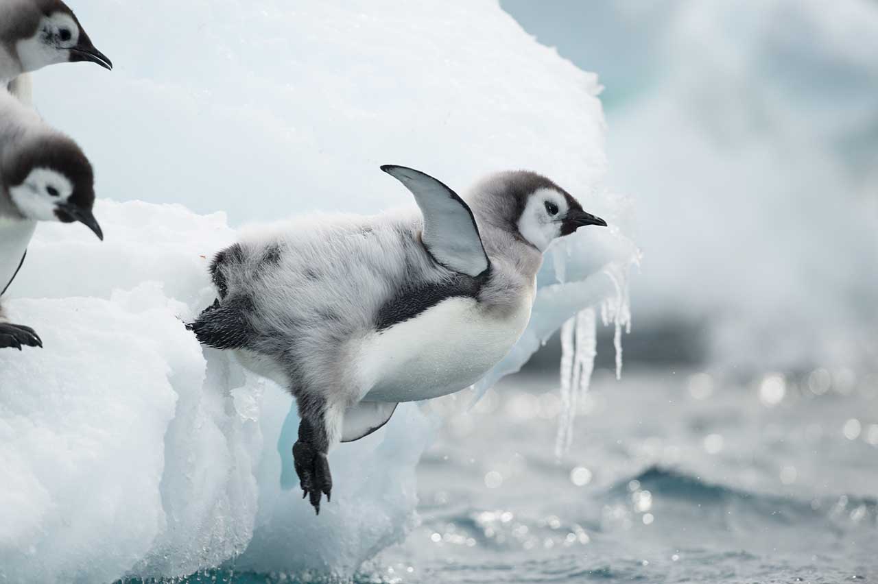
Interesting: Emperor Penguins’ First Journey to Sea – Emperor penguin chicks hatch into one of Earth’s most inhospitable places—the frozen world of Antarctica. Childhood in this environment is harsh and lasts only about five months, when their formerly doting parents leave the fledglings to fend for themselves.
New research by the Woods Hole Oceanographic Institution (WHOI) and colleagues reveals the previously unknown behaviors of juvenile Emperor penguins in their critical early months when they leave their birth colony and first learn how to swim, dive, and find food. The paper, published January 17, 2019, in the journal Marine Ecology Progress Series, also highlights the unique connection between juvenile diving behaviors and a layer of the ocean, known as the thermocline, where warmer surface waters meet cooler deep waters below and where their prey likely gather in groups.
“This study provides insights into an important, but poorly understood, part of their life cycle, which is essential to being able to better predict the species’ response to future climate change,” says Sara Labrousse, a postdoctoral investigator at WHOI and lead author of the paper.
Researchers from Centre d’Etudes Biologiques de Chize in France tagged 15 juvenile penguins before the animals left their colony in Terre Adélie during 2013 and 2014 fieldwork in December, when the weather usually starts to warm and the ice begins to break up, creating open waters near the nesting site.
The researchers attached tags to the lower backs of healthy chicks that had the best chances of survival. The tags recorded the penguins’ movements and transmitted diving and location data via satellite. More than 62,000 dives were recorded.
The tags revealed that the juvenile penguins initially moved far north to reach open water areas and warmer waters.
“This is when they are essentially learning how to swim,” says Labrousse. “That’s not something that their parents teach them. When they first go in the water, they are very awkward and unsure of themselves. They are not the fast and graceful swimmers their parents are.”
The tags showed that once the juvenile Emperor penguins became more experienced at diving, they headed south, entered the sea ice zone where they spent the winter months making deeper dives within sea ice.
“That was something that surprised us because we didn’t previously know how long they were staying within the sea ice,” Labrousse says. “It turns out that they spend most of the winter diving beneath the sea ice.”
The thermocline starts to deepen in autumn. The animals’ deeper dives likely were related to the depth of the thermocline and the seasonal change in the distribution of their prey, krill and other fish from the surface to the depths, Labrousse says. The deepest dive recorded by the tags was to 264 meters.
“The next step in this research would be to utilize tags that could record death at-sea,” says Labrousse. “That would give us data on their survival rates, which we don’t have for this study.”
Tags stopped recording dives after less than one day on two individuals, while one individual’s tag stopped after 31 days. The tags on the remaining 12 penguins, recorded trips lasting from 86 to 344 days.
“In those cases when the tags stop transmitting, we don’t know whether something happened to the animal or if it was due to a battery or other technical problem with the tag,” Labrousse adds.
Emperor penguins are the largest species of penguins. They are particularly vulnerable to climate change because their life cycles are so dependent on sea ice. Their breeding cycle begins in March (autumn in Antarctica) when the sea ice is thick enough to support their colony.
After laying a single egg each, the females leave the colony to catching fish and fatten up so they can feed their chicks. The males stay behind and cradle the egg on the tops of their feet, tucked under their brooding pouch for warmth and protection. Too little sea ice during this time can reduce the availability of breeding sites and prey; too much sea ice means longer hunting trips for adults, which in turn means lower feeding rates for chicks.
“Juveniles stay at sea for five or six years before they return to the colony to mate,” says Stephanie Jenouvrier, biologist at WHOI and coauthor of the study. “We need to better understand the dynamics of what happens during the time the juveniles are away from the colony. Understanding how they will respond to the changing landscape in terms of breeding and other life history stages is key to predict population responses and species persistence to future climate change.”
Nancy Lorenz Says:
Aloha e Glenn,
We are enjoying a good soaking up here, as I’m sure you know. I never tire of the rain because I know it is not long-lived. We are lucky to be warm and safe while our thirsty earth soaks it up.
I appreciate that your priorities are in the right place. You have always been a very engaging writer, attracting many to tune in to your every word. For now, we are lucky you take the time to keep up this precious weather narrative for all of us to enjoy. I think of you as one of the pioneer bloggers. Many thanks for your dedication all these years.
Enjoy the time you have with your mom.
With gratitude,
Nancy
~~~ Hi Nancy, thank you for understanding, I greatly appreciate that…and the kind words you have shared.
You are one of the long term readers/visitors of my website, after all these many years.
I feel the same as you, I greatly enjoy the winter storms, as they bring our thirsty earth and its inhabitants…good water for the living.
I am enjoying my Mom’s company, she’s so sharp, despite her advanced age…I feel fortunate to be able to spend this precious time with her.
I wish you and your family well, up there in wonderful Sonoma County…one of my favorite places to be!
Aloha, Glenn
Manish Says:
Hi Glenn,
Thank you so much for keeping up the site and the commentary, very appreciated and precious. Best wishes to you and mamma 🙏🙏
~~~ Hi Manish, thanks for your positive feedback, my Mom and I both appreciate your kind words of encouragement!
Aloha, Glenn
Steven Says:
Glenn:
I miss your personal comments. Used to look forward to them, like a postcard from a familiar friend. Bring them back, that was fun keeping up with The Glenn!
Steve and Diane
~~~ Hi Steve and Diane, good to hear from you. I’m sorry that I’m not able to provide those personal comments anymore, at least for the time being. The reason is that I’m now headquartered at my Mom’s house in Long Beach, California, and have been for the most part…over the past couple of years. My Mom is 96+, and she needs my care, so I’m here until her health improves.
I’m certainly willing to continue this website, although without the personal touches…which I’ve been doing steadily since 1996. I trust you and all the rest of my long time readers will understand.
Aloha, Glenn