


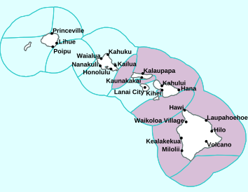
Air Temperatures – The following high temperatures (F) were recorded across the state of Hawaii Tuesday…along with the low temperatures Tuesday:
78 – 72 Lihue, Kauai
84 – 73 Honolulu, Oahu
86 – 65 Molokai AP
88 – 62 Kahului AP, Maui
85 – 70 Kailua Kona, Hawaii
83 – 67 Hilo, Hawaii
Here are the latest 24-hour precipitation totals (inches) for each of the islands Tuesday evening:
2.29 Mount Waialeale, Kauai
0.31 Maunawili, Oahu
0.01 Molokai
0.00 Lanai
0.00 Kahoolawe
0.02 West Wailuaiki, Maui
0.03 Pahoa, Big Island
The following numbers represent the strongest wind gusts (mph) Tuesday evening:
18 Port Allen, Kauai
29 Oahu Forest NWR, Oahu
20 Molokai
23 Lanai
27 Kahoolawe
25 Maalaea Bay, Maui
21 Kealakomo, Big Island
Hawaii’s Mountains – Here’s a link to the live webcam on the summit of our tallest mountain Mauna Kea (nearly 13,800 feet high) on the Big Island of Hawaii. Here’s the webcam for the 10,000+ feet high Haleakala Crater on Maui. These webcams are available during the daylight hours here in the islands, and at night whenever there’s a big moon shining down. Also, at night you will be able to see the stars, and the sunrise and sunset too…depending upon weather conditions.
Aloha Paragraphs

More high clouds approaching the state from the northwest
(click on the images to enlarge them)

Increasing clouds on the horizon

Partly cloudy skies…many clear areas

Just a few showers locally – Looping image
High Surf Advisory…purple color below
~~~ Hawaii Weather Narrative ~~~
Broad Brush Overview: Gusty trades will carry passing low clouds and a few brief windward showers our way. Winds will weaken tonight and Wednesday, with mostly dry conditions prevailing. Trade winds will strengthen again Thursday and Friday, and remain breezy into the weekend…likely bringing increased windward showers. Rainfall may become more widespread, as an upper-level low develops near the islands. Look for periods of high clouds, becoming quite thick at times.
Details: As the trade wind supporting high pressure ridge to the north weakens, the trades will gradually diminish. A low and cold front well northwest, will pass by north of the islands late tonight through Wednesday night, with the winds becoming light and variable Wednesday. Mostly dry conditions are expected to persist as a land and sea breeze pattern develops, with the best chance for showers over island interiors Wednesday afternoon.
A new high pressure system building to the northwest will bring gradually strengthening trades Thursday and Friday. As moisture associated with the cold front enters the upstream trade flow…windward showers should increase. Toward the end of the week, the high will support breezy trade winds as it moves to a position north of the islands…while a low pressure system aloft develops.
Models show the low will be located southwest of the islands by the weekend, making the trade wind flow quite showery. The associated cold air aloft over the islands, may bring deep convection leading to heavy rainfall. While confidence is low as to the details regarding the timing and potential for heavy rainfall, the persistent trade wind flow will keep the highest rain chances over the windward areas.
Periods of high cirrus clouds are expected through the weekend, as the subtropical jet stream moves over the area, with some cirrus already moving across the islands. After a possible brief break tonight, forecast guidance indicates that high clouds will become quite thick statewide Wednesday into Thursday. Depending on the evolution and track of the low…areas of high clouds may linger over portions of the state through the weekend.
Looking Ahead: A trend to a more typical trade wind weather pattern is forecast for the beginning of next week as the low weakens.
Here’s a near real-time Wind Profile of the Pacific Ocean – along with a Closer View of the islands / Here’s the latest Weather Map / Here’s the latest Vog Forecast Animation / Here’s the Vog Information website
Marine Environmental Conditions: The surf will increase across most of the islands exposed north and west facing shores, peaking tonight and Wednesday, before lowering Thursday. A reinforcing northwest swell will arrive Thursday night into Friday. This means potential high surf for the north and west facing shores once more. A smaller north swell will help reinforce this dissipating swell over the weekend.
Surf along east facing shores will be on the rise as well over the weekend, due to the stronger trades…although will stay below advisory levels. The south facing shores will continue to have a small southerly swell.

Waimanalo Beach…Oahu
World-wide Tropical Cyclone Activity
Here’s the latest Pacific Disaster Center (PDC) Weather Wall Presentation covering a tropical disturbance, being referred to as Invest 96L…in the Atlantic Ocean
Here’s the latest Pacific Disaster Center (PDC) Weather Wall Presentation covering the Pacific and Indian Oceans, including a tropical disturbance in the western Pacific, retiring Tropical Cyclone 04S (Bouchra)…and Tropical Cyclone 07B (Gaja) in the South Indian Ocean
>>> Atlantic Ocean: No active tropical cyclones
Disorganized showers and thunderstorms over portions of the Leeward Islands, the Virgin Islands, Puerto Rico, and the adjacent waters are associated with a tropical wave interacting with an upper-level low. Significant development of this system is not expected due to unfavorable upper-level winds and interaction with the islands of the Greater Antilles. Even though development is unlikely, locally heavy rainfall is expected to continue over portions of the Leeward Islands, the Virgin Islands, and Puerto Rico over the next day or so as the system moves generally west-northwestward. This activity will then spread over the Turks and Caicos Islands and the southeastern Bahamas Wednesday night and Thursday as the system turns northwestward.
* Formation chance through 48 hours…low…10 percent
* Formation chance through 5 days…low…10 percent
Here’s a satellite image of the Atlantic
>>> Gulf of Mexico: No active tropical cyclones
>>> Caribbean Sea: No active tropical cyclones
Here’s a satellite image of the Caribbean Sea…and the Gulf of Mexico
>>> Eastern Pacific: No active tropical cyclones
Here’s the link to the National Hurricane Center (NHC)
>>> Central Pacific: No active tropical cyclones
Here’s the link to the Central Pacific Hurricane Center (CPHC)
>>> Northwest Pacific Ocean: No active tropical cyclones
Here’s what the computer models show
>>> South Pacific Ocean:
Tropical Cyclone 07B (Gaja)
JTWC textual advisory
JTWC graphical track map
>>> North and South Indian Oceans / Arabian Sea:
Tropical Cyclone 04S (Bouchra) – Final Warning
JTWC textual advisory
JTWC graphical track map
Here’s a link to the Joint Typhoon Warning Center (JTWC)
Interesting: ‘Move More and Sit Less’: These Are the New Physical Activity Guidelines for Americans – After a decade, Americans have new physical activity guidelines to aim for — and officials hope the changes will get more people encouraged to get moving.
That’s because the new guidelines, released November 12th by the U.S. Department of Health and Human Services (HHS), say that any exercise is better than none. In other words, even as little as a few minutes of exercise will count towards your daily exercise goal.
That’s a change from the older guidelines, which said that in order to get the full health benefits of exercise, you needed to perform an activity for at least 10 minutes at a time. But “we now know that any amount of physical activity has some health benefits,” Dr. Brett Giroir, the Assistant Secretary for Health at HHS, said here today at a talk on the new guidelines at the American Heart Association’s Scientific Sessions annual meeting.
Otherwise, the basic guidelines stayed largely the same: Adults need 150 to 300 minutes of moderate to vigorous aerobic activity each week — which translates to around 7,000 to 9,000 steps each day. Muscle-strengthening activities, such as pushups, sit-ups or weight lifting, are recommended at least twice a week.
For children and adolescents ages of 6 to 17, the guidelines also stayed the same. They recommend at least an hour of moderate to vigorous activity each day.
Another change is that the new guidelines now include a new group: young children. Kids ages 3 to 5 should be getting at least 3 hours of activity a day, in order to promote growth and development, especially for their bones, Giroir said.
But currently, only about 26 percent of men, 19 percent of women and 20 percent of adolescents in the U.S. meet the physical activity guidelines, Giroir said. And though trends and studies show that adults are becoming more active, activity rates among adolescents are declining.
Physical activity as a ‘wonder drug’
Inactivity contributes to 10 percent of all early deaths in the U.S., Giroir said. So “if we can get just 25 percent of inactive people to be active and meet the recommendations, almost 75,000 deaths would be prevented in the United States,” Giroir said.
Physical activity is sometimes called “the wonder drug,” Janet Fulton, chief of the Physical Activity and Health Branch at the Centers for Disease Control and Prevention (CDC), said at today’s presentation. In fact, some doctors are now using prescription pads to prescribe physical activity to patients, she said.
Physical activity not only decreases the risk of early death, but also has many short-term and long-term benefits, according to the new guidelines. Some of the benefits of exercise are immediate — it reduces anxiety and blood pressure, improves sleep and improves insulin sensitivity (which can reduce the risk of type 2 diabetes).
In the long-term, physical activity has been shown to improve brain health and cognition, reduce the risk of falls for older adults (by strengthening bones or improving balance), slow the progression of hypertension and type 2 diabetes, decrease pain for those with osteoarthritis, reduces the risk of postpartum depression, and some research has shown that it may reduce the risk of developing dementia.
Physical activity has also been shown to help reduce the risk of certain cancers. In the first edition of the guidelines, only two cancers were listed: breast and colon cancer. The updated edition adds that physical activity could also reduce the risk of bladder, endometrium, esophagus, kidney, stomach and lung cancer.
Girior summed up the recommendations in a few words: “Move more and sit less.”
Jessie Says:
Glenn, I just want to say thank you for this wonderful website. My husband and I just returned from a special 20th anniversary trip to Kauai. I religiously read this site before and during our week and a half there. It was so interesting to read about island weather—and I also learned the phrase “liquid sunshine” on the local news 🙂 I will miss coming to your site each day with my morning coffee!
Aloha from the beautiful Shenandoah Valley in Virginia,
Jessie
~~~ Hi Jessie, great to hear of your 20th Anniversary vacation to Kauai!
I’m very happy to hear that you were able to use my website prior to arriving, and while you were there. Sometimes folks check back occasionally…to rekindle the afterglow of their trips.
Wow, the Shenandoah Valley, I’ve never been there, although have heard wonderful things about that part of the world.
Be well, and enjoy heading into the holiday period of the year.
Aloha, Glenn