


Air Temperatures – The following high temperatures (F) were recorded across the state of Hawaii Thursday…along with the low temperatures Thursday:
86 – 76 Lihue, Kauai
92 – 76 Honolulu, Oahu
88 – 77 Molokai AP
89 – 77 Kahului AP, Maui
88 – 73 Kailua Kona
86 – 73 Hilo AP, Hawaii
Here are the latest 24-hour precipitation totals (inches) for each of the islands Thursday evening:
0.32 Wainiha, Kauai
0.39 Poamoho RG 1, Oahu
0.90 Molokai
0.00 Lanai
0.00 Kahoolawe
1.44 West Wailuaiki, Maui
2.29 Wiakea Experiment Stn, Big Island
The following numbers represent the strongest wind gusts (mph) Thursday evening:
16 Poipu, Kauai
27 Oahu Forest NWR, Oahu
23 Molokai
27 Lanai
24 Kahoolawe
29 Maalaea Bay, Maui
27 Kealakomo, Big Island
Hawaii’s Mountains – Here’s a link to the live webcam on the summit of our tallest mountain Mauna Kea (nearly 13,800 feet high) on the Big Island of Hawaii. Here’s the webcam for the 10,000+ feet high Haleakala Crater on Maui. These webcams are available during the daylight hours here in the islands, and at night whenever there’s a big moon shining down. Also, at night you will be able to see the stars, and the sunrise and sunset too…depending upon weather conditions.
Aloha Paragraphs

Hurricane 14E (Lane) remains active in the eastern Pacific (click images to enlarge)

We’ll need to keep a close eye on what hurricane Lane is doing…as it likely passes by south of Hawaii next week

The remnant moisture from Former tropical cyclone Kristy…is approaching from the east

Clear to partly cloudy…some cloudy areas

Lower clouds arriving on the trades from the east

Showers locally and offshore
Looping image
~~~ Hawaii Weather Narrative ~~~
Broad Brush Overview: A high pressure system far northeast of the islands will remain in place through early next week. Tropical moisture will move from east to west across the state through the weekend. Drier air will move over the islands Monday in its wake. Meanwhile. tropical Storm Lane will strengthen to a hurricane and move into the central Pacific Saturday…although it’s too soon to know if Lane will directly affect the Hawaiian Islands.
Details: The high to our northeast will move northeast slowly through early next week. This distant high will maintain light to moderate trade winds over the islands. An area of moist air associated with a trough in the lower atmosphere has been moving west across the islands. A trough higher in the atmosphere northwest of the islands is making the atmosphere somewhat unstable. The combination of moisture and instability will keep showers active for the next few days.
Since trade winds will continue, showers will be focused over windward areas, although clouds will build enough to spill over to some leeward areas. Thunderstorms will be possible over the Big Island during the afternoons and evenings. A new area of tropical moisture will spread over the islands during the weekend and enhance showers even more.
Looking Ahead: Tropical Storm Lane, now far east-southeast of the islands, is forecast to strengthen to a major hurricane and move into the central Pacific over the weekend. An indirect impact from Lane is possible early next week, as drier air from subsidence ahead of the hurricane spreads over the islands Monday. Precipitation is still highly uncertain next week…as it depends on how close the system gets to the state.
Here’s a near real-time Wind Profile of the Pacific Ocean – along with a Closer View of the islands / Here’s the latest Weather Map / Here’s the latest Vog Forecast Animation / Here’s the Vog Information website
Marine Environmental Conditions: Light to moderate trade winds are expected to continue through the weekend. Winds are expected to remain below Small Craft Advisory levels, with an increase in winds possible early next week. Shower activity is expected to increase this weekend, particularly over the windward waters as tropical moisture moves in from the east.
No significant swells are expected over the next several days, so expect surf to remain small on all shores. A small south swell is expected to arrive, peak Friday and hold through Saturday…at heights below the summer average. Tropical Cyclone Lane may bring an easterly swell to the coastal waters as early as Monday of next week.

Credit…Anthi Skarmouthsou
World-wide Tropical Cyclone Activity
Here’s the Friday Pacific Disaster Center (PDC) Weather Wall Presentation covering Tropical Cyclone 05L (Ernesto) in the Atlantic Ocean
Here’s the Thursday Pacific Disaster Center (PDC) Weather Wall Presentation covering the Pacific and Indian Oceans, including Tropical Cyclone 20W (Bebinca), Tropical Cyclone 21W (Rumbia), Tropical Cyclone 22W (Soulik) and Tropical Cyclone 14E (Lane)
>>> Atlantic Ocean:
Tropical Storm 05L (Ernesto)
Here’s what the computer models are showing
According to the NHC…Ernesto is moving quickly toward the northeast near 25 mph, and an even faster motion toward the northeast or east-northeast is expected during the next day or two. On the forecast track, Ernesto will approach Ireland and the United Kingdom on Saturday. Maximum sustained winds remain near 45 mph with higher gusts. While little change in strength is forecast during the next 36 hours, Ernesto is expected to become a post-tropical cyclone by tonight and then become extratropical as it merges with a frontal zone on Saturday. Tropical-storm-force winds extend outward up to 160 miles east of the center.
Here’s what the computer models are showing
1.) Meanwhile, a tropical wave located about 400 miles east-southeast of the Windward Islands continues to produce disorganized showers and thunderstorms. Environmental conditions are only marginally conducive, and significant development of this system is not anticipated. This disturbance is moving westward at about 15 mph and is forecast to move through the Windward Islands on Saturday, where it could bring locally heavy rainfall to portions of the Lesser Antilles during the next couple of days.
* Formation chance through 48 hours…low…10 percent
* Formation chance through 5 days…low…10 percent
>>> Caribbean Sea: No active tropical cyclones
>>> Gulf of Mexico: No active tropical cyclones
Tropical cyclone formation is not expected during the next 5 days.
Here’s a satellite image of the Caribbean Sea…and the Gulf of Mexico
Here’s the link to the National Hurricane Center (NHC)
>>> Eastern Pacific:

According to the NHC…Lane is moving toward the west near 16 mph. A motion between west and west-northwest is expected during the next few days, and Lane is forecast to cross into the Central Pacific basin on Saturday. Maximum sustained winds have increased to near 80 mph with higher gusts. Steady or rapid strengthening is expected for the next 36 to 48 hours, and Lane is forecast to become a major hurricane by Saturday. Little change in strength is expected on Sunday. Hurricane-force winds extend outward up to 15 miles from the center and tropical-storm-force winds extend outward up to 90 miles (150 km).
Here’s the link to the National Hurricane Center (NHC)
>>> Central Pacific: No active tropical cyclone
Here’s a link to the Central Pacific Hurricane Center (CPHC)
>>> Northwest Pacific Ocean:
Tropical Cyclone 20W (Bebinca) – Final Warning
Tropical Cyclone 21W (Rumbia) – Final Warning
Tropical Cyclone 22W (Soulik)
>>> South Pacific Ocean: No active tropical cyclones
>>> North and South Indian Oceans / Arabian Sea: No active tropical cyclones
Here’s a link to the Joint Typhoon Warning Center (JTWC)
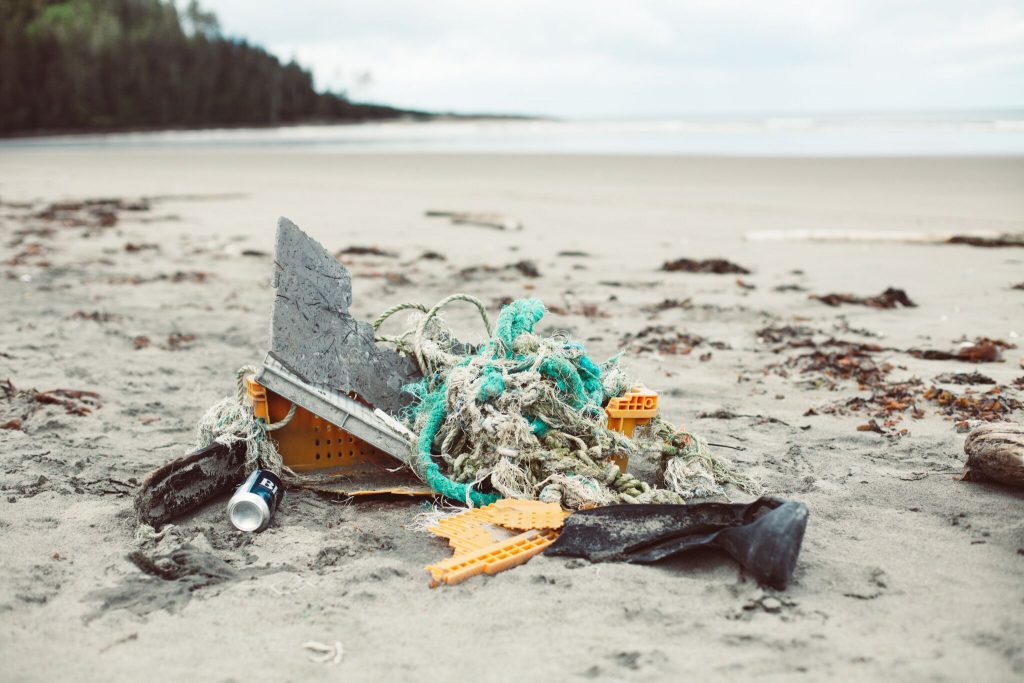
Interesting: Cigarettes account for half of waste recovered on Vancouver and Victoria shorelines – Plastic waste, particularly from smoking, still dominates litter collected from B.C. coastlines, a recent study from the University of British Columbia has found.
UBC researchers analysed data from 1,226 voluntary cleanups organized by the Great Canadian Shoreline Cleanup (GCSC), a conservation initiative of the Vancouver Aquarium and WWF-Canada, along the coast of B.C. between 2013 and 2016.
“We found that generally 80 to 90 per cent of the litter that’s being collected is still plastic waste,” said Cassandra Konecny, co-author of the study and master’s student in the department of zoology and Institute for the Oceans and Fisheries at UBC. “We also found that while the amount of trash being collected didn’t vary much over time, the type of litter varied by region.”
The waste items were grouped into categories by source – smoking, recreation, fishing, dumping and hygiene products – and then sorted by region from the north coast of B.C. down to the southern Strait of Georgia. The most common litter items in B.C. include cigarettes and filters, foam pieces, plastic pieces and food wrappers and containers.
“In places like the southern Strait of Georgia which includes larger urban areas like Vancouver and Victoria, we see that cigarettes and cigarette filters – which are made of plastic – account for almost 50 per cent of litter recovered,” said co-author Vanessa Fladmark, a master’s student in the department of earth, ocean and atmospheric sciences and Institute for the Oceans and Fisheries at UBC. “On the north coast of B.C., in places like Haida Gwaii and Prince Rupert, we see a lot more recreational items like large plastic bottles or plastic bags.”
Researchers say the findings could help guide waste management strategies across the province. “While volunteer-led conservation efforts like the Great Canadian Shoreline Cleanup are great at removing shoreline litter, more needs to be done to actually reduce the amount of litter that ends up in the water or on the coast,” said Konecny.
“For example, we’ve heard a lot recently about banning single-use plastic straws in the City of Vancouver. But if the data shows that smoking is a big issue and mostly we’re just picking up cigarettes, that’s perhaps a good place to start.”
The researchers recommend more efforts be allocated to seeking regulatory changes for the production and distribution of items commonly found on shorelines, marine pollution awareness campaigns and better waste management infrastructure.
“The GCSC dataset is a Canada-wide source that extends back to 2006 and could be used to assess the effectiveness of policy changes to reduce pollution,” said co-author Santiago De La Puente, a PhD student at the Institute for the Oceans and Fisheries at UBC. “So far, we are the first study to analyze this data and our findings could, for example, help the City of Vancouver track changes in the litter being collected on our shorelines.”
Diane Says:
Hey Glenn,
Just so you know:this morning when I wanted to read your website…
I was asked if I was the “owner” of this website and to please register.
I did not want to, so I resolved the issue by deleted your website and rebooted my phone(iPhone) and I am back to normal.
Hope this hasn’t happened to others as well.
Diane nocal
~~~ Hi Diane, we all are here together in this missing website situation! The site has come and gone, mostly gone…all day. I hope that it stays on now, although I’m not holding my breathe.
Things should be back to normal by Friday…hopefully sooner!
Sorry about this, unfortunately…it’s totally out of my hands.
Aloha, Glenn