


Air Temperatures – The following high temperatures (F) were recorded across the state of Hawaii Wednesday…along with the low temperatures Wednesday:
86 – 77 Lihue, Kauai
87 – 78 Honolulu, Oahu
87 – 77 Molokai AP
86 – 75 Kahului AP, Maui
88 – 78 Kailua Kona
85 – 71 Hilo AP, Hawaii
Here are the latest 24-hour precipitation totals (inches) for each of the islands Wednesday evening:
0.12 Puu Lua, Kauai
0.05 Waihee Pump, Oahu
0.10 Molokai
0.03 Lanai
0.01 Kahoolawe
1.72 West Wailuaiki AP, Maui
0.72 Kawainui Stream, Big Island
The following numbers represent the strongest wind gusts (mph) Wednesday evening:
35 Port Allen, Kauai
27 Kuaokala, Oahu
25 Molokai
30 Lanai
32 Kahoolawe
31 Kahului AP, Maui
33 Waikoloa, Big Island
Hawaii’s Mountains – Here’s a link to the live webcam on the summit of our tallest mountain Mauna Kea (nearly 13,800 feet high) on the Big Island of Hawaii. Here’s the webcam for the 10,000+ feet high Haleakala Crater on Maui. These webcams are available during the daylight hours here in the islands, and at night whenever there’s a big moon shining down. Also, at night you will be able to see the stars, and the sunrise and sunset too…depending upon weather conditions.
Aloha Paragraphs

The tropical waters of the central Pacific Ocean remain active (click to enlarge)


Thunderstorms to our southwest, south and southeast

Clear to partly cloudy…some cloudy areas

Showers locally and offshore – Looping image
Small Craft Advisory…windiest coasts and channels around Maui County and the Big Island
~~~ Hawaii Weather Narrative ~~~
Broad Brush Overview: A relatively dry trade wind pattern will continue through much of the weekend, into the first half of next week. Tonight through Thursday, a weak tropical low pressure system will pass through the islands elevating moisture levels, and increase shower activity some. Drier and more stable conditions will return Friday into the middle of next week, with clouds and scattered showers favoring windward and mountain areas as usual.
Details: A brief interruption to this drier spell will develop later tonight through Thursday night, as a weak tropical low drifts slowly east to west across the island chain. Thus, there will be an increase in shower activity for the islands starting tonight through Thursday night, especially in the overnight and early morning hours, with showers falling over windward and mountain slopes…along with scattered showers across leeward areas locally.
Looking Ahead: Friday through next Wednesday, drier and more stable air returns to the islands, in association with the continued trade wind weather pattern. Clouds and scattered showers will favor windward and mountain areas, with isolated showers possible over leeward sections. As far as tropical cyclone activity, it appears that the islands will remain free of trouble in that regard…although weak disturbances passing by to our south will periodically bring some showers our way.
Here’s a near real-time Wind Profile of the Pacific Ocean – along with a Closer View of the islands / Here’s the latest Weather Map / Here’s the latest Vog Forecast Animation / Here’s the Vog Information website
Marine Environmental Conditions: Surface high pressure far north of the islands will continue to produce a moderately strong trade wind flow into the weekend.
Rough, choppy trade wind swell, and small southeast and northeast swells will produce breaking waves along east facing shores. Only small swells are otherwise expected through early next week.

The moon is full tonight
World-wide Tropical Cyclone Activity
Here’s the Thursday Pacific Disaster Center (PDC) Weather Wall Presentation covering the Atlantic Ocean, Caribbean Sea…and the Gulf of Mexico
Here’s the latest Pacific Disaster Center (PDC) Weather Wall Presentation covering the Pacific and Indian Oceans, including Tropical Cyclones, 14W (Wukong), 15W (Jongdari)…and several tropical disturbances
>>> Atlantic Ocean: No active tropical cyclones
>>> Caribbean Sea: No active tropical cyclones
>>> Gulf of Mexico: No active tropical cyclones
Tropical cyclone formation is not expected during the next 5 days.
Here’s a satellite image of the Caribbean Sea…and the Gulf of Mexico
Here’s the link to the National Hurricane Center (NHC)
>>> Eastern Pacific: No active tropical cyclones
Tropical cyclone formation is not expected during the next 5 days.
1.) According to the NHC…Shower activity associated with an elongated area of low pressure located a little more than 1000 miles southwest of the southern tip of the Baja California peninsula has changed little in organization during the past several hours. However, environmental conditions are expected to support gradual development, and a tropical depression could form during the next few days while the system moves toward the west or west-northwest.
* Formation chance through 48 hours…medium…50 percent
* Formation chance through 5 days…medium…60 percent
2.) According to the NHC…Showers and thunderstorms associated with a small low pressure system are located around 1800 miles west-southwest of the southern tip of the Baja California peninsula. This system is forecast to move westward and only a small increase in organization could result in the formation of a tropical depression later today or early Friday before unfavorable upper-level winds become established over the disturbance.
* Formation chance through 48 hours…medium…50 percent
* Formation chance through 5 days…medium…50 percent
Here’s a wide satellite image that covers the entire area between Mexico, out through the central Pacific…to the International Dateline.
Here’s the link to the National Hurricane Center (NHC)
>>> Central Pacific: No active tropical cyclones
Tropical cyclone formation is not expected during the next 5 days.
1.) According to the CPHC…An area of low pressure is located about 850 miles southeast of Hilo, Hawaii. Shower and thunderstorm activity has increased around the system over the past 6 hours, but the disturbance remains disorganized. Only limited development of this area is expected due to unfavorable upper-level winds as it moves west at 10 to 15 mph during the next couple of days.
* Formation chance through 48 hours…low…10 percent
* Formation chance through 5 days…low…10 percent
Here’s a link to the Central Pacific Hurricane Center (CPHC)
>>> Northwest Pacific Ocean:
Tropical Cyclone 14W (Wukong) – Final Warning
>>> South Pacific Ocean: No active tropical cyclones
Here’s a link to the Joint Typhoon Warning Center (JTWC)
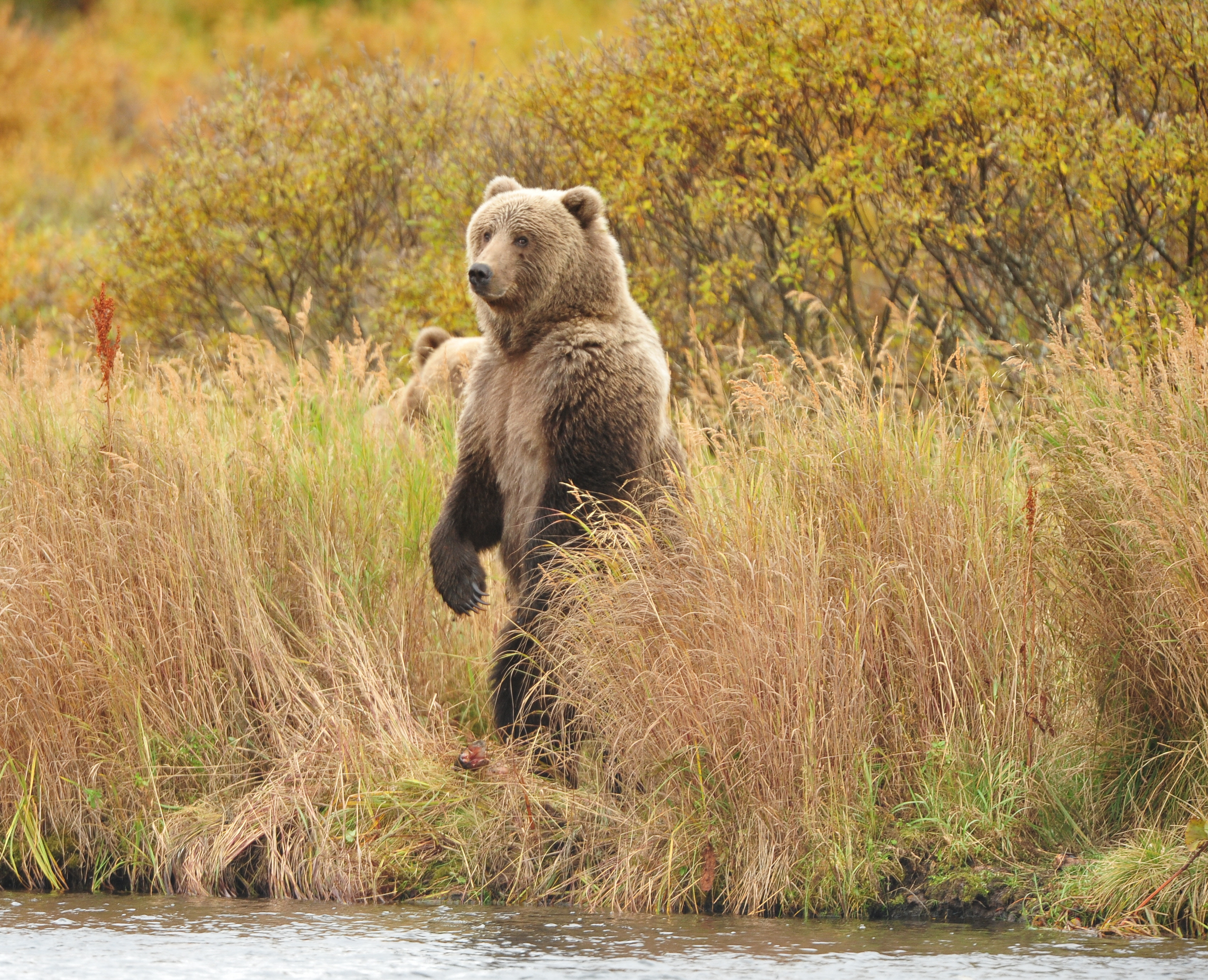
Interesting: Diverse salmon populations enable ‘resource surfing’ bears to eat tons of fish – Research shows that Kodiak brown bears that sync their stream-to-stream movements to salmon spawning patterns eat longer and more than bears that don’t, with one bear in the study consuming greater than 2 tons of fish in one summer.
Individual sockeye salmon populations spawn for about 40 days, but “resource surfing” bears can fish for three times that long, biologists have learned.
Worldwide, prolonged salmon availability is increasingly under threat from hatchery supplementation that tends to reduce the genetic diversity underpinning different spawning times. In addition, bears’ ability to follow salmon waves is hampered by industrial development such as mining.
Findings were just published in Scientific Reports.
“This study is the first to link actual metrics of bear consumption to their foraging behavior and movements,” said co-author Jonathan Armstrong, assistant professor of fisheries and wildlife in the Oregon State University College of Agricultural Sciences.
Armstrong collaborated with corresponding author Will Deacy and scientists from the University of Montana, Washington State University and the Kodiak National Wildlife Refuge to collar 33 female bears and track them for a year over a 1-million-square-kilometer portion of Kodiak Island.
At the end of those 12 months, the team recaptured 18 of the bears and took hair samples that they measured for mercury. Salmon absorb mercury from what they eat in the ocean, and the amount of mercury in a bear’s hair indicates how much fish it dined on – the more mercury, the more salmon it ate.
“Salmon consumption ranged from around 300 kilograms for one bear up to almost 2,000 kilograms for the biggest salmon eater,” said Deacy, a postdoctoral scholar at OSU. “This study complements our other research to show how bears depend on diverse salmon populations.”
On average, the bears in the study ate more than 1,000 kilograms of salmon apiece, and the more fishing sites a bear visited, the more time it spent fishing. Salmon originating from different streams return from sea to spawn at different times, making resource surfing possible.
“Results suggest that in intact watersheds with abundant salmon runs, year to year variation in salmon numbers likely has less effect on salmon consumption than individual variation in bear foraging behavior,” Deacy said. “A remaining challenge is to understand the drivers of that individual variation.”
Sandra Says:
Hey my go-to Weather Guy!! Happy Belated Birthday! We were away camping, with no access to social media. Hope the day was extra special for you, and thank you for taking the time to keep this website going! You’ve awoken a passion for weather in me, and I truly thank you for such interesting information. Stay well and youthful. Sandra J from Vanc Island
~~~ Hi Sandra, thanks for having me as your Hawaii weather Guy! Glad to hear that you had a good camping trip…that’s always fun!
I did have a great BD, as I spent it in NYC with a friend…my first time there.
You’re very welcome, I love keeping this website going, it’s fun, and it brings me a deep pleasure to do so. I’ve followed weather all my life, ever since I was something like 7 years old.
BTW, I love Vancouver Island, have visited a few times, and am looking forward to the next time I visit your great island!
Take care, and thanks for being in touch.
Aloha, Glenn
Diane Says:
Dear Glenn,
Right on…..”Interesting Article”!!!!
As a reader of your website for 10 yrs
I have benefited in so many ways.
Mahalo
Diane northern ca
Ps daughter and I just got back from the concrete jungle(Waikiki)
but our daily trips to the real jungle(no words will suffice)
The air is rich for breathing!!
~~~ Hi Diane, glad you appreciated the Interesting article, and so glad to hear you enjoyed being on Oahu as well, both the concrete side (Honolulu), and the real jungle…the windward side.
I’m happy to know you have been a regular reader for so long too…thanks!
Aloha, Glenn
Dwight Says:
Aloha Glenn,
Thank you for bringing attention to this subject of humanity transitioning from animal based foods to plant based. This may well prove to be the one most effective choice we all can make right now to reduce GHG emissions and save our planet from the effects of higher levels of carbon.
Mahalo,
Dwight
~~~ Hi Dwight, thanks for your support of the Interesting Article that I picked out today…I appreciate your letting me know. I appreciate your comment on the article as well.
Aloha, Glenn