


Air Temperatures – The following high temperatures (F) were recorded across the state of Hawaii Monday…along with the low temperatures Monday:
80 – 72 Lihue, Kauai
84 – 73 Honolulu, Oahu
82 – 73 Molokai AP
81 – 71 Kahului AP, Maui
86 – 73 Kailua Kona
81 – 67 Hilo AP, Hawaii
Here are the latest 24-hour precipitation totals (inches) for each of the islands Monday evening:
0.95 Kilohana, Kauai
0.14 Nuuanu Upper, Oahu
0.12 Molokai
0.00 Lanai
0.00 Kahoolawe
0.77 Puu Kukui, Maui
0.59 Kawainui Stream, Big Island
The following numbers represent the strongest wind gusts (mph) Monday evening:
27 Port Allen, Kauai
32 Oahu Forest NWR, Oahu
31 Molokai
31 Lanai
36 Kahoolawe
33 Maalaea Bay, Maui
42 Puu Mali, Big Island
Hawaii’s Mountains – Here’s a link to the live webcam on the summit of our tallest mountain Mauna Kea (nearly 13,800 feet high) on the Big Island of Hawaii. Here’s the webcam for the Haleakala Crater on Maui. These webcams are available during the daylight hours here in the islands, and at night whenever there’s a big moon shining down. Also, at night you will be able to see the stars — and the sunrise and sunset too — depending upon weather conditions.
Aloha Paragraphs

High pressure northeast and north-northwest of the state…keeping our trades going

Most of the high and middle clouds…are shifting to the south

Partly to mostly cloudy…clear skies locally

Showers…mostly along windward Maui and the Big Island
Looping image
~~~ Hawaii Weather Narrative ~~~
Small Craft Advisory – coasts and channels statewide
Broad Brush Overview: A moderately strong high pressure system will be passing by north of the islands, which will keep locally strong trade winds blowing over the island chain through mid-week. Moisture being carried our way on these trades, will bring increased clouds and showers to some windward and mountain areas at times this week. Trade wind speeds will gradually decline during the second half of the week, as low pressure develops to our north. A late season cold front may move down the island chain late Friday through Saturday…followed by drier and cooler northerly winds Sunday into early next week.
Details: Only minor changes in our local weather are expected through the next few days, as a trade wind weather pattern continues, and patches of increased moisture embedded in the trades move through the islands at times. Trade wind speeds should peak into Tuesday, as a high passes north of the state, with windy conditions in some areas. A few of the windier spots may reach wind advisory levels during this time. The high will then stall well to the northeast of the islands by mid-week, with trade wind speeds relaxing back to moderate levels. Showers will remain focused over windward areas, with a few showers spilling into leeward sections at times.
Looking Ahead: The models show yet another large trough and surface low developing north of the state, beginning late Thursday into the weekend. There’s some uncertainty between our two most reliable models (GFS & ECMWF), although at this point we can look for the trade winds to falter Thursday night and Friday as a cold front approaches. We could see a frontal passage through the state Saturday…with cooler and dry northerly flow in the wake of the cloud band. However, given the lateness in the season and the model uncertainty, this may or may not happen, it would be wise to stay tuned to which way this appears to be going over the next several days.
Here’s a wind profile of the Pacific Ocean – Closer view of the islands / Here’s the vog forecast animation / Here’s the latest weather map
Marine environment details: Moderate to strong trades are forecast to hold through much of this week, as high pressure remains north of the state.
Rough surf is forecast to persist through the week along east facing shores, due to strong trades holding in place locally and just upstream of the islands. The best chance for advisory level surf will come tonight through Wednesday morning as the wind speeds peak. There could be a break in the trades by Thursday and Friday…as a cold front approaches and moves into the area.
A northwest swell has begun to fill in and will continue to build down the island chain…then peak through the day. The swell will slowly lower tonight through mid-week. Surf is forecast to peak at heights below advisory levels along north and west facing shores.
A reinforcing moderate northwest swell is forecast to fill in Thursday, peak Thursday night into Friday, then lower into the weekend. Surf should remain below advisory levels along north and west facing shores.
A reinforcing southwest swell is forecast to arrive and hold through mid-week…resulting in small to moderate surf along south facing shores.

World-wide Tropical Cyclone activity
Here’s the Tuesday Pacific Disaster Center (PDC) Weather Wall Presentation, covering Tropical Cyclone Fakir, and a tropical disturbance being referred to as Invest 96S…both located in the South Indian Ocean
![]()
>>> Atlantic Ocean:
>>> Caribbean Sea:
>>> Gulf of Mexico:
Here’s a satellite image of the Caribbean Sea…and the Gulf of Mexico
Here’s the link to the National Hurricane Center (NHC)
>>> Eastern Pacific:
Here’s a wide satellite image that covers the entire area between Mexico, out through the central Pacific…to the International Dateline.
Here’s the link to the National Hurricane Center (NHC)
>>> Central Pacific:
Here’s a link to the Central Pacific Hurricane Center (CPHC)
>>> Northwest Pacific Ocean: No active tropical cyclones
Tropical Cyclone 20S (Fakir)
JTWC textual forecast warning
JTWC graphical track map
NOAA satellite image
>>> North and South Indian Oceans / Arabian Sea: No active tropical cyclones
Here’s a link to the Joint Typhoon Warning Center (JTWC)
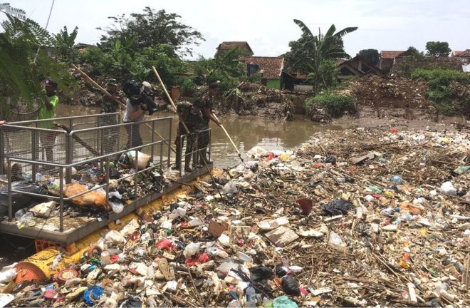
Interesting: Giant plastic ‘berg blocks Indonesian river – A crisis of plastic waste in Indonesia has become so acute that the army has been called in to help.
Rivers and canals are clogged with dense masses of bottles, bags and other plastic packaging.
Officials say they are engaged in a “battle” against waste that accumulates as quickly as they clear it.
The commander of a military unit in the city of Bandung described it as “our biggest enemy”.
Like many rapidly developing countries, Indonesia has become notorious for struggling to cope with mountains of rubbish.
A population boom has combined with an explosive spread of plastic containers and wrapping replacing natural biodegradable packaging such as banana leaves.
The result is that local authorities trying to provide rubbish collection have been unable to keep up with the dramatic expansion of waste generated.
And a longstanding culture of throwing rubbish into ditches and streams has meant that any attempt to clean up needs a massive shift in public opinion.
‘Shocking sight’
In Bandung, Indonesia’s third largest city, the shocking sight of a concentration of plastic waste so thick that it looked like an iceberg and blocked a major tributary.
Soldiers deployed on a barge used nets to try to extract bags, Styrofoam food boxes and bottles, a seemingly futile task because all the time more plastic flowed their way from further upstream.
The senior official in charge, Dr Anang Sudarna, who heads the West Java Environmental Protection Agency, said that the problem was “impossible to sort out without the highest authority”.
That’s why he took the drastic step of appealing to the Indonesian president to send in the army, and the move has made some difference, according to Dr. Sudarna.
“The result is a little bit improved…although I am angry, I am sad, I am trying to think how best to solve this… the most difficult thing is the people’s attitude and the political will.”
Frontal assault
For Sergeant Sugito, commanding an army unit, the assignment was new and unusual and “not as easy as flipping your hand”.
“My current enemy is not a combat enemy, what I am fighting very hard now is rubbish, it is our biggest enemy.”
But he also said that plastic should be recognized as valuable – “for example, plastic cartons and drinking bottles can be separated from the other rubbish and sold”, he said.
Encouraging people to see plastic as a resource is a key step towards finding a solution to the crisis.
To encourage recycling, the authorities in the Bandung area are supporting initiatives in “eco-villages” where residents can bring old plastic items and earn small amounts of money in exchange.
The plastics are then divided by type. In one project, two women patiently cut apart bottles and small water cups because separating the different kinds of polymers earns higher prices.
Officials are optimistic that word will spread that plastic has value – and raise awareness of the plastic waste problem – but they also admit privately that many residents are either uninterested or cannot see the point.
Meanwhile, on Bandung’s only landfill site – which receives only a fraction of the waste the city produces – an unofficial form of recycling is under way.
Next generation
On a hillside buried in rubbish, amid an overwhelming stench in the tropical heat, 500 so-called “scavengers” search each new load of rubbish for plastic products.
When I asked one man, scrambling from the path of an excavator, what he was looking for, he reached into a bag and held up a plastic bottle.
The work is punishing but generates income which supports entire families living on the dump, and it also demonstrates that there is a market for recycled plastic and more could be done to serve it.
For one activist working to change attitudes, Mohamad Bijaksana Junerosano of Greeneration, the solution has to involve law enforcement, education and social awareness.
Investment was needed to teach children about waste and recycling, he said, but that had to be done in combination with improvements in public attitudes.
“If we educate the student, when they go outside the school and the ecosystem is still broken and people are littering everywhere, they are confused so it needs both sides, education and also law enforcement by society.”
Monumental scale
A Dutch environmental scientist, Prof Ad Ragas of Radboud University, with long experience of Indonesia’s plastic problem, told me he has detected an important shift in the authorities.
Two years ago, when he organized a workshop on plastic pollution in Bandung, “government officials didn’t seem to care about it, they didn’t see it as a really big problem”.
By contrast, at another workshop held last month, “it’s changed dramatically”.
Social media, rapidly conveying images of choked waterways, had made a difference to people, he said.
“They immediately see that ‘this is what my river look likes now and I’m doing that because I’m throwing all this plastic away’ so they get feedback much quicker than they used to.”
But the challenge is not only monumental in scale; it is also constant.
The soldiers we filmed had planned to load the plastic onto trucks but because the vehicles never arrived they decided on a different course of action: to use a digger to push the waste downstream.
I asked the sergeant what would happen to it. It was up to another unit to collect, he said. It became someone else’s problem.
Near the coast, just outside the capital Jakarta, we came across a canal that was totally blocked with plastic. Local residents complained that whenever they tried to clear it, more arrived from upstream, as in Bandung.
Most apocalyptic of all was the scene at a fishing village on the coast itself. The mud of the shoreline was completely hidden by a thick layer of plastic waste stretching over hundreds of meters.
On a walkway crossing over the sea of plastic was a small girl playing with a balloon. By the time Indonesia’s plastic nightmare is sorted, she may well have grown up.
Rick Says:
Glenn, studied the forecast for the month leading in to our arrival this week. Seems we got lucky. Busted a move from the Maui Kai down to Makena today, and has been the case for the last 3 visits, a major cloud just hung at the beach. What gives? Love Big Beach, but am 1-4 in going. Literally a big cloud just hung over the beach area and seemingly the rest of the state had sun. Slight exaggeration.
Mahalo, and go Cubs.
~~~ Hi Rick, yep, that happens over the Makena area quite often. The simple answer is that the trade winds converge in that area. One arm of the trades come around the back side of east Maui, and then run up against the trades coming through the central Valley…and along the Kihei coast to Makena. These clouds can drop showers at times too. Makena is such a lovely stretch of sand, and can have fun surf at times too. The down side can be those afternoon clouds that hang over that area…as you point out.
Aloha, Glenn
Dana Says:
Aloha Glenn,
Tonight is our last night in paradise 🙁
We fly back to Canada tomorrow. Thank you for you always wonderful
and precise weather forecasts! I have followed your website for several
years now 🙂 I love checking in on the weather in paradise as we are getting
pelted with snow.. also to check in on what our weather will be like when
We are lucky enough to return 🙂
Until next time…
Mahalo
Dana
~~~ Hi Dana, I’m so happy that you have had a wonderful vacation!
Thanks for your sincere and positive feedback about my website…I’m very appreciative.
Have a smooth trip back to Canada, the weather there should be grading quickly back towards a warmer spring reality.
We’ll look forward to having you back here in paradise next time!
Aloha, Glenn