


Air Temperatures – The following high temperatures (F) were recorded across the state of Hawaii Tuesday…along with the low temperatures Tuesday:
78 – 68 Lihue, Kauai
79 – 64 Honolulu, Oahu
80 – 62 Kahului AP, Maui
82 – 67 Kailua Kona
84 – 66 Hilo AP, Hawaii
Here are the latest 24-hour precipitation totals (inches) for each of the islands Tuesday evening:
11.06 Kilohana, Kauai
2.89 Hawaii Kai, Oahu
0.33 Molokai
0.47 Lanai
0.48 Kahoolawe
1.59 Maalaea Bay, Maui
1.62 Waikoloa, Big Island
The following numbers represent the strongest wind gusts (mph) Tuesday evening:
17 Mana, Kauai
18 Oahu Forest NWR, Oahu
13 Molokai
08 Lanai
18 Kahoolawe
22 Maalaea Bay, Maui
21 PTA Kipuka Alala, Big Island
Hawaii’s Mountains – Here’s a link to the live webcam on the summit of our tallest mountain Mauna Kea (nearly 13,800 feet high) on the Big Island of Hawaii. Here’s the webcam for the Haleakala Crater on Maui. These webcams are available during the daylight hours here in the islands, and at night whenever there’s a big moon shining down. Also, at night you will be able to see the stars — and the sunrise and sunset too — depending upon weather conditions.
Aloha Paragraphs

A cold front and trough aloft is keeping unsettled weather in place

Unsettled weather remains over some parts of the state

Deep clouds locally…with embedded thunderstorms

Showers locally..some are heavy
Looping image
~~~ Hawaii Weather Narrative ~~~
Flash Flood Watch…Niihau, Kauai, Oahu, Maui County and the Big Island
Broad Brush Overview: A winter cold front will migrate slowly eastward, while a trough of low pressure in the upper atmosphere, will keep Hawaii’s atmosphere unstable into mid-week. Heavy showers and thunderstorms are possible across the island chain, with gusty winds and frequent lightning associated with the strongest thunderstorms. Drier and more settled weather is expected Thursday through the weekend…as the trade winds finally reappear.
Details: This cold front has joined forces with a trough aloft, and heavy showers and strong thunderstorms are active over the eastern islands as a result. A post-frontal northwest to northerly air flow is spreading over Kauai and Oahu, although instability provided by the trough aloft, continues to fuel locally heavy showers locally. To the east of the front, the atmosphere remains ripe for development of strong to severe thunderstorms…capable of producing gusty winds and hail. Meanwhile, deep moisture and cold temperatures aloft over the Big Island are bringing winter weather to the summits.
Looking Further Ahead: The models show the front pushing slowly east past the Big Island. While most of the associated deep moisture is expected to move east of the islands as this occurs, low pressure aloft is expected to support a very unstable island atmosphere. A light and variable wind flow statewide is expected to favor a northerly direction on Kauai and Oahu, as high pressure begins to arrive from the northwest. These light winds will allow sea breezes to converge over the islands through Wednesday, potentially leading to localized downpours in some areas.
So despite gradually drying air, the Flash Flood Watch for all islands will remain active, as any showers that develop will have the potential to drop very heavy rain in a short period of time. A very weak and shallow front moving through Wednesday night and Thursday will finally bring a cool, dry and stable air mass over the islands. These cooler north winds Thursday will veer to the typical trade wind direction Friday…with light to moderate trades generally expected during the weekend time frame. Should I say unfortunately, the models are hinting at a return of wet weather early next week.
Here’s a wind profile of the Pacific Ocean – Closer view of the islands / Here’s the vog forecast animation / Here’s the latest weather map
Marine environment details: A slow moving cold front over the central islands is keeping a weak pressure gradient and light winds over most waters. The front will shift slowly east over the next couple of days. Light winds are expected to persist in most of the local marine areas through Wednesday, though some moderate northerlies are expected near Kauai. High pressure will build northwest of the islands Wednesday night, causing increasing northerlies near Kauai and Oahu. Stronger north to northeast winds will then overspread the state Thursday and Thursday night. Trade winds may reach Small Craft Advisory (SCA) levels in the typically windier waters by Thursday night or Friday.
A moist and unstable airmass associated with the front and a strong trough aloft will maintain the chance for thunderstorms, with locally higher winds and seas, reduced visibility in heavy downpours…and cloud to surface lightning through Wednesday.
Guidance continues to indicate a large northwest swell spreading across the state late Thursday through Friday. The swell should peak near warning levels for north and west facing shores, and will likely result in a SCA due to elevated seas across exposed waters late Thursday through Friday night.

Heavy rain mostly offshore to the northeast of Maui and the Big Island
World-wide Tropical Cyclone activity
>>> Here’s the latest PDC Weather Wall Presentation, covering Tropical Cyclone 07S (Cebile) in the South Indian Ocean, and a tropical disturbance being referred to as Invest 93W well southeast of Guam in the western Pacific Ocean…and finally a second tropical disturbance called Invest 97P
![]()
>>> Atlantic Ocean:
>>> Caribbean Sea:
>>> Gulf of Mexico:
Here’s a satellite image of the Caribbean Sea…and the Gulf of Mexico
Here’s the link to the National Hurricane Center (NHC)
>>> Eastern Pacific:
Here’s a wide satellite image that covers the entire area between Mexico, out through the central Pacific…to the International Dateline.
Here’s the link to the National Hurricane Center (NHC)
>>> Central Pacific:
Here’s a link to the Central Pacific Hurricane Center (CPHC)
>>> Northwest Pacific Ocean: No active tropical cyclones
>>> North and South Indian Oceans / Arabian Sea:
Tropical Cyclone 07S (Cebile)
JTWC textual forecast warning
JTWC graphical track map
NOAA satellite image
Here’s a link to the Joint Typhoon Warning Center (JTWC)
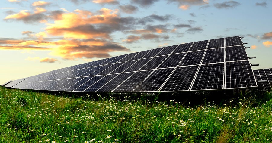
Interesting: Farm Sunshine, Not Cancer: Replacing Tobacco Fields with Solar Arrays – Michigan Tech researchers contend that tobacco farmers could increase profits by converting their land to solar farms, which in turn provides renewable energy generation.
Although tobacco use is the leading cause of avoidable death globally, farming tobacco continues to provide the primary source of income to many farmers. But two Michigan Technological University researchers contend that converting tobacco fields to solar farms could profitably serve two purposes: Reduce preventable deaths and meet the growing need for solar energy to combat climate change.
Ram Krishnan, now an engineer designing large solar systems in the rapidly expanding U.S. solar industry, and Joshua Pearce, professor of materials science and electrical engineering, completed a study “Economic Impact of Substituting Solar Photovoltaic Electric Production for Tobacco Farming”.
As demand for solar energy grows so does the demand for land for solar farms. “To completely eliminate the need for burning fossil fuels, solar technology requires large surface areas,” Pearce explains.
However, as demonstrated by the conversion of cropland to energy for ethanol production, removing arable land from food production can cause a rise in global food prices and food shortages. Targeting land that grows crops with known health hazards for solar energy production removes a detrimental consequence from the equation, the researchers say, and the potential to convert tobacco fields to solar arrays could provide a tantalizing opportunity for farmers to increase their profits thousands of dollars per acre per year by transitioning from tobacco to solar.
Here Comes the Sun
Krishnan and Pearce selected North Carolina for their case study because it is a major tobacco-producing state with large swaths of land and high solar potential.
Tobacco crop lands provided an interesting opportunity because tobacco use in America is declining and has well-documented bad impacts on human health. Pearce notes that tobacco continues to be farmed in the U.S. today because farmers can make money doing it.
“We were interested in what conditions were needed to enable tobacco farmers to begin installing solar energy systems on the same land,” he says. “We looked at likely trends in all of the major economic factors, but were surprised to find that because the cost of solar has dropped so dramatically it is already economically advantageous for tobacco farmers to replace tobacco with solar in many situations.”
Additionally, unlike plants, solar modules can withstand extreme heat, cold, ice, snow, hail, torrential rain, droughts and other increasingly unstable climate conditions. They are rated to withstand winds upwards of 150 miles per hour.
Energy of the Future
Krishnan and Pearce conducted a sensitivity analysis on the economic factors of the installed solar farms and their effects on profit. They compared solar profit and the profit available for simply farming tobacco per acre per year.
They used conservative positive assumptions on tobacco crop yield and price, noting there could also be a decrease in demand for tobacco as fewer people take up smoking and existing smokers die. They then looked at how much the price of electricity could increase each year based on a range of past increases (called the escalation rate, which ranged from 0.3 percent in 2010 value to 5.7 percent in 2008 value). As electricity becomes more valuable because of a higher escalation rate, solar energy produced in the future becomes more valuable. Even with relatively modest escalation rates, solar electricity provides tremendous profits of thousands of dollars to tens of thousands of dollars more per acre per year for land owners.
Escalation rates and the associated value of electricity in the future are presented in the paper over a wide range. Similarly, calculations for the costs of the solar installation varied from two dollars per watt (expensive in today’s market in which solar farms have come in at one dollar per watt) to realistic potential reduced costs in the future of 80 cents per watt. The sensitivity analysis presented in the paper allows farmers to make their own educated guesses on inputs based on what their local utility’s electric rates and what price the farmers are quoted for a photovoltaic farm on their land, then make the decision that makes the most sense for them. To determine whether a solar photovoltaic farm would work on their land, tobacco farmers should calculate the LCOE (levelized cost of electricity) for their solar farm and compare it to the price of electricity in their particular location, rate structure, and load, as well as economic factors.
Providing Energy, Saving Lives
If every tobacco farm in North Carolina converted to solar energy production, there is the potential to generate 30 gigawatts, which is equivalent to the state’s peak summer load. In the long run, tobacco farmers stand to make more money farming solar rays for energy instead of growing a component of cigarettes.
The primary reason holding back tobacco farmers is the capital cost of the solar system. Currently, a 10-megawatt solar farm priced at $1 per watt to install—$10 million. To help farmers make such a conversion, Pearce argues, governments in tobacco states should begin exploring policies to ease the transition. Many tobacco farmers would need to rely on investors to deploy solar. Local governments could also aid the transition by making policies to help provide access to the needed capital to help land owners transition.
In addition to the economic and environmental benefits, the researchers estimate conversion of North Carolina’s tobacco fields would save 2,000 American lives per year from pollution reduction alone by offsetting coal-powered electricity.
Based on numbers from the Centers for Disease Control, if all tobacco use is eliminated by replacing tobacco farms in the U.S. with solar farms, more than 480,000 American deaths per year from cigarette smoking are directly saved. In addition, 42,000 deaths resulting from Americans suffering the effects secondhand smoke would also be saved per year.
All together this represents a total of over half a million premature deaths prevented in the U.S. directly every year.
“The economic benefits for ex-tobacco farmers going into solar is nice,” Pearce concludes, “but the real payoff is in American lives saved from both pollution prevention and smoking cessation.”
Sharon Charlton Says:
Aloha Glenn. As we prepare to depart Maui tomorrow (for the -30 degree temps of Saskatchewan Canada) I’d like to thank you for your dedication to writing consise, informative and interesting reports. you are my go-to for all things weather here on the islands!
The rains over the past couple of days have been incredible. Wow.
Warm aloha
Sharon Charlton
~~~ Hi Sharon, it sounds like you greatly enjoyed Maui, despite the inclement weather of late…good for you! I know it’s been raining quite a bit, with even those thunderstorms and flooding issue at times too.
I greatly appreciate your very kind and generous words of praise, and believe me…I take them to heart.
It sounds very cold in your home town there in CA, dress warmly of course…and don’t forget spring is right around the corner.
Hurry back!
Aloha, Glenn