


Air Temperatures – The following high temperatures (F) were recorded across the state of Hawaii Monday…along with the low temperatures Christmas morning:
73 – 61 Lihue, Kauai – broke the low max record for the date Monday…which was 74 in 1984
83 – 68 Honolulu, Oahu
78 – 67 Molokai
82 – 67 Kahului AP, Maui
79 – 65 Kailua Kona
78 – 62 Hilo AP, Hawaii
Here are the latest 24-hour precipitation totals (inches) for each of the islands as of Christmas evening:
0.64 Princeville AP, Kauai
0.03 Tunnel RG, Oahu
0.26 Molokai
0.00 Lanai
0.00 Kahoolawe
0.23 West Wailuaiki, Maui
0.03 Kawainui Stream, Big Island
The following numbers represent the strongest wind gusts (mph) as of Christmas evening:
20 Port Allen, Kauai
18 Oahu Forest NWR, Oahu
21 Molokai
20 Lanai
27 Kahoolawe
22 Maalaea Bay, Maui
30 Kealakomo, Big Island
Hawaii’s Mountains – Here’s a link to the live webcam on the summit of our tallest mountain Mauna Kea (nearly 13,800 feet high) on the Big Island of Hawaii. Here’s the webcam for the Haleakala Crater on Maui. These webcams are available during the daylight hours here in the islands, and at night whenever there’s a big moon shining down. Also, at night you will be able to see the stars — and the sunrise and sunset too — depending upon weather conditions.
Aloha Paragraphs

A storm well north…with the next cold front northwest

Heavy weather approaching from the northwest

Thunderstorms not far northwest of Kauai

Showers locally…some are heavy – Looping image
High Surf Advisory…east shores of Kauai, Oahu, Molokai, Maui and the Big Island
Wind Advisory…Big Island summits /40-50 with gusts to 60 mph
~~~ Hawaii Weather Narrative ~~~
New Year’s Eve/Day forecast: Trade winds…windward showers
Broad Brush Overview: Only a few showers are expected, falling mostly along the windward sides. Unsettled weather will then move into the islands Tuesday and continue through Wednesday, as a low passes by to the north of the islands…and a cold front approaches from the west. This front will bring southerly Kona winds, increasing clouds, along with showers and thunderstorms to the state. Conditions will improve from west to east across the island chain Wednesday and Wednesday night, as the cold front shifts eastward across the island chain. More typical trade wind weather will then build into the area by the end of the work week into the weekend, with showers focusing primarily over windward and mountain areas.
Details: Relatively dry air remains over the state, with the weak cold front stalling over Kauai…before lifting back north of the state. The best chances for rain will remain confined to windward areas of Kauai, with nothing more than a few windward showers expected otherwise. Fairly dry conditions are expected across the entire state tonight, although there will likely be an increase in windward showers for those areas exposed to the easterly and southeasterly flow. The moisture associated with the approaching storm will remain west of the state through early Tuesday.
Deep tropical moisture will increase on the Kona winds Tuesday, increasing showers particularly over Kauai and Oahu. The plume of deeper moisture will remain over the western islands Tuesday night, although also increase over Maui County as well. A trailing band of clouds and showers associated with the cold front will keep conditions somewhat unsettled across Oahu and Maui County Wednesday, with showers developing over the Big Island as well. Meanwhile, improving conditions are expected over Kauai on Wednesday behind the front.
In addition, the deep moisture associated with an upper level trough, will lead to thunderstorm development across the western and central islands Tuesday through Tuesday night. The atmosphere will be ripe for a band of strong to severe thunderstorms moving through the islands, with the best chances expected from Kauai eastward to Maui County. The main hazards from these thunderstorms are expected to be damaging winds and localized hail. Much will depend on the location and intensity of the surface low passing by to the north of the state…stay tuned.
Looking Further Ahead: The models are suggesting more settled weather will overspread the island chain, as high pressure builds in to the north of the state, and the cold front continues to shift eastward and away from the area by Thursday. Moderately strong and fairly cool north-northeasterly winds are expected in the wake of the front, with moderate trades then returning Friday through the upcoming weekend. More typical trade wind weather is expected statewide, with showers favoring windward and mountain areas through New Year’s Day.
Here’s a wind profile of the Pacific Ocean – Closer view of the islands / Here’s the vog forecast animation / Here’s the latest weather map
Marine environment details: Observations from National Data Buoy Center indicate a reinforcing north-northwest swell has arrived. The Hanalei Buoy near Kauai is also showing forerunners from this new swell. A High Surf Advisory has been issued for north and west facing shores of Niihau and Kauai, and for the north facing shores of Oahu, Molokai, and Maui…continuing through tonight. This swell is forecast to gradually lower, and shift to a more northerly direction by early Tuesday. Therefore, surf is expected to drop below the High Surf Advisory criteria some time Tuesday.
A gale low will move to a position north of the state around Wednesday. This will likely cause a large north swell to spread down across the islands, which would likely require a High Surf Advisory for most north facing shores starting late Wednesday night or Thursday. In addition, combined seas may be near the SCA criteria, especially over the waters north of Kauai and Oahu. This north swell will gradually subside by Friday.
Moderate west to northwest winds will spread down the island chain, followed by moderate north to northeast winds toward the end of the work week.
Most south facing shores may have a slight rise in surf starting around mid-week due to small out of season south-southwest and southwest swells.

World-wide Tropical Cyclone activity
>>> Here’s the latest PDC Weather Wall Presentation, covering Tropical Depression 33W (Tembin)
![]()
>>> Atlantic Ocean:
>>> Caribbean Sea:
>>> Gulf of Mexico:
Here’s a satellite image of the Caribbean Sea…and the Gulf of Mexico
Here’s the link to the National Hurricane Center (NHC)
>>> Eastern Pacific:
Here’s a wide satellite image that covers the entire area between Mexico, out through the central Pacific…to the International Dateline.
Here’s the link to the National Hurricane Center (NHC)
>>> Central Pacific:
Here’s a link to the Central Pacific Hurricane Center (CPHC)
>>> Northwest Pacific Ocean:
Tropical Depression 33W (Tembin) remains active, here’s a graphical track map…and a satellite image
>>> North and South Indian Oceans / Arabian Sea: No active tropical cyclones
Here’s a link to the Joint Typhoon Warning Center (JTWC)
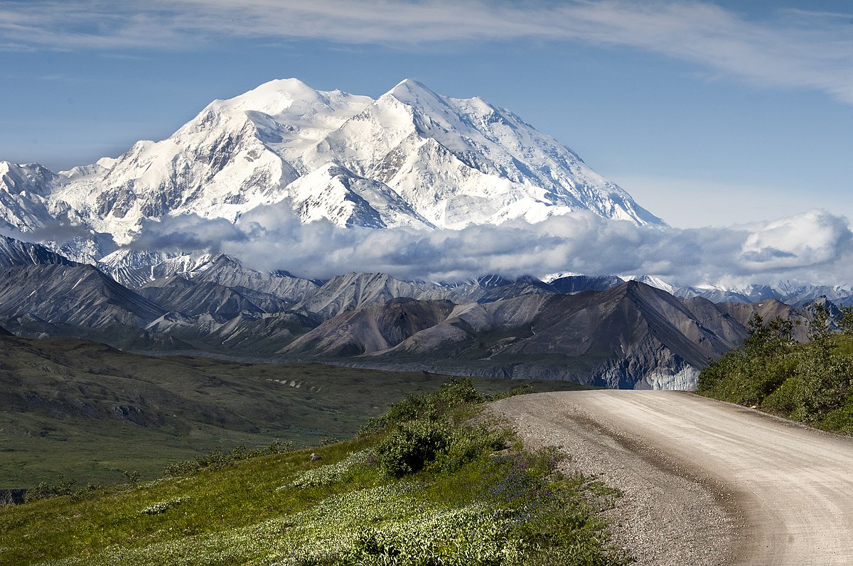
Interesting: Climate Change Has Doubled Snowfall Around North America’s Highest Peak – The amount of snow falling in Alaska’s Denali National Park, home to North America’s tallest mountain, has more than doubled over the past 150 years, according to a new study.
Scientists conducting the research near 20,310-foot Denali (formerly Mt. McKinley) say that an increase in annual snowfall from roughly 8 feet before the Industrial Revolution to 18 feet today is the result of a warming climate as more precipitation falls on the high peaks of the Alaska Range.
Researchers from Dartmouth College, the University of New Hampshire, and the University of Maine at Orono set up a camp at 13,000 feet on Mt. Hunter, near Denali. They then drilled two ice cores that contained records of snowfall dating back 1,200 years. The cores revealed a 117 percent jump in wintertime snowfall on Mt. Hunter since the mid-19th century.
“We were shocked when we first saw how much snowfall has increased,” Eric Osterberg, an assistant professor of earth sciences at Dartmouth and the study’s lead investigator, said in a statement. “We had to check and double-check our results to make sure of the findings.”
The study, published this week in the journal Scientific Reports, attributed the dramatic increase in snowfall to two principal factors: An increase in precipitation as a warming atmosphere holds more moisture, and a warming-related shift in atmospheric patterns that has channeled more Pacific storms over Alaska. The researchers noted that despite an increase in snowfall at high elevations in portions of Alaska, the state’s glaciers continue to retreat at a rapid rate because temperatures at lower elevations are rising so quickly.
Helen Says:
Merry Christmas Glenn to you and your mom !! I hope you are having a wonderful day. It is still quite brisk here @ 56 degrees on the lanai!!
~~~ Hi Helen, thank you…yes I’m here in Long Beach with my Mom for Christmas.
My neighbors in upper Kula told me this morning, that it was yet another chilly start to the day.
Merry Christmas!
Aloha, Glenn