


Air Temperatures – The following high temperatures (F) were recorded across the state of Hawaii Sunday…along with the low temperatures Sunday:
88 – 75 Lihue, Kauai
89 – 74 Honolulu, Oahu
87 – 71 Molokai
91 – 70 Kahului AP, Maui – record high temperature Sunday was 93…back in1984
87 – 77 Kailua Kona
83 – 70 Hilo AP, Hawaii
Here are the latest 24-hour precipitation totals (inches) for each of the islands as of Sunday evening:
1.16 Mount Waialeale, Kauai
0.59 Ahuimanu Loop, Oahu
0.01 Molokai
0.71 Lanai
0.00 Kahoolawe
0.45 West Wailuaiki, Maui
2.01 Kealakekua, Big Island
The following numbers represent the strongest wind gusts (mph) as of Sunday evening:
15 Port Allen, Kauai
20 Oahu Forest NWR, Oahu
21 Molokai
17 Lanai
28 Kahoolawe
25 Maalaea Bay, Maui
22 South Point, Big Island
Hawaii’s Mountains – Here’s a link to the live webcam on the summit of our tallest mountain Mauna Kea (nearly 13,800 feet high) on the Big Island of Hawaii. This webcam is available during the daylight hours here in the islands, and at night whenever there’s a big moon shining down. Also, at night you will be able to see the stars — and the sunrise and sunset too — depending upon weather conditions.
Aloha Paragraphs

A cold front is north of the islands

Thunderstorms in several directions…mostly in the deeper tropics
Windward clouds mostly

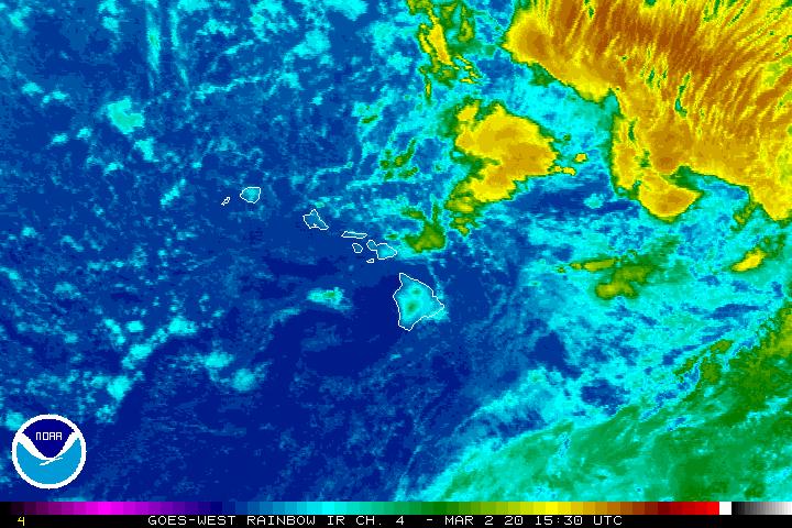
Showers locally – Looping radar image
~~~ Hawaii Weather Narrative ~~~
Broad Brush Overview: Our late summer trades will shift to lighter southeast and southerlies by Tuesday, and continue through mid-week…with trades returning during the second half of the new week. The winds will be light enough for sea breezes to prevail during the days, with some scattered afternoon showers over upcountry leeward areas. As usual, the offshore flowing land breezes will clear out most clouds and showers during the night.
Details: Meanwhile, an early season cold front is located northwest of the islands, with a high pressure ridge between the islands and this frontal boundary. These two weather features will drop south over the next few days. The ridge will stall just north of the islands, while the front will come to a halt over the northern offshore waters…dissipating there during the mid-week period.
A deepening trough of low pressure just west of Kauai, will shift eastward through mid-week. The presence of this trough has brought some briefly heavy showers across some parts of the state and offshore. Thus, we should see more of this activity, with even a possible thunderstorm over the next couple of afternoons through Wednesday…as this upper trough remains in our general vicinity.
Looking ahead: The models go on to suggest the trade winds may not return until later Thursday or Friday, into next weekend. Thus, the light winds and sultry weather will hold on through at least mid-week. As the trades return, the focus for showers will migrate back over to the windward sides then. Meanwhile, in spite of all the tropical cyclone action in the Atlantic, the Caribbean, and the Gulf of Mexico…the Central Pacific remains quiet for the time being.
Here’s a wind profile of the Pacific Ocean – Closer view of the islands / Here’s the vog forecast animation / Here’s the latest weather map
Marine environment details: Trades are forecast to weaken during the next few days, as a cold front approaches the region from the northwest. This will allow land and sea breezes to develop beginning this afternoon, with a similar pattern continuing through mid-week…with winds across the coastal waters remaining below Small Craft Advisory levels. Surf along east facing shores will trend down today as the trades relax locally and upstream of the state.
Surf along north facing shores will remain a bit elevated, although well below advisory level today due to overlapping north and northwest swells…lowering Monday. Another small northerly swell should reach the waters Tuesday, then hold through mid-week before slowly trending down. Surf from this source will remain small along north facing shores.
Surf along south facing shores will remain small through early this week with a small southeast swell holding through the next couple of days. A small to moderate southwest swell that was generated in the Tasman Sea, and will arrive around Wednesday…leading to a slight increase in surf through the second half of the week along south facing shores.

Weee!
World-wide tropical cyclone activity
>>> Here’s the latest PDC Weather Wall Presentation, covering Tropical Storm Irma, which heading north over Florida towards Georgia, and Hurricane Jose is located offshore to the north of the Caribbean Islands…as a Category 3 storm
![]()
>>> Atlantic Ocean:
Hurricane 12L (Jose) is active at the major Category 2 level, here’s a NHC graphical track map, a satellite image…and what the computer models are showing
1.) A tropical wave located several hundred miles west-southwest of the Cabo Verde Islands continues to produce disorganized showers and thunderstorms. Some development of this system is possible during the next couple of days before upper-level winds become unfavorable for tropical cyclone formation. This system is expected to move west-northwestward for the next two days and then turn northward over the central Atlantic.
* Formation chance through 48 hours…low…30 percent
* Formation chance through 5 days…low…30 percent
>>> Caribbean Sea: No active tropical cyclones
>>> Gulf of Mexico:
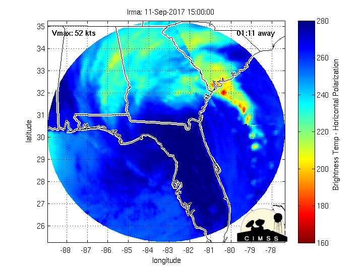
Tropical Storm 11L (Irma) is still active, here’s a NHC graphical track map, a satellite image…and what the computer models are showing
Here’s the NWS Radar Image from Tampa, Florida
Here’s a satellite image of this storm, with the looping version…along with what the computer models are showing
Long term animation…showing the storm moving through Florida
Here’s a satellite image of the Caribbean Sea…and the Gulf of Mexico
Here’s the link to the National Hurricane Center (NHC)
>>> Eastern Pacific: No active tropical cyclones
1.) The remnants of Katia located about 350 miles west-southwest of Manzanillo, Mexico are associated with a low pressure center with numerous showers and thunderstorms. Strong upper-level winds should limit development of this system while it moves westward at 10 to 15 mph during the next couple of days.
* Formation chance through 48 hours…low…30 percent
* Formation chance through 5 days…low…30 percent
2.) A trough of low pressure located a few hundred miles south of the southern coast of Mexico is producing disorganized showers and thunderstorms. Environmental conditions are expected to be conducive for development, and a tropical depression is likely to form later this week while the system moves slowly northwestward.
* Formation chance through 48 hours…low…20 percent
* Formation chance through 5 days…high…70 percent
3.) Another area of low pressure is expected to form several hundred miles south-southwest of the Baja California peninsula by the middle of the week. Environmental conditions are expected to be conducive for gradual development after that time while it moves northward or northwestward.
* Formation chance through 48 hours…low…near 0 percent
* Formation chance through 5 days…medium…60 percent
Here’s a wide satellite image that covers the entire area between Mexico, out through the central Pacific…to the International Dateline.
Here’s the link to the National Hurricane Center (NHC)
>>> Central Pacific: No active tropical cyclones
Here’s a link to the Central Pacific Hurricane Center (CPHC)
>>> Northwest Pacific Ocean:
Tropical Storm 20W (Talim) is active, here’s a JTWC graphical track map, a satellite image…and what the computer models are showing
>>> North and South Indian Oceans / Arabian Sea: No active tropical cyclones
Here’s a link to the Joint Typhoon Warning Center (JTWC)
Interesting: Hurricanes Normally Peak Today – For those on the East Coast, today is statistically the most likely day to get the rain boots out, check the emergency food stash and make sure the candles are well-stocked.
September 10 is the peak day for hurricane activity along the U.S. Atlantic coast, as a result of a confluence of factors, from winds, to atmospheric pressure to ocean water temperature, according to the National Atmospheric and Oceanic Administration. And this year at least, peak hurricane day is living up to its hype: Two Category 4 hurricanes, Hurricane Irma and Hurricane Jose, are currently roiling the Atlantic. Hurricane Irma is currently battering parts of the Florida Keys and is set to make landfall in Florida soon.
The reason for this year’s busy September 10 is a combination of light winds off the Atlantic, high moisture in the atmosphere, bathtub-warm waters in the Atlantic Ocean, experts say.
While September 10 is statistically the most likely day to have active hurricanes, that doesn’t mean a nasty storm is always in store for the Atlantic coast on this day every year.
“The tropical activity is usually greatest on average on that day,” said Neal Dorst, a researcher with the NOAA Atlantic Oceanographic and Meteorological Laboratory Hurricane Research Division. “But your mileage may vary. From one year to the next, there is no guarantee that there will be a hurricane on Sept. 10, only that it is the most likely on that day.”
Mixture of factors
Multiple factors affect the risk of a hurricane forming. For instance, around this time of the year, the subtropical ridge, a belt of high atmospheric pressure that usually sits above the mid-latitudes, has migrated northward. It has migrated far enough north that it allows tropical disturbances, or slight air circulation regions that center around the trade winds, to move across the deep tropical Atlantic Ocean.
At the same time, there is little vertical wind shear, Dorst said. Vertical wind shear, or the change in wind speed with height in the atmosphere, takes the oomph out of a building hurricane by transporting heat and moisture from its center and by tilting its vortex, which makes it less efficient at generating heat, according to Weather Underground. With low shear, there is little to blunt the buildup of heat and moisture needed to fuel a hurricane.
The sun’s rays have also warmed the deep tropical waters off the Atlantic during this period, while air temperatures rise as well. At the same time, the middle levels of the atmosphere are chock-full of moisture, the perfect fuel for wet, gusty hurricanes, Dorst said. All these factors are likeliest to line up today, according to NOAA’s weather models.
Storm season
Tropical storms occur during a narrow, eight-week window between mid-August and late October, according to NOAA. This peak season includes 78 percent of the tropical storm days, 87 percent of Category 1 and 2 hurricanes and a whopping 96 percent of the Category 3, 4 and 5 storms on the Saffir-Simpson scale.
By the end of fall, storm chasers can put away their instruments, binoculars and galoshes. Wind shear picks up, breaking up would-be hurricanes before they can form, while ocean water and air temperatures are not conducive to hurricane formation in the first place.
“After the peak of the season, these conditions become less favorable for tropical cyclone development until late fall when they become inimical to any storm formation,” Dorst said.
Woody Says:
Keeping fingers crossed….!!!
~~~ Hi Woody I’m with you, I think everyone outside of hurricane Irma’s fury…is wishing all those in its path the very best luck!
Aloha, Glenn
Diane Says:
Dear Glenn,
I just HAD TO comment on your new post!!!
That picture of what I guess is a Humpback Whale breaching is amazing. I think it is showing us how joyful life can be.
Thank you again for your never ending supply of information which is all “interesting”.
September 10th is the date that Hurricanes normally peak on…did not know that, I will share that with others. When I watch the videos of “Irma” they show the power of this hurricane….humans should be wary of what “Mother Nature” has and protect every bit of her that we can.
With true appreciation,
Diane
NoCal
P.S. I know you are extremely busy but you haven’t mentioned any movies you like lately. I liked “Logan Lucky”
~~~ Hi Diane, great picture I agree, although I thought it was a Dolphin rather than a whale.
Indeed, Mother Nature is powerful beyond belief, and these Category 4-5 hurricanes certainly display that power in no uncertain terms!
I’m glad you enjoyed reading the latest interesting article, I wasn’t aware of today’s significance (either) in terms of the peak of the hurricane season occurring in the Atlantic Ocean.
Thanks for your good comment!
Aloha, Glenn
p.s. I haven’t been seeing films lately, after seeing lots of them over the last couple of years! Thanks for letting us know about Lucky Logan
Susan Says:
Hi Glenn. Your article on what happens under the ocean during hurricanes was especially interesting. Thanks for posting. On the subject of hurricanes what is causing Irma to turn north? I’m assuming the westward drift is related to the rotation of the earth? Thanks for all you do to keep us well informed.
Susan in Waikoloa
~~~ Hi Susan, glad you enjoyed this latest article.
As for why the hurricane is/will be turning north, in the most simple way of stating it, there’s a break in a high pressure ridge north of the system, which will allow it to migrate more northward…where it will run into stronger upper level winds, and as a result should begin to come down in strength by later Saturday or early Sunday onwards.
It’s my pleasure keeping you up to date with our local weather, and for storms all around the world too!
Aloha, Glenn