


Air Temperatures – The following high temperatures (F) were recorded across the state of Hawaii Wednesday…along with the low temperatures Wednesday:
88 – 74 Lihue, Kauai
91 – 73 Honolulu, Oahu – record high temperature Wednesday was 94…back in 1988
86 – 67 Molokai
89 – 66 Kahului AP, Maui
86 – 74 Kailua Kona
86 – 72 Hilo AP, Hawaii
Here are the latest 24-hour precipitation totals (inches) for each of the islands as of Wednesday evening:
0.73 N Wailua Ditch, Kauai
0.02 Moanalua RG, Oahu
0.05 Molokai
0.00 Lanai
0.00 Kahoolawe
0.15 Haiku, Maui
0.20 Papaikou Well, Big Island
The following numbers represent the strongest wind gusts (mph) as of Wednesday evening:
15 Poipu, Kauai
21 Kuaokala, Oahu
24 Molokai
29 Lanai
31 Kahoolawe
31 Maalaea Bay, Maui
29 South Point, Big Island
Hawaii’s Mountains – Here’s a link to the live webcam on the summit of our tallest mountain Mauna Kea (nearly 13,800 feet high) on the Big Island of Hawaii. This webcam is available during the daylight hours here in the islands, and at night whenever there’s a big moon shining down. Also, at night you will be able to see the stars — and the sunrise and sunset too — depending upon weather conditions.
Aloha Paragraphs

The tail-end of a weak cold front…over Kauai and part of Oahu

Thunderstorms in the deeper tropics
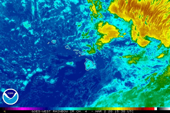
Deeper clouds south to southeast

Showers locally – Looping radar image
Small Craft Advisory…windiest coasts and channels around Maui County and the Big Island
~~~ Hawaii Weather Narrative ~~~
Broad Brush Overview: The trade winds will increase tonight, becoming locally stronger late Thursday and Friday. A band of moisture associated with a dissipating cold front, will produce a few more showers on Kauai tonight. Otherwise, look for a typical trade wind weather pattern, with showers favoring windward slopes of all islands. Winds will decrease during the weekend, likely becoming light and variable over the western half of the island chain into early next week.
Looking Ahead: The increasing trades won’t last long, as a deep north Pacific trough, with its associated cold front will move toward the state during the weekend. This will erode the surface ridge to our north, leading to diminishing trades. As we get into late Sunday or Monday, winds may become light and variable over the western half of the island chain. The models don’t show conditions becoming unstable…with weak trades and afternoon sea breezes over leeward areas.
Here’s a wind profile of the Pacific Ocean – Closer view of the islands / Here’s the vog forecast animation / Here’s the latest weather map
Marine environment details: Trade winds will build through tonight to locally strong levels Thursday and Friday, as the surface ridge strengthens north of the islands. A Small Craft Advisory has been issued for some of the waters around Maui County and south of the Big Island…beginning Thursday morning, continuing through Friday afternoon.
A series of eastward moving low pressure systems, far north of the islands, will continue to generate waves toward the state. This series of swells will provide an increase in surf for north and west facing shores into early next week. The current northwest swell will be reinforced by a couple of smaller swells from a general northwesterly direction through the end of the week. Kauai may block most of the small west-northwest swell at the end of the week. Another larger, reinforcing swell from the north-northwest is due next Monday night and Tuesday.
A series of small southerly swells can be expected through the rest of the week, and except for a slight increase in the surf along east facing shores Friday and Saturday…surf will generally be small there as well.

World-wide tropical cyclone activity
![]()
>>> Atlantic Ocean:
Hurricane 12L (Jose) remains active, here’s a NHC graphical track map, a satellite image…and what the computer models are showing
>>> Caribbean Sea:
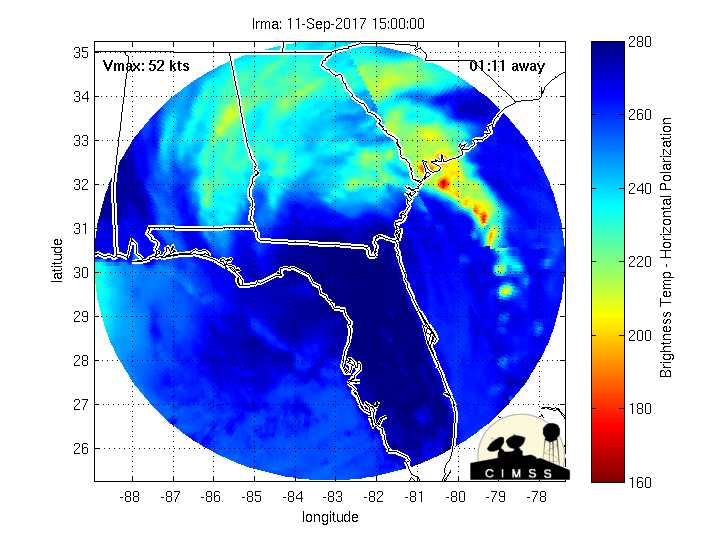
Hurricane 11L (Irma) is a major Category 5 system, here’s a NHC graphical track map, a satellite image…and what the computer models are showing
Here’s a satellite image of this hurricane, with the looping version…along with what the computer models are showing
Long term animation…showing the hurricane moving into the Caribbean Islands.
Here’s a close up view of Hurricane Irma’s eye
>>> Gulf of Mexico: No active tropical cyclones
Hurricane 13L (Katia) remains active, here’s a NHC graphical track map, a satellite image…and what the computer models are showing
Here’s a satellite image of the Caribbean Sea…and the Gulf of Mexico
Here’s the link to the National Hurricane Center (NHC)
>>> Eastern Pacific: No active tropical cyclones
Here’s a wide satellite image that covers the entire area between Mexico, out through the central Pacific…to the International Dateline.
Here’s the link to the National Hurricane Center (NHC)
>>> Central Pacific: No active tropical cyclones
Here’s a link to the Central Pacific Hurricane Center (CPHC)
>>> Northwest Pacific Ocean:
Tropical Depression 19W (Guchl) is dissipating, here’s a JTWC graphical track map, a satellite image – Final Warning
>>> North and South Indian Oceans / Arabian Sea: No active tropical cyclones
Here’s a link to the Joint Typhoon Warning Center (JTWC)
Interesting: No ice to break – Our research cruise is being conducted this year from the Coast Guard Cutter Healy, the newest and most technologically advanced icebreaker in the U.S. fleet. The Healy was built down around the humid bayous of New Orleans, but was designed to conquer Arctic sea ice. The boat is a behemoth at 420 feet long and has made its way to the North Pole on several occasions, taking thousands of scientists into the Arctic to collect data that has transformed our understanding of the region.
Something has changed though in the last few years. The Healy has been having a hard time finding any ice to break. The average sea-ice extent in June 2017 was 350,000 square miles smaller than the long-term historical average. That represents a loss of sea ice almost twice the size of Texas.
The opening of the Arctic is allowing increased commercial ship traffic and in 2016, for the first time, more than 1,000 passengers sailed on the Crystal Serenity from Anchorage to New York through once ice-choked waters. The cruise ship is making the same voyage this year. While the Healy has been responsible for patrolling the Arctic, its mission is expanding as fast as the ice is disappearing. The ship and its more than 80 crew members will be the first responders to any disaster in the Arctic, from vessel emergencies to oil spills.
I asked US Coast Guard Captain Greg Tlapa, Healy commanding officer, about working in the Arctic now that the ice is melting so quickly and he said, “Our main challenge remains the limited number of Coast Guard icebreakers we have, while at the same time our national security requirements for access and presence are growing along with increased scientific interest. With increased ice-free periods comes an increase in human activity, which brings with it a higher demand for missions like search and rescue, law enforcement, maritime border security, and protection of our maritime economy.”
In fact, while we’ve been up here on this mission, the U.S. Exclusive Economic Zone or EEZ has become nearly ice free. This would have been unheard of a decade ago. If this trend continues, the Healy is going to be very busy for the foreseeable future.
Woody Says:
Hi Glen…neat you get to work on the icebeaker and the area…must be very interesting…Da Bess to you,mom&friend Linda….you gize always get a few moments of well-wishes and prayers….Aloha Nui
~~~ Hi Woody, actually I wasn’t on the icebreaker, although it does sound pretty interesting.
Thanks for your well wishes, and best wishes back to you as well.
Aloha, Glenn