


Air Temperatures – The following high temperatures (F) were recorded across the state of Hawaii Tuesday…along with the low temperatures Tuesday:
87 – 72 Lihue, Kauai
87 – 73 Honolulu, Oahu
87 – 68 Molokai
87 – 68 Kahului AP, Maui
88 – 76 Kailua Kona
86 – 70 Hilo AP, Hawaii
Here are the latest 24-hour precipitation totals (inches) for each of the islands as of Tuesday evening:
0.05 Lihue, Kauai
0.14 Palehua, Oahu
0.00 Molokai
0.00 Lanai
0.00 Kahoolawe
0.00 Maui
0.28 Pahala, Big Island
The following numbers represent the strongest wind gusts (mph) as of Tuesday evening:
18 Mana, Kauai
20 Kuaokala, Oahu
18 Molokai
16 Lanai
16 Kahoolawe
23 Maalaea Bay, Maui
24 South Point, Big Island
Hawaii’s Mountains – Here’s a link to the live webcam on the summit of our tallest mountain Mauna Kea (nearly 13,800 feet high) on the Big Island of Hawaii. This webcam is available during the daylight hours here in the islands, and at night whenever there’s a big moon shining down. Also, at night you will be able to see the stars — and the sunrise and sunset too — depending upon weather conditions.
Aloha Paragraphs

A couple of cold fronts north of Hawaii

Thunderstorms far offshore to the southwest
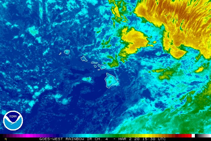
Mostly clear, clouds over parts of the Big Island…weak cold fronts north

Showers locally…mostly offshore – Looping radar image
~~~ Hawaii Weather Narrative ~~~
Broad Brush Overview: Remnants of very early season cold fronts will bring some clouds and showers to Kauai and Oahu Wednesday into the night, with dry conditions expected to continue elsewhere. Trades will begin to return Wednesday, and become locally stronger Thursday. With the trades returning, we can expect trade wind showers to favor the windward and mountain areas, especially during the nights and morning hours. The trade winds will then trend lighter Saturday, and continue through the rest of the weekend…into early next week.
Looking Ahead: The trades will return, as the remnants of the fronts to the northwest approach…and move over Kauai and Oahu. Light trades Wednesday will give way to stronger trades Thursday, as a ridge builds north of the islands. This ridge will be disrupted by another front moving from west to east, north of the islands as we head into the weekend. The moisture from this front is currently expected to remain north of the islands, with trade wind showers continuing through the weekend. Tropical Cyclone activity won’t be a threat through at least the next 5-days.
Here’s a wind profile of the Pacific Ocean – Closer view of the islands / Here’s the vog forecast animation / Here’s the latest weather map
Marine environment details: Winds and seas will remain below Small Craft Advisory criteria through Thursday, although may be required by Friday for the typically windy waters around Maui County and The Big Island…as high pressure builds in to our north.
A series of small southerly swells can be expected through the remainder of the week into the weekend.
An early season north-northwest swell is expected to arrive tonight. A small west swell is possible Thursday and Friday. A small northwest swell is possible Friday through the weekend…surf heights will remain below advisory levels.
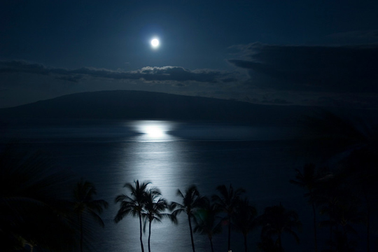
September Full Moon
World-wide tropical cyclone activity
![]()
>>> Atlantic Ocean:
Tropical Storm 12L (Jose) remains active, here’s a NHC graphical track map, a satellite image…and what the computer models are showing
>>> Caribbean Sea:
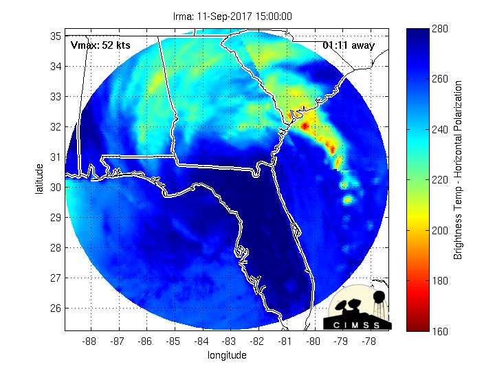
Hurricane 11L (Irma) is a major Category 5 system, here’s a NHC graphical track map, a satellite image…and what the computer models are showing
Here’s a satellite image of this hurricane, with the looping version…along with what the computer models are showing
Long term animation…showing the hurricane moving into the Caribbean Islands.
Here’s a close up view of Hurricane Irma’s eye
>>> Gulf of Mexico: No active tropical cyclones
Tropical Storm 13L (Katia) remains active, here’s a NHC graphical track map, a satellite image…and what the computer models are showing
Here’s a satellite image of the Caribbean Sea…and the Gulf of Mexico
Here’s the link to the National Hurricane Center (NHC)
>>> Eastern Pacific: No active tropical cyclones
Here’s a wide satellite image that covers the entire area between Mexico, out through the central Pacific…to the International Dateline.
Here’s the link to the National Hurricane Center (NHC)
>>> Central Pacific: No active tropical cyclones
Here’s a link to the Central Pacific Hurricane Center (CPHC)
>>> Northwest Pacific Ocean:
Tropical Depression 19W (Guchl) is active, here’s a JTWC graphical track map, a satellite image…and what the computer models are showing
>>> North and South Indian Oceans / Arabian Sea: No active tropical cyclones
Here’s a link to the Joint Typhoon Warning Center (JTWC)
Interesting: A FASCINATING SHORT SEA STORY – The passenger steamer SS Warrimoo was quietly knifing its way through the waters of the mid-Pacific on its way from Vancouver to Australia. The navigator had just finished working out a star fix and brought the master, Captain John Phillips, the result. The Warrimoo’s position was LAT 0º 31′ N and LON 179 30′ W. The date was 31 December 1899.
The SS Warrimoo lay on the Equator at exactly the point where it crossed the International Date Line! The consequences of this bizarre position were many:
The forward part (bow) of the ship was in the Southern Hemisphere & in the middle of summer.
The rear (stern) was in the Northern Hemisphere & in the middle of winter.
The date in the aft part of the ship was 31 December 1899. In the bow it was 1 January 1900.
This ship was therefore not only in
Two different days,
Two different months,
Two different years,
Two different seasons
Topher Says:
My Boy is in St. John. Please say a prayer! Thanks Glen for all the info.
~~~ Hi Topher, best of luck to your Son!
Glad my information is coming in handy.
Aloha, Glenn
Helen Says:
Our thoughts and prayers are going out to everyone in the path of Irma.
~~~ Helen, I’m with you on that!
Aloha, Glenn
Diane Says:
Hi Glenn,
Great story!!!!
I plan to share with others.
Thank you for sharing it and the other great info on your website????
Diane from NorCal(man has it been hot AND humid!
~~~ Hi Diane, glad you liked the story too!
You are very welcome, I’m pleased to offer weather information to you.
Hot, hot, hot…and muggy too!
Aloha, Glenn
Gerald Durkan Says:
Hi Glenn,
Fun story. We enjoyed straddling the international date line while in Fiji on the island of Taveuni. Also while there we were on a dive boat and the captain would wander back and forth across the IDL saying “today, tomorrow,today, …
I enjoy your website and check it often.
~~~ Hi Gerald, good hearing from you, glad you find value in referring to my website!
Interesting tidbit you share with us too, that sounds like a kick…and especially with your fun-loving boat captain down near Fiji!
Aloha, Glenn
Jay Says:
The story of the s.s. Warrimoo was very cool…thanks
~~~ Hi Jay, I agree…I found it very unusual and interesting too!
Thanks for letting me know.
Aloha, Glenn