


Air Temperatures – The following high temperatures (F) were recorded across the state of Hawaii Wednesday…along with the low temperatures Wednesday:
84 – 73 Lihue, Kauai
88 – 73 Honolulu, Oahu
83 – 67 Molokai
84 – 67 Kahului AP, Maui
85 – 73 Kona Int’l AP
83 – 70 Hilo AP, Hawaii
Here are the latest 24-hour precipitation totals (inches) for each of the islands as of Wednesday evening:
0.28 N Wailua Ditch, Kauai
0.15 Ahuimanu Loop, Oahu
0.00 Molokai
0.00 Lanai
0.00 Kahoolawe
0.06 West Wailuaiki, Maui
0.30 Saddle Quarry, Big Island
The following numbers represent the strongest wind gusts (mph) as of Wednesday evening:
17 Poipu, Kauai
27 Oahu Forest NWR, Oahu
28 Molokai
32 Lanai
27 Kahoolawe
27 Maalaea Bay, Maui
30 Kealakomo, Big Island
Hawaii’s Mountains – Here’s a link to the live webcam on the summit of our tallest mountain Mauna Kea (nearly 13,800 feet high) on the Big Island of Hawaii. This webcam is available during the daylight hours here in the islands, and at night whenever there’s a big moon shining down. Also, at night you will be able to see the stars — and the sunrise and sunset too — depending upon weather conditions.
Aloha Paragraphs

The Pacific storm track is well north of the islands

A ragged late season cold front is north of the islands

Clear to partly cloudy skies for the most part…some locally cloudy areas

Showers…although just a few – Looping radar image
Small Craft Advisory…windiest waters around Maui County and the Big Island
~~~ Hawaii Weather Narrative ~~~
Broad Brush Overview: A strong surface high pressure system north of the islands, will move east and strengthen through the week. A ridge of high pressure aloft, will remain over the area through Saturday. The surface high will move south and weaken Sunday…as a trough of low pressure aloft digs northwest of the islands.
Details: Breezy trade winds would normally be expected, with a strong high pressure system north of the area, although a weak cold front north of the islands, is weakening the pressure gradient south of the high. The front is expected to dissipate over the next 24 hours, and as it does…the trade winds will strengthen. As the trades gain this strength, showers will be focused over windward areas. A ridge aloft will build over the area and keep the atmosphere stable, keeping the leeward areas mostly dry.
Looking Ahead: The surface high pressure system will weaken early next week, and the trade winds will subside in turn. A trough of low pressure aloft will deepen northwest of the islands, so that the atmosphere will become less stable…and showers may become more active. During the second half of next week, the trough aloft will weaken. A new surface high will move into position north of the islands, and trade winds will strengthen again.
Here’s a wind profile of the Pacific Ocean – Closer view of the islands / Here’s the vog forecast animation / Here’s the latest weather map
Marine environment details: A surface high passing far north of the main Hawaiian Islands, will drive locally strong trades across local waters. A Small Craft Advisory (SCA) is now in effect through at least Friday…over the typically windier areas around Maui County and the Big Island.
Surf is expected to stay below advisory levels through the weekend. A small to moderate south swell will continue to lower over the next day or so. No significant swells from the south are expected through the weekend.
North and west facing shores will be impacted by a series of northwest swells through early next week. A moderate north-northwest swell will spread across local waters Thursday, followed by a larger northwest swell late Saturday night and Sunday. Surf from this second swell may approach advisory levels for the north and west facing shores of Kauai Sunday night and Monday…before slowly lowering through Tuesday.

Trade winds will increase in strength Thursday
San Francisco Bay Weather Brief: After several days of well above normal temperatures, the immediate coastal areas saw a distinct cooling this afternoon, with an area wide cool down beginning Thursday…as the marine influence and onshore flow increases further. Additional cooling is expected Friday, which will persist into the weekend. In addition, a slight chance of showers are expected Saturday into Sunday, yet widespread rainfall is not likely at this time. Locally windy conditions are also expected through the weekend.
.
The weather over the SF Bay area is turning cooler…as the marine influence increases
World-wide tropical cyclone activity\
![]()
>>> Atlantic Ocean: The 2017 hurricane season begins June 1st
>>> Caribbean: The 2017 hurricane season begins June 1st
>>> Gulf of Mexico: The 2017 hurricane season begins June 1st
Here’s a satellite image of the Caribbean Sea…and the Gulf of Mexico
Here’s the link to the National Hurricane Center (NHC)
>>> Eastern Pacific: The 2017 hurricane season begins May 15th
Here’s the NOAA 2016 Hurricane Season Summary for the Eastern Pacific Basin
Here’s a wide satellite image that covers the entire area between Mexico, out through the central Pacific…to the International Dateline.
Here’s the link to the National Hurricane Center (NHC)
>>> Central Pacific: The 2017 hurricane season begins June 1st
Here’s the NOAA 2016 Hurricane Season Summary for the Central Pacific Basin
Here’s a link to the Central Pacific Hurricane Center (CPHC)
>>> Northwest Pacific Ocean: No active tropical cyclones
Tropical Cyclone 18P (Donna) remains active in the southwest Pacific, here’s the graphical track map, a satellite image…and what the computer models are showing
>>> North and South Indian Oceans / Arabian Sea: No active tropical cyclones
Here’s a link to the Joint Typhoon Warning Center (JTWC)
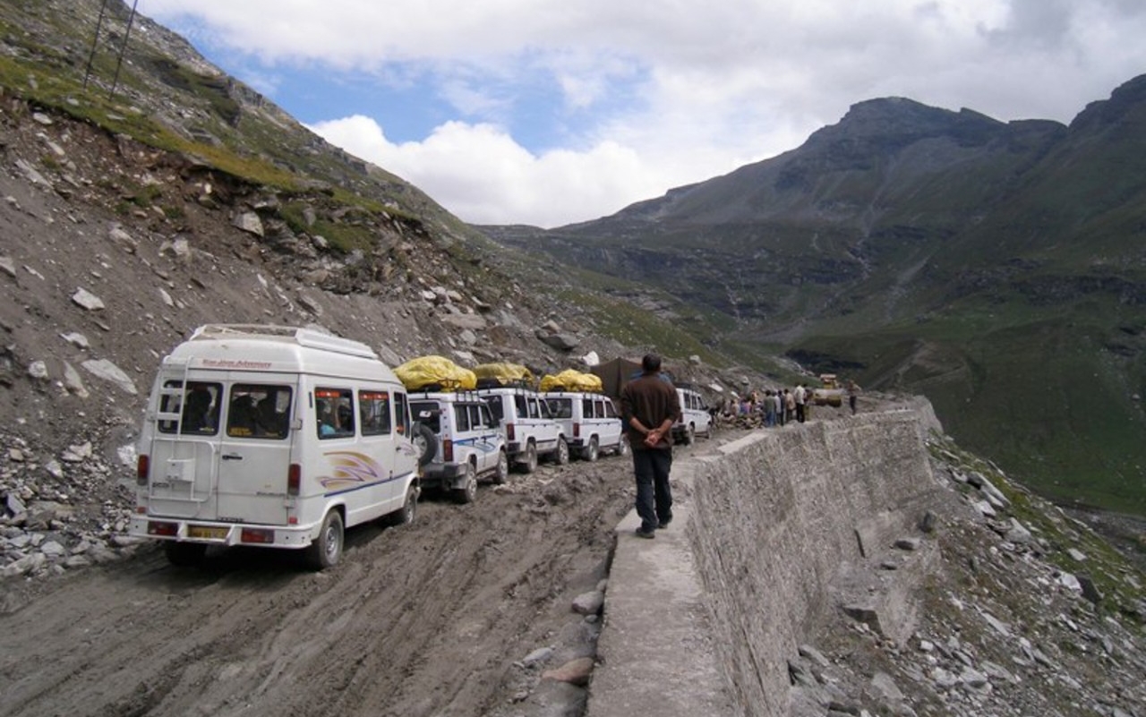
Interesting: Not even the Himalayas are immune to traffic smog – Smog from cars and trucks is an expected health hazard in big cities, but researchers from the University of Cincinnati found pollution from truck exhaust on one of the most remote mountain roads in the world.
Brooke Crowley, an assistant professor of geology and anthropology, and UC graduate student Rajarshi Dasgupta examined soil pollution along India’s Manali-Leh Highway in the Himalaya Mountains.
This tortuous 300-mile route, much of it gravel or dirt, winds its way over one of the highest navigable mountain passes in the world at 17,480 feet. That’s 4,000 feet higher in elevation than the top of Wyoming’s Grand Teton.
The road’s very remoteness has made it an international tourist attraction, drawing cyclists and adventurers keen on treading where so few have.
Even here in one of the most distant corners of the planet, a place of desolate valleys and austere beauty, the researchers in UC’s McMicken College of Arts and Sciences found evidence of pollution from diesel exhaust.
“We measured incredibly high amounts of sulfur close to the highway. Some of those values are the highest ever reported in the literature and were likely connected to truck traffic,” Crowley said.
The results were published in the journal Archives of Environmental Contamination and Toxicology. The research was funded through grants by the UC Research Council, Sigma Xi and the Oak Ridge Associated Universities.
For the study, Dasgupta took soil samples at four places along the highway and at six prescribed distances, starting with samples literally on the dirt road and extending out 150 meters. Soil samples were collected at 3, 9 and 15 centimeters in depth.
Dasgupta said villagers in this area burn wood and cow dung for cooking and heating their homes. The resulting smoke often contains polycyclic aromatic hydrocarbons, a known carcinogen.
They tested the soil for these hydrocarbons along with sulfur, total organic compound and 10 types of heavy metal. This wide net was necessary to capture the myriad potential pollutants caused by truck traffic, Dasgupta said.
The study found low levels of heavy metals and no relationship between their concentrations and distance from the highway. But they found high concentrations of sulfur, a major pollutant in the exhaust of diesel-powered engines.
“This area provided us with a rare opportunity to examine the effects of multiple contaminants in a remote, diesel-dominated, mountainous environment,” Dasgupta said.
Comparative studies have found that India’s diesel contains an especially high sulfur content, the UC researchers said. Sulfur dioxide in the atmosphere contributes to acid rain.
“At first glance, it’s easy to consider the region to be a pretty pristine place. But there are environmental impacts from humans,” Crowley said.
Last year India ratified the Paris Agreement on climate change. The world’s second-largest nation by population produces nearly 5 percent of the world’s greenhouse gases. The agreement calls for participating countries to develop a plan to address temperature rise.
India has a goal of producing 40 percent of its electricity with renewable energy by 2030.
Diesel fuel is popular in India because it historically cost drivers less there than regular unleaded. Most of the buses and heavy trucks that traverse the Manali-Leh Highway burn diesel fuel. Completed in the 1970s, the road between Manali and Leh sees about 50,000 vehicles per year, mostly during the summer when the mountain passes are free of snow, according to government traffic counts. Himalaya means “abode of snow” in Sanskrit.
UC researchers found the highest sulfur contents at the base of the narrow ridges that are most prone to rock slides. Trucks sometimes must wait to use a single lane while construction crews make repairs.
“The road is terrible, and it’s almost always under construction. There can be lines of traffic idling waiting to go over the passes,” she said. “Our results suggest that a fair amount of emissions accumulate in the soil.”
UC professor Lewis Owen, the geology department head, said Crowley’s findings are in keeping with other studies on pollution impacts in the region.
“It’s not surprising at all if you’ve ever been to the Himalayas and seen all the diesel trucks that use the highways,” he said.
Air pollution from Asian cities also ends up contaminating the remote region’s mountains and streams, he said.
“There is no pristine environment left. You see black snow deposited on glaciers and snowfields in Tibet,” Owen said. “This study is adding to our data set about how we’re degrading the planet. Humans are the biggest geologic agents now. Some researchers are calling this geologic age ‘the Anthropocene’ after the human influence.”
This study and others like it show the cumulative effect of fossil fuels on the environment, he said.
“The biggest challenge is for the research to be disseminated to people who can do something about it,” he said.
Dasgupta said countries can monitor pollution and its resulting health effects and invest in more renewable energy and other eco-friendly alternatives to reduce their carbon footprint.
“There is no doubt that increasing economic development will put more stress on environments all over the world, remote or not,” Dasgupta said.
UC’s Crowley has published studies on topics as diverse as plant defenses against species of now-extinct lemurs and the long-distance treks of extinct mammoths.
The study marked Crowley’s second visit to the Himalaya region. But Crowley’s scientific interests have taken her around the world. She has made four trips to Madagascar to study lemurs and reconstruct the causes and consequences of extinctions on the island. She and her students have examined the effects of sea spray on vegetation in Trinidad and looked at ways the first humans in the Canary Islands changed its ecology.
“I’m a paleoecologist. I’m interested in human-animal interactions. I haven’t conducted pollution research previously, and this study with Rajarshi has stretched me in a new direction,” she said.
Dasgupta said the study proved to be a learning experience for him as well.
“This study was the first of its kind for me, too,” Dasgupta said. “I am a geomorphologist. I study the evolution of the landforms around us. However, as a geographer, I have always been interested in the interactions of humans with the natural environment – the central theme of all geographic research. This study fits that theme perfectly.”
In the Himalayas, the researchers found native wildlife such as ibex, herds of wild asses called kiang and condors, one of the largest birds on the planet. Adding to the bucolic scene, many of the villagers who live in the foothills tend goats.
“It’s a beautiful landscape. The scale is hard to comprehend when you’re driving on a plain at 15,000 feet above sea level. That’s really high. It takes a while to acclimatize to the elevation,” Crowley said.
The night skies were full of stars in that sparsely inhabited part of India, with little moisture in the atmosphere to obscure the view. The arid mountains have little vegetation and lots of exposed strata of rock.
“It’s a geologist’s dream. UC professors in geology have been conducting research and teaching classes in this region for many years,” she said. “I am so grateful I was able to join them in the field.”
But being in the field can be challenging. The researchers had to hire an experienced driver to take them over the mountains. They used a filtration system to provide clean drinking water. In some of the low-lying areas, they had to help push their truck out of the mud.
“We’ve gotten a flat tire both times we’ve gone to India. You need nerves of steel to deal with the blind curves,” she said.
Crowley said places on the extreme edges of habitability such as the Himalayas could be the first to feel the effects of dramatic climate change. These mountain ranges provide water and nutrients for rivers in India.
“These are places that might have perennial glaciers that are important sources of water. If the glaciers disappear, that has major implications for people who rely on that water,” she said.
The samples collected for this study provide baseline data if researchers decide to revisit the topic of roadside pollution in 10 or 20 years, she said.
And given her track record of travel for UC, Crowley might be the one leading that expedition, too.
“One of the joys of being a professor is you have some freedom in the kinds of research questions you can explore,” she said. “I have appreciated that opportunity here at UC.”
Helen Says:
We have had some lovely trade winds today !!!
hope all is well with you and yours!
~~~ Hi Helen, nice to hear of the balmy trade winds today…we all love these breezes off the ocean!
We are all doing well, thanks Helen! I trust you are well and fine too!
Aloha, Glenn