


Air Temperatures – The following high temperatures (F) were recorded across the state of Hawaii Friday…along with the low temperatures Friday:
84 – 72 Lihue, Kauai
87 – 73 Honolulu, Oahu
83 – 68 Molokai
86 – 66 Kahului AP, Maui
83 – 71 Kona Int’l AP
82 – 68 Hilo AP, Hawaii
Here are the latest 24-hour precipitation totals (inches) for each of the islands as of Friday evening:
7.46 Mount Waialeale, Kauai
0.46 Poamoho RG 1, Oahu
0.01 Molokai
0.01 Lanai
0.00 Kahoolawe
2.12 Puu Kukui, Maui
0.92 Saddle Quarry, Big Island
The following numbers represent the strongest wind gusts (mph) as of Friday evening:
25 Port Allen, Kauai
32 Oahu Forest NWR, Oahu
31 Molokai
32 Lanai
38 Kahoolawe
32 Kahului AP, Maui
32 Waikoloa, Big Island
Hawaii’s Mountains – Here’s a link to the live webcam on the summit of our tallest mountain Mauna Kea (nearly 13,800 feet high) on the Big Island of Hawaii. This webcam is available during the daylight hours here in the islands, and at night whenever there’s a big moon shining down. Also, at night you will be able to see the stars — and the sunrise and sunset too — depending upon weather conditions.
Aloha Paragraphs

An upper level low pressure system northwest

Thunderstorms west and northwest of Kauai

Clear to partly cloudy…especially rainy clouds near Kauai

Showers mostly offshore…some locally heavy
Looping radar image
Small Craft Advisory…windiest coasts and channels around Maui County, including the Kaiwi Channel, and the Big Island
~~~ Hawaii Weather Narrative ~~~
Broad Brush Overview: Moderate to locally strong and gusty trade winds will persist through at least early next week, as strong high pressure system remains far northeast of the state. Clouds and showers will favor windward areas, although will occasionally spread leeward. Wetter conditions are expected for the second half of the weekend into early next week…as an upper trough enhances bands of moisture moving along in the trade flow.
Details: The trade wind flow will bring periods of enhanced showers during the weekend. The surface high will hold firm, as the area of low pressure to the west of Kauai fills. This will cause the trade winds to impact more of the island chain to stronger trades. The upper level trough will linger near and west of Kauai, maintaining somewhat unstable conditions over the western end of the state. Bands of low level moisture will move through, one on Saturday and another Sunday. These features will focus rainfall along windward slopes, with some showers spilling leeward on the trades…with drier conditions between the bands.
Looking Further Ahead: Shower coverage and intensity may pick up late Sunday through Tuesday over portions of the state. The models are showing the upper trough digging over and northeast of the islands, though they differ on the strength of this weather feature. For now, a rather wet trade wind rainfall pattern remains likely, with higher rainfall chances near the Big Island and Maui.
Here’s a wind profile of the Pacific Ocean – Closer view of the islands / Here’s the vog forecast animation / Here’s the latest weather map
Marine environment details: The latest surface analysis showed weak low pressure west of the area, and a strong high pressure center north-northeast of the state. The trades will become stronger across local waters into next week. A small craft advisory for the channels east of Molokai, Maalaea Bay, the windward Maui County waters, and the waters south of the Big Island has been extended through Sunday.
Surf along the north facing shores will remain small into next week, with no significant swells expected. Mainly trade wind swell wrap at select spots will be the only real source supporting surf through the weekend. For the extended, a small northwest swell will arrive through the second half of next week.
Surf along east facing shores will steadily rise through the weekend, as stronger trade winds become established. These strong onshore winds will translate to rough surf along east facing shores each day. Surf will near the advisory level over the weekend into next week for the windward sides.
A small reinforcing south swell is expected to today from recent southern Pacific activity. This will support moderate south shore surf into the weekend. For the long range, a more active pattern is forecast to setup across the southern Pacific, east and southeast of New Zealand …which will likely correspond to a rise in surf along south facing shores through the second half of the month, beginning a week from today.
Well established trade wind weather pattern
San Francisco Bay Weather Brief: Cooler than normal temperatures, along with breezy onshore winds can be expected through early next week. While most areas will remain dry through the weekend, there is a slight chance of rain late Monday into Tuesday…as a low pressure system approaches from the north. A warming trend is then expected as a result of building high pressure by mid-week.
.
Mostly clear…cloud patches approaching to the northwest
World-wide tropical cyclone activity
![]()
>>> Atlantic Ocean: The 2017 hurricane season begins June 1st
>>> Caribbean: The 2017 hurricane season begins June 1st
>>> Gulf of Mexico: The 2017 hurricane season begins June 1st
Here’s a satellite image of the Caribbean Sea…and the Gulf of Mexico
Here’s the link to the National Hurricane Center (NHC)
>>> Eastern Pacific: The 2017 hurricane season begins May 15th
Here’s the NOAA 2016 Hurricane Season Summary for the Eastern Pacific Basin
Here’s a wide satellite image that covers the entire area between Mexico, out through the central Pacific…to the International Dateline.
Here’s the link to the National Hurricane Center (NHC)
>>> Central Pacific: The 2017 hurricane season begins June 1st
Here’s the NOAA 2016 Hurricane Season Summary for the Central Pacific Basin
Here’s a link to the Central Pacific Hurricane Center (CPHC)
>>> Northwest Pacific Ocean: No active tropical cyclones
Tropical Cyclone 19P (Ella) remains active in the southwest Pacific, here’s the graphical track map, a satellite image…and what the computer models are showing
>>> North and South Indian Oceans / Arabian Sea: No active tropical cyclones
Here’s a link to the Joint Typhoon Warning Center (JTWC)
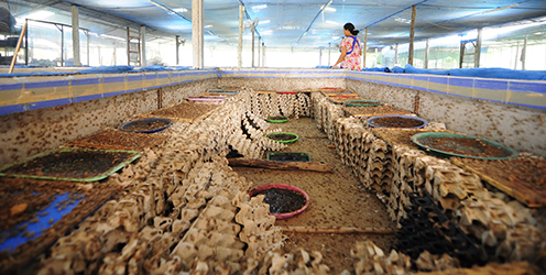
Interesting: Six-legged livestock…sustainable food production – Farming crickets for human consumption is less of a burden on the environment than other livestock production systems according to a new study by the University of Copenhagen’s Department of Nutrition, Exercise and Sports and Department of Plant and Environmental Sciences. Results suggest that insect farming systems can be improved to become even more environmentally sustainable in the future.
Identifying areas of particular high impact is an important step to improving the environmental sustainability of production systems. Insects have been heralded as the foods of the future – and now the first study to measure the environmental impacts and identify hot spots associated with commercial insect production has been published.
Cricket farming can be a sustainable way to produce animal source foods
The study demonstrated that cricket farming can be a sustainable means of producing animal source foods. The study compared cricket production in Thailand to broiler chicken production. Fifteen different environmental impacts were investigated including global warming potential, resource depletion and eutrophication. In most cases, cricket production had a lower impact than broiler chicken production. The major reason for the lower impacts is the fact that the feed conversion into animal protein is more efficient, as the production of the feed is a major hot spot in both systems.
“This research is very timely, as there are many different stakeholders interested in farmed insects. Many people have seen insects as a means of lowering the environmental burden of animal production. Insects, in many cases, can be comparable to meat and fish in terms of nutritional value. The fact that we have shown here that they can be produced more environmentally sustainable than meat means that they represent a massive potential for lowering the impact of the food production” explains lead author, PhD student Afton Halloran of the University of Copenhagen’s Department of Nutrition, Exercise and Sports.
Possibility to become even more environmentally sustainable
The study also demonstrated the need for further research to look into alternative ways of feeding the crickets:
“While crickets consume plant matter in the wild, farmers started to use commercial chicken feeds because they saw that the crickets grew faster. Unfortunately, the production of feed ingredients like maize and soy can have detrimental effects on the environment. Luckily our colleagues at the Department of Entomology, Khon Kaen University are looking into other feed sources farmed crickets, such as different kinds of plants and waste products” concludes PhD student Afton Halloran.
In Thailand, cricket farming has been occurring for nearly 20 years with 20,000 farms scattered throughout the northeastern and northern parts of the country. Around the world, there are over 2,000 insect species that are regularly eaten. Most of these species are harvested from the wild, but around nine insect species are currently farmed for food and feed.
woody adamz Says:
Alohas Glenn\Mom/Linda…..????….Reading article you posted and thinking,these 747 sized cockroaches here in 808land..Maybe time for a”McC”with side of “pede” and a Red Ant Smoothie ……Yummy…..?…..;YUK……!???? ……..
~~~ Hi Woody, good one, not sure everyone will know what you mean, although if one lives in Hawaii, it will be quite clear!
Aloha, Glenn