


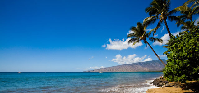
Air Temperatures – The following high temperatures (F) were recorded across the state of Hawaii Monday…along with the low temperatures Monday:
82 – 64 Lihue, Kauai
83 – 65 Honolulu, Oahu
85 – 64 Kahului AP, Maui
73 – 68 Kona Int’l AP
85 – 69 Hilo AP, Hawaii
Here are the latest 24-hour precipitation totals (inches) for each of the islands as of Monday evening:
0.04 Mount Waialeale, Kauai
0.04 Moanalua, Oahu
0.12 Molokai
0.07 Lanai
0.18 Kahoolawe
0.52 West Wailuaiki, Maui
1.56 Kealakomo, Big Island
The following numbers represent the strongest wind gusts (mph) as of Monday evening:
18 Waimea Heights, Kauai
18 Kii, Oahu
22 Molokai
21 Lanai
21 Kahoolawe
20 Maalaea Bay, Maui
25 South Point, Big Island
Hawaii’s Mountains – Here’s a link to the live webcam on the summit of our tallest mountain Mauna Kea (nearly 13,800 feet high) on the Big Island of Hawaii. This webcam is available during the daylight hours here in the islands, and at night whenever there’s a big moon shining down. Also, at night you will be able to see the stars — and the sunrise and sunset too — depending upon weather conditions.
Aloha Paragraphs

An upper level low pressure system is moving away

Rainy clouds have moved away…although a few wet areas remain

Heavy weather…although mostly to our south

Showers…some locally
Looping radar image
~~~ Hawaii Weather Narrative ~~~
Broad Brush Overview: A typical trade wind weather pattern is expected to return for the rest of the week, although with a few leftover downpours here and there into the evening hours locally. Passing clouds and showers will be possible over windward and mountain areas, with drier conditions leeward.
Details: A weakening low pressure system will continue to drift away from the islands tonight and Tuesday. Stable atmospheric conditions remained in place this afternoon over the smaller islands, with the Big Island also showing more stable air. Moisture has returned, however stronger than predicted subsidence and stability resulted…in dramatically sunnier and warmer weather Monday across most of the state.
High pressure will re-building to the north will bring a return of light to moderate trade winds across the state beginning Tuesday. The trades will be gentle enough to allow for afternoon sea breezes and clouds in some leeward areas. The overlying air mass will be stable, and most showers will fall along the windward sides. By the weekend, some increase in moisture is possible…as the remnants of an old cold front may move in.
Looking Ahead: The longer range guidance hints that we may have yet another late season cold front in store early next week…although there is low confidence of this occurring out that far into the future.
Here’s a wind profile of the Pacific Ocean – Closer view of the islands / Here’s the vog forecast animation / Here’s the latest weather map
Marine environment details: The low level wind flow will be becoming mainly southeast across the island chain, continuing through Tuesday. The strength of these winds are expected to reach small craft advisory (SCA) level this morning, across the windward and leeward coastal waters of Maui County and the Big Island.
As the current south swell lowers, another one should be arriving soon. Expect surf to max-out just below the advisory level criteria for the south facing shores later today. The swell is expect to start lowering Tuesday afternoon. No other south swell is expected for the rest of the week.
A moderate northwest swell has peaked, and will be lowering gradually through the day. A series of northwest swells are expected, the first is due on Thursday, with a small to medium size swell. A larger moderate swell arrives Saturday night and Sunday. The anticipated return of the trade winds later this week means the surf will rise slightly along the east facing shores.
Higher than normal high tides are expected to continue for the next couple of days. These high tides will be coupled with a re-enforcing swell from the south later tonight, maintaining elevated water levels through Tuesday. The greatest chance for beach problems will be during the evening hours…when the high tides will be at their highest. A return to normal tides is expected Wednesday.
Improving weather
San Francisco Bay Weather Brief: Clear and warm weather will continue through Tuesday. Cooling arrives along the Big Sur coast Wednesday , while hot and dry weather will persist inland. Modest cooling trend arrives all areas by Thursday…as cooler coastal stratus returns. Cooling trend continues Friday into Saturday when a slight chance of showers is forecast, as an upper low approaches the region.
.
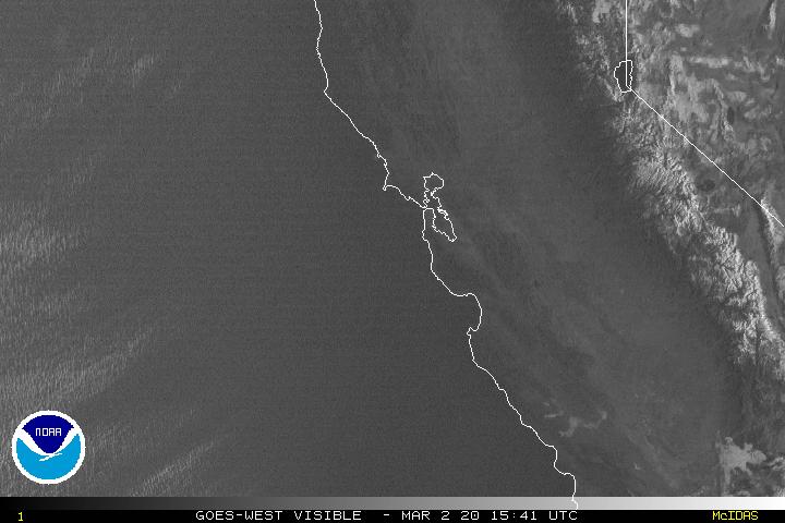
Very warm to hot weather over northern California
World-wide tropical cyclone activity
![]()
>>> Atlantic Ocean: The 2017 hurricane season begins June 1st
>>> Caribbean: The 2017 hurricane season begins June 1st
>>> Gulf of Mexico: The 2017 hurricane season begins June 1st
Here’s a satellite image of the Caribbean Sea…and the Gulf of Mexico
Here’s the link to the National Hurricane Center (NHC)
>>> Eastern Pacific: The 2017 hurricane season begins May 15th
Here’s the NOAA 2016 Hurricane Season Summary for the Eastern Pacific Basin
Here’s a wide satellite image that covers the entire area between Mexico, out through the central Pacific…to the International Dateline.
Here’s the link to the National Hurricane Center (NHC)
>>> Central Pacific: The 2017 hurricane season begins June 1st
Here’s the NOAA 2016 Hurricane Season Summary for the Central Pacific Basin
Here’s a link to the Central Pacific Hurricane Center (CPHC)
>>> Northwest Pacific Ocean: No active tropical cyclones
>>> North and South Indian Oceans / Arabian Sea: No active tropical cyclones
Here’s a link to the Joint Typhoon Warning Center (JTWC)
Interesting: New coral bleaching database to help predict fate of global reefs – Until now, knowledge of the geographic extent of mass coral bleaching has been incomplete. “We know that mass coral bleaching is happening all over the world, but the majority of events are in places in the developing world where the capacity for monitoring them is limited,” said Simon Donner, associate professor in the department of geography and the Institute for the Oceans and Fisheries at UBC. “But no report doesn’t mean bleaching didn’t happen. It could be that the monitoring resources are not available or the reefs are too remote to visit.”
To build the database, the researchers scoured academic journals, government documents and other sources for reports of coral bleaching missing from an existing voluntary database commonly used by scientists. Then, they personally contacted local experts in places where they suspected coral bleaching had occurred.
So far, their database contains 79 per cent more reports than the voluntary database. The researchers also found two-thirds of the new reports show moderate or severe bleaching. Using the data, Donner and his team also created global maps showing areas where coral bleaching likely occurred between 1985 and 2010, despite the lack of previous reports.
The database will help scientists more accurately assess changes in the frequency of mass coral bleaching. It will also help predict future bleaching from ocean temperatures and allow scientists to test whether coral reefs are adjusting to rising ocean temperatures.
“If oceans continue warming at the current rate for the rest of the century, it’s likely that we won’t have many corals left,” said Donner. “About a quarter of the ocean’s biodiversity exists on coral reefs. People depend on them for food, income and protection from rising seas.”
A loss of the world’s coral reefs from climate change would be disastrous for people in the tropics and Donner encourages everyone to contribute to the open-source database.
“You don’t even have to be a scientist,” he said. “To anyone who is a diver, your citizen-scientist engagement can be valuable for us trying to understand what’s happening to coral reefs around the planet.”
jeff mcconnel Says:
Aloha Glenn,
In today’s page you mentioned high tides for the next couple of days, have you seen this article? It is very interesting, fairly locally based and temporary tides in Hawaii. http://raisingislands.blogspot.com/2017/04/hawaii-tides-running-8inches-higher.html
Enjoy the warm and dry weather in Northern Cal, relax and unwind. We are enjoying the addition of all the great rains here on the Big Island.
~~~ Hi Jeff, no, I hadn’t seen that article on tides in Hawaii…thanks for pointing it out to us.
Yes, I’m here in northern California, although I’m busy, keeping my work going on this website, plus working my Pacific Disaster Center work as well. In addition, my friend Linda is keeping me pretty busy as well. Certainly not in vacation mode by any means.
Enjoy the rains as best you can there on the Big Island, I’ll be living through a hot spell here in Marin County!
Thanks for your note, and the link too.
Aloha, Glenn
Aloha jeff
woody adamz Says:
Someone got a snorkel….? We’ve had over a foot of rain since yesterday here in mid-Puna, Ainaloa (Big Island)……just DUMPING….lightens a little and then….Whoooooosh….Heavy Stuff. This is when I envy the ducks…..Salutations Mom and Linda ……Oh, I guess to Glen also…Lol……
~~~ Hi Woody, wet, wet, wet, fortunately, relief is up ahead. Although we likely have another day or two of threatening weather, especially over the eastern islands…although elsewhere at times too.
Thanks for your well wishes!
Aloha, Glenn