


Air Temperatures – The following maximum temperatures (F) were recorded across the state of Hawaii Wednesday…along with the minimum temperatures Wednesday:
80 – 65 Lihue, Kauai
80 – 66 Honolulu, Oahu
79 – 54 Molokai AP
82 – 58 Kahului, Maui
83 – 65 Kailua Kona
83 – 64 Hilo, Hawaii
Here are the latest 24-hour precipitation totals (inches) for each of the islands, as of Wednesday evening:
0.00 Kauai
0.04 Palehua, Oahu
0.00 Molokai
0.00 Lanai
0.00 Kahoolawe
0.00 Maui
0.01 Pali 2, Big Island
The following numbers represent the strongest wind gusts (mph)…as of Wednesday evening:
15 Puu Opae, Kauai – SE
17 Wheeler AAF, Oahu – SSW
12 Molokai – SE
12 Lanai – SW
06 Kahoolawe – SW
12 Kaupo Gap, Maui – NE
17 South Point, Big Island – ENE
Hawaii’s Mountains – Here’s a link to the live web cam on the summit of near 13,800 foot Mauna Kea on the Big Island of Hawaii. This web cam is available during the daylight hours here in the islands…and when there’s a big moon shining down during the night at times. Plus, during the nights you will be able to see stars, and the sunrise and sunset too… depending upon weather conditions.
Aloha Paragraphs

A cold front to the northwest

Increasing clouds offshore to the southwest

A few light showers…mostly leeward sides
~~~ Hawaii Weather Narrative ~~~
High Surf Advisory…most north and west shores
Small Craft Advisory…Kauai through Maui County
Generally light southwest to southeasterly winds. Here’s the latest weather map, showing the Hawaiian Islands, and the rest of the North Pacific Ocean, along with a real-time wind profiler of the central Pacific. We find a couple of weak high pressure systems to the northeast. At the same time, we have low pressure systems to the northwest through north and northeast, with the tail-end of an associated cold front draping southwestward…to the northwest of Kauai. We’ll find light winds this week, with daytime sea breezes…although becoming more breezy from the southwest near Kauai and Oahu, as a cold front stretches down in our direction later Thursday-Friday into Saturday. Meanwhile, those areas that are exposed to light southeasterly breezes will continue to see volcanic haze (vog). It looks like the trade winds will hold off returning until late this coming weekend into next Monday or so…briefly. It appears that more light winds will return thereafter, as another cold front approaches the state by Tuesday onwards for several days.
Rainfall will remain limited…with just a few showers along our south and southwest facing areas. Here’s the looping radar image showing just a few showers across our area. We’ll see our winds remaining light for the most part, carrying a few light showers our way. At the same time, these light winds will prompt clear to partly cloudy mornings, giving way to afternoon upcountry clouds…although showers will be spotty. A high pressure ridge remains stalled over the islands, continuing the light winds, and keeping a mostly dry weather pattern in place. The cold front to the northwest will likely bring a few showers to Kauai later this week. It appears that the front will stall or dissipate before pushing down through the rest of the state. Meanwhile, an area of showers, that will be picked up by the returning trades Sunday into next Monday, should bring some windward biased showers to both the Big Island and Maui. I’ll be back with more updates on all of the above, I hope you have a great Wednesday night wherever you’re spending it! Aloha for now…Glenn.
Here in Kula, Maui: The volcanic haze, better known as vog, has been thick and long lasting here on Maui. The view of the West Maui Mountains, from here on the slopes of the Haleakala Crater, is completely gone at the time of this writing. There doesn’t look there’s going to be much relief from this stagnant atmosphere, if any…through the rest of this week. Looking into early next week, it appears that a ridge of high pressure will remain over the state, suggesting that this vog will be part and parcel of our weather conditions well into the future. At the same time, we find light winds, characterized by onshore sea breezes during the day, with offshore land breezes at night. This brings dry clouds over the slopes during the late morning through the afternoon hours. The early mornings, with the downslope breezes, continues to bring cool air from height down over this area. The low temperatures have dipped into the 40F’s at my house for the last week or more…which certainly reminds us that we’re in the winter season. The high temperatures during the afternoons have been running in the 60’s to the lower 70’s at this 3,100 foot elevation.
World-wide tropical cyclone activity:
>>> Atlantic Ocean: The last regularly scheduled Tropical Weather Outlook of the 2014 Atlantic hurricane season…has occurred. Routine issuance of the Tropical Weather Outlook will resume on June 1, 2015. During the off-season, Special Tropical Weather Outlooks will be issued as conditions warrant.
Here’s a satellite image of the Atlantic Ocean
>>> Caribbean Sea: The last regularly scheduled Tropical Weather Outlook of the 2014 Atlantic hurricane season…has occurred. Routine issuance of the Tropical Weather Outlook will resume on June 1, 2015. During the off-season, Special Tropical Weather Outlooks will be issued as conditions warrant.
>>> Gulf of Mexico: The last regularly scheduled Tropical Weather Outlook of the 2014 Atlantic hurricane season…has occurred. Routine issuance of the Tropical Weather Outlook will resume on June 1, 2015. During the off-season, Special Tropical Weather Outlooks will be issued as conditions warrant.
Here’s a satellite image of the Caribbean Sea…and the Gulf of Mexico.
>>> Eastern Pacific: The last regularly scheduled Tropical Weather Outlook of the 2014 North Pacific hurricane season…has occurred. Routine issuance of the Tropical Weather Outlook will resume on May 15, 2015. During the off-season, Special Tropical Weather Outlooks will be issued as conditions warrant.
Here’s a wide satellite image that covers the entire area between Mexico, out through the central Pacific…to the International Dateline.
Here’s the link to the National Hurricane Center (NHC)
>>> Central Pacific: The central north Pacific hurricane season has officially ended. Routine issuance of the tropical weather outlook will resume on June 1, 2015. During the off-season, special tropical weather outlooks will be issued as conditions warrant.
Here’s a link to the Central Pacific Hurricane Center (CPHC)
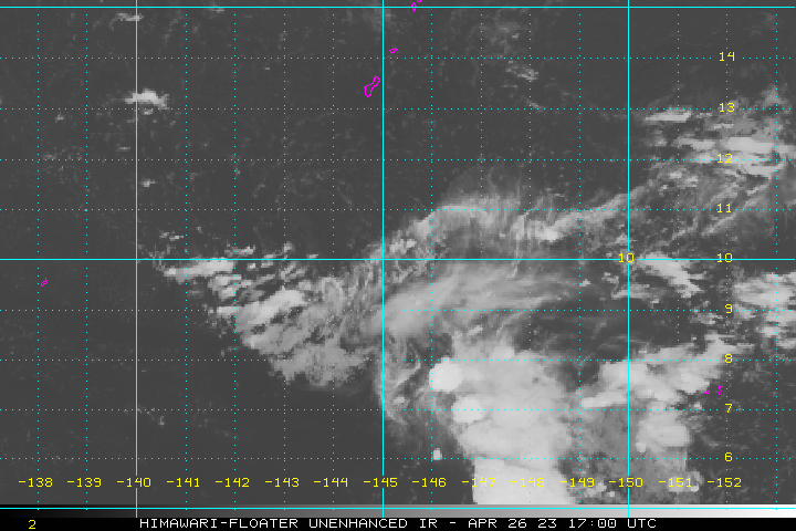
>>> Northwest Pacific Ocean: Tropical cyclone 01W (Mekkhala) remains active in the western Pacific. Here’s the JTWC graphical track map for this slowly strengthening tropical storm. Here’s the NOAA satellite image of this system…to the north of Yap Island.
>>> South Pacific Ocean: There are no active tropical cyclones
>>> North and South Indian Oceans: Tropical cyclone 05S (Bansi) remains active in the south Indian Ocean. Here’s the JTWC graphical track map for this strengthening tropical cyclone. Here’s the NOAA satellite image of this system…to the northeast of La Reunion Island.
Here’s a link to the Joint Typhoon Warning Center (JTWC)
Interesting: Sudden global warming 55 million years ago was much like today – The Earth’s current warming is looking similar to what took place 55 million years ago, writes David Bond. And if it works out that way, the news is good: we may avoid a mass extinction. On the other hand, the poles will melt away completely, and it will take hundreds of thousands of years for Earth to get back to ‘normal’.
It is often said that humans have caused the Earth to warm at an unprecedented rate.
However researchers have discovered another period, some 55m years ago, when massive volcanic eruptions pumped so much carbon into the atmosphere that the planet warmed at what geologists would think of as breakneck speed.
The good news is that most plants and animals survived the warm spell. The planet has experienced several mass extinctions – and this wasn’t one of them.
But there’s a catch: even after carbon levels returned to their previous levels, the climate took 200,000 years to return to normal.
Geologists have a name for this earlier period of sudden warming: the Palaeocene-Eocene Thermal Maximum. The PETM, as we’ll call it, occurred 55.5-55.3 million years ago.
According to new research published in the journal Nature Geoscience it involved global warming of between 5 and 8°C over a period of 200,000 years.
The massive carbon injections responsible for the PETM probably originated in volcanic eruptions in the North Atlantic and the burning of organic-rich rocks through which lava passed, which further triggered the melting of frozen methane stored at the bottom of the deepest oceans.
Lessons from the PETM
There are obvious analogies between the PETM and the present-day situation, even despite the lack of fossil-fuel burning humans 55m years ago.
The study shows the PETM was caused by annual carbon emissions of at least 900 million tons (900 MT) over the 200,000 years. That is ten times less than the 9500 MT carbon humans are releasing into the atmosphere every year. Surely cause for concern?
However, it is a little misleading to suggest emissions of just 10% of current levels resulted in warming of 5°C or more. It is possible to zoom out too far, even when assessing climate change.
Considering that CO2 only sticks around in the atmosphere for 1,000 years at most, to achieve as much as 8°C warming the bulk of PETM carbon must have been delivered to the atmosphere in a very short time, during which the long-term average was greatly exceeded.
The researchers identify two such ‘pulses’, each lasting no more than 1,500 years. Volcanic eruptions are not predictable – and certainly not consistent – but they would fit the profile of these ‘pulses’.
It is these massive, rapid injections of carbon into the atmosphere that overwhelmed Earth’s otherwise extremely efficient oceanic carbon sink: it takes time to deal with such blows.
The study suggests that it took 200,000 years before Earth returned to normal (probably hindered by volcanic eruptions) – a duration that suggests Earth will not recover from its current stresses any time soon.
‘Nice’ warming?
An intriguing aspect of the PETM warming is that there was no mass extinction. Perhaps ecosystems were resilient having evolved in the aftermath of the great extinction of the dinosaurs some 10m years earlier. Perhaps the warming didn’t last long enough. Perhaps warming just made things ‘nice’.
But global warming hasn’t usually been particularly good news for the planet’s inhabitants. When massive volcanic eruptions in present-day Siberia generated a comparable increase in global temperature 250m years ago, it caused the greatest crisis in Earth’s history.
Around 95% of the planet’s species were wiped out in what is known as the Permian-Triassic extinction, or the Great Dying. Earth was definitely not ‘nice’ and remained inhospitably hot for millions of years. In comparison, the PETM looks like a tea party.
Is humankind off the hook? After all, we are only emitting a bit of carbon each year, nothing like the massive doses administered by enormous eruptions in geological history. No.
The excellent high-resolution palaeoclimate records now emerging indicate that global warming has precedent in the rock record, and it always takes Earth a long time to recover.
The impact of 5-8°C global warming today is hard to define. It is beyond the worst-case scenarios of most climate models – and yet it is not beyond the bounds of possibility.
Time to decide the future Earth we want
Let’s do some rough calculations – and simplify things by talking about CO2 alone: today, Earth’s atmosphere contains at least 3000 gigatons of CO2. Humans inject a further 30,000 megatons every year (1% of the mass in the atmosphere). Volcanoes add only a fraction of the human contribution.
By contrast, the total CO2 release from the Siberian Traps and the rocks burned by its lava is estimated at 30,000 to 100,000 gigatons. That’s ten to thirty times the total amount of carbon currently in the atmosphere.
At current rates it will take humans just 1,000 – 3,000 years to produce this amount (it took the Siberian Traps much longer) and by the year 3014 Earth could be facing another catastrophe. Does that sound a long time away? For a geologist, these are incredibly short timescales.
Our saving grace appears to be that we are coming out of an ice-age with an atmosphere relatively low in CO2, and that we are going to run out of fossil fuels before the above scenario can happen.
However, geologists have shown that massive injections of carbon to the atmosphere can change the climate quite rapidly, and we are already well along the road. We are now seeing major changes to our weather and time will tell if this is the manifestation of longer term climate change.
Undoubtedly Earth’s climate will change as we continue to emit. Our generation might not see the impact of that change, but we need to decide what we want for the future of Earth. It is time to learn from Earth’s past – episodes such as the PETM, and the Permian-Triassic – as we look to its future.
Judy Says:
Is the vog “heavier/thicker” at lower elevations (Kahului or Kihei) or at the higher elevations (Kula)?~~~Hi Judy, that’s a good question. Hmmm…you know, I’m not exactly sure. I’m thinking probably lower elevations, down near sea level. Anyone want to chime in here, and give their opinion? Aloha, Glenn
Barbara Says:
Aloha, Glenn,
Actually, I started out just wanting to know if Olowalu is a south shore or a west shore (I’m pretty sure it’s not east or north:-) But then I also read with interest your commentary on global warming – thank you – I’m going to send this to my dad in South Dakota – South Dakotans pretty much take a long view on everything.~~~Hi Barbara, good hearing from you! First of all, Olowalu is the west shore for the most part, although it faces towards the south too…lets say southwest. Yes, global warming, or what lots of people are calling global climate change. This title takes the charge off of it being so cold in winter, which sort of misleads people at times. At any rate, I’m happy that you visited my website, I hope you have a great vacation here on Maui. Hello to all those South Dakotans who may be reading too. Aloha…Glenn
Barbara