


Air Temperatures – The following maximum temperatures (F) were recorded across the state of Hawaii Wednesday:
85 Lihue, Kauai
88 Honolulu, Oahu
85 Molokai
89 Kahului, Maui
85 Kailua Kona
85 Hilo, Hawaii
Here are the latest 24-hour precipitation totals (inches) for each of the islands, as of Wednesday evening:
0.74 Mount Waialeale, Kauai
0.40 Oahu Forest NWR, Oahu
0.08 Molokai airport, Molokai
0.00 Lanai
0.00 Kahoolawe
0.10 Puu Kukui, Maui
0.80 Kawainui Stream, Big Island
The following numbers represent the strongest wind gusts (mph)…as of early Wednesday evening:
27 Port Allen, Kauai
35 Oahu Forest NWR, Oahu
27 Molokai
31 Lanai
31 Kahoolawe
29 Kahului AP, Maui
32 Kawaihae, Big Island
Hawaii’s Mountains – Here’s a link to the live web cam on the summit of near 13,800 foot Mauna Kea on the Big Island of Hawaii. This web cam is available during the daylight hours here in the islands…and when there’s a big moon shining down during the night at times. Plus, during the nights you will be able to see stars, and the sunrise and sunset too… depending upon weather conditions.
Aloha Paragraphs


Close-up satellite image of category 1 hurricane Iselle


Close-up satellite image of category 2 hurricane Julio
We’re Gonna Get Wet and Windy…be careful!
We have big changes in our wind speeds and directions coming
up…as two tropical cyclones move over, or close to the
Hawaiian Islands later Thursday through Friday – and
then again Sunday into next Monday
We’ll find tropical cyclone Iselle moving through the islands,
or at least close by…later Thursday into Friday
Here’s a real time wind profiler showing category 1 hurricane
Iselle to the east-southeast of Hawaii – here’s an animated
satellite image of Iselle
Tropical cyclone Julio is following closely in the wake of Iselle…
at hurricane strength as well – both of which will bring windy
and rainy weather our way…along with rising high surf
Hurricane Warning…today through Friday over Big Island
windward waters…southeast waters – and the Big Island itself
(Hurricane warnings indicate that hurricane conditions (sustained winds
of 74 mph or higher) are expected somewhere within the specified area)
Tropical Storm Warning…in effect for the islands of Maui County
and surrounding waters, as well as for Oahu…and surrounding
waters…and Kaiwi Channel…and Kauai NW waters, windward
waters, and Kauai Leeward waters
Tropical Storm Watch…for Kauai and Niihau
(A tropical storm warning is issued when the following conditions are imminent
within 24 hours or are occurring: storm surge, coastal flooding, river flooding
and winds of 39 to 73 mph.
A tropical storm watch is issued when these conditions are possible within
36 hours, but it doesn’t mean they will occur)
Flash Flood Watch…for the entire State of Hawaii – Tropical cyclone Iselle
will bring heavy rains to the islands…from 4am today – 6am Saturday
Precautionary/preparedness actions
For those under a warning, your preparations to protect life and property should be rushed to completion. In a tropical cyclone, conditions can change quickly. Evacuate if directed to do so by local officials, or if your home is vulnerable to high winds or flooding. Cancel any beach activities until further notice. Persons living near the shore should be prepared to evacuate quickly should building surf threaten.
For those under a watch, now is the time to prepare. Do not wait until it is too late. Stay calm and keep informed.
It is vital that you do not focus on the exact forecast track. Forecast movement, direction, and speed are only estimates. Even small errors in the forecast track can mean major differences in where the worst conditions will occur. Damaging effects can extend far from the center.
Be ready to evacuate if necessary. Heed the advice of local officials and comply with any orders that are issued. Persons living near the shore should be prepared to evacuate quickly should building surf threaten.
At ports, docks, and marinas, perform the prescribed preparations according to your emergency operations plan. If you live on a boat, begin to safely secure your craft and make plans to leave it for adequate land based shelter.
Small craft should return to port or seek safe harbor.
Loose objects such as lawn furniture, garbage cans, and other items should be secured or stored indoors. Have supplies on hand and be ready for power outages. Evacuate if ordered by local officials.
Tropical storms can bring very heavy rain leading to flash flooding. People near streams, rivers, and low-lying flood prone areas are urged to be especially alert to flash flooding.
~~~ Hawaii Weather Narrative ~~~
Our trade winds will gradually give way to strong and blustery conditions…with very strong gusts later Thursday into Friday. Here’s the latest weather map, showing the Hawaiian Islands, and the rest of the North Pacific Ocean, along with a real-time wind profile of the central Pacific…focused on the Hawaiian Islands. We have a moderately strong high pressure system located to the northeast of the state, with a ridge of high pressure extending west-southwest…to the north of Hawaii. Our winds will begin going through some definite changes as hurricane Iselle continues to get closer to the Big Island later Thursday, and then the other islands will come under attack by this air in a hurry on Friday.
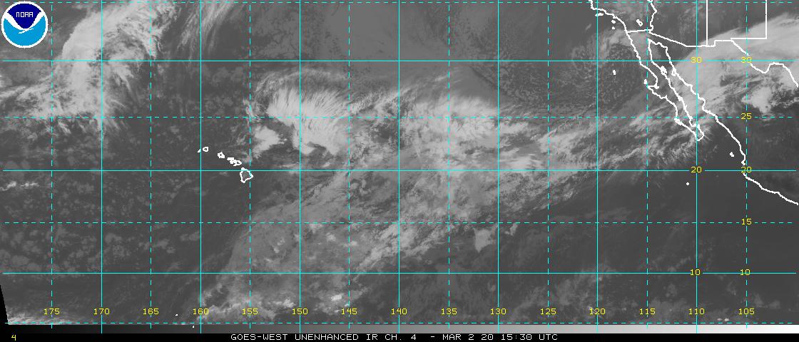
Satellite imagery shows scattered low level clouds over or around the islands…with category 1 hurricane Iselle to our east-southeast! Looking at this larger looping satellite image, it shows considerable thunderstorm activity over the ocean to the southwest through south of the state…the largest of these areas is Hurricane Geneieve far to Hawaii’s west-southwest. The spinning clouds associated with category 1 hurricane Iselle are evident on the right side of that animated image…which continues to take aim on our fragile islands. Here’s the looping radar, showing scattered showers falling locally along the windward sides and around the mountains, which are somewhat more active now than they have been the last several days.
A big change in our local weather conditions is on the horizon…Hawaiian Islanders should be making preparations for very unusual conditions. Category 1 hurricane Iselle continues to take aim on the southern part of the Hawaiian Islands…and will become the primary weather feature later Thursday into Friday. The latest forecast has Iselle continuing to be a hurricane as she impacts the Big Island, that…or as a strong tropical storm. Thereafter, and as this Central Pacific Hurricane Center’s official track map on Iselle shows, our islands will have this storm moving by close to the south of the other islands through Friday.
The models are showing yet another tropical cyclone moving westward into the central Pacific, a couple of days behind Iselle. This next system is a hurricane named Julio. Julio could bring another round of heavy weather to the islands later this coming weekend into early next Monday. In sum, we’ll see wet and blustery weather, with potentially damaging high surf conditions (east shores) during the Thursday-Friday time frame, and then again possibly later this weekend as Julio moves by to our north…please find more information just below. I’ll be back with more updates on all of the above and below, I hope you have a great Wednesday evening wherever you happen to be spending it! Aloha for now…Glenn.
~~~ Category 1 hurricane Iselle: Is moving west-northwestward towards the Big Island. The latest Central Pacific Hurricane Center (CPHC) estimate of sustained winds is 80 mph near the center, with stronger gusts to near 98 mph. It will likely remain a hurricane until just before striking the southeast or east coast of the Big Island. As landfall is made, Iselle will probably weaken to a tropical storm shortly thereafter, as it migrates by just to the south of the other islands through Friday. When a storm’s maximum sustained winds reach 74 mph, it’s called a hurricane. A tropical storm is an organized system of strong thunderstorms with a defined surface circulation and maximum sustained winds between 39 and 74 mph. Rainfall will likely be a major issue, which could lead to serious flooding in some areas. We’ll also see high surf arriving ahead of this hurricane…breaking largest along the east facing shores.
World-wide tropical cyclone activity:
Atlantic Ocean: There are no active tropical cyclones
Here’s a satellite image of the Atlantic Ocean
Caribbean Sea: There are no active tropical cyclones
Gulf of Mexico: There are no active tropical cyclones
Here’s a satellite image of the Caribbean Sea…and the Gulf of Mexico.
Here’s the link to the National Hurricane Center (NHC)
Eastern Pacific: Hurricane 10E (Julio) is active at the category 2 level in the NE Pacific Ocean, here’s the NHC graphical track map…along with a satellite image
Here’s a wide satellite image that covers the entire area between Mexico, out through the central Pacific…to the International Dateline.
Central Pacific: Hurricane 09E (Iselle) remains active at the category 1 level, located about 305 miles east-southeast of Hilo, Hawaii, here’s the CPHC graphical track map…along with a satellite image
Here’s a link to the Central Pacific Hurricane Center (CPHC)
Northwest Pacific Ocean: Super Typhoon 07E (Genevieve) remains active far to the west-southwest of the Hawaiian Islands as a category 5 tropical cyclone…here’s the JTWC graphical track map…along with a satellite image
Typhoon 11W (Halong) remains active well to the northeast of the Philippine Islands, here’s the JTWC graphical track map…along with a satellite image.
South Pacific Ocean: There are no active tropical cyclones
North and South Indian Oceans: There are no active tropical cyclones
Here’s a link to the Joint Typhoon Warning Center (JTWC)
Interesting: Mercury in the oceans increasing – Mercury is a naturally occurring element as well as a by-product of such distinctly human enterprises as burning coal and making cement. Estimates of “bioavailable” mercury – forms of the element that can be taken up by animals and humans – play an important role in everything from drafting an international treaty designed to protect humans and the environment from mercury emissions, to establishing public policies behind warnings about seafood consumption.
Yet surprisingly little is known about how much mercury in the environment is the result of human activity, or even how much bioavailable mercury exists in the global ocean. Until now.
A new paper by a group that includes researchers from the Woods Hole Oceanographic Institution (WHOI), Wright State University, Observatoire Midi-Pyréneés in France, and the Royal Netherlands Institute for Sea Research appears in this week’s edition of the journal Nature and provides the first direct calculation of mercury in the global ocean from pollution based on data obtained from 12 sampling cruises over the past 8 years. The work, which was funded by the U.S. National Science Foundationand the European Research Council and led by WHOI marine chemist Carl Lamborg, also provides a look at the global distribution of mercury in the marine environment.
Analysis of their results showed rough agreement with the models used previously – that the ocean contains about 60,000 to 80,000 tons of pollution mercury. In addition, they found that ocean waters shallower than about 100 m (300 feet) have tripled in mercury concentration since the Industrial Revolution and that the ocean as a whole has shown an increase of roughly 10 percent over pre-industrial mercury levels.
“With the increases we’ve seen in the recent past, the next 50 years could very well add the same amount we’ve seen in the past 150,” said Lamborg. “The trouble is, we don’t know what it all means for fish and marine mammals. It likely means some fish also contain at least three times more mercury than 150 years ago, but it could be more. The key is now we have some solid numbers on which to base continued work.”
“Mercury is a priority environmental poison detectable wherever we look for it, including the global ocean abyss,” says Don Rice, director of the National Science Foundation (NSF)’s Chemical Oceanography Program, which funded the research. “These scientists have reminded us that the problem is far from abatement, especially in regions of the world ocean where the human fingerprint is most distinct.”
Maggie Says:
Aloha, Glenn! Well, it’s 9AM and we’ve already gotten 0.6″ of rain from the moisture being shoved ahead of the storm. This is going to be a wet one! We’re in the shadow of Giggle Hill and the trade winds tend to swirl around it in random and unpredictable ways – one gust from the east and the next may be from the south. It will be interesting to see how it deflects the storm winds. I’m looking forward to your periodic reports over the next couple of days. Let’s hope the power stays on! Oh, and I’d advise against skateboarding today… :)~~~Hi Maggie, chuckling in the face of the approaching storm. It’s raining up here in Kula too, getting windy as well. I’m hoping the power stays on too, main thing that! Hang in there, be safe! Aloha…Glenn.
Cari gallo Says:
Hello Glenn! We are flying direct from Denver to Maui on Sunday arriving about 3pm!!! What are your thoughts??? Will planes fly??? Is it safe??? What are your thoughts
Thank you~~~Hello Cari, the planes will not fly into the islands unless it is safe, if you get on an airplane destined for Maui, and take off from Denver, you will be fine, they don’t fly into dangerous situations here in Hawaii. Aloha, Glenn
Steve Says:
Good morning Glenn. No time for you to spend on mahalo’s, but my best to you and the islands as you greet Iselle and Julio. Your reports and narratives are always appreciated, my friend. Aloha, Glenn. Hang in there.~~~Hi Steve, good to hear from you again, thanks for your sincere good thoughts, they are appreciated! Aloha, Glenn
Tracey Says:
Hi Glenn, My family and I have been planning our first trip to the Big Island and Maui since January scheduled to arrive next Thursday (14th) on the Big Island and then off to Maui after 5 days. We are so excited, yet quite naive to this area. Is it safe to assume the weather will be a tad quieter by the time we arrive? We are coming from Minnesota so are quite accustom to extreme weather patterns and can certainly be flexible with our plans and won’t let a little rain slow us down but thought your insight would be nice. We are definitely looking forward to just relaxing and hanging loose but would certainly be disappointed if we couldn’t experience all of the great outdoors your state has to offer. And, my daughter can’t wait to learn how to surf!!~~~Hi Tracey, things will have quieted down by then, and you will have a great vacation here in Paradise…have a wonderful experience! The outdoors will welcome you with open arms, no doubt. Aloha, Glenn
Jack Says:
Hi Glenn, We went up the Twin Sisters together in Wa. about 30 years ago after our 3 month sitting stay at Maui Z. You were a great help then and wanted to say belated ‘THANKS’.
Was just checking Hawaii storm weather and saw your face.
Aloha…
warmly
Jack~~~Hi Jack, how wonderful to hear from you, after all these years! So good to know you saw my face, remembered my name, and actually took the time to write…thanks! I went to your website, and remember your face too, nice to see you are a Zen Master in the PNW. I’ve continued my Zen sitting all these years as well, and start each day that way. I’d love to visit you folks sometime, and will keep your website handy. Hope you found what you were looking for in terms of these storms that are bearing down on Hawaii. Take care of yourself! Aloha, Glenn