


Air Temperatures – The following maximum temperatures (F) were recorded across the state of Hawaii Monday:
84 Lihue, Kauai
87 Honolulu, Oahu
84 Molokai
87 Kahului, Maui
86 Kailua Kona
77 Hilo, Hawaii
Air Temperatures ranged between these warmest and coolest spots near sea level – and on the highest mountain tops on Maui and the Big Island…as of 830pm Monday evening (HST):
Kailua Kona – 81
Hilo, Hawaii – 70
Haleakala Summit – 50 (near 10,000 feet on Maui)
Mauna Kea Summit – 37 (13,000+ feet on the Big Island)
Hawaii’s Mountains – Here’s a link to the live web cam on the summit of near 13,800 foot Mauna Kea on the Big Island of Hawaii. This web cam is available during the daylight hours here in the islands…and when there’s a big moon shining down during the night at times. Plus, during the nights you will be able to see stars, and the sunrise and sunset too… depending upon weather conditions.
Aloha Paragraphs

Trade winds picking up…remaining active through the rest of
this work week – then come down a notch this weekend
There will be some passing showers along the windward sides,
mostly at night…a few elsewhere around the state
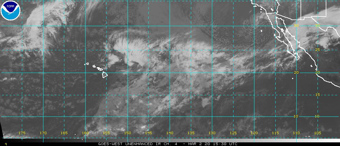
Looping satellite image showing lots of high cirrus clouds
moving by to our southeast…and around the Big Island
Small Craft Wind Advisory…windiest coasts and channels
around Maui County and the Big Island
The following numbers represent the strongest wind gusts (mph), along with directions…as of Monday evening
21 Port Allen, Kauai – NE
23 Oahu Forest NWR, Oahu – NNE
29 Molokai – SE
35 Lanai – NE
32 Kahoolawe – NE
25 Kapalua, Maui – NE
25 Waikoloa, Big Island – NE
Here are the latest 24-hour precipitation totals (inches) for each of the islands…as of Monday evening (545pm totals):
0.64 Mount Waialeale, Kauai
1.09 Manoa Lyon Arboretum, Oahu
0.20 Molokai
0.06 Lanai
0.00 Kahoolawe
1.97 Puu Kukui, Maui
0.89 Kawainui Stream, Big Island
We can use the following links to see what’s going on in our area of the north central Pacific Ocean. Here’s the latest NOAA satellite picture – the latest looping satellite image… and finally the latest looping radar image for the Hawaiian Islands.
~~~ Hawaii Weather Narrative ~~~
Moderately strong trade winds…increasing some later Tuesday. Here’s the latest weather map, showing the Hawaiian Islands, and the rest of the North Pacific Ocean, along with a real-time wind profile of the central Pacific…focused on the Hawaiian Islands. We have moderately strong high pressure systems located to the northeast of the state. The models suggest that the trade winds will remain active, with no definite end in sight through the next week at least.
Satellite imagery shows high cirrus clouds around the state now. Looking at this larger looping satellite image, it shows low level clouds riding along in the trade wind flow from east to west, under these high clouds. There’s an area of high cirrus clouds near Kauai, and at the same time…there’s an area of high clouds racing by to our south and very close to the Big Island. The high clouds over Hawaii will dim and filter our Hawaiian sunshine at times, as well as give us a nice sunset this evening…and or sunrise on Tuesday. Here’s the looping radar, showing passing showers, which increased last night, but diminished again today, and will likely increase some tonight again.
Favorably inclined weather conditions, with little change through Saturday. The trade winds will be picking up later Tuesday onwards. As is often the case, most showers that grace our shores and slopes will occur during the night and early morning hours. There are those typical patches of showery clouds upstream, which will bring moisture our way periodically through the week. The trade winds will be strong enough to carry a few passing showers over to the leeward sides at times too. The nighttime hours will find the most frequent shower activity, into Tuesday morning. I’ll be back early Tuesday morning with your next new weather narrative, I hope you have a great Monday night wherever you’re spending it! Aloha for now…Glenn.
Tropical storm Fausto, the 6th tropical cyclone of the hurricane season…has spun-up in the northeastern Pacific. This storm isn’t expected to attain hurricane strength, although it’s claim to fame may be that it’s able to push into our central Pacific by Friday. I expect it to rather quickly weaken once that happens, coming down into a tropical depression status, or even as a remnant low pressure system into the weekend. It wouldn’t be out of the question to have it bring some tropical showers our way later in the weekend…or early next week. At this point, I’d say that we have nothing to worry about, in terms of strong winds, although it would be wise to stay tuned. Here’s the NHC graphical track map, a satellite image…and what the computer models are showing for this storm.
Here on Maui, at the 3,100 foot elevation, at my upper Kula, Maui weather tower, the air temperature was a 59.5 degrees at 610am on this Monday morning. Skies are partly cloudy, with high cirrus clouds still around today. The more generous clouds over along the windward sides look showery, and here in Kula, I can see that there were a few very light showers last night too…as my weather deck is wet this morning.
We’re into the early afternoon at 1205pm, under cloudy skies, light winds…and an air temperature of 73.2 degrees.
It’s now early Monday evening at 535pm, under partly sunny skies, light breezes…and an air temperature of 83.5 degrees. It turned out to be another very nice sunset, with high cirrus mix with some middle level altocumulus…which was beautiful.
World-wide tropical cyclone activity:
Atlantic Ocean: There are no active tropical cyclones expected through the next 5 days
Here’s a satellite image of the Atlantic Ocean
Caribbean Sea: There are no active tropical cyclones expected through the next 2 days
Gulf of Mexico: There are no active tropical cyclones expected through the next 2 days
Here’s a satellite image of the Caribbean Sea…and the Gulf of Mexico.
Here’s the link to the National Hurricane Center (NHC)
North Eastern Pacific: Tropical Storm Fausto remains active, here’s the NHC graphical track map…and a satellite image. Here’s what the latest computer models are showing.
Meanwhile, there continues to be a broad low pressure system, located several hundred miles southwest of Manzanillo, Mexico, continues to produce disorganized showers and thunderstorms. Development, if any, of this system should be slow to occur during the next 48 hours as it moves west-northwestward at 10 to 15 mph. After 48 hours, upper level winds are expected to become less conducive for development.
This area is being referred to as Invest 98E.
* Formation chance through 48 hours…low…20 percent
* Formation chance through 5 days…low…20 percent
Here’s a wide satellite image that covers the entire area between Mexico, out through the central Pacific…to the International Dateline.
Central Pacific Ocean: No tropical cyclones are expected through the next two days
Here’s a link to the Central Pacific Hurricane Center (CPHC)
Northwest Pacific Ocean: Typhoon 08W (Neoguri) remains active, and will be gradually weakening over the next several days…moving by near Okinawa and then across Japan. Here’s the JTWC graphical track map…along with a satellite image.
South Pacific Ocean: There are no active tropical cyclones
North and South Indian Oceans: There are no active tropical cyclones
Here’s a link to the Joint Typhoon Warning Center (JTWC)
Interesting: Condors vs. the NRA – Recently scientists from the Zoological Society of London and Yale University assessed the world’s 9,993 bird species according to their evolutionary distinctiveness and global extinction risk.
At number three on the list is the Critically Endangered California condor (Gymnogyps californianus) – weighing as much as 25 pounds, standing over four foot tall, with a wingspan of almost 10 feet, it is the largest land bird in North America.
Riding on wind currents to heights of 15,000 feet and travelling up to 150 miles a day in search of food, these majestic birds once flew by the thousands above the California land mass and far beyond.
The condor flies again
Sadly, condor numbers dropped so drastically that in 1987 the last living wild condor was taken into captivity and put into a breeding program to save the species.
Now only 238 free-ranging condors – all descendants of captive breeding in the Condor Recovery Program initiated in the early 1980s -inhabit the skies above California, Arizona, Utah, and Baja California. A further 195 are in zoos, captive breeding programs, or being held for release or medical treatment.
This is a far cry from sustainable population numbers but it is also far better than the numbers in April 1987 through 1991 when the North American skies were empty of condors.
Although one of the very first species listed under the Endangered Species Protection Act of 1966, condor populations plummeted for decades. How did things go so wrong?
Humans took a heavy toll: habitat loss and destruction, hunting, egg and specimen collecting, the capturing of live birds, ingestion of DDE (a breakdown form of the pesticide DDT), accidental ingestion of lead from spent ammunition and other assaults, decimated the species’ numbers to the point of near extinction.
A third of condors suffer from lead poisoning
Today, most of these problems have been ameliorated. But one huge hazard remains: the leading cause of mortality to condor populations and the number one threat to condor recovery is still lead poisoning from spent ammunition.
A 2012 study by the University of California at Santa Cruz by Myra Kinkelstein and others found that “condors in California remain chronically exposed to harmful levels of lead.”
“30% of the annual blood samples collected from condors indicate lead exposure that causes significant sub-clinical health effects … Furthermore, each year, ~20% of free-flying birds have blood lead levels that indicate the need for clinical intervention to avert morbidity and mortality.”
maggie Says:
Aloha Glenn. A few on-off showers last night sent our rain gauge over 55″ for the year (we’re on Maliko Gulch opposite Giggle Hill – so on the drier corner of Haiku). With that reading, we have surpassed the full-year total for 2013. It’s been a soggy first half of 2014 !!
Many thanks for your daily efforts with this site. I always enjoy reading your missives – even when I’m back working in NY. Fortunately, I’m here more than there!!
Much aloha!~~~Hi Maggie…how interesting! I know Maliko Gulch very well, as I’ve driven through it literally 1000’s of times over the years. This wet weather is good news, at least in terms of pushing the drought conditions back…we needed that rain. Working in NY, and living here on Maui at times too, sounds fun to me. Thanks for sharing your rain gauge news, and for appreciating what I do with this website too! Aloha, Glenn