


Air Temperatures – The following maximum temperatures (F) were recorded across the state of Hawaii Wednesday:
82 Lihue, Kauai
87 Honolulu, Oahu
83 Molokai
89 Kahului, Maui
86 Kailua Kona
80 Hilo, Hawaii
Air Temperatures ranged between these warmest and coolest spots near sea level – and on the highest mountain tops on Maui and the Big Island…as of 543pm Wednesday evening:
Kailua Kona – 85
Hilo, Hawaii – 78
Haleakala Summit – 50 (near 10,000 feet on Maui)
Mauna Kea Summit – 43 (13,000+ feet on the Big Island)
Hawaii’s Mountains – Here’s a link to the live web cam on the summit of near 13,800 foot Mauna Kea on the Big Island of Hawaii. This web cam is available during the daylight hours here in the islands…and when there’s a big moon shining down during the night at times. Plus, during the nights you will be able to see stars, and the sunrise and sunset too… depending upon weather conditions.
Aloha Paragraphs

Trade winds will continue…easing up
some this weekend
There will be some passing showers
generally along the windward
sides…a few elsewhere
Small Craft Wind Advisory…over
the windiest coasts and channels
around Maui County – Big Island
The following numbers represent the strongest wind gusts (mph), along with directions…as of Wednesday evening:
24 Port Allen Kauai – NE
40 Oahu Forest NWR, Oahu – NNE
28 Molokai – NE
42 Lanai – NE
31 Kahoolawe – NE
31 Kahului, Maui – NE
35 PTA Keamuku, Big Island – NE
Here are the latest 24-hour precipitation totals (inches) for each of the islands…as of Wednesday evening (545pm totals):
2.05 Mount Waialeale, Kauai
0.72 Kahana, Oahu
0.08 Molokai
0.00 Lanai
0.00 Kahoolawe
0.19 Puu Kukui, Maui
1.44 Honaunau, Big Island
We can use the following links to see what’s going on in our area of the north central Pacific Ocean. Here’s the latest NOAA satellite picture – the latest looping satellite image… and finally the latest looping radar image for the Hawaiian Islands.
~~~ Hawaii Weather Narrative ~~~
Gusty trade winds will prevail…becoming softer this weekend. Here’s the latest weather map, showing the Hawaiian Islands, and the rest of the North Pacific Ocean, along with a real-time wind profile of the central Pacific…focused on the Hawaiian Islands. We have two moderately strong high pressure systems located to the north and northeast. These high pressure cells have associated ridges extending southwest and southeast of the state. Our local winds will remain gusty, with only minor daily variations in speed and direction through the next few days. Those places with the most direct exposure to this wind flow will top 40 mph in gusts in a few places during the days…lighter at night. A fairly minor reduction in wind speeds will take place this weekend, although they will continue on well into the future.
Satellite imagery shows just a few scattered clouds around the islands…otherwise mostly clear skies. Looking at this larger looping satellite image, we see areas of high level clouds to our south and southeast…moving by well south of the Big Island at the moment. In addition, there’s an area of thunderstorms well to the west of Hawaii, associated with a counterclockwise rotating, upper level low pressure system. Meanwhile, the lower level clouds are riding along in the trade wind flow…impacting our windward sides at times locally. Here’s a looping radar image, showing showers moving from right to left, carried by the trade winds. They decreased greatly during the day…although will likely increase to some degree again tonight into early Thursday morning.
We continue to be involved in a well established trade wind weather pattern…as we push towards the beginning of the summer season Friday night. There will be some showers reaching the windward sides of our islands, although nothing overbearing is expected. As a matter of fact generally normal amounts of shower activity will continue for the most part…through the next week. The leeward sides, as is often the case under these conditions, will continue to be very nice weather-wise. I’ll be back early Thursday morning with your next new weather narrative, I hope you have a great Wednesday night wherever you’re spending it! Aloha for now…Glenn.
Here on Maui, at the 3,100 foot elevation, at my upper Kula, Maui weather tower, the air temperature was 55.2 degrees at 555am on this Wednesday morning. Skies are clear overhead and down through the leeward beaches. There are a few clouds hugging the windward sides this morning, although there’s nothing in the world unusual about that. All things considered, we’ll find great weather through these last two full days of the spring season.
We’re now into the early afternoon at 1230pm, under clear to partly cloudy skies, light breezes…and an air temperature of 76.3 degrees.
Now we’re into the early evening hours at 610pm, under mostly clear skies, light winds…and a warm air temperature of 80.6 degrees. What can I say? Well, I suppose that today was the epitome of summer, although…summer hasn’t quite arrived. It’s just before sunset, and its one of the sunniest examples that we ever get, really really nice. It was almost as warm up here in Kula, as it was down country in Kahului!
World-wide tropical cyclone activity:
Atlantic Ocean: There are no active tropical cyclones expected through the next 5 days
Here’s a satellite image of the Atlantic Ocean
Caribbean Sea: There are no active tropical cyclones expected through the next 5 days
Gulf of Mexico: There are no active tropical cyclones expected through the next 5 days
Here’s a satellite image of the Caribbean Sea…and the Gulf of Mexico.
Here’s the link to the National Hurricane Center (NHC)
North Eastern Pacific: There are no active tropical cyclones expected through the next 5 days
Here’s a wide satellite image that covers the entire area between Mexico, out through the central Pacific…to the International Dateline.
Central Pacific Ocean: No tropical cyclones are expected through Saturday morning
Here’s a link to the Central Pacific Hurricane Center (CPHC)
Northwest Pacific Ocean: There are no active tropical cyclones
South Pacific Ocean: There are no active tropical cyclones
North and South Indian Oceans: There are no active tropical cyclones
Here’s a link to the Joint Typhoon Warning Center (JTWC)
Interesting: Are we close to bringing back supersonic travel? – Remember the Concorde? The supersonic passenger jet that flew from 1969 to almost 2000. It was not cost effective for the airlines, and extravagantly expensive for passengers. It was also cramped. The luxury was being able to fly from New York to London in about 3 hours!
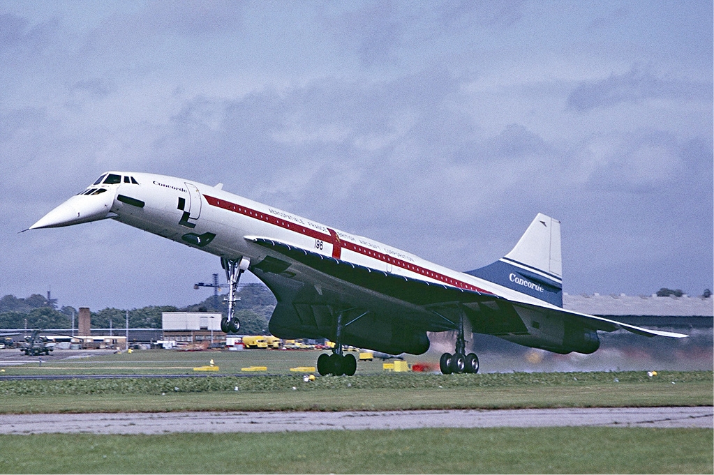
The Concorde had a big problem, the sonic boom it created when flying at supersonic speed. This led to governments restricting where it could fly supersonically and was a major factor in it not being economical to continue flying. That and a very advanced airframe that was getting old.
The return of supersonic passenger travel may be coming closer to reality thanks to NASA’s efforts to define a new standard for low sonic booms.
Several NASA aeronautics researchers will present their work in Atlanta this week at Aviation 2014, an annual event of the American Institute of Aeronautics and Astronautics. They will share with the global aviation community the progress they are making in overcoming some of the biggest hurdles to supersonic passenger travel.
The research generates data crucial for developing a low-boom standard for the civil aviation industry. NASA works closely with the Federal Aviation Administration and the international aerospace community, including the International Civil Aviation Organization, to gather data and develop new procedures and requirements that may help in a reconsideration of the current ban on supersonic flight over land.
“Lessening sonic booms — shock waves caused by an aircraft flying faster than the speed of sound — is the most significant hurdle to reintroducing commercial supersonic flight,” said Peter Coen, head of the High Speed Project in NASA’s Aeronautics Research Mission Directorate at the agency’s Headquarters in Washington. “Other barriers include high altitude emissions, fuel efficiency and community noise around airports.”
Engineers at NASA centers in California, Ohio and Virginia that conduct aviation research are tackling sonic booms from a number of angles, including how to design a low-boom aircraft and characterize the noise. NASA researchers have studied how to quantify the loudness and annoyance of the boom by asking people to listen to the sounds in a specially designed noise test chamber.
A recent flight research campaign at NASA’s Armstrong Flight Research Center in Edwards, California, had residents explore ways to assess the public’s response to sonic booms in a real-world setting. Researchers at Armstrong have an advantage — pilots are permitted to fly at supersonic speeds because the facility is located on Edwards Air Force Base.
“People here are more familiar with sonic booms,” said Armstrong aerospace engineer Larry Cliatt. “Eventually, we want to take this to a broader level of people who have never heard a sonic boom.”