


Air Temperatures – The following maximum temperatures (F) were recorded across the state of Hawaii Saturday:
83 Lihue, Kauai
84 Honolulu, Oahu
81 Molokai
88 Kahului, Maui
85 Kona, Hawaii
82 Hilo, Hawaii
Air Temperatures ranged between these warmest and coolest spots near sea level – and on the highest mountain tops on Maui and the Big Island…as of 1043pm Saturday evening:
Kailua Kona – 79
Hilo, Hawaii – 72
Haleakala Summit – 52 (near 10,000 feet on Maui)
Mauna Kea Summit – 39 (13,000+ feet on the Big Island)
Hawaii’s Mountains – Here’s a link to the live web cam on the summit of near 13,800 foot Mauna Kea on the Big Island of Hawaii. This web cam is available during the daylight hours here in the islands…and when there’s a big moon shining down during the night at times. Plus, during the nights you will be able to see stars, and the sunrise and sunset too… depending upon weather conditions. Here’s the Haleakala Crater webcam on Maui – if it’s working.
Aloha Paragraphs
Small Craft Wind Advisory for the channel between Oahu and
Molokai, and windy waters around Maui and the Big Island
Wind Advisory…over the Big Island summits
Locally strong trade winds, with off and on passing
windward showers…some in the leeward sections too
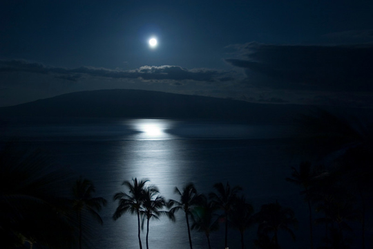
June Full Moon tonight…more information below
The following numbers represent the most recent top wind gusts (mph), along with directions as of Saturday evening:
29 Port Allen, Kauai – NE
38 Kuaokala, Oahu – NE
28 Molokai – ENE
31 Lanai – NE
42 Kahoolawe – ENE
37 Kahului, Maui -NE
30 Keaumo, Big Island – NNE
Here are the latest 24-hour precipitation totals (inches) for each of the islands as of Saturday evening:
1.88 Mount Waialeale, Kauai
1.21 Manoa Lyon Arboretum, Oahu
0.51 Molokai
0.00 Kahoolawe
0.00 Lanai
0.81 Puu Kukui, Maui
0.82 Kawainui Stream, Big Island
We can use the following links to see what’s going on in our area of the north central Pacific Ocean. Here’s the latest NOAA satellite picture – the latest looping satellite image… and finally the latest looping radar image for the Hawaiian Islands.
~~~ Hawaii Weather Narrative ~~~
Trade winds rather strong and gusty…then slightly lighter again starting Tuesday onwards. Here’s a weather chart showing a near 1028 millibar high pressure system located to the northeast of our islands…with another similar high pressure cell to the northwest. Our trade winds will strengthen a notch into Sunday, remaining locally strong and gusty into Monday. Looking further ahead, our trades will ease up a little Tuesday onwards.
Trade wind weather pattern will prevail, with off and on windward showers. Satellite imagery shows lots of high cirrus clouds over the state…and well to the south and east. Here’s a larger satellite picture showing the extent of these high cirrus. At lower levels, there’s patches of cumulus clouds surrounding the islands. Here’s the looping radar image, showing these showers passing by along our windward coasts and slopes, and over the offshore waters as well…with a few over the leeward sections on the smaller islands.
These common windward showers have been quite numerous during the last 24 hours or so. As we get into Sunday, and probably through Monday and Tuesday, these showers will calm down some. An unusual way out of season cloud band, or an old cold front called a shearline, may be pushed down into the state by mid-week, bringing back an increase in windward showers for a few days then. I’ll be back with your next new weather narrative Sunday morning, I hope you have a great Saturday night wherever you’re spending it! By the way, last evening I went to see a new film called Fast and Furious 6, which I found to be very entertaining! This evening, because its a full moon Saturday night, I’m taking the drive over to Kihei for some dancing. If I get in late my next narrative might be a bit later than normal, we’ll see how it goes. At any rate, I hope you enjoy the big full moon tonight, from wherever you happen to be watching it from! Aloha for now…Glenn.
Full moon youtube music video, Bobby Brown…Every Little Step – Full Screen is preferable
Supermoon – full early Sunday morning at 132am HST / The supermoon early June 23 (here in Hawaii) will be the full Moon event of 2013. The annual occurrence marks the Moon’s closest point to the Earth for the entire year.
The supermoon is not the technical term for the full Moon on June 23. Astronomers call this phenomenon a “perigee moon,” which describes the full moon that occurs when the moon is at its closest point to Earth each year. Perigee marks the closest point of a body as it orbits around Earth, while apogee marks the farthest point from Earth.
The apogee moon occurred on June 9, 2013 and in 2014 it will be farthest from Earth on July 28, 2014. The difference between perigee and apogee is just 30,000 miles as the farthest distance between the Earth and Moon is approximately 252,657 miles.
While there is no nickname for when the Earth is closest to the Sun, it has a technical name similar to the Moon’s naming conventions. The perihelion is when the Earth is closest to the Sun and that usually occurs in early January. An aphelion is the name for when the Earth is farthest from the Sun, and that usually occurs in early July.
Last year’s supermoon occurred on May 5, 2012, and June 23 marks the closest the Moon will get to Earth for the entire year. The next time the Moon will get as close to the Earth will be on Aug. 10, 2014. The Moon will look approximately 14 percent bigger and 30 percent brighter than the other full moons of 2012., according to NASA. While the Moon will be close to Earth, approximately 221,853 miles away, it will have no significant effect on Earth itself.
As Discovery News debunked in 2012, there is no connection between a supermoon and earthquakes, even though the belief goes as far back in history as the ancient Greeks. The casual link has become a part of folklore, but science has proved there is no connection between where the Moon is, in relation to the Earth, and the natural phenomenon. For seismic activity, there are simply too many variables to blame an earthquake on the Moon.
The supermoon will create some tidal changes, but that’s because it’s getting help from the Sun. Over the weekend, the Sun, Earth and Moon will line up in a near-straight line. The Sun and Moon’s gravitational pull will increase high tide and decrease low tide but any change will differ based on location.
As for witnessing the supermoon, it is as easy as going outside and looking up.
World-wide tropical cyclone activity:
Atlantic Ocean: There are no active tropical cyclones
TROPICAL CYCLONE FORMATION IS NOT EXPECTED DURING THE NEXT 48 HOURS
Caribbean Sea: There are no active tropical cyclones
TROPICAL CYCLONE FORMATION IS NOT EXPECTED DURING THE NEXT 48 HOURS.
Gulf of Mexico: There are no active tropical cyclones
TROPICAL CYCLONE FORMATION IS NOT EXPECTED DURING THE NEXT 48 HOURS
Eastern Pacific: There are no active tropical cyclones
SHOWER AND THUNDERSTORM ACTIVITY HAS INCREASED AND BECOME BETTER ORGANIZED IN ASSOCIATION WITH A LOW PRESSURE SYSTEM LOCATED ABOUT 450 MILES SOUTH OF MANZANILLO MEXICO. ENVIRONMENTAL CONDITIONS ARE CONDUCIVE FOR ADDITIONAL DEVELOPMENT…AND THIS LOW COULD BECOME A TROPICAL DEPRESSION BY SUNDAY MORNING. THIS SYSTEM HAS A HIGH CHANCE…NEAR 100 PERCENT…OF BECOMING A TROPICAL CYCLONE DURING THE NEXT 48 HOURS WHILE IT MOVES WEST-NORTHWESTWARD AT 5 TO 10 MPH.
AN AREA OF LOW PRESSURE CENTERED ABOUT 650 MILES SOUTH-SOUTHWEST OF THE SOUTHERN TIP OF BAJA CALIFORNIA CONTINUES TO PRODUCE A SMALL AREA OF SHOWERS AND THUNDERSTORMS. SOME DEVELOPMENT OF THIS SYSTEM IS POSSIBLE BEFORE UPPER-LEVEL WINDS INCREASE IN A DAY OR TWO. THIS SYSTEM HAS A MEDIUM CHANCE…30 PERCENT…OF BECOMING A TROPICAL CYCLONE DURING THE NEXT 48 HOURS WHILE IT MOVES LITTLE.
Elsewhere, tropical cyclone formation is not expected during the next 48 hours
Here’s a wide satellite image that covers the entire area between Mexico, out through the central Pacific…to the International Dateline.
Central Pacific Ocean: There are no active tropical cyclones
Here’s a link to the Central Pacific Hurricane Center (CPHC)…covering our central Pacific.
No Tropical cyclones are expected through Monday night
Western Pacific Ocean: Tropical depression 05W (Bebinca) has been located in the Gulf of Tonkin, and is making landfall along the far northeastern coast of Vietnam at the time of this writing…located about 75 NM southeast of Hanoi, Vietnam. Winds are light around the center of this fading tropical cyclone, although rainfall will be of concern, as the unwinding cyclone makes its tropical moisture felt inland during the next 24 hours our so. Here’s the JTWC graphical track map. – Final Warning
South Pacific Ocean: There are no active tropical cyclones
North and South Indian Oceans: There are no active tropical cyclones
Interesting: The fruits and vegetables we buy in the grocery store are actually still alive and according to new research from Rice University and the University of California at Davis, produce may be healthier for us depending on the time of day. “Vegetables and fruits don’t die the moment they are harvested,” said Rice biologist Janet Braam, lead researcher of the study.
Once picked, produce can continue to metabolize and survive independently for some time. Even when they are cut, their cells remain active and alive. “They respond to their environment for days, and we found we could use light to coax them to make more cancer-fighting antioxidants at certain times of day,” says Braam who is also a professor and chair of Rice’s Department of Biochemistry and Cell Biology.
Braam’s team shows that post-harvest vegetables and fruits can continue to perceive light and, as a result, their biological clocks keep on ticking. This is an advantage to the plants because it allows them to alter levels of important chemicals that protect them from being eaten by insects and other herbivores, the researchers found. This includes the process of ripening as these fruits and vegetables will often wait to ripen until their seeds are mature enough to germinate.
The research also shows that when it comes to human consumption, post-harvest fruits and vegetables may contain higher levels of phytochemicals at different times, which have have anti-cancer effects.
Braam’s team simulated day-night cycles of light and dark to control the internal clocks of fruits and vegetables, including cabbage, carrots, squash and blueberries.
“Vegetables and fruits, even after harvest, can respond to light signals and consequently change their biology in ways that may affect health value and insect resistance,” says Braam. “Perhaps we should be storing our vegetables and fruits under light-dark cycles and timing when to cook and eat them to enhance their health value.”
While the science indicates we may want to consider our foods’ daily schedules when deciding what time to eat them, this may not be convenient to the average family. However, “It may be of interest to harvest crops and freeze or otherwise preserve them at specific times of day, when nutrients and valuable phytochemicals are at their peak,” Braam says.