


Air Temperatures – The following maximum temperatures were recorded across the state of Hawaii Saturday:
82 Lihue, Kauai
80 Honolulu, Oahu
83 Molokai
89 Kahului, Maui
85 Kona, Hawaii
80 Hilo, Hawaii
Air Temperatures ranged between these warmest and coolest spots near sea level – and on the highest mountain tops around the state… as of 930pm Saturday evening:
Kailua Kona – 77
Hana airport, Maui – 73
Haleakala Summit – 39 (near 10,000 feet on Maui)
Mauna Kea Summit – 30 (13,000+ feet on the Big Island)
Hawaii’s Mountains – Here’s a link to the live web cam on the summit of near 13,800 foot Mauna Kea on the Big Island of Hawaii. This web cam is available during the daylight hours here in the islands…and when there’s a big moon shining down during the night at times. Plus, during the nights you will be able to see stars, and the sunrise and sunset too… depending upon weather conditions. Here’s the Haleakala Crater webcam on Maui – if it’s working.
Aloha Paragraphs
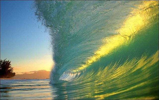
High Surf Advisory…south shores – be careful!
Variable winds, showers active at times locally…
some will be quite generous
The following numbers represent the most recent top wind gusts (mph), along with directions as of early Saturday evening:
24 Lihue, Kauai – NE
24 Kahuku Trng, Oahu – NNE
17 Molokai – NE
20 Kahoolawe – ENE
15 Lipoa, Maui – NE
24 Upolu airport, Big Island – NE
Here are the latest 24-hour precipitation totals (inches) for each of the islands as of Saturday evening:
0.31 Kilohana, Kauai
1.18 Poamoho RG 1, Oahu
1.04 Molokai
0.00 Kahoolawe
1.36 Puu Kukui, Maui
2.94 Pohakuloa Keamuku, Big Island
We can use the following links to see what’s going on in our area of the north central Pacific Ocean. Here’s the latest NOAA satellite picture – the latest looping satellite image… and finally the latest looping radar image for the Hawaiian Islands.
~~~ Hawaii Weather Narrative ~~~
Our local winds will be generally rather light and variable…into the new week. Here’s a weather chart showing high pressure centers far to the northeast and northwest. At the same time, we find a low pressure system to the northeast, with a cold front draped south and southeast…to the north of the state. Finally, more locally, there’s a trough of low pressure over Maui at the time of this writing. The winds will be quite light and variable…although locally stronger in places. It will take until later in the new week ahead, before the trade winds return, and a more normal late spring weather pattern settles in over us again, perhaps as long as later Thursday or Friday.
Satellite imagery shows a large arc of low clouds around the islands, with higher level cirrus over the ocean to the south. Here’s the looping radar image, showing numerous showers…especially offshore to the southeast of the Big Island at the time of this writing. As mentioned in the paragraph above, the trough of low pressure now over the islands, will keep unstable conditions over us, prompting showers at times. The presence of this trough will enhance any showers that fall, wherever that happens to be this weekend…especially during the afternoon to early hours. Here’s a looping satellite image – showing the precipitation characteristics over the islands. Yellow and red are higher clouds, and where the heaviest showers can be located, while whiter and greener clouds are lower, and typically less rainfall producers in most cases. It appears that this off and on cloudy/showery weather pattern will last into the middle of the new work week ahead.
The current unsettled weather pattern is unique for this time of year…and is rather difficult to read the particulars. Typically, we’d find the trade winds blowing in May, with generally dry weather, other than a few windward biased showers. This is not the case now however, as we have low pressure aloft, and at the surface…over the island area this weekend. This is causing our winds to become lighter, from variable directions. Vog will be carried up over Maui County, as the winds are blowing emissions up from the Big Island vents now. The overlying atmosphere is becoming more unstable, caused by all this low pressure around now. This simply means that any showers that fall, and there will be some, will tend to be more generous than usual into the new week. I expect these showers to be of the hit and miss nature by the way, rather than a widespread rainfall event. I’ll be back with more updates on this unusual weather situation, I hope you have a great Saturday night wherever you’re spending it. Aloha for now…Glenn.
A couple of Saturday night youtube music videos by Coldplay, called Yellow – in full screen view please / and another version of this same song
Friday evening film: Last evening I went to see the film The Great Gatsby, starring Leonardo DiCaprio, Carey Mulligan, Joel Edgerton, Tobey Maguire, Isla Fisher, and Elizabeth Debicki…among others of course. The synopsis: “The Great Gatsby” follows Fitzgerald-like, would-be writer Nick Carraway (Tobey Maguire) as he leaves the Midwest and comes to New York City in the spring of 1922, an era of loosening morals, glittering jazz, bootleg kings, and sky-rocketing stocks. Chasing his own American Dream, Nick lands next door to a mysterious, party-giving millionaire, Jay Gatsby (Leonardo DiCaprio), and across the bay from his cousin, Daisy (Carey Mulligan), and her philandering, blue-blooded husband, Tom Buchanan (Joel Edgerton). It is thus that Nick is drawn into the captivating world of the super rich, their illusions, loves and deceits. As Nick bears witness, within and without of the world he inhabits, he pens a tale of impossible love, incorruptible dreams and high-octane tragedy, and holds a mirror to our own modern times and struggles. ~~~ This film was full of fine detail, and yet with an overarching bigness to it as well. A couple of times I asked myself if I was enjoying it, and the answer was always yes, although at the same time…I felt a non-engagement at times too. I was glad I saw it, and as for a grade, I feel comfortable throwing out a soft B+. I didn’t read the novel, so I have no idea about where this film would be going, or if it stuck close enough to the original story line. It certainly portrayed the glitz and dazzle of the party times that were famous way back then. I saw the 2D version, as I’m almost always disappointed with the 3D films I see. Here’s the trailer, take a look if you’re inclined.
World-wide tropical cyclone activity:
Atlantic Ocean/Caribbean Sea: There are no active tropical cyclones / Here’s a link to the National Hurricane Center in Miami…which covers tropical cyclone activity in the Atlantic, Caribbean Sea…and the Gulf of Mexico. The hurricane season in the Atlantic, Caribbean, and the Gulf of Mexico all begin as of June 1.
Gulf of Mexico: There are no active tropical cyclones
Eastern Pacific Ocean: There are no active tropical cyclones / AN AREA OF LOW PRESSURE…ASSOCIATED WITH THE REMNANTS OF ALVIN…IS LOCATED ABOUT 900 MILES SOUTHWEST OF THE SOUTHERN TIP OF BAJA CALIFORNIA MEXICO. SHOWERS AND THUNDERSTORMS REMAIN DISORGANIZED… AND ANY DEVELOPMENT OF THIS LOW IS EXPECTED TO BE LIMITED DUE TO UPPER-LEVEL WINDS BECOMING INCREASINGLY UNFAVORABLE DURING THE NEXT 24 HOURS. THIS SYSTEM HAS A MEDIUM CHANCE…30 PERCENT…OF BECOMING A TROPICAL CYCLONE AGAIN DURING THE NEXT 48 HOURS AS IT MOVES GENERALLY WESTWARD AT 10 TO 15 MPH.
Here’s a satellite image showing this area.
ELSEWHERE…TROPICAL CYCLONE FORMATION IS NOT EXPECTED DURING THE NEXT 48 HOURS.
Here’s a wide satellite image that covers the entire area between Mexico, out through the central Pacific…to the International Dateline.
Central Pacific Ocean: There are no active tropical cyclones / Here’s a link to the Central Pacific Hurricane Center (CPHC)…covering our central Pacific. The hurricane season in this part of the Pacific begins as of June 1st.
Western Pacific Ocean: There are no active tropical cyclones / Here’s a link to the Joint Typhoon Warning Center (JTWC), which covers tropical cyclone activity in the western Pacific, and the North and South Indian Ocean…and adjacent Seas.
South Pacific Ocean: There are no active tropical cyclones
North and South Indian Oceans: There are no active tropical cyclones
Sigrid Graf Says:
Hi Glen,
thank for that wonderful photo, you published today. I am living in Switzerland and keep looking in your webpage ever so often, to stay in contact with Maui till we can come again…
Kind regards Sigrid~~~
Hi Sigrid, you live so far away…in Switzerland! Sounds like you love Maui, just like the rest of us! I’m pleased that my website brings you pleasure, until you can come back and visit. Be well, Aloha, Glenn