


Air Temperatures – The following maximum temperatures were recorded across the state of Hawaii Friday afternoon:
Lihue, Kauai – 77
Honolulu airport, Oahu – 78
Molokai airport – 74
Kahului airport, Maui – 75
Kona airport – 82
Hilo airport, Hawaii – 77
Air Temperatures ranged between these warmest and coolest spots near sea level – and on the highest mountain tops around the state…as of 630am Saturday morning:
Lihue, Kauai – 73
Kapalua, Maui – 68
Haleakala Summit – M (near 10,000 feet on Maui)
Mauna Loa Summit – 32 (near 13,800 feet on the Big Island)
Hawaii’s Mountains – Here’s a link to the live web cam on the summit of near 13,800 foot Mauna Kea on the Big Island of Hawaii. This web cam is available during the daylight hours here in the islands…and when there’s a big moon shining down during the night at times. Plus, during the nights you will be able to see stars, and the sunrise and sunset too…depending upon weather conditions. Here's the Haleakala Crater webcam on Maui…if it's available.
Tropical Cyclone activity in the eastern and central Pacific – Here’s the latest weather information coming out of the National Hurricane Center, covering the eastern north Pacific. You can find the latest tropical cyclone information for the central north Pacific (where Hawaii is located) by clicking on this link to the Central Pacific Hurricane Center. A satellite image, which shows the entire ocean area between Hawaii and the Mexican coast…can be found here. The 2012 hurricane season is over in the eastern and central Pacific…resuming on May 15th and June 1st 2013.
Aloha Paragraphs
Our winds will be from the trade wind direction…
remaining strong to very strong into the weekend –
then gradually easing up starting Monday onwards
Partly to mostly cloudy, with some clear periods,
showers, especially windward sections, although
elsewhere at times too…remaining relatively cool
Small Craft Advisory for strong and gusty winds…
producing hazardous seas – all marine zones
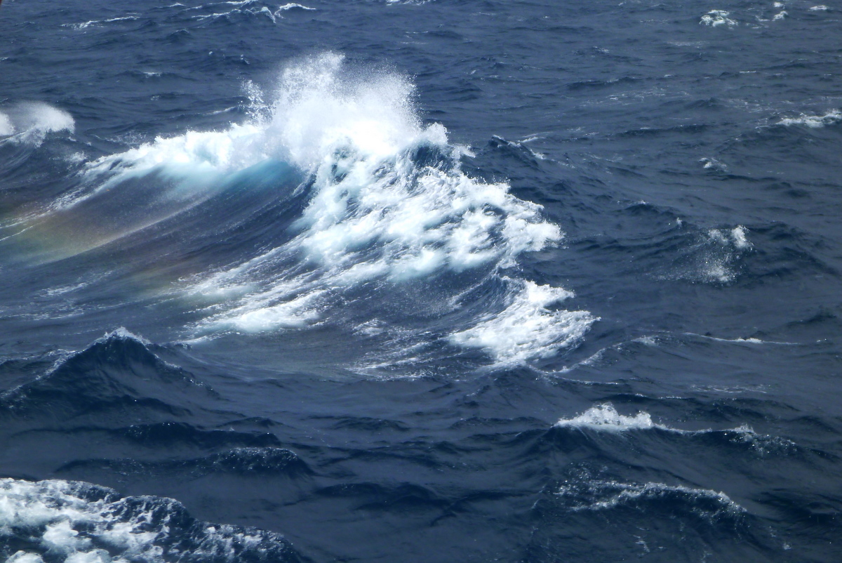
High Surf Advisory…rough and choppy waves
on the east shores
Gale Warning for strong winds…Pailolo /Alenuihaha
Channels, and waters south of the Big Island –
which means 40-52 mph winds
High Wind Warning for the Haleakala summit, Maui…
which means 40-50 mph winds, with gusts to 65 –
this morning through Saturday afternoon
Wind Advisory for all Hawaiian Islands…from 10am
through 6am Saturday morning – which means east
winds 20-35 mph, localized over 50 mph at times
Flood Advisory over windward east Maui…including
the eastern slopes of Haleakala, Pauwela, Paia, Keanae,
Huelo, Hookipa Beach Park, Haliimaile and Haiku
~~~Air temperature at 640m HST Saturday morning, with
clear to partly cloudy skies, light breezes…at my upcountry
Kula, Maui weather tower: 55.2F degrees~~~
The following numbers represent the most recent top wind gusts (mph), along with directions as of Friday night:
33 Lihue, Kauai – NE
42 Kahuku Trng, Oahu – NE
43 Molokai – NE
50 Kahoolawe – NE
40 Lipoa, Maui – SE
M Lanai
54 Kawaihae, Big Island – NE
Here are the latest 24-hour precipitation totals (inches) for each of the islands as of Friday evening:
1.89 Mount Waialeale, Kauai
0.79 Waiawa, Oahu
0.47 Molokai
0.07 Kahoolawe
8.80 Puu Kukui, Maui
0.97 Saddle Quarry, Big Island
We can use the following links to see what’s going on in our area of the north central Pacific Ocean. Here's the latest NOAA satellite picture – the latest looping satellite image…and finally the latest looping radar image for the Hawaiian Islands.
~~~ Hawaii Weather Commentary ~~~
Our winds will remain active from the trade wind direction…remaining strong to very strong into the weekend. Here's a weather chart showing high pressure centers to our northeast through north. At the same time, we find a slowly dissipating frontal boundary over the central islands. The trade winds will remain well established through the rest of this first weekend of 2013. Tonight (at around 1105pm) we found a 40-50+ mph gusts being recorded on Oahu, Kahoolawe, Maui, and the Big Island, ranging between 40-54 mph at the time of this writing.
There will continue to be periods of clouds…with showers locally. Here's a satellite image, showing partly to mostly cloudy skies this evening…with a few clear patches locally. There were high cirrus clouds moving away to the east of the Big Island. A new area of high cirrus is moving by to the north and northeast of the islands as well…getting down into the state locally. In addition, we have an old cold front that's stalled and weakening over the central islands, most notably from Maui County down towards the Big Island. Here's a larger satellite view of all the clouds that are located over the islands, and in all directions…out over the ocean.
These blustery trade winds will keep the remnant cold front's moisture over parts of the state, as off and on passing showers along our windward sides. As the winds become stronger, some of these windward biased showers, will be carried over into the leeward sides on the smaller islands. The most generous precipitation has fallen over Maui County up to Oahu and Kauai during the last 24 hours. The most significant precipitation amount thus far, has been the impressive 8.80" total in the West Maui Mountains…in the Puu Kukui gauge!
We have an unusual array of wind related warnings and advisories active across the Hawaiian Islands now! As such, we have small craft wind advisory flags up over all of our marine environment…from Kauai right down to the Big Island. We have a gale warning issued for the Pailolo (between Molokai and Maui) and Alenuihaha Channels (between Maui and the Big Island), and the area south of the Big Island. We also have wind advisories going up over all of the islands themselves as well. The Haleakala Summit area on east Maui has a high wind warning in effect too. To have a few of these active isn't terribly unusual, although to have all of them going off at the same time…is what I would call quite rare!
This is a time to batten down the hatches, that is if you live in one of our wind prone areas…where the trade winds are typically strong and gusty. Winds will be gusting up into the 40-50+ mph range over the next two days, making for very rough and choppy ocean conditions into the weekend. I would think twice or three times, before going out into the offshore waters over the next several days, unless that is…you're with an experienced captain who knows the ropes. I'd also secure your trash barrels, and lawn furniture, those kinds of things, that can be pushed around, under the influence of these stronger than usual gusty trade winds. I'll be back Saturday morning with more news on this windy episode, I hope you have a great Friday night wherever you're spending it! Aloha for now…Glenn.
Notice: Many of you regular readers know that I add youtube music videos here sometimes. It's fun to share them with you, I enjoy it. At any rate, as part of a few new things in 2013…I'd like to invite you to submit a music video yourself. I'll post it here, along with your name and where you live (please include that). Does that sound like fun? Who doesn't like music, and sharing a favorite song! So, send me one, or let me know one of your favorite ones, and I'll try to find it on youtube.com. Use the comment box on the bottom of this page, or email me using the address down there too. Here's our first one!
Bob Earle, Placerville, California…Carrie Rodrigues – Big Love / full screen please
Or something like this…which is very cool! – full screen please
Friday night film: This week there are so many new, and great looking films that have hit the theaters. My neighbors Jeff and Svetlana, some friends Jill and Clive, and another lady Cindy and I, will be heading down to Kahului for dinner and a film. This week its the new one called Django Unchained, directed by Quentin Tarantino, and starring Jamie Foxx, Christoph Waltz, Samuel L. Jackson, Leonardo DiCaprio, Kurt Russell, Laura Cayouette, Don Johnson, Misty Upham, Catherine Lambert…among many others.
The synopsis: Django is a slave whose brutal history with his former owners lands him face-to-face with German-born bounty hunter Dr. King Schultz. Schultz is on the trail of the murderous Brittle brothers, and only Django can lead him to his bounty. The unorthodox Schultz acquires Django with a promise to free him upon the capture of the Brittles — dead or alive. Success leads Schultz to free Django, though the two men choose not to go their separate ways. Instead, Schultz seeks out the South's most wanted criminals with Django by his side. Honing vital hunting skills, Django remains focused on one goal: finding and rescuing Broomhilda, the wife he lost to the slave trade long ago. Django and Schultz's search ultimately leads them to Calvin Candie, the proprietor of "Candyland," an infamous plantation. Exploring the compound under false pretenses, Django and Schultz arouse the suspicion of Stephen, Candie's trusted house slave. Their moves are marked, and a treacherous organization closes in on them. If Django and Schultz are to escape with Broomhilda, they must choose between independence and solidarity, between sacrifice and survival.
If you know Quentin Tarrantino films, they are anything but gentle! This film is being given an R rating, for strong language, graphic violence throughout, vicious fighting, and some nudity. This is not for the faint of heart, and I'm already wondering if I'll have to avert my eyes, or perhaps…how many times that will happen. I already know that I won't be able to recommend this 2 hour and 45 minute film, far from it in fact. Nonetheless, it has been given high rankings by the critics, so I'm game. I'll give you my impression Saturday morning, and until then, if you dare, here's the trailer for Django Unchained.
Interesting facts: A fully loaded supertanker traveling at normal speed takes a least twenty minutes to stop / Every person has a unique tongue print / Fingernails grow nearly 4 times faster than toenails / During your lifetime, you'll eat about 60,000 pounds of food, that's the weight of about 6 elephants
World-wide tropical cyclone activity:
Atlantic Ocean/Caribbean Sea: There are no active tropical cyclones
Gulf of Mexico: There are no active tropical cyclones
Eastern Pacific Ocean: There are no active tropical cyclones
Central Pacific Ocean: There are no active tropical cyclones
Western Pacific Ocean: Tropical cyclone 01W (Sonamu) remains active…located approximately 300 NM southeast of Ho Chi Minh City, Vietnam. Sustained winds were 45 knots, with gusts to near 55 knots. This tropical storm will increase in strength a bit more, and then steadily decrease…as it moves across the South China Sea. Here's the JTWC graphical track map, along with a satellite image.
South Pacific Ocean: There are no active tropical cyclones
North and South Indian Oceans: Tropical cyclone 07S (Dumile) is dissipating in the south Indian Ocean…located approximately 600 NM south-southeast of La Reunion Island. Sustained winds were 50 knots, with gusts to near 65 knots. This tropical cyclone will decrease in strength and dissipate, as it continues to move over the open ocean. Here's the JTWC graphical track map, along with a satellite image. – Final Warning
Suzie Says:
Hi Glenn, the weather has been great in Kihei, hot sunny, and yesterday not much wind. Just wanted to let any visitors know that are in the rain in East or West Maui, that the South Shore has been beautiful. Thanks and enjoy your weekend! ~~~Hi Suzie, thanks for the report, that is very helpful! The winds have so much east in them, that the Kihei/Wailea area is in the lee of the Haleakala Crater. Up there in Kula too, its been very light winds, although with misty showers at times. Hot and sunny and not much wind, sounds glorious! Aloha, Glenn
Rosemary Says:
FYI… Extremely heavy rain and winds out here for at least 30 hours straight. Haiku near mile marker 14. Hard to believe it's going to continue through the weekend. ~~~Hi Rosemary, I agree, its a long period of winterized blustery weather there on the windward side of east Maui! Hang on through this weekend, as there is relief on the horizon…after the weekend. Thanks for your report, Aloha, Glenn