


March 25-26, 2009
Air Temperatures – The following maximum temperatures were recorded across the state of Hawaii Wednesday afternoon:
Lihue, Kauai – 76
Honolulu, Oahu – 82
Kaneohe, Oahu – 76
Kahului, Maui – 82
Hilo, Hawaii – 75
Kailua-kona – 80
Air Temperatures ranged between these warmest and coolest spots near sea level – and on the highest mountains…at 5 p.m. Wednesday evening:
Port Allen, Kauai – 79F
Hilo, Hawaii – 70
Haleakala Crater – missing (near 10,000 feet on Maui)
Mauna Kea summit – 32 (near 14,000 feet on the Big Island)
Precipitation Totals – The following numbers represent the largest precipitation totals (inches) during the last 24 hours on each of the major islands, as of Wednesday afternoon:
0.81 Mount Waialaele, Kauai
0.26 Nuuanu Upper, Oahu
0.01 Molokai
0.00 Lanai
0.00 Kahoolawe
0.49 West Wailuaiki, Maui
0.33 Glenwood, Big Island
Weather Chart – Here’s the latest (automatically updated) weather map showing a strong 1040 millibar high pressure system far to the northeast of the islands. Our trade winds will be moderate to locally strong and gusty Wednesday night and Thursday…lighter in those more protected places.
Satellite and Radar Images: To view the cloud conditions we have here in Hawaii, please use the following satellite links, starting off with the Infrared Satellite Image of the islands to see all the clouds around the state during the day and night. This next image is one that gives close images of the islands only during the daytime hours, and is referred to as a Close-up visible image. This next image shows a larger view of the Pacific…giving perspective to the wider ranging cloud patterns in the Pacific Ocean. Finally, here’s a looping IR satellite image, making viewable the clouds around the islands 24 hours a day. To help you keep track of where any showers may be around the islands, here’s the latest animated radar image.
Hawaii’s Mountains – Here’s a link to the live webcam on the summit of near 14,000 foot Mauna Kea on the Big Island of Hawaii. The tallest peak on the island of Maui is the Haleakala Crater, which is near 10,000 feet in elevation. These two webcams are available during the daylight hours here in the islands…and when there’s a big moon rising just after sunset for an hour or two! Plus, during the nights and early mornings you will be able to see stars, and the sunrise too…depending upon weather conditions.
Aloha Paragraphs
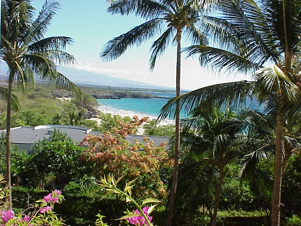
Big Island beauty!
Photo Credit: Google.com
The locally gusty trade winds will continue to blow, although at the same time…providing generally good weather. A strong 1040 millibar high pressure system is the source of these strong and gusty winds Wednesday night. These winds are strong enough to keep small craft wind advisories active across most of the Hawaiian coastal and channel waters, from Kauai down through the Big Island. Those areas that are more protected from the trade winds will have lighter winds as usual. The high surf advisory remains active in response to the large waves generated by these gusty trade winds…along the east facing windward shores.
The local atmosphere is generally quite dry, although with the trade winds this strong…there will be a few windward biased showers. Looking at this satellite image, shows the next wave of high cirrus clouds looming to the west of the islands. The leading edge of this icy moisture looks pretty thin, although could become a bit thicker during the day Thursday. This larger view shows the extent of this cirrus. At lower levels of the atmosphere, we see some moisture pockets being carried in our direction, although nothing organized is taking aim on our islands at this time.
The speedy winds will continue to be the most remarkable weather feature here in the islands, although interestingly enough, it won’t be windy everywhere. The direction of our trade winds continues to show an ever so slight veering to the south of east. The trade winds typically blow from the east-northeast to east. This ESE direction puts some areas of the state in the wind shadow of the larger mountains…especially on Maui and the Big Island. Case in point: Kihei and Kula, Maui, have both had generally light winds the last several days, even though some areas on Maui have experienced 40+ mph gusts. It just depends upon the exposure to these ESE winds, and how different areas are oriented to the wind flow.
I’m about ready to leave Kihei, for the drive over to Kahului. This evening I’m going to see a film at the Maui Arts and Cultural Center, since Thursday is a holiday here in the islands. This film is called Owl and the Sparrow (2007). The story happens in modern day Saigon, with three lonely strangers forming a unique family, as a ten-year old orphan plays matchmaker to a zookeeper, and a beautiful flight attendant. Apparently this is a moving film, which won the Audience Award at the 2008 Los Angeles Film Festival. It is in Vietnamese, with English subtitles. I’m in the mood for a charming film such as this, and will give you my impression Thursday morning. Here’s a trailer for the film, which looks good to me. I trust that you will have a great Wednesday night, along with an invitation to join me here again soon! Aloha for now…Glenn.
Interesting: Fish caught near wastewater treatment plants serving five major U.S. cities had residues of pharmaceuticals in them, including medicines used to treat high cholesterol, allergies, high blood pressure, bipolar disorder and depression, researchers reported Wednesday. Findings from this first nationwide study of human drugs in fish tissue have prompted the Environmental Protection Agency to significantly expand similar ongoing research to more than 150 different locations.
"The average person hopefully will see this type of a study and see the importance of us thinking about water that we use every day, where does it come from, where does it go to? We need to understand this is a limited resource and we need to learn a lot more about our impacts on it," said study co-author Bryan Brooks, a Baylor University researcher and professor who has published more than a dozen studies related to pharmaceuticals in the environment.
A person would have to eat hundreds of thousands of fish dinners to get even a single therapeutic dose, Brooks said. But researchers including Brooks have found that even extremely diluted concentrations of pharmaceutical residues can harm fish, frogs and other aquatic species because of their constant exposure to contaminated water.
Interesting2: A newly laid, 32-mile underwater cable finally links the state’s only seafloor seismic station with the University of California, Berkeley’s seismic network, merging real-time data from west of the San Andreas fault with data from 31 other land stations sprinkled around Northern and Central California. Laying of the MARS (Monterey Accelerated Research System) fiber-optic cable was completed in 2007 by the Monterey Bay Aquarium Research Institute (MBARI) to power and collect data from a cluster of scientific instruments nearly 3,000 feet below the surface of Monterey Bay, 23 miles from the coastal town of Moss Landing.
A broadband seismometer that had been placed on the seafloor in 2002 was connected to the cable on Feb. 27, 2009, obviating the need to send a remotely operated vehicle (ROV) every three months to replace the battery and collect data. "Before, we had to wait three months to even know if the instruments were alive," said Barbara Romanowicz, director of the Berkeley Seismological Laboratory and a UC Berkeley professor of earth and planetary science.
Now, she said, "we can use the data from the seafloor station in real time together with those from the rest of the Berkeley Digital Seismic Network" to determine the location, magnitude and mechanism of offshore earthquakes, learn about the crust at the edge of the continental plate and understand better the hazards of the San Andreas fault system that runs north and south through the state.
According to Romanowicz, earthquake monitoring systems around the world have been trying to place seismometers on the seafloor for decades to cover the 71 percent of the Earth’s surface that is beneath the oceans. Islands have generally provided the only offshore data – the Berkeley network has one seismic station on the Farallon Islands – but these provide only spotty coverage.
Because the state’s main fault system, the San Andreas, runs along the Northern California coast, seafloor monitors are particularly critical. All but one station – the Farallon station – are east of the fault, making it hard to gain a comprehensive view of the fault system.
Interesting3: A brilliant green tree frog with huge black eyes, jumping spiders and a striped gecko are among more than 50 new animal species scientists have discovered in a remote, mountainous region of Papua New Guinea. The discoveries were announced Wednesday by Washington D.C.-based Conservation International, which spent the past several months analyzing more than 600 animal species the group found during its expedition to the South Pacific island nation in July and August.
Of the animals discovered, 50 spider species, three frogs and a gecko appear to have never been described in scientific literature before, the conservation group said. The new frogs include a tiny brown animal with a sharp chirp, a bug-eyed bright green tree frog and another frog with a loud ringing call. One of the jumping spiders is shiny and pale green, while another is furry and brown.
In a sharp reversal of Bush administration policies, the head of the Environmental Protection Agency said Tuesday that the agency planned an aggressive review of permit requests for mountaintop coal mining, citing serious concerns about potential harm to water quality.
The administrator, Lisa P. Jackson, said her agency had sent two letters to the Army Corps of Engineers on Monday in which it expressed concern about two proposed mining operations in West Virginia and Kentucky involving mountaintop removal, a form of strip mining that blasts the tops off mountains and dumps leftover rock in valleys, burying streams.
Interesting4: Red jasper cored from layers 3.46 billion years old suggests that not only did the oceans contain abundant oxygen then, but that the atmosphere was as oxygen rich as it is today, according to geologists. This jasper or hematite-rich chert formed in ways similar to the way this rock forms around hydrothermal vents in the deep oceans today. "Many people have assumed that the hematite in ancient rocks formed by the oxidation of siderite in the modern atmosphere," said Hiroshi Ohmoto, professor of geochemistry, Penn State.
"That is why we wanted to drill deeper, below the water table and recover un-weathered rocks." The researchers drilled diagonally into the base of a hill in the Pilbara Craton in northwest Western Australia to obtain samples of jasper that could not have been exposed to the atmosphere or water. These jaspers could be dated to 3.46 billion years ago. "Everyone agrees that this jasper is 3.46 billion years old," said Ohmoto.
"If hematite were formed by the oxidation of siderite at any time, the hematite would be found on the outside of the siderite, but it is found inside," he reported in a recent issue of Nature Geoscience. Interesting5: Maize was domesticated from its wild ancestor more than 8700 years according to biological evidence uncovered by researchers in the Mexico’s Central Balsas River Valley.
Interesting5: This is the earliest dated evidence — by 1200 years — for the presence and use of domesticated maize. According to Ranere, recent studies have confirmed that maize derived from teosinte, a large wild grass that has five species growing in Mexico, Guatemala and Nicaragua. The teosinte species that is closest to maize is Balsas teosinte, which is native to Mexico’s Central Balsas River Valley.
"We went to the area where the closest relative to maize grows, looked for the earliest maize and found it," said Ranere. "That wasn’t surprising since molecular biologists had determined that Balsas teosinte was the ancestral species to maize. So it made sense that this was where we would find the earliest domestication of maize."
The study began with Piperno, a Temple University anthropology alumna, finding evidence in the form of pollen and charcoal in lake sediments that forests were being cut down and burned in the Central Balsas River Valley to create agricultural plots by 7000 years ago. She also found maize and squash phytoliths — rigid microscopic bodies found in many plants — in lakeside sediments. Ranere, an archaeologist, joined in the study to find rock shelters or caves where people lived in that region thousands of years ago.
His team carried out excavations in four of the 15 caves and rock shelters visited in the region, but only one of them yielded evidence for the early domestication of maize and squash. Ranere excavated the site and recovered numerous grinding tools. Radiocarbon dating showed that the tools dated back at least 8700 years.
Although grinding tools were found beneath the 8700 year level, the researchers were not able to obtain a radiocarbon date for the earliest deposits. Previously, the earliest evidence for the cultivation of maize came from Ranere and Piperno’s earlier research in Panama where maize starch and phytoliths dated back 7600 years.
Interesting6: She may have ruled like a man, but Egyptian queen Hatshepsut still preferred to smell like a lady. The world may be able to get a whiff of that ancient royal scent when researchers complete their investigation into the perfume worn by Hatshepsut, the powerful pharaoh-queen who ruled over ancient Egypt for 20 years beginning around 1479 B.C. Analyzing a metal jar belonging to the famous queen , the team from the Bonn University Egyptian Museum in Germany recently found residue thought to be leftovers from Hatshepsut’s own perfume.
Their next step will be attempting to "reconstruct" the scent, which was likely made from pricey incense imported from present-day Somalia. Though funerary objects belonging to Egypt’s ancient rulers fill museums around the world, if successful, this will be the first time that a pharaoh’s perfume is recreated, the researchers said. Hatshepsut stepped in as one of ancient Egypt’s rare female leaders when her half-brother and husband, Pharaoh Thutmose II, died without an adult male heir.
She was meant to rule as a co-regent only until her stepson Thutmose III matured, but she effectively took the reins and was recognized as the pharaoh by the royal court and religious officials until her death in 1457 B.C., Egyptologists say. Despite her gender, Hatshepsut’s two decades as pharaoh are considered an incredibly successful time. Ruling like a man, historians say, she mounted at least one military campaign but kept Egypt largely peaceful, and commissioned several impressive building projects.
Hatshepsut is best known, perhaps, for reopening southern trade routes that had been interrupted by war, increasing the wealth of her empire. She famously launched a naval caravan to the ancient land of Punt — what today is called the Horn of Africa — bringing back ships laden with myrrh, frankincense and, notably, incense plants which were then replanted near her funerary temple (commonly under construction well before a pharaoh’s death), according to ancient documents.
"Incense was extremely valuable in ancient Egypt and was used only in temples and for living gods (such as the king)," said Michael Höveler-Müller, curator of the Bonn University Egyptian Museum. It is this incense that researchers suspect they have found in a filigree container bearing the queen’s name. Using powerful X-rays, the remains of a dried-out fluid were discovered at the bottom of the flacon. Pharmacologists will now analyze the residue and break it into its constituents, in the hopes of putting the scent back together, 3,500 years after Hatshepsut last wore it.