


September 8-9 2008
Air Temperatures – The following maximum temperatures were recorded across the state of Hawaii Monday afternoon:
Lihue, Kauai – 85
Honolulu, Oahu – 87
Kaneohe, Oahu – 85
Kahului, Maui – 88
Hilo, Hawaii – 84
Kailua-kona – 84
Air Temperatures ranged between these warmest and coolest spots near sea level, and on the taller mountains…at 4 p.m. Monday afternoon:
Port Allen, Kauai -90F
Kaneohe, Oahu – 80
Haleakala Crater- 46 (near 10,000 feet on Maui)
Mauna Kea summit – 45 (near 14,000 feet on the Big Island)
Precipitation Totals – The following numbers represent the largest precipitation totals (inches) during the last 24 hours on each of the major islands, as of Monday afternoon:
0.35 Wailua, Kauai
0.06 Dillingham, Oahu
0.01 Molokai
0.00 Lanai
0.01 Kahoolawe
0.32 Oheo Gulch, Maui
0.54 Mountain View, Big Island
Weather Chart – Here’s the latest (automatically updated) weather map showing a 1030 millibar high pressure system located far to the northeast of Hawaii…with its associated ridge now weakening to our north. This pressure configuration will prompt our local trade winds to be lighter Tuesday and Wednesday, although still locally gusty.
Satellite and Radar Images: To view the cloud conditions we have here in Hawaii, please use the following satellite links, starting off with the Infrared Satellite Image of the islands to see all the clouds around the state during the day and night. This next image is one that gives close images of the islands only during the daytime hours, and is referred to as a Close-up visible image. This next image shows a larger view of the Pacific…giving perspective to the wider ranging cloud patterns in the
Aloha Paragraphs
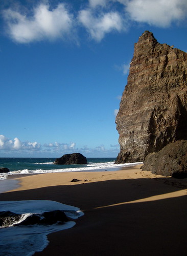
Remote north shore beach on Kauai
Photo Credit: flickr.com
Our light to locally moderate trade wind flow will continue for the time being…although getting lighter soon through the rest of this week. The trade winds won’t go away completely, but just become lighter by mid-week. There will be daytime sea breezes in those areas that are more sheltered from the trade winds. The reason our local trade winds will be losing some strength, is due to the weakening of our high pressure ridge to the north of the islands. The forecast models show no significant increase in our local trade winds through the next week.
There will be a few showers, although generally on the light side, falling along the windward sides…and in the leeward areas at times during the afternoons too. The overlying atmosphere remains stable enough, that whatever showers that do manage to fall, will remain rather insignificant. There are still no organized rainmakers on the weather horizon at this time…suggesting fair weather will prevail well into the future.
There are several menacing tropical cyclones churning the world’s tropical oceans now. Foremost among those is dangerous hurricane Ike, which is giving a beating to Cuba. Ike, which is a strong hurricane, is on its way into the Gulf of Mexico. Here’s the tracking map for Ike, which is a very dangerous storm. By the way, here’s the way the hurricane models are handling Ike as it takes aim on somewhere along the Gulf coast. Then we have tropical storm Lowell in the eastern Pacific, which is heading towards the southern Baja coast…here’s a tracking map. Then in the western Pacific Ocean, we find tropical storm Sinlaku in the Philippine Sea as well, which will move by Luzon Island, offshore to the east…with a tracking map.
It’s early Monday evening here in Kihei, Maui, as I begin writing this last paragraph of today’s tropical weather narrative from Hawaii. Monday was yet another of these near perfect, late summer days…that are often found during the month of September. There was hardly any precipitation, and there was enough of a trade wind flow, that air temperatures felt very warm but not necessarily hot. The leeward beaches were the warmest areas, as usual. The trade winds remained active Monday afternoon, with the top gust at 33 mph (5pm), at those blustery Maalaea Bay on Maui. I see no reason to believe that anything other than more nice weather will prevail through the end of this week, and likely right on into the early part of next week. I’ll be back very early Tuesday morning with your next new weather narrative from paradise. I hope you have a great Monday night until then! Aloha for now…Glenn.
Interesting:
The world must speed up the deployment of solar power as it has the potential to meet all the world’s energy needs, the chairman of an industry gathering which wrapped up Friday in Spain said. "The solar energy resource is enormous, and distributed all over the world, in all countries and also oceans," said Daniel Lincot, the chairman of the five-day European Photovoltaic Solar Energy conference held in
Last year the world production of photovoltaic models represented a surface of 40 square kilometres (16 square miles) while meeting the electrical consumption of countries like
Interesting2:
A new set of United Nations laws may be needed to regulate new Arctic industries such as shipping and oil exploration as climate change melts the ice around the North Pole, legal experts said on Sunday. They said existing laws governing everything from fish stocks to bio-prospecting by pharmaceutical companies were inadequate for the polar regions, especially the
Dozens of legal experts are meeting in
Interesting3: Wide rivers of ice, called ice streams, flow through relatively slow-moving polar ice sheets, en route to the sea. Glaciologists had assumed that ice streams just creep steadily along—until one was recently shown to pack a powerful one-two punch, generating seismic waves twice a day. The seismic signals from
Interesting4:
The U.S. bottled water market is slowing down after years of steady growth, suggesting that international awareness campaigns may be curbing consumer demand. While bottled water continues to expand in global popularity, the
Bottled water sold in most industrialized countries costs between $500 and $1,000 per cubic meter, compared to $0.50 for municipal water in states such as
Interesting5:
Valleys on Mars were carved over long periods by recurring floods at a time when Mars might have had wet and dry seasons much like some of Earth’s deserts, a new study suggests. The research contradicts other suggestions that the large valley networks on the red planet were the result of short-lived catastrophic flooding, lasting just hundreds to a few thousand years and perhaps triggered by asteroid impacts. The new modeling suggests wet periods lasted at least 10,000 years. "Precipitation on Mars lasted a long time – it wasn’t a brief interval of massive deluges," said study leader Charles Barnhart, a graduate student in Earth and planetary sciences at the
NASA planetary scientist Jeffrey Moore and Alan Howard of the