


September 6-7 2008
Air Temperatures – The following maximum temperatures were recorded across the state of Hawaii Saturday afternoon:
Lihue, Kauai – 84
Honolulu, Oahu – 88
Kaneohe, Oahu – 84
Kahului, Maui – 88
Hilo, Hawaii – 83
Kailua-kona – 86
Air Temperatures ranged between these warmest and coolest spots near sea level, and on the taller mountains…at 4 p.m. Saturday afternoon:
Kapalua, Maui -86F
Hilo, Hawaii – 76
Haleakala Crater- 52 (near 10,000 feet on Maui)
Mauna Kea summit – missing (near 14,000 feet on the Big Island)
Precipitation Totals – The following numbers represent the largest precipitation totals (inches) during the last 24 hours on each of the major islands, as of Saturday afternoon:
0.42 Mount Waialaele, Kauai
0.26 Nuuanu upper, Oahu
0.01 Molokai
0.00 Lanai
0.09 Kahoolawe
0.36 West Wailuaiki, Maui
0.21 Glenwood, Big Island
Weather Chart – Here’s the latest (automatically updated) weather map showing a 1029 millibar high pressure system located far to the northeast of Hawaii. At the same time we find several low pressure systems, with their associated cold front, pushing the high pressure cell’s ridge down closer to our islands. This pressure configuration will prompt our local trade winds to be somewhat lighter Saturday…then picking up some Sunday.
Satellite and Radar Images: To view the cloud conditions we have here in Hawaii, please use the following satellite links, starting off with the Infrared Satellite Image of the islands to see all the clouds around the state during the day and night. This next image is one that gives close images of the islands only during the daytime hours, and is referred to as a Close-up visible image. This next image shows a larger view of the Pacific…giving perspective to the wider ranging cloud patterns in the
Aloha Paragraphs
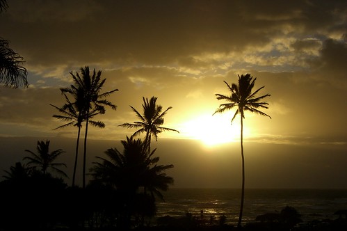
Sunset over Kauai
Photo Credit: flickr.com
The trade winds have slowed down a little, and will likely remain somewhat lighter than normal in the new week ahead. September is a month that usually has the trade winds blowing, as our high pressure system, the source of our local trade winds, remains in it’s more or less late summertime position…northeast of here. This weather map, shows a high pressure system, now weighing-in at 1029 millibars, located far to the northeast…still offshore from the
In terms of precipitation, there shouldn’t be very much, given the dry and stable atmospherics overlying the
A new tropical cyclone named Lowell, has formed recently in the eastern Pacific. We have two tropical systems: Ike, and Hanna in the Atlantic and Caribbean Sea…which is much bigger news. Here’s a graphical map, showing these storms. The first, tropical storm Hanna, is racing up the eastern seaboard, bringing gusty winds and heavy duty rainfall…here’s a tracking map. Then Ike, which is a strong hurricane, will give a powerful blow to Cuba, on its way into the Gulf of Mexico. Here’s the tracking map for Ike, which is a very dangerous storm. By the way, here’s the way the hurricane models are handling Ike as it takes aim on somewhere along the Gulf coast! Josephine has fizzling out over open ocean.
It’s early Saturday evening here in Kula, Maui, as I begin writing this last paragraph of today’s tropical weather narrative from Hawaii. As the information above describes, rather dry weather will prevail, with just light to locally moderate trade winds blowing for the time being. Friday evening after work I went to see the new film called Bangkok Dangerous (2008), starring Nicholas Cage, among others, who I don’t recognize any of their names. A short synopsis of this film, which is getting only average (or less) ratings, is about a cold-blooded hit man who heads to Bangkok to pull off four jobs, and winds up falling in love with a local girl, and bonding with his errand boy. Despite the very dire nature of this film, I ended up liking it quite a bit. There was the killing, quite a bit of that in fact, although somehow it wasn’t all that unsettling. It was full of the action that somehow pulls me in so strongly, along with a story that eventually gave the hit man, Nicholas Cage, a heart after all. Like many of the films that I’m drawn to see, it’s a scary world there, full of things happening that would scare me to death, perhaps that’s why it’s so interesting to see…poking your head into a reality that you’d never want to be in during real life! Here’s a trailer for this film, if you are interested in taking a look. Saturday has been a nice day, although a bit on the hot and humid side around the edges, and especially down near the leeward beaches…where the winds are lightest. I expect Saturday night to remain fair, with more good late summer weather to continue through Sunday. Actually, I still don’t see any inclement weather conditions visiting the Hawaiian Islands well into the future! I hope you have a great Saturday night, I’ll be back Sunday morning with the next new weather narrative from paradise. Aloha for now…Glenn.
Interesting:
Asian pollution from Asian power plants, cooking and heating could create summer hot spots in the central United States and southern Europe by mid-century, U.S. climate scientists reported on Thursday. Unlike the long-lived greenhouse gas carbon dioxide, the particle and gas pollution cited in this report only stays in the air for a few days or weeks but its warming effect on the climate half a world away could last for decades, the scientists said. "We found that these short-lived pollutants have a greater influence on the Earth’s climate throughout the 21st century than previously thought," said Hiram "Chip" Levy of the U.S. National Oceanic and Atmospheric Administration. "By 2050, two of the three climate models we use found that changes in short-lived pollutants will contribute 20 percent of the predicted global warming." By 2100, that figure goes up to 25 percent, Levy said in a telephone briefing. The short-lived pollution that can cause long-term warming comes from soot, also known as the black carbon particles that result from fires, and sulfate particles, which are emitted by power plants. Soot particles are dark and absorb heat; sulfates are light and reflect heat, actually cooling things down.
Asian soot and sulfate pollution is likely to make for hotter, drier summers in the American Midwest and the Mediterranean region of southern Europe, Levy said, adding that heating and drying effects are not expected to hit
Interesting2:
Satellite imagery released earlier this week provided further evidence that deforestation in Brazil’s Amazon region accelerated dramatically this year. Between August 2007 and July 2008, 8,147 square kilometers of the Brazilian Amazon were cleared, according to the country’s National Institute for Space Research (INPE). This is an area more than twice the size of the
As world leaders debate a new international agreement on climate change, preservation of the vast Amazon forest, which stores large amounts of carbon, has been identified as a necessary step to avoid accelerated warming. The Brazilian government has taken additional steps in recent months to curb illegal logging, but a growing global market for beef and soybeans encourages the deforestation. The diverse Amazon forest contains one in ten of the world’s known species and enough vegetation to absorb an estimated 10 percent of atmospheric carbon dioxide, not including oceanic carbon sinks. Since the 1970s, about 20 percent of the Amazon forest has been cut, leaving mainly open fields with little diversity in its place. Illegal deforestation reached its peak this year between August 2007 and April, when satellite images observed about 84 percent of the year’s deforestation.
Interesting3:
The Rosetta deep space probe successfully passed close to an asteroid 250 million miles from Earth, the European Space Agency said Friday night. In a mission that may bring man closer to solving the mystery of the solar system’s birth, the craft completed its flyby of the Steins asteroid, also known as Asteroid 2867 — now in the asteroid belt between the orbits of Mars and Jupiter — at around 3:15 p.m. EDT. As planned, the spacecraft’s signal was lost for about 90 minutes as engineers turned it away from the sun and because the craft was moving too fast for its antennas to transmit. The resumption of the craft’s signal transmission was greeted with cheers from ESA engineers and technicians. "We’re extremely happy that it worked," mission manager Gerhard Schwehm said, sipping a glass of champagne after the announcement from the control room. "It’s a big relief. People can relax a bit now and everything seems fine." Schwehm said the agency would work to get images and other data collected by the probe processed as soon as possible.
He said the first images should be released to the public Saturday. "The operation went very well," Paolo Ferri, the head of the solar and planetary missions division and Rosetta flight operations director, said in a short speech after the announcement. "The spacecraft is in exactly the condition we expected, which is good. All indications are that everything was super successful." The timing of the flyby meant the asteroid was illuminated by the sun, making it likely the transmitted images will be clear and sharp for scientists working on the origins of the solar system. "Dead rocks can say a lot," Schwehm said. Astronomers have had to work with limited data from previous passes of asteroids, such as when ESA’s Giotto probe swept by Halley’s Comet in 1986, photographing long canyons, broad craters and 3,000-foot hills. Steins was Rosetta’s first scientific target as flies in the asteroid belt between the orbits of Mars and Jupiter en route to its main destination, the comet 67/P Churyumov-Gerasimenko, which is scheduled for 2014. The probe was launched in March 2004.
Interesting4:
There’s a mushroom boom in the wet woods of the Northeast this summer. Hillsides bloom with black trumpets. Disc-shaped mushrooms called artist’s conch sprout from tree trunks. Forests are laced with tasty chanterelles giving off faint whiffs of apricot and with a pretty but deadly variety called destroying angels. "For the last two summers we’ve had lousy crops of mushrooms because it was too hot and it was too dry," agroforester Bob Beyfuss said during a recent ramble through a Catskill forest. Not so during this season of soaking rains. Beyfuss found caps sprouting from the forest floor practically behind every tree. Rainfall has been well above average around
Rain is fungus fuel, and it has helped along a bumper crop for mushrooms that is expected to last into the fall foraging season. "It’s been the best summer since 1989," said Russ Cohen, a veteran forager from the