


September 19-20 2008
Air Temperatures – The following maximum temperatures were recorded across the state of Hawaii Friday afternoon:
Lihue, Kauai – 84
Honolulu, Oahu – 86
Kaneohe, Oahu – 82
Kahului, Maui – 88
Hilo, Hawaii – 83
Kailua-kona – 85
Air Temperatures ranged between these warmest and coolest spots near sea level, and on the highest mountains…at 5 p.m. Friday evening:
Kahului, Maui – 84F
Hilo, Hawaii – 77
Haleakala Crater- 54 (near 10,000 feet on Maui)
Mauna Kea summit – 43 (near 14,000 feet on the Big Island)
Precipitation Totals – The following numbers represent the largest precipitation totals (inches) during the last 24 hours on each of the major islands, as of Friday afternoon:
0.15 Lihue airport, Kauai
0.80 Hakipuu Mauka, Oahu
0.07 Molokai
0.00 Lanai
0.00 Kahoolawe
0.46 Oheo Gulch, Maui
0.25 Kahua Ranch, Big Island
Weather Chart – Here’s the latest (automatically updated) weather map showing two fairly weak high pressure systems located to the north, and far to the east-northeast of Hawaii. This pressure configuration will keep trade winds on the light side light side Friday and Saturday.
Satellite and Radar Images: To view the cloud conditions we have here in Hawaii, please use the following satellite links, starting off with the Infrared Satellite Image of the islands to see all the clouds around the state during the day and night. This next image is one that gives close images of the islands only during the daytime hours, and is referred to as a Close-up visible image. This next image shows a larger view of the Pacific…giving perspective to the wider ranging cloud patterns in the
Aloha Paragraphs
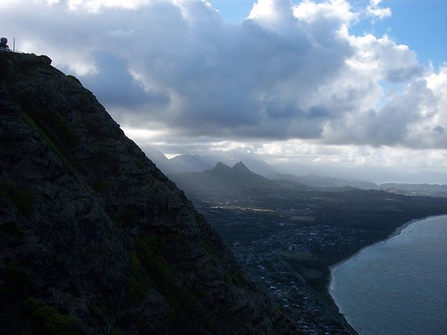
The windward side of Oahu
Photo Credit: flickr.com
Our trade winds will be gradually picking up in strength through the weekend. These trade winds will remain on the light side of the wind spectrum Saturday, but gain speed moving into Sunday. As high pressure strengthens later this weekend, our local trade winds will get a lift, becoming moderately strong as we push into the new week. The trade winds will remain with us through at least the next week.
We’ll see a few showers along the windward sides, with the chance of a shower along the leeward sides too. The night and early morning hours will be the favored time of day for the windward biased showers. The light winds, along with the daytime heating of the islands, will cause clouds to form over and around the leeward slopes during the afternoons…with a few showers. We may see an increase in showers, which could be locally heavy later this weekend into early next week.
It’s early Friday evening here in Kihei, Maui, as I begin writing this last paragraph of today’s tropical weather narrative from Hawaii. The computer models continue showing an upper level low pressure system moving over the islands this weekend. The cool air aloft in association with this upper air feature, could enhance our windward biased showers, and cause showers to increase over the leeward slopes too. ~~~ We’re heading into the last weekend of summer 2008. The official beginning of autumn occurs at 5:44am Monday morning here in the islands. Summer will give way to the autumn season with a chance of increased showers Sunday into Monday. The good part of this is that both the windward and leeward sides will have a chance to receive some much needed water. ~~~ I’m about ready to leave Kihei for the short 15-20 minute drive to Kahului. I’m going to see the new film called Righteous Kill (2008), starring Robert De Niro and Al Pacino. The long and short of this film is that a pair of veteran New York City police detectives are on the trail of a vigilante serial killer, in this adrenaline fueled psychological thriller. The critics have not been kind to this film, as an example: "Al Pacino and Robert De Niro do their best to elevate this dowdy genre exercise, but even these two greats can’t resuscitate the film’s hackneyed script." Oh well, I’m going to see it anyway, as I’m fairly easy to please, and a sucker for these kinds of action/adventure flicks. Here’s a trailer for this film. I’ll be back early Saturday morning with your next new weather narrative, including my thoughts on the film. I hope you have you have a great Friday night until then! Aloha for now…Glenn.
Interesting:
Kraft is the latest company to turn part of its waste stream into a bigger bottom line. Two cheese plants in
"Both methods required transporting the whey off-site. Now, we’re reducing the associated CO2 emissions that are part of transporting waste, discharging cleaner wastewater from our on-site treatment systems, and creating enough alternative energy to heat more than 2,600 homes in the Northeast." The company’s broader goals include reducing energy consumption and energy-related CO2 by 25 percent, and manufacturing plant waste by 15 percent. Rather than sending it to landfills, companies from across several sectors are increasingly viewing waste as a commodity. General Motors, for example, recently announced that half of its manufacturing plants worldwide would reach landfill-free status by 2010, with scrap metal sales topping $1 billion. McDonald’s successfully transformed waste into electricity earlier this year at several United Kingdom restaurants, while Chrysler is converting used paint solids from two St. Louis assembly plants into electricity. Heinz also is working on a program to transform used potato peels into energy.
Interesting2:
The Lake Tanganyika area, in southeast
Now a Brown-led research team has discovered the ITCZ may not be the key to southeast
Interesting3:
Abrupt climate change is a potential menace that hasn’t received much attention. That’s about to change. Through its Climate Change Prediction Program, the U.S. Department of Energy’s Office of Biological and Environmental Research (OBER) recently launched IMPACTS – Investigation of the Magnitudes and Probabilities of Abrupt Climate Transitions – a program led by William Collins of Berkeley Lab’s Earth Sciences Division (ESD) that brings together six national laboratories to attack the problem of abrupt climate change, or ACC. Sparked by the 2007 Nobel Peace Prize that was shared by Al Gore and the Intergovernmental Panel on Climate Change (IPCC), the reality of global warming finally got through to the majority of the world’s population. Most people think of climate change as something that occurs only gradually, however, with average temperature changing two or three degrees Celsius over a century or more; this is the rate at which ‘forcing’ mechanisms operate, such as the accumulation of carbon dioxide in the atmosphere due to the burning of fossil fuels or widespread changes in land use.
But climate change has occurred with frightening rapidity in the past and will almost certainly do so again. Perhaps the most famous example is the reverse hiccup in a warming trend that began 15,000 years ago and eventually ended the last ice age. Roughly 2,000 years after it started, the warming trend suddenly reversed, and temperatures fell back to near-glacial conditions; Earth stayed cold for over a thousand years, a period called the Younger Dryas (named for an alpine wildflower). Then warming resumed so abruptly, that global temperatures shot up 10 °C, in just 10 years. Because civilizations hadn’t yet emerged, complex human societies escaped this particular roller-coaster ride. Nevertheless, some form of abrupt climate change is highly likely in the future, with wide-ranging economic and social effects.
Interesting4:
The Caribbean and
The buildup of these communities in recent decades and the environmental damage that development has caused exacerbate the impact of hurricanes. "There’s been an explosion of population along our coast," said Amanda Staudt, a climate scientist with the National Wildlife Federation (NWF). "That’s just putting a lot more people in harm’s way." This is particularly true in