


September 1-2 2008
Air Temperatures – The following maximum temperatures were recorded across the state of Hawaii Monday afternoon:
Lihue, Kauai – 85
Honolulu, Oahu – 88
Kaneohe, Oahu – 83
Kahului, Maui – 87
Hilo, Hawaii – 83
Kailua-kona – 85
Air Temperatures ranged between these warmest and coolest spots near sea level, and on the taller mountains…at 6 p.m. Monday evening:
Port Allen, Kauai – 84F
Molokai airport – 78
Haleakala Crater- 46 (near 10,000 feet on Maui)
Mauna Kea summit – 41 (near 14,000 feet on the Big Island)
Precipitation Totals – The following numbers represent the largest precipitation totals (inches) during the last 24 hours on each of the major islands, as of Monday afternoon:
0.82 Wainiha, Kauai
0.44 South Fork Kaukonahua, Oahu
0.01 Molokai
0.00 Lanai
0.05 Kahoolawe
0.36 Puu kukui, Maui
0.97 Pahoa, Big Island
Weather Chart – Here’s the latest (automatically updated) weather map showing a 1029 millibar high pressure system located far to the northeast of Hawaii. This pressure configuration will keep our trade winds blowing generally in the light to moderately strong range…although stronger and gusty in those windiest locations.
Satellite and Radar Images: To view the cloud conditions we have here in Hawaii, please use the following satellite links, starting off with the Infrared Satellite Image of the islands to see all the clouds around the state during the day and night. This next image is one that gives close images of the islands only during the daytime hours, and is referred to as a Close-up visible image. This next image shows a larger view of the Pacific…giving perspective to the wider ranging cloud patterns in the
Aloha Paragraphs
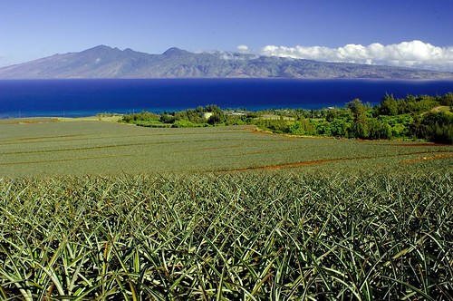
Molokai in the distance…from pineapple fields on Maui
Photo Credit: flickr.com
Light to moderately strong trade winds will remain well established over the Hawaiian Islands through the next week. As this weather map shows, we have a large 1029 millibar high pressure system far northeast of our islands now…the source of our local winds. In general, light to moderately strong trade winds will prevail…with those typically windier places having higher gusts. The winds have gotten strong enough in places around Maui and the Big Island, that small craft wind advisories have been hoisted Monday.
There will be showers at times along the windward sides through Tuesday…then drier weather will prevail by mid-week. There will be some enhancement to our windward biased showers at times, with an occasional heavy shower falling. This will be the result of cooler air aloft, associated with an upper trough of low pressure to the west of Kauai. The upcountry leeward sides could see an afternoon shower as well. Shower activity will begin to ease up some starting Wednesday.
Hurricane Gustav came ashore over the Louisiana coast early Monday morning as a category 2 storm. As this track map from the National Hurricane Center in Miami shows…the gradually weakening hurricane has already degraded into a weaker tropical storm. The winds will diminish as it continues its journey over land, although rainfall will remain heavy. Gustave will weaken further Tuesday into a tropical depression. Here’s the latest satellite image of the storm. Here is looping radar image of Gustav as it moves inland.
Meanwhile, hurricane Hanna, in the Caribbean Sea, will strengthen as it continues on towards the southeast coast of the United States. As this NHC tracking map shows, Hanna is expected to be a hurricane when it makes landfall somewhere along the South Carolina coast. Here’s what the hurricane models are showing to be the various tracks over the next several days. Here’s a satellite image of Hanna, which will take over soon as the focus in the world of hurricanes…as Gustav winds down overland and becomes a remnant low pressure system over Texas or Oklahoma by mid-week. Meanwhile, we see yet another tropical system called tropical depression 9, in the Atlantic. This tropical cyclone has recently become tropical storm Ike, and eventually hurricane Ike as it heads towards the Bahamas. Here’s a NHC tracking map of Ike.
Speaking of tropical systems, there’s an area of low pressure, what we could consider a tropical disturbance, to the south of Hawaii now. This area, which is approximately 700 miles south of Honolulu, is moving in a west-northwest direction. The upper level winds aren’t favorable for strengthening…with little if any chance of it becoming a tropical depression. Here’s a satellite image of the area, look for the small thunderstorm complex directly south of our islands. Here’s what the hurricane models are showing for what’s being called Investigation Area 95C.
It’s early Monday evening here in Kula, Maui, as I begin writing this last paragraph of today’s tropical weather narrative from Hawaii. What a great day Monday was, and it was particularly appreciated I think due to the fact it was the Labor Day holiday! I thoroughly enjoyed myself, visiting with friends, with the high point of the day spent up at the lavender farm in Waipoli…here in Kula. I loved the views from there, and it was very interesting seeing all the various varieties of lavender. Apparently there are some 200 different kinds of this wonderfully scented plant. The rest of the day I spent at home, working with my neighbors around the property. I had to drag myself indoors at sunset, as it was still so nice out there. I’m looking forward to getting back into my regular work routine starting early Tuesday morning, when I’ll meet you here again then. I hope you have a great Monday night until then! Aloha for now…Glenn.