


Hawaiian Islands weather details & Aloha paragraphs
Posted by GlennFebruary 8-9 2008
Air Temperatures – The following maximum temperatures were recorded across the state of Hawaii Friday:
Lihue, Kauai – 78
Honolulu, Oahu – 81
Kaneohe, Oahu – 77
Kahului, Maui – 78
Hilo, Hawaii – 79
Kailua-Kona, Hawaii – 80
Temperatures ranged between these warmest and coolest spots near sea level at 6 a.m. Saturday morning:
Lihue, Kauai – 72F
Barking Sands, Kauai – 65
Precipitation Totals – The following numbers represent the largest precipitation totals (inches) during the last 24 hours on each of the major islands, as of Saturday morning:
0.72 MOUNT WAIALEALE, KAUAI
1.75 MANOA LYON ARBORETUM, OAHU
0.01 MOLOKAI
0.03 LANAI
1.67 KAHOOLAWE
1.28 OHEO GULCH, MAUI
2.97 HONAUNAU, BIG ISLAND
Weather Chart – Here’s the latest (automatically updated) weather map. High pressure systems, one to the NNE and another to the NE, will merge to the NE soon. This pressure configuration will keep light-moderately strong trade winds blowing…gradually picking up a little in strength Sunday into the new week ahead. Here’s a Weather Map Symbol page for clarification about what all those weather symbols mean on the map.
Satellite and Radar Images: To view the cloud conditions we have here in Hawaii, please use the following satellite links, starting off with the Infrared Satellite Image of the islands to see all the clouds around the state during the day and night. This next image is one that gives close images of the islands only during the daytime hours, and is referred to as a Close-up visible image. This next image shows a larger view of the Pacific…giving perspective to the wider ranging cloud patterns in the Pacific Ocean…out from the islands. To help you keep track of where any showers may be around the islands, here’s the latest animated radar image.
Hawaii’s Mountains – Here’s a link to the live webcam on the summit of near 14,000 foot Mauna Kea on the Big Island of Hawaii. The tallest peak on the island of Maui is the Haleakala Crater, which is near 10,000 feet in elevation. These two webcams are available during the daylight hours here in the islands…and when there’s a big moon rising just after sunset for an hour or two! Plus, during the nights and early mornings you will be able to see stars, and the sunrise too…depending upon cloud conditions.
Aloha Paragraphs
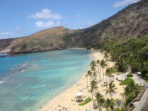
Hanama Bay, Oahu
The trade winds, after a day or two of being quite light, will gradually increase a notch this weekend. The latest weather map shows a 1031 millibar high pressure system located far to the northeast of Hawaii now. A new high pressure cell will reinforce the one already in the eastern Pacific soon. Forecast weather charts suggest that the trade winds will continue right on into the new week ahead. They won’t be too strong, nor will they be too light…turning out to be light to moderate, which is just about perfect during the month of February.
It’s Friday evening as I begin updating this last paragraph of today’s narrative. Today the trade winds picked up a little more speed than expected, which took the edge off the afternoon convective rainfall…at least a little. Nonetheless, the Big Island still took a pretty big hit in terms of localized downpours. The NWS forecast office in Honolulu kept flood watches and warnings up most of the day. Let’s just put it this way, it has been excessively wet over many areas on the Big Island lately, to say the least! This doesn’t come unexpectedly however, as typically a La Nina winter here in the islands includes wetter than normal weather. By the way, La Nina is simply cooler than normal sea water temperatures in the eastern and central tropical Pacific…which influences weather worldwide. The ENSO forecast calls for continued La Nina conditions prevailing through the rest of this winter, into the spring months. ~~~ As pointed out in the two paragraphs above, we are close to being back into better weather, very close folks! This weekend into the new week ahead should prove to be much nicer, with the Chamber of Commerce folks finally remembering how to smile again
 ~~~ This evening I’m going to see a film called I am Legend (2007). Will Smith stars in a post-apocalyptic thriller as the last human survivor on earth after a terrible mutating virus wipes out humanity. It actually received pretty good ratings, I had put off seeing it, but with nothing else playing that I want to see, or haven’t already seen, I’ll try it out. If you’re interested, here’s a trailer for this thriller. To tell you the truth, one of the main reasons I didn’t want to seen this film was because it looks like German Shephard, Will’s side kick, gets killed in the end. I can take humans getting knocked off in films, but watching animals going down is another story! I’ll have to advert my eyes during that scene. I’ll let you know what I thought about it when I come back Saturday with your next new weather narrative from paradise. I hope you have a great Friday night wherever you happen to be spending it! Aloha for now…Glenn.
Glenn’s TV Weather show is back online again now. The colors aren’t perfect, although they are close enough. One day’s show will replaced with the next new days show at around 9am HST (11am PST – 2pm EST). Thanks to the folks at the Maui Media Lab in Paia for making this happen!