


Hawaiian Islands weather details & Aloha paragraphs
Posted by GlennFebruary 5-6 2008
Air Temperatures – The following maximum temperatures were recorded across the state of Hawaii Tuesday:
Lihue, Kauai – 78
Honolulu, Oahu – 79
Kaneohe, Oahu – 74
Kahului, Maui – 73
Hilo, Hawaii – 71
Kailua-Kona, Hawaii – 79
Temperatures ranged between these warmest and coolest spots near sea level at 4 a.m. Wednesday morning:
Lihue, Kauai – 73F
Kahului, Maui – 64
Precipitation Totals – The following numbers represent the largest precipitation totals (inches) during the last 24 hours on each of the major islands, as of Wednesday morning:
5.72 MOUNT WAIALEALE, KAUAI
2.06 MANOA LYON ARBORETUM, OAHU
0.01 MOLOKAI
0.10 LANAI
0.13 KAHOOLAWE
5.37 PUU KUKUI, MAUI
4.20 HILO AIRPORT, BIG ISLAND
Weather Chart – Here’s the latest (automatically updated) weather map. A 1034 millibar high pressure system is located far to the NE of the islands…with its associated ridge extending westward…to the north of Hawii. This pressure configuration will keep moderately strong trade winds blowing Wednesday…getting lighter Thursday. Here’s a Weather Map Symbol page for clarification about what all those weather symbols mean on the map.
Satellite and Radar Images: To view the cloud conditions we have here in Hawaii, please use the following satellite links, starting off with the Infrared Satellite Image of the islands to see all the clouds around the state during the day and night. This next image is one that gives close images of the islands only during the daytime hours, and is referred to as a Close-up visible image. This next image shows a larger view of the Pacific…giving perspective to the wider ranging cloud patterns in the Pacific Ocean…out from the islands. To help you keep track of where any showers may be around the islands, here’s the latest animated radar image.
Hawaii’s Mountains – Here’s a link to the live webcam on the summit of near 14,000 foot Mauna Kea on the Big Island of Hawaii. The tallest peak on the island of Maui is the Haleakala Crater, which is near 10,000 feet in elevation. These two webcams are available during the daylight hours here in the islands…and when there’s a big moon rising just after sunset for an hour or two! Plus, during the nights and early mornings you will be able to see stars, and the sunrise too…depending upon cloud conditions.
Just when it started to look like we’d see a possible break in the showery weather, showers, even locally heavy ones…may continue through Friday. The incoming showery clouds don’t seem to want to stop, marching along our windward sides like nobody’s business! Since the trade winds prevail, there will be continued passing showers, unfortunately focusing their efforts most effectively over the windward sides of the Big Island and Maui, although Oahu and Kauai won’t be immune. As the weekend gets here, there’s a good chance that our local weather will transform itself back towards the sunnier side of the weather spectrum.
It’s Tuesday evening as I begin updating last paragraph of today’s narrative. Today was anything but a banner day for sunshine, with lots of high clouds, not to mention the middle and low varieties, hiding our famous Hawaiian sunshine once again.
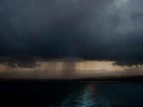
This looping satellite image shows the situation well. Those cirrus clouds will hold back the sun for the time being, although these icy clouds up high aren’t rain producers at least. Speaking of precipitation, there is still lots of water falling from the sky around…some of which has become locally heavy again. A flash flood watch has been reinstituted for the already soggy Big Island. This looping radar image shows waves of showers impacting the Big Island…stretching up over parts of Maui and Oahu as well. The Big Island does not need anymore rainfall, especially from Kau to Puna and up along the windward sides! ~~~ Most of Tuesday was totally cloudy, with showers not uncommon. Tuesday evening heavy rain was once again falling along the windward sides of the Big Island, this is getting to be really out of hand. The windward sides of Maui too, are exceptionally soggy and wet. Oahu, up the island chain, isn’t fairing much better, with copious rainfall a common visitor along the east and north facing slopes of the Koolau Mountains. The big question of course becomes: when will it stop! Well, it looked like it might back off there yesterday and earlier today, but now, well, it looks like we’ll have to wait until Friday or the weekend for some substantial relief. ~~~ I hope it’s drier where you are, as even here in Kihei, Maui, we had some brief showers around Tuesday. When it rains in Kihei, you know it’s a wet period! At any rate, I’ll be back with your next new weather narrative from our less than perfect paradise very early Wednesday morning. I hope you have a great Tuesday night wherever you happen to be spending it! Aloha for now…Glenn.Interesting: To help figure out how to create a flapping wing plane that will stand up to extreme wind and weather scientists are turning to nature for the answer.
Natural flyers like birds, bats and insects outperform man-made aircraft in aerobatics and efficiency. University of Michigan engineers are studying these animals as a step toward designing flapping-wing planes with wingspans smaller than a deck of playing cards.
A Blackbird jet flying nearly 2,000 miles per hour covers 32 body lengths per second. But a common pigeon flying at 50 miles per hour covers 75.
The roll rate of the aerobatic A-4 Skyhawk plane is about 720 degrees per second. The roll rate of a barn swallow exceeds 5,000 degrees per second.
Select military aircraft can withstand gravitational forces of 8-10 G. Many birds routinely experience positive G-forces greater than 10 G and up to 14 G.
Interesting2: It’s National Weatherman’s Day Tuesday! "National Weatherman’s Day honors weathermen, and woman who work hard to accurately predict the often fickle weather. Despite major technological advances and supercomputers, forecasting the weather is still a tricky, and ever changing business.
According to the Air Force News, Weatherman’s Day "commemorates the birth of John Jeffries, one of America’s first weathermen". Jeffries was born on Feb 5, 1744. He kept weather records from 1774 to1816.
If you see a weatherman today, give them your appreciation for a job well done.