


Hawaiian Islands weather details & Aloha paragraphs
Posted by GlennFebruary 1-2 2008
Air Temperatures – The following maximum temperatures were recorded across the state of Hawaii Friday:
Lihue, Kauai – 73
Honolulu, Oahu – 80
Kaneohe, Oahu – 76
Kahului, Maui – 74
Hilo, Hawaii – 76
Kailua-Kona, Hawaii – 81
Temperatures ranged between these warmest and coolest spots near sea level at 5 a.m. Saturday morning:
Honolulu, Oahu – 73F
Barking Sands, Kauai – 66
Precipitation Totals – The following numbers represent the largest precipitation totals (inches) during the last 24 hours on each of the major islands, as of Saturday morning:
3.80 MOUNT WAIALEALE, KAUAI
1.34 POAMOHO 2, OAHU
0.34 MOLOKAI
0.00 LANAI
0.00 KAHOOLAWE
7.97 PUU KUKUI, MAUI
11.03 WAIAKEA UKA, BIG ISLAND
Weather Chart – Here’s the latest (automatically updated) weather map. A robust 1036 millibar high pressure system remains locked into place north-northeast of the islands, which will keep moderate to locally strong and gusty trade winds blowing across our area through Sunday. Here’s a Weather Map Symbol page for clarification about what all those weather symbols mean on the map.
Satellite and Radar Images: To view the cloud conditions we have here in Hawaii, please use the following satellite links, starting off with the Infrared Satellite Image of the islands to see all the clouds around the state during the day and night. This next image is one that gives close images of the islands only during the daytime hours, and is referred to as a Close-up visible image. This next image shows a larger view of the Pacific…giving perspective to the wider ranging cloud patterns in the Pacific Ocean…out from the islands. To help you keep track of where any showers may be around the islands, here’s the latest animated radar image.
Hawaii’s Mountains – Here’s a link to the live webcam on the summit of near 14,000 foot Mauna Kea on the Big Island of Hawaii. The tallest peak on the island of Maui is the Haleakala Crater, which is near 10,000 feet in elevation. These two webcams are available during the daylight hours here in the islands…and when there’s a big moon rising just after sunset for an hour or two! Plus, during the nights and early mornings you will be able to see stars, and the sunrise too…depending upon cloud conditions.
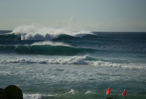
Winter surf in Hawaii
photo credit: flickr.com
Incoming showers, carried by the trade winds, will keep the windward sides wet…with some showers spreading over to the leeward sides locally. These incoming showery clouds will be numerous…some of which may be briefly heavy. The upper level low pressure system, which brought snow to the mountains recently, has moved away to the northeast. It’s associated trough however, will remain near the islands. This in turn will keep the trade wind inversion high or non-existent…which means thicker clouds. Thus, showers will be more active than normal through the weekend. Looking further ahead, the latest computer models show a low pressure system developing to the southwest of Hawaii, which may pull up deep moisture from the SE, keeping rain in the forecast into the new week, especially on the windward sides on Maui and the Big Island.
It’s Friday evening as I begin updating this last paragraph of today’s narrative. As noted in the two paragraphs above, its going to continue to be rather windy and locally wet along the windward coasts and slopes. The latest forecast models are locking onto the distinct possibility of continued wet conditions there even after the weekend. I’ve held off on saying too much about this increase in showers early in the new week ahead, but since the models are becoming more aligned in there solutions, we have to take this threat more seriously. As we move into the new week ahead, we could likely see more showers arriving along the already wet windward sides. There is the chance of localized flooding, although thunderstorms aren’t in the forecast at this point…fortunately. We’ll need to keep an eye on this situation, as tropical moisture from the SE moves up over Maui and the Big Island end of the chain. ~~~ I’m about to leave Kihei, and head over to Wailuku, where I’m meeting some friends. The occasion is something called First Friday, which simply means a social occasion on the 1st Friday of the month. I hadn’t heard of this before, but will check it out…not sure what to expect. It would be nice to have a drink, and be able to do some dancing! ~~~ Before I leave however, I want to put a link to this looping satellite image, which shows the copious amount of high cirrus clouds being drawn over the islands now. They may stick around through the weekend, giving great sunset and sunrise colors, although will dim and filter our sunshine during the days. I hope you have a great Friday night, I’ll of course be back on Saturday with your next weather narrative from paradise! Aloha for now…Glenn.
Interesting: China is beginning to take advantage of an unusual energy source – cow gas. Cows emit a significant amount of methane, a powerful greenhouse gas, when they belch and flatulate. According to People’s Daily, the world’s largest cow-dung methane power plant started operation on January 21 in
Interesting2: A 24-year-old German medical student described Friday how she used mouth-to-mouth resuscitation to revive a tiger cub that nearly choked to death on a chunk of meat. Janine Bauer, who was visiting the Berg Zoo in December with her one-year-old son Johann, asked a keeper to let her into the pen and to hold the prone feline down while she cleared its airway, gave heart massage and revived it with the kiss of life. The zoo in Halle, eastern Germany did not make the incident public at the time. Bauer told MDR television in Halle that the young Malayan tiger appeared to have been too greedy to chew its food properly: "I saw him shiver, fall over, twitch a bit and become immobile. "It took three to five minutes, but he revived in the end." In gratitude, the zoo has named the tiger Johann after her son.