May 2008
Monthly Archive
Posted by Glenn
1 Comment
May 31 – June 1 2008
Air Temperatures – The following maximum temperatures were recorded across the state of Hawaii Saturday:
Lihue, Kauai – 83
Honolulu, Oahu – 87
Kaneohe, Oahu – 78
Kahului, Maui – 87
Hilo, Hawaii – 82
Kailua-kona – 84
Air Temperatures ranged between these warmest and coolest spots near sea level at 4 p.m. Saturday afternoon:
Barking Sands, Kauai – 85F
Kailua-kona – 79
Precipitation Totals – The following numbers represent the largest precipitation totals (inches) during the last 24 hours on each of the major islands, as of Saturday afternoon:
0.11 Mount Waialeale, Kauai
0.02 Poamoho 2, Oahu
0.00 Molokai
0.00 Lanai
0.00 Kahoolawe
0.17 Oheo Gulch, Maui
0.17 Kamuela Upper, Big Island
Weather Chart – Here’s the latest (automatically updated) weather map showing high pressure systems strung out from the northwest through northeast of the state of Hawaii. These high pressure cells, along with their associated ridges, will keep moderately strong trade winds blowing across the state through Sunday…locally stronger and gusty in those windiest areas.
Satellite and Radar Images: To view the cloud conditions we have here in Hawaii, please use the following satellite links, starting off with the Infrared Satellite Image of the islands to see all the clouds around the state during the day and night. This next image is one that gives close images of the islands only during the daytime hours, and is referred to as a Close-up visible image. This next image shows a larger view of the Pacific…giving perspective to the wider ranging cloud patterns in the Pacific Ocean…out from the islands. To help you keep track of where any showers may be around the islands, here’s the latest animated radar image.
Hawaii’s Mountains – Here’s a link to the live webcam on the summit of near 14,000 foot Mauna Kea on the Big Island of Hawaii. The tallest peak on the island of Maui is the Haleakala Crater, which is near 10,000 feet in elevation. These two webcams are available during the daylight hours here in the islands…and when there’s a big moon rising just after sunset for an hour or two! Plus, during the nights and early mornings you will be able to see stars, and the sunrise too…depending upon cloud conditions.
Aloha Paragraphs
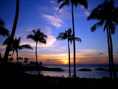
The end of another perfect day here in Hawaii
Photo Credit: flickr.com
The trade winds will be quite blustery Sunday into Monday. These trades are strong enough now, that small craft wind advisory flags remain up in the windiest places around Maui and the Big Island. The latest forecast calls for these stronger than normal trades to drop back down into the more normal light to moderately strong realms after the weekend.
The dry weather we’ve seen lately will continue through Sunday. The windward sides will pick up whatever few showers that are around. The leeward sides will find dry weather, with plenty of sunshine. We still expect to see some increase in showers right after the weekend, as the moisture associated with an old cold front gets carried onto the windward sides Monday…last for a day or two.
~~~ As mentioned in the paragraph above, there’s a retired cold front that’s been hanging out to the north of the islands most of this week. The computer forecast models continue showing that the remnant moisture will get carried our way on the trade winds starting Monday. As a matter of fact, there’s a second chance for showers, later in the week, when an upper level trough of low pressure moves into our area…which could bring another surge of wet trade winds into our area.
~~~ I have my fingers crossed, that at least one…and hopefully both of those potential showery episodes manifest as the models suggest. The Hawaiian Islands are dry, too dry as we head into our summer dry season. The spring rains that we usually get, didn’t give us nearly enough water this year. I wouldn’t go so far as to call it bone dry, but there’s no doubt that we need some rainy weather. The bulk of the showers that I spoke of in the two paragraphs above, will arrive along the windward sides.
~~~ I had a great time surfing over on the Lahaina side this morning! The waves were small as I expected, although that kept the crowds down. The winds were very light while I was there, which made for very smooth ocean conditions. This smooth water is referred to as glassy in the surfing community. I got lots of rides, several of which made me happy. I decided to drive to the north shore afterwards, and took a nice walk on the sandy beach near Paia…dipping into the warm ocean again there. My feeling is you can’t get into the ocean too much! I couldn’t resist swinging by the Maui Country Club in Spreckelsville again, to try my hand at putting…although I didn’t do all that well. My concentration was off a bit, but it felt good being on the green there anyway.
~~~ I’ve been home for the rest of the day, enjoying the tranquility of Kula, Maui. I’m celebrating a little, don’t ask me why though. I just popped a bottle of 1995 Champagne Henriot, Brut Millesime, from Reims, France. It’s tasty, and I believe it’s the first bubbly that I’ve ever had that wasn’t non-vintage. I’ve had a glass, and those bubbles are going straight to my head. The sun is still shining brightly, with just a few rather shallow clouds banked up against the slopes of the Haleakala Crater. Looking over towards the beaches, both towards the north and south shores, it looks near totally clear. This Maui weatherman is on to the next thing, whatever that may be. I’ll meet you here again Sunday morning however, and before I sign off, would like to wish you a great Saturday night wherever you’re reading from! Aloha for now…Glenn.
An unknown fact: the two songs below have been a couple of my favorites through the years:
Tears for Fears – Head over heels
Simply Red – Stars
Posted by Glenn
No Comments
May 30-31 2008
Air Temperatures – The following maximum temperatures were recorded across the state of Hawaii Friday:
Lihue, Kauai – 83
Honolulu, Oahu – 86
Kaneohe, Oahu – 81
Kahului, Maui – 85
Hilo, Hawaii – 82
Kailua-kona – 83
Air Temperatures ranged between these warmest and coolest spots near sea level at 4 p.m. Friday afternoon:
Kahului, Maui – 85F
Hilo, Hawaii – 78
Precipitation Totals – The following numbers represent the largest precipitation totals (inches) during the last 24 hours on each of the major islands, as of Friday afternoon:
0.10 Mount Waialeale, Kauai
0.01 Waimanalo, Oahu
0.00 Molokai
0.00 Lanai
0.00 Kahoolawe
0.05 Puu Kukui, Maui
0.33 Hilo airport, Big Island
Weather Chart – Here’s the latest (automatically updated) weather map showing high pressure systems strung out to the northwest through northeast of the state of Hawaii now. These high pressure cells, along with their associated ridges, will keep moderately strong trade winds blowing across the state through Sunday…becoming locally stronger and gusty, topping 30 knots in those windiest areas.
Satellite and Radar Images: To view the cloud conditions we have here in Hawaii, please use the following satellite links, starting off with the Infrared Satellite Image of the islands to see all the clouds around the state during the day and night. This next image is one that gives close images of the islands only during the daytime hours, and is referred to as a Close-up visible image. This next image shows a larger view of the Pacific…giving perspective to the wider ranging cloud patterns in the Pacific Ocean…out from the islands. To help you keep track of where any showers may be around the islands, here’s the latest animated radar image.
Hawaii’s Mountains – Here’s a link to the live webcam on the summit of near 14,000 foot Mauna Kea on the Big Island of Hawaii. The tallest peak on the island of Maui is the Haleakala Crater, which is near 10,000 feet in elevation. These two webcams are available during the daylight hours here in the islands…and when there’s a big moon rising just after sunset for an hour or two! Plus, during the nights and early mornings you will be able to see stars, and the sunrise too…depending upon cloud conditions.
Aloha Paragraphs


Magnificent dolphin jumps here in Hawaii
Photo Credit: flickr.com
The trade winds will become fairly blustery over the next couple of days. Wind speeds ramped-up into the moderately strong category Friday, and then even more so as we move into the weekend. Wind speeds will become strong enough by Saturday, that we’ll likely see small craft wind advisory flags being raised in the windiest places around Maui and the Big Island. The computer forecast models show no end to these late spring trade winds from this vantage point.
Despite the solid trade wind flow, there won’t be many showers falling here in the islands. The windward sides would be where those few showers would fall generally. The leeward sides will find dry weather, although on the Kona slopes, the usual afternoon cloudiness will develop, where there may be a few light showers. There is a hope that we will see some increase in showers right after the weekend, as a retired cold front gets carried onto the windward sides by Monday into Tuesday…and then again later in the week.
~~~ As is often the case, there’s one weather feature that captures our attention over most of the others. Here in the Hawaiian Islands, I’m afraid that that feature may turn out to be dry weather conditions this summer. We generally count on having springtime showers, especially along the windward sides, which bring enough water to aquifers and upcountry reservoirs…to carry us through our summer dry period. The month of April in particular, is usually a good one in regards to receiving lots of incoming trade wind showers. April was not a good rain producer however, and May hasn’t been very impressive either. This leaves us lacking in the precipitation department!
~~~ Looking ahead, our next best chance for showers may be coming up right after the weekend. As I mentioned in one of the paragraphs above, there’s an old cold front hanging out to the north of the islands, and has been most of this week. It has been blocked from progressing southward so far. The computer forecast models however continue showing that the fronts moisture may eventually get carried our way on the trade winds after the weekend. This could bring us some much needed showers, although by themselves, won’t be nearly enough to bring us back up to a normal amount of rainfall for this time of year. I should add however, that at this point any moisture would be helpful! Let’s hope that we might see some showers during the new week ahead, although working against us…is the fact that June is the driest month of the year in most places in Hawaii!
~~~ I just finished work here in Kihei, Maui, and am ready to start my weekend. I just looked out the window, and found a near cloud free sky! It’s really very clear out there, with tons of sunshine beaming down over the south coast. The winds look pretty frisky, with the palm trees bending over nicely under their influence. Looking at the wind reports around the state at the 5pm hour, the two strongest gusts that I see are both here on Maui. The Kahului airport was showing 31 mph, with Maalaea Bay topping out at 36 mph. Just for comparison’s sake, the lightest wind speed at the same time, were being reported at the Kona airport…at just 6 mph.
~~~ Nothing’s really catching my eye at the movies this evening, so I’ll have to turn my attention to something else. I may just head to the shopping center, as I need to pick up something, and then from there, it’s anyones guess. I have a thought to go into Wailuku town, maybe have a glass of wine. Then again, there’s always a putting green waiting at one of the local Country Clubs as well. I honestly don’t know exactly what I’ll end up doing. I have a strong idea to get over to the Lahaina side early Saturday morning for a surfing session, which sounds very enticing at the moment. At any rate, I’ll be back here early to very early Saturday morning with your next new weather narrative from paradise. I hope you have a great Friday night whatever you’re doing! Aloha for now…Glenn.
Interesting: All but one of the top 10 U.S. metropolitan areas that release the most greenhouse gases on a per capita basis lie east of the Mississippi River, a study released on Thursday showed. "A north-south divide is also apparent," as seven of the highest emitters of greenhouse gases are located in the south, including two from each of three states, Tennessee, Ohio and Kentucky, according to the report by the Regional Plan Association, a New York-based think tank. Honolulu was the greenest U.S. metro area, with a carbon footprint of only 1.356 metric tons per resident in 2005. he analysis only counted greenhouse gases from buildings and transportation, excluding utilities, for example. The second greenest on the list of the top 100 metropolitan areas was Los Angeles-Long Beach-Santa Ana, followed by Portland-Vancouver-Beaverton, Oregon–Washington. Coming in fourth was New York-Northern New Jersey-Long Island, New York-New Jersey–Pennsylvania. Fifth-ranked was Boise City-Nampa, Idaho. The worst polluter was the metropolitan area of Lexington-Fayette, Kentucky, which ranked last at 100. Indianapolis, Indiana, was 99th, Cincinnati-Middletown, Ohio-Kentucky-Indiana was 98th, and Toledo, Ohio was 97th. Louisville, Kentucky-Indiana came in 96th, with Nashville-Davidson-Murfreesboro, Tennessee ranking 95th. The West was the only part of the nation that cut its carbon footprint from 2000 to 2005, according to the report.
Interesting2: A new way to make greener asphalt for U.S. highways and byways isn’t new at all. They’ve been doing it for decades in Africa and India. Asphalt is the sticky byproduct left after fuel and lubricating oil are extracted from crude petroleum. It’s too thick to be laid on roads as is, so in the United States it’s heated to as much as 300 degrees Fahrenheit to make it easy to pump and apply. A new national research program called the Asphalt Research Consortium (ARC) aims to make asphalt cheaper and more environmentally friendly to produce. That means it might, for example, last longer, or use recycled material, or be manufactured using less energy. There’s good reason for the effort: America has more than 4 million miles of roads. The only place you can be 22 miles away from a road in the contiguous states is a spot in the southeast corner of YellowstoneNational Park in Wyoming. In other countries, so-called cold-mix asphalts save up to seven times the energy of the hot-mix counterparts, according to University of Wisconsin-Madison civil engineering professor Hussain Bahia.
Interesting3: Mankind is causing 50 billion euros ($78 billion) of damage to the planet’s land areas every year, making it imperative governments act to save plants and animals, a Deutsche Bank official told a U.N. conference. A study, presented to delegates from 191 countries in the U.N.’s Convention on Biological Diversity on Thursday, said recent pressure on commodity and food prices highlighted the effects of the loss of biodiversity to society. "Urgent remedial action is essential because species loss and ecosystem degradation are inextricably linked to human well-being," said Pavan Sukhdev, a banker at Deutsche Bank and the main author of the report. On top of the current 50 billion euros annual loss from land-based ecosystems caused by factors including pollution and deforestation, the cumulative loss could amount to at least 7 percent of annual consumption by 2050, said the report. Deforestation, if continued at current levels, would cost some 6 percent of world gross domestic product by 2050, he said. The idea of the report is to spur action to safeguard wildlife in the way Britain‘s Stern report sparked action to fight climate change after the economic costs were outlined, German Environment Minister Sigmar Gabriel said. European Environment Commissioner Stavros Dimas said the study proved biodiversity was not just about saving pandas and tigers but underscored the need to preserve natural wealth. "The report shows we are eating away at our natural capital and making ourselves vulnerable to climate change," he said.
Posted by Glenn
No Comments
May 29-30 2008
Air Temperatures – The following maximum temperatures were recorded across the state of Hawaii Thursday:
Lihue, Kauai – 83
Honolulu, Oahu – 88
Kaneohe, Oahu – 82
Kahului, Maui – 86
Hilo, Hawaii – 84
Kailua-kona – 85
Air Temperatures ranged between these warmest and coolest spots near sea level at 5 p.m. Thursday evening:
Barking Sands, Kauai – 84F
Kaneohe, Oahu – 79
Precipitation Totals – The following numbers represent the largest precipitation totals (inches) during the last 24 hours on each of the major islands, as of Thursday morning:
0.49 Mount Waialeale, Kauai
0.68 Poamoho 2, Oahu
0.01 Molokai
0.00 Lanai
0.00 Kahoolawe
0.03 Oheo Gulch, Maui
0.35 Glenwood, Big Island
Weather Chart – Here’s the latest (automatically updated) weather map showing high pressure systems strung out to the northwest through northeast of the state of Hawaii now. This high pressure cells, along with their associated ridges, will keep moderately strong trade winds blowing across the state Friday…becoming locally stronger and gusty, topping 30 knots in those windiest areas into Saturday.
Satellite and Radar Images: To view the cloud conditions we have here in Hawaii, please use the following satellite links, starting off with the Infrared Satellite Image of the islands to see all the clouds around the state during the day and night. This next image is one that gives close images of the islands only during the daytime hours, and is referred to as a Close-up visible image. This next image shows a larger view of the Pacific…giving perspective to the wider ranging cloud patterns in the Pacific Ocean…out from the islands. To help you keep track of where any showers may be around the islands, here’s the latest animated radar image.
Hawaii’s Mountains – Here’s a link to the live webcam on the summit of near 14,000 foot Mauna Kea on the Big Island of Hawaii. The tallest peak on the island of Maui is the Haleakala Crater, which is near 10,000 feet in elevation. These two webcams are available during the daylight hours here in the islands…and when there’s a big moon rising just after sunset for an hour or two! Plus, during the nights and early mornings you will be able to see stars, and the sunrise too…depending upon cloud conditions.
Aloha Paragraphs
 Black and white…Oheo Gulch, east Maui

Closer view…in color
Photo Credit: flickr.com
The brisk trade winds will be around for the long haul here in the Hawaiian Islands. Wind speeds have increased into the moderately strong category Thursday evening, gradually increasing further in strength later Friday into the weekend. Wind speeds will become strong enough by Saturday, that we’ll likely see small craft wind advisory flags being hoisted in the windiest places around Maui and the Big Island. The computer forecast models show no end to these late spring trade winds at this point.
There will be a few showers around, although nothing heavy or widespread is indicated for the time being. The leeward sides will find dry weather, with the Kona slopes being the one standout, where the usual afternoon cloudiness may drop some generally light showers. As the trade winds increase a notch this weekend, we will likely see some increase in showers right after the weekend, as a retired cold front gets carried onto the windward sides by Monday into Tuesday.
~~~ Despite the fact that we’re seeing a few showers falling locally, it’s dry here in the islands. Dry enough in fact, that water usage is being restricted in some locales…although at this point, it’s still voluntary. If we continue to remain as dry as we are presently, mandatory water restrictions are a definite possibility during our normally dry summer months. Our next best chance for picking up some moisture would be right after this weekend, when an old cold front arrives at about the same time an upper level trough of low pressure gets here. Otherwise, we may have to wait until some tropical system moves close to the islands this summer.
~~~ Speaking of tropical systems, we find the first tropical cyclone of the 2008 hurricane season now having flared-up in the eastern Pacific. Tropical storm Alma is spinning just off the coast of Nicaragua. Here’s a National Hurricane Center storm track map, showing it getting ready to move overland, where it will lose steam quickly. Here in the central Pacific our 2008 hurricane season doesn’t begin until June 1st, two weeks after the eastern Pacific’s start date. We are expecting slightly less than the normal number of storms here in the central Pacific this year…which is a good thing.
~~~ Thursday was yet another nice day, they just keep coming our way, which of course is a good thing! The winds were up today, while rainfall was down. This pattern will continue through the rest of this week, with increasingly strong trade winds, which will be carrying very little in the way of showers. The overlying atmosphere is very dry and stable, which will keep island skies quite sunny during the days, along with seasonably warm to very warm days…especially along the sun drenched leeward coasts. Looking out the window here in Kihei, before I leave for the drive upcountry to Kula, it is sunny, sunny, and more sunny out there! I’ll be back again very early Friday morning, when I’ll be talking about just how dry it is, and what that means for us as we head into summer. I hope you have a great Thursday night wherever you happen to be spending it! Aloha for now…Glenn.
Interesting: All but one of the top 10 U.S. metropolitan areas that release the most greenhouse gases on a per capita basis lie east of the Mississippi River, a study released on Thursday showed. "A north-south divide is also apparent," as seven of the highest emitters of greenhouse gases are located in the south, including two from each of three states, Tennessee, Ohio and Kentucky, according to the report by the Regional Plan Association, a New York-based think tank. Honolulu was the greenest U.S. metro area, with a carbon footprint of only 1.356 metric tons per resident in 2005. he analysis only counted greenhouse gases from buildings and transportation, excluding utilities, for example. The second greenest on the list of the top 100 metropolitan areas was Los Angeles-Long Beach-Santa Ana, followed by Portland-Vancouver-Beaverton, Oregon–Washington. Coming in fourth was New York-Northern New Jersey-Long Island, New York-New Jersey–Pennsylvania. Fifth-ranked was Boise City-Nampa, Idaho. The worst polluter was the metropolitan area of Lexington-Fayette, Kentucky, which ranked last at 100. Indianapolis, Indiana, was 99th, Cincinnati-Middletown, Ohio-Kentucky-Indiana was 98th, and Toledo, Ohio was 97th. Louisville, Kentucky-Indiana came in 96th, with Nashville-Davidson-Murfreesboro, Tennessee ranking 95th. The West was the only part of the nation that cut its carbon footprint from 2000 to 2005, according to the report.
Interesting2: A new way to make greener asphalt for U.S. highways and byways isn’t new at all. They’ve been doing it for decades in Africa and India. Asphalt is the sticky byproduct left after fuel and lubricating oil are extracted from crude petroleum. It’s too thick to be laid on roads as is, so in the United States it’s heated to as much as 300 degrees Fahrenheit to make it easy to pump and apply. A new national research program called the Asphalt Research Consortium (ARC) aims to make asphalt cheaper and more environmentally friendly to produce. That means it might, for example, last longer, or use recycled material, or be manufactured using less energy. There’s good reason for the effort: America has more than 4 million miles of roads. The only place you can be 22 miles away from a road in the contiguous states is a spot in the southeast corner of Yellowstone National Park in Wyoming. In other countries, so-called cold-mix asphalts save up to seven times the energy of the hot-mix counterparts, according to University of Wisconsin-Madison civil engineering professor Hussain Bahia.
Posted by Glenn
No Comments
May 28-29 2008
Air Temperatures – The following maximum temperatures were recorded across the state of Hawaii Wednesday:
Lihue, Kauai – 83
Honolulu, Oahu – 88
Kaneohe, Oahu – 82
Kahului, Maui – 88
Hilo, Hawaii – 84
Kailua-kona – 85
Air Temperatures ranged between these warmest and coolest spots near sea level at 4 p.m. Wednesday afternoon:
Honolulu, Oahu – 86F
Hilo, Hawaii – 78
Precipitation Totals – The following numbers represent the largest precipitation totals (inches) during the last 24 hours on each of the major islands, as of Wednesday afternoon:
0.88 Mount Waialeale, Kauai
0.70 Manoa Valley, Oahu
0.00 Molokai
0.00 Lanai
0.00 Kahoolawe
0.04 Oheo Gulch, Maui
0.34 Glenwood, Big Island
Weather Chart – Here’s the latest (automatically updated) weather map showing a 1026 millibar high pressure system far to the north-northeast of the state of Hawaii now. This high pressure cell, with its associated ridges, will keep light to moderately strong trade winds blowing across the state into Friday…locally gusty in those windiest areas.
Satellite and Radar Images: To view the cloud conditions we have here in Hawaii, please use the following satellite links, starting off with the Infrared Satellite Image of the islands to see all the clouds around the state during the day and night. This next image is one that gives close images of the islands only during the daytime hours, and is referred to as a Close-up visible image. This next image shows a larger view of the Pacific…giving perspective to the wider ranging cloud patterns in the Pacific Ocean…out from the islands. To help you keep track of where any showers may be around the islands, here’s the latest animated radar image.
Hawaii’s Mountains – Here’s a link to the live webcam on the summit of near 14,000 foot Mauna Kea on the Big Island of Hawaii. The tallest peak on the island of Maui is the Haleakala Crater, which is near 10,000 feet in elevation. These two webcams are available during the daylight hours here in the islands…and when there’s a big moon rising just after sunset for an hour or two! Plus, during the nights and early mornings you will be able to see stars, and the sunrise too…depending upon cloud conditions.
Aloha Paragraphs
 Out along the Hana, Maui coastline
Photo Credit: flickr.com
There’s no end in sight for the trade winds, although they will be slightly lighter now through Thursday into Friday. Wind speeds will remain in the light to moderately strong range. High pressure will remain anchored in the area north through northeast of Hawaii, which will be the source of our long lasting trade wind weather pattern. As the weekend rolls around, the trade winds are expected to boost up into the moderately strong category…continuing into next week.
A few showers will fall along the windward sides, although generally quite light precipitation totals are expected through Friday. The leeward sides will find dry weather, with the only exception being Kona slopes, where the usual afternoon cloudiness may drop a couple of light showers. As the trade winds increase a notch this weekend, we will likely see some increase in showers right after the weekend, although once again…the bias will remain focused along the windward sides.
~~~ The calender may tell us that we’re still in the spring season, although the weather here in the islands…sure has the look and feel of summer now! The days are getting warmer and warmer, which in turn is prompting the surrounding ocean to gain warmth as well. These two, working in tandem, make it seem like we should have already reached the summer solstice, which is of course June 21st or so. It won’t be long before we see our maximum temperatures, at those warmest sea level locations, topping out at 90F degrees…as we’re just short of that now.
~~~ The trade winds, another sign of summer weather conditions, have faltered several times this spring. This has lead to light and variable wind episodes, more than I remember as being normal. We have probably put the last light winded event behind us now, with a pretty solid period of steady trade winds, like through most of the summer into the early autumn…coming up. As we move deeper into spring, and then into summer, the trade winds will be hard to stop.
~~~ Wednesday was another fine day, in a long string of pleasant late spring days. The day started off, at least here on Maui, with excellent air visibilities. As I was driving down the Haleakala Highway, from Kula to Kahului, early this morning…the West Maui Mountains were totally clear. The valleys and ridges had exceptional clarity, for a change! My Kona weather reporter this morning told me that the voggy weather is sticking like glue to that part of the Big Island. The trade winds held up, despite their getting a little lighter, making for a great day for our local beaches. I don’t see any weather problems in our immediate future, with the next wetter period perhaps arriving late this coming weekend or by early next week. This turn will occur as the clouds from an cold front arrives over the islands from the north and northeast, at about the same time an upper level trough of low pressure moves up over us from the south. The hope is that these two weather features may team up to bring us some much needed precipitation. I’ll have more information about that soon, along with some news about the eastern Pacific’s first tropical cyclone of the 2008 hurricane season. As always, I’ll be back very early Thursday morning with your next new weather narrative from paradise. I hope you have a great Wednesday night until then! Aloha for now…Glenn.
Interesting: Wind energy can supply 20 percent of U.S. electricity needs by 2030 at a "modest" cost difference, a new U.S. Department of Energy (DOE) report says. The analysis predicts that the 20 percent wind scenario would cost about 2 percent more than sticking with the current energy mix, which relies more heavily on traditional fossil fuels. "The 20 percent wind scenario entails higher initial capital costs (to install wind capacity and associated transmission infrastructure) in many areas, yet offers lower ongoing energy costs than conventional power plants for operations, maintenance, and fuel," said the report, which was written in conjunction with industry and environmental analysts. Under the scenario, 500,000 new jobs would be created. To reach their goal by 2030, the department said wind energy installation would need to triple from the current rate of 5.2 gigawatts (GW) added in 2007 to more than 16 GW per year by 2018, with that pace continuing through 2030. The total wind energy growth, 290 GW, would displace the projected use of coal for power generation by 18 percent and the use of natural gas by about 50 percent
Interesting2: Warmer temperatures brought on by climate change could trim output of some U.S. crops like corn in coming decades, but increase yields from other crops like soybeans, government scientists said on Tuesday. U.S. corn output dips and rises from year-to-year but has risen overall as farmers use new seeds and fertilizers to maximize growth. But output of the corn crops grown today could fall as much as much as 5 percent in coming decades as expected higher temperatures brought on by greenhouse gas emissions cause droughts and weaken plants, scientists said in a U.S. Department of Agriculture report released on Tuesday. The report synthesized peer-reviewed studies on how climate change would affect agriculture, most of which assumed U.S. temperatures would rise about 1.2 degrees Celsius (2.2 degrees Fahrenheit) over the next 30 to 50 years, as indicated by the U.N.’s Intergovernmental Panel on Climate Change report last year.
Interesting3: Getting away from it all doesn’t have to mean leaving your frosty cold-ones behind. These SunDanzer energy efficient DC refrigerators can keep your vitals cold while maintaining the off-the-grid status of your mountaintop yoga studio. The fridge will cost somewhere around $1,000 with ancillary electrical stuff and solar array estimated costing another $900 to $1,000.
Interesting4: Much of the seafloor long thought to be barren is instead teeming with microbes, researchers said today. Scientists now have found "thousands of times more bacteria on the seafloor than in the water above," according to a statement. The findings were made at two sites, suggesting that rich microbial life extends across the ocean floor, said University of Southern California geomicrobiologist Katrina J. Edwards. These results, along with a separate discovery announced last week of life a mile below the seafloor, have scientists wondering if life on Earth began along shorelines or perhaps originated in the planet’s marine belly. They plan to dig deeper into the question soon. Using genetic analysis, Edwards and colleagues found higher microbial diversity on common, basalt rocks compared with other marine locations, such as those found at hydrothermal vents. The diversity on the seafloor rocks was as rich as that in common farm soil. "We now know that there are many more such microbes than anyone had guessed," said David L. Garrison, director of the National Science Foundation’s biological oceanography program. The findings are detailed in the May 29 issue of the journal Nature. The big question now is where all these newfound bacteria get the energy they need to survive.
Posted by Glenn
No Comments
May 27-28 2008
Air Temperatures – The following maximum temperatures were recorded across the state of Hawaii Tuesday:
Lihue, Kauai – 82
Honolulu, Oahu – 85
Kaneohe, Oahu – 82
Kahului, Maui – 88
Hilo, Hawaii – 84
Kailua-kona – 82
Air Temperatures ranged between these warmest and coolest spots near sea level at 4 p.m. Tuesday afternoon:
Honolulu, Oahu – 84F
Hilo, Hawaii – 80
Precipitation Totals – The following numbers represent the largest precipitation totals (inches) during the last 24 hours on each of the major islands, as of Tuesday afternoon:
0.13 Mount Waialeale, Kauai
0.00 Oahu
0.00 Molokai
0.00 Lanai
0.00 Kahoolawe
0.15 Oheo Gulch, Maui
0.15 Mountain View, Big Island
Weather Chart – Here’s the latest (automatically updated) weather map showing a 1032 millibar high pressure system far to the north-northeast of the state of Hawaii now. This high pressure cell, with its associated ridges, will keep light to moderately strong trade winds blowing across the state into Thursday…locally gusty.
Satellite and Radar Images: To view the cloud conditions we have here in Hawaii, please use the following satellite links, starting off with the Infrared Satellite Image of the islands to see all the clouds around the state during the day and night. This next image is one that gives close images of the islands only during the daytime hours, and is referred to as a Close-up visible image. This next image shows a larger view of the Pacific…giving perspective to the wider ranging cloud patterns in the Pacific Ocean…out from the islands. To help you keep track of where any showers may be around the islands, here’s the latest animated radar image.
Hawaii’s Mountains – Here’s a link to the live webcam on the summit of near 14,000 foot Mauna Kea on the Big Island of Hawaii. The tallest peak on the island of Maui is the Haleakala Crater, which is near 10,000 feet in elevation. These two webcams are available during the daylight hours here in the islands…and when there’s a big moon rising just after sunset for an hour or two! Plus, during the nights and early mornings you will be able to see stars, and the sunrise too…depending upon cloud conditions.
Aloha Paragraphs
 Blue Angels in the mountains of Hawaii
Photo Credit: flickr.com
The trade winds will dominate our Hawaiian Islands weather picture well into the future. Wind speeds will remain in the light to moderately strong range, although those usual windiest areas will find somewhat stronger gusts at times. High pressure will remain anchored in the area north through northeast of Hawaii, which will be the source of our long lasting trade wind weather pattern.
Dry weather will prevail, with just a few showers falling here and there. Whatever few showers that do ride in on the trades, will fall along the windward coasts and slopes. The leeward sides will find dry weather, with the only exception being Kona slopes, where the usual afternoon cloudiness may drop a couple of light showers.
~~~ As you can tell, by reading the two paragraphs above, there’s nothing much happening here in the Aloha state at this time. I suppose "nothing much happening", in this regard, means just typical late spring weather circumstances. The overlying atmosphere is dry and stable, with a low trade wind inversion across all the islands. This simply means that clouds will remain on the shallow side, inhibiting showers in most areas.
~~~ We have to go out further afield, or in this case, further across the ocean, to find any action here in the Pacific. There’s a tropical storm churning the waters of the western Pacific, called Nakri…here’s a storm tracking map. Looking in the other direction, in the eastern part of the basin, we find an area that has a medium chance of developing into a tropical cyclone…here’s a map of that area. Otherwise, here in the central Pacific, where our hurricane season begins June 1st, we have nothing of the sort brewing.
~~~ Tuesday was a pleasant day in most areas here in the islands. The trade winds were balmy, and just strong enough to keep the volcanic haze at bay on the smaller islands. The Big Island on the other hand, and especially the Kau and Kona Districts, continue to see rather thick vog, making air visibilities and qualities poor there. The plentiful sunshine in most areas, especially along the local beaches, made for a warm to very warm day. There’s nothing unusual this time of year, for the Kahului airport on Maui, to capture the hot spot for the day award…which was 88F degrees Tuesday. I’ll be back very early Wednesday morning with your next new weather narrative from paradise. I hope you have a great Tuesday night wherever you happen to be reading from! Aloha for now…Glenn.
Interesting: U.S. researchers are ramping up their use of unmanned, remote-controlled airplanes this year to penetrate the heart of Atlantic hurricanes in the hope of learning more about what makes the giant storms tick. But they will be flying the rugged drones from the eastern Caribbean island of Barbados because American aviation authorities won’t let them launch the tiny aircraft from U.S. soil out of concern they could endanger other planes. Nonetheless, storm researchers are confident their drones, which resemble hobbyists’ model airplanes but can be controlled by satellites, will give them a more complete picture of the core of cyclones than they’ve ever had before. The drones can fly into the eye of a storm just 300 feet above the sea surface and send back a constant stream of temperature, pressure, wind and humidity readings. "It can get measurements we couldn’t get otherwise," said Joe Cione, a research meteorologist with the U.S. National Oceanic and Atmospheric Administration. "That area of the storm is critical because that’s where the maximum winds are. It will give us a better understanding of where the energy is extracted out of the sea." Made by Australia‘s Aerosonde Pty Ltd. and worth between $50,000 and $80,000, the unmanned aircraft measure just 7-feet long, have a 9-foot wingspan, and weigh only 28 pounds.
Interesting2: The ongoing world food crisis has incited riots and protests in more than ten countries over the past several months. In Haiti, seven people were killed in riots that led to the ouster of Prime Minister Jacques Edouard Alexis. Egypt‘s President Mubarak enlisted the army to produce and distribute bread after several people were killed in bakery clashes.
Drought, a declining dollar, and a shift of investment money into commodities have all contributed to bare shelves and empty bellies. The use of cropland for biofuel production has also put pressure on the food supply. At the same time, per capita consumption of meat in the developing world has doubled in the last 20 years, as dietary changes reflect the populations’ expanding wealth. Despite such growth, the average amount of calories consumed or discarded daily in the United States remains several belt notches beyond even some European levels.
Traditional methods of assembly-line meat production require not only ever-increasing inputs of corn, soy, and other grains, but also enormous amounts of energy. The United Nations Food and Agriculture Organization reported in 2006 that the livestock sector generates 18 percent more greenhouse gas emissions than the transport sector.
The food crisis is endemic and long term. According to the Guardian, to match the growth in human population "more food will have to be produced worldwide over the next 50 years than has been during the past 10,000 years combined."
In 1932, Winston Churchill said, "Fifty years hence we shall escape the absurdity of growing a whole chicken in order to eat the breast or wing by growing these parts separately under a suitable medium." The timing of his prediction proved ambitious, but the technology is becoming attainable.
Animal-free in vitro meat may present a partial solution to hunger. Jason Matheny, director of New Harvest, a nonprofit that funds research on in vitro meat, says that a single cell could produce the annual meat supply for the entire world. And it can be done in a way that’s better for the environment and human health than raising livestock.
Posted by Glenn
[4] Comments
May 26-27 2008
Air Temperatures – The following maximum temperatures were recorded across the state of Hawaii Monday:
Lihue, Kauai – 82
Honolulu, Oahu – 87
Kaneohe, Oahu – 82
Kahului, Maui – 89
Kahului, Maui – 83
Hilo, Hawaii – 82
Air Temperatures ranged between these warmest and coolest spots near sea level at 4 p.m. Monday afternoon:
Kahului, Maui – 85F
Hilo, Hawaii – 79
Precipitation Totals – The following numbers represent the largest precipitation totals (inches) during the last 24 hours on each of the major islands, as of Monday afternoon:
0.21 Mount Waialeale, Kauai
0.09 Poamoho 2, Oahu
0.01 Molokai
0.01 Lanai
0.00 Kahoolawe
0.12 Oheo Gulch, Maui
0.18 Glenwood, Big Island
Weather Chart – Here’s the latest (automatically updated) weather map showing a 1037 millibar high pressure system far to the north-northeast of the state of Hawaii now. This high pressure cell, with its associated ridges, will keep light to moderately strong trade winds to blow across the state into Wednesday…locally gusty.
Satellite and Radar Images: To view the cloud conditions we have here in Hawaii, please use the following satellite links, starting off with the Infrared Satellite Image of the islands to see all the clouds around the state during the day and night. This next image is one that gives close images of the islands only during the daytime hours, and is referred to as a Close-up visible image. This next image shows a larger view of the Pacific…giving perspective to the wider ranging cloud patterns in the Pacific Ocean…out from the islands. To help you keep track of where any showers may be around the islands, here’s the latest animated radar image.
Hawaii’s Mountains – Here’s a link to the live webcam on the summit of near 14,000 foot Mauna Kea on the Big Island of Hawaii. The tallest peak on the island of Maui is the Haleakala Crater, which is near 10,000 feet in elevation. These two webcams are available during the daylight hours here in the islands…and when there’s a big moon rising just after sunset for an hour or two! Plus, during the nights and early mornings you will be able to see stars, and the sunrise too…depending upon cloud conditions.
Aloha Paragraphs
 The incredible blue ocean here in the islands
Photo Credit: flickr.com
The trade winds will continue through the rest of this week. Wind speeds will remain in the light to moderately strong range, although those usual windiest areas will find somewhat stronger gusts at times. The latest computer forecast models continue to show low pressure approaching the state around mid-week, which may make our trade winds a bit lighter for several days thereafter.
The overlying air mass is dry and stable now, which will keep showers to a minimum. Whatever few showers that do ride in on the trades, will fall along the windward coasts and slopes. The leeward sides will be mostly sunny to partly cloudy during the days, with dry weather in the forecast. The Kona slopes will see the usual afternoon cloudiness, and may receive a few upcountry showers during the afternoon hours.
~~~ It’s Memorial Day, a day to remember all the fallen soldiers of past wars that the United States has fought…and there is no lack of those. Personalizing it, I could have easily been just a memory for my friends and family. I was drafted into the army, and sent to the Viet Nam war…ending up out in the field with an infantry brigade. Let’s just put it this way, I made it through that experience by the skin of my teeth, with many close calls! Today is a day however to remember those that didn’t make it back, to honor those that did what they were told to do, and died in the process. There are so many people out there who remember their fallen loved ones, and miss them everyday, and who will continue to do so through the rest of their lives.
Perhaps we should take the opportunity to remember all those people who have died fighting wars everywhere in the world, not just the U.S. When I think about the reality of war, it seems so useless, so barbaric, compared to sitting down and talking between people who have the power to make decisions to fight or not. As smart as we are, somehow it seems like we, all of us here on this planet, could find a more positive way to deal with each other…both person to person, and country to country. It’s a sad state of affairs that we find ourselves in, but sometimes its alright to feel sad, and to miss our friends and family who are no longer with us…but should be!
~~~ This was a delightful holiday, with warm to very warm air temperatures everywhere. The warmest of the warm was the Kahului airport, here on Maui…topping out at 89F degrees. It’s just a little after 5pm as I write these words, and up here at the 3,000+ foot elevation, in Kula, Maui, it’s partly cloudy and cooler, with my outside temperature sensor reading 66F degrees. My neighbors are now into the putting thing, and came home with three putters, that a friend of theirs had given them. So they are stocked with putters and plenty of golf balls now. We went down to the Pukalani Country Club this afternoon, for some putting, as he was dying to try this new sport out. The other night he and his wife and I were putting on their carpet into a cup, which was surprisingly fun! I’ll be very early Tuesday morning with your next new weather narrative. I hope you have a great night until then! Aloha for now…Glenn.
Posted by Glenn
1 Comment
May 25-26 2008
Air Temperatures – The following maximum temperatures were recorded across the state of Hawaii Sunday:
Lihue, Kauai – 81
Honolulu, Oahu – 87
Kaneohe, Oahu – 82
Kahului, Maui – 86
Kahului, Maui – 84
Hilo, Hawaii – 78
Air Temperatures ranged between these warmest and coolest spots near sea level at 5 p.m. Sunday evening:
Honolulu, Oahu – 83F
Hilo, Hawaii – 74
Precipitation Totals – The following numbers represent the largest precipitation totals (inches) during the last 24 hours on each of the major islands, as of Sunday afternoon:
0.11 Mount Waialeale, Kauai
0.04 Wilson Tunnel, Oahu
0.00 Molokai
0.00 Lanai
0.00 Kahoolawe
0.20 West Wailuaiki, Maui
0.39 Mountain View, Big Island
Weather Chart – Here’s the latest (automatically updated) weather map showing high pressure systems far to the north and northeast of the state of Hawaii now. This pressure configuration will allow light to moderately strong trade winds to blow across the state into Monday.
Satellite and Radar Images: To view the cloud conditions we have here in Hawaii, please use the following satellite links, starting off with the Infrared Satellite Image of the islands to see all the clouds around the state during the day and night. This next image is one that gives close images of the islands only during the daytime hours, and is referred to as a Close-up visible image. This next image shows a larger view of the Pacific…giving perspective to the wider ranging cloud patterns in the Pacific Ocean…out from the islands. To help you keep track of where any showers may be around the islands, here’s the latest animated radar image.
Hawaii’s Mountains – Here’s a link to the live webcam on the summit of near 14,000 foot Mauna Kea on the Big Island of Hawaii. The tallest peak on the island of Maui is the Haleakala Crater, which is near 10,000 feet in elevation. These two webcams are available during the daylight hours here in the islands…and when there’s a big moon rising just after sunset for an hour or two! Plus, during the nights and early mornings you will be able to see stars, and the sunrise too…depending upon cloud conditions.
Aloha Paragraphs
 The old saying…lucky you live Hawaii
Photo Credit: flickr.com
The Hawaiian Islands are fully back into a normal trade wind weather pattern. These cooling and refreshing trade winds will continue Sunday and Monday…on into the week. Wind speeds were blowing in the light to moderately strong range, although those usual windiest areas will see stronger gusts. The latest computer forecast models continue to show a cold front approaching the state Tuesday, which will make our trade winds lighter for several days thereafter…although not stopping them altogether.
The overlying air mass is very dry and stable now, which will keep showers to a minimum through Memorial Day. Whatever few showers that do ride in on the trades, will fall along the windward coasts and slopes. The leeward sides will be mostly sunny to partly cloudy during the days, with dry weather in the forecast. The Kona slopes will see the usual afternoon cloudiness, and may receive a few upcountry showers during the afternoon hours.
~~~ Sunday has been a nice relaxing day, in which I stayed home here in Kula, Maui. I did just take a quick trip down to the Pukalani Country Club however, for some putting. I’m not going to go on and on about this, and tell you my scores each time I play. I do have to add though, during one game on this 6 hole putting green, I hit 2 holes in one, and went to 2 putt the rest of the holes…giving me my best score of 10! I was so delighted, I had to call my parents and let them know, as my Dad loves golf. By the way, I don’t consider myself a putter, as I only have one club, this putter, and one ball.
~~~ I had planned on going over to Wailea to a party, but I never made it. Instead, I’m going down to lower Kula for dinner and a glass of wine. I’m actually kind of relieved that I didn’t have to make the big drive across the island and back. This friend just lives 10 minutes down the road, which makes it more manageable in terms of time in the car. I must admit though, I do enjoy driving, always have ever since I started driving as a kid. I’ll be back Monday on Memorial Day with your next new weather narrative. I hope you have a great Sunday night wherever you happen to be reading from! Aloha for now…Glenn.
Posted by Glenn
[2] Comments
May 24-25 2008
Air Temperatures – The following maximum temperatures were recorded across the state of Hawaii Saturday:
Lihue, Kauai – 82
Honolulu, Oahu – 87
Kaneohe, Oahu – 82
Kahului, Maui – 87
Hilo, Hawaii – 84
Kailua-Kona, Hawaii – 84
Air Temperatures ranged between these warmest and coolest spots near sea level at 4 p.m. Saturday afternoon:
Honolulu, Oahu – 84F
Kapalua, Maui – 79
Precipitation Totals – The following numbers represent the largest precipitation totals (inches) during the last 24 hours on each of the major islands, as of Saturday afternoon:
0.33 Kalaheo, Kauai
0.11 Wheeler Field, Oahu
0.00 Molokai
0.00 Lanai
0.00 Kahoolawe
0.01 Kahului airport, Maui
0.27 Kealakekua, Big Island
Weather Chart – Here’s the latest (automatically updated) weather map showing high pressure systems far to the north and northeast of the state of Hawaii now. This pressure configuration will allow light to moderately strong trade winds to blow across the state into Monday.
Satellite and Radar Images: To view the cloud conditions we have here in Hawaii, please use the following satellite links, starting off with the Infrared Satellite Image of the islands to see all the clouds around the state during the day and night. This next image is one that gives close images of the islands only during the daytime hours, and is referred to as a Close-up visible image. This next image shows a larger view of the Pacific…giving perspective to the wider ranging cloud patterns in the Pacific Ocean…out from the islands. To help you keep track of where any showers may be around the islands, here’s the latest animated radar image.
Hawaii’s Mountains – Here’s a link to the live webcam on the summit of near 14,000 foot Mauna Kea on the Big Island of Hawaii. The tallest peak on the island of Maui is the Haleakala Crater, which is near 10,000 feet in elevation. These two webcams are available during the daylight hours here in the islands…and when there’s a big moon rising just after sunset for an hour or two! Plus, during the nights and early mornings you will be able to see stars, and the sunrise too…depending upon cloud conditions.
Aloha Paragraphs
 The old saying: lucky you live Hawaii
Photo Credit: flickr.com
The Hawaiian Islands are fully back into a normal trade wind weather pattern. These cooling and refreshing trade winds will continue through the Sunday and beyond. Wind speeds were blowing in the light to moderately strong range Saturday, increasing a notch into the moderately strong category Sunday. The latest computer forecast models continue to show a cold front approaching the state this coming Tuesday, which will make our trade winds lighter for several days thereafter…although not stopping altogether.
The overlying air mass is very dry and stable now, which will keep showers to a minimum through the weekend into Memorial Day. Whatever few showers that do ride in on the trades, will fall along the windward coasts and slopes. The leeward sides will be mostly sunny to partly cloudy during the days, with dry weather in the forecast. The Kona slopes will see the usual afternoon cloudiness, and may receive a few upcountry showers during the afternoon hours. This latest satellite photo does show a cloud area approaching the state from east, so that Sunday will likely be somewhat cloudier than Saturday was.
~~~ I had a good surfing session over on the Lahaina side this morning. The waves were small, although there were some head high sets, with good wind conditions where I paddled out. I surfed for about an hour, and then got out when the crowds started to close in, and the winds started to come up enough to make the ocean choppier. It felt so good to be out in the ocean, and to ride some nice south swell waves!
~~~ I took the drive back to the north shore, arriving at Baldwin Beach, near Paia town around 9am or so. I took a nice walk down the beach, and a quick swim, which was also soul soothing. Then I did something new, which was take a short drive down to Spreckelsville, to the Maui Country Club golf course. It’s a private course, but I took the chance of sneaking onto the small 5 hole putting green they have there. There was hardly anyone around, so somehow I thought it would be ok.
~~~ I made a little game out of it, and started playing. The first three games, it took me 15 putts to go around. The fourth try I had to give myself a little talking to…to bear down a little, get it together Glenn. This talk did some good, as I was able to get my score down to 11, which made me very happy. I decided to step into the club house and get a brochure before I left. I was surprised to find that the pro and the manager both knew of me from my TV weather show, and this webpage. The resident pro took my rusty putter in the back and put it on the grinder, and gave it back to me shining…I was flattered.
~~~ I did my weekly shopping at Mana Foods in Paia, and then drove home here to Kula. I found myself rather tired, after all my morning activites, and have taken it easy during the afternoon hours. As soon as I finish this last paragraph, I’ll head outside and relate to my neighbors, they’re fun folks to hang out with. I’m not sure what I’ll do Sunday morning, although I’m tempted to go surfing again, although all that driving is a bit much. I might just head down to Pukalani and putt on my 6 hole little course down there? Then again, I might not do anything in the morning, as I have a party to go to over in Wailea tomorrow afternoon. At any rate, I hope you have a great Saturday night, and that you will join me again Sunday morning for the next new weather narrative from paradise. Aloha until then…Glenn.
Posted by Glenn
No Comments
May 23-24 2008
Air Temperatures – The following maximum temperatures were recorded across the state of Hawaii Friday:
Lihue, Kauai – 81
Honolulu, Oahu – 82
Kaneohe, Oahu – 82
Kahului, Maui – 87
Hilo, Hawaii – 84
Kailua-Kona, Hawaii – 83
Air Temperatures ranged between these warmest and coolest spots near sea level at 4 p.m. Friday afternoon:
Barking Sands, Kauai – 84F
Honolulu, Oahu – 79
Precipitation Totals – The following numbers represent the largest precipitation totals (inches) during the last 24 hours on each of the major islands, as of Friday afternoon:
0.60 Lihue airport, Kauai
0.94 Oahu Forest NWR, Oahu
0.27 Molokai
0.28 Lanai
0.28 Kahoolawe
0.09 Lahainaluna, Maui
0.14 Kealakekua, Big Island
Weather Chart – Here’s the latest (automatically updated) weather map showing a high pressure system far to the north-northeast of the state of Hawaii Saturday. A ridge extending from this far away area of high pressure, is now located to the northeast of Kauai. This pressure configuration will allow strengthening trade winds across the state into Sunday.
Satellite and Radar Images: To view the cloud conditions we have here in Hawaii, please use the following satellite links, starting off with the Infrared Satellite Image of the islands to see all the clouds around the state during the day and night. This next image is one that gives close images of the islands only during the daytime hours, and is referred to as a Close-up visible image. This next image shows a larger view of the Pacific…giving perspective to the wider ranging cloud patterns in the Pacific Ocean…out from the islands. To help you keep track of where any showers may be around the islands, here’s the latest animated radar image.
Hawaii’s Mountains – Here’s a link to the live webcam on the summit of near 14,000 foot Mauna Kea on the Big Island of Hawaii. The tallest peak on the island of Maui is the Haleakala Crater, which is near 10,000 feet in elevation. These two webcams are available during the daylight hours here in the islands…and when there’s a big moon rising just after sunset for an hour or two! Plus, during the nights and early mornings you will be able to see stars, and the sunrise too…depending upon cloud conditions.
Aloha Paragraphs
 Paradise on the island of Kauai
Photo Credit: flickr.com
As a late season cold front continues to dissipate to our northwest, a trade wind producing ridge of high pressure is pushing into the area northeast of the islands. This pressure configuration, as shown on local weather maps, is allowing the return of the trade winds. The trade winds arrived back over the Big Island Thursday, then rode up over the rest of the island chain during the day Friday. These cooling and refreshing trade winds will continue into the weekend and beyond, clearing the recent episode of voggy weather handily.
As the trade winds are now well established here in the islands, the majority of showers, carried in on these strengthening winds…will fall along the windward sides. The overlying atmosphere is dry and stable now however, which will limit the extent, and intensity of those windward biased showers. The leeward sides will be sunny to partly cloudy during the days, with dry weather in the forecast. The Kona slopes may see a few upcountry showers during the afternoon hours, otherwise, pleasant weather will continue just about everywhere.
NOAA has now confirmed that the eastern and central north Pacific will see less than the normal amount of tropical cyclone activity during the upcoming 2008 hurricane season. This is good news, as no one wants to hear about an above normal amount of hurricanes prowling our surrounding waters! As I’m sure you’ve heard, and in contrast, the Atlantic Ocean is expecting more than the normal number of tropical storms and hurricanes this summer. Here in the central Pacific, where Hawaii is, we’re expecting just 3-4 tropical cyclones between June 1st and November 30th…our hurricane season. For context, a normal year would see 4-5 tropical cyclones plying the waters of our area of the Pacific.
We’re transitioned out of our recent light wind, vog producing, weather event Friday. The trade winds will ventilate our atmosphere now, bringing us back into a clear skied reality as we move into the weekend time frame. This long three day weekend, the Memorial Day holiday weekend, will have good weather here in the islands. I can’t think of any outdoor activity that will have weather related problems. It will be a time to get out there and enjoy Mother Nature here in the tropics.
~~~ I’m just getting ready to leave Kihei, Maui, to take the drive across the Central Valley, and then up the Haleakala Highway into the Upcountry area. I’m going to stop at the Pukalani Country Club, and try my hand at putting again. I have this little game I play at the putting green, that has six holes. The first time I played, it took me 15 putts to go around this little course… the second time I tried, I whittled it down to 14 putts. This evening, I’d like to make it in 13 putts if I can, at least that’s the goal I have set out for myself.
~~~ I’ll go home to Kula after that, have dinner, do some reading, and hit the hay fairly early. I getting up very early Saturday morning to do the updating on this website, have a quick breakfast, coffee, and hit the road towards Lahaina. I’ll have my surfboard on the car, and hope to find some nice little waves to ride over on that west side of the island. I’m not expecting to find much to ride, but it doesn’t take much to satisfy me. I’m going early so I can beat the trade winds, which bring choppy ocean conditions with them. The early birds get the smooth ocean conditions here in the islands.
~~~ I hope you have a great Friday night wherever you happen to be spending it! I’ll have the usual new weather narrative from paradise waiting for you here, at pretty much the same time you find it during a normal weekday, given my Saturday plans. Aloha for now…Glenn
Interesting: The U.S. Air Force operates the "world’s largest airline" and every $10-per-barrel increase in crude oil boosts its annual operating costs by $610 million, Air Force Secretary Michael Wynne said on Thursday. The Air Force’s bill for aviation fuel was about $6 billion in fiscal 2007, Wynne told a defense industry group. He declined to predict what the total would be for 2008. U.S. crude oil futures soared to a record above $135 a barrel on Wednesday, more than double the price of one year ago. "We are very concerned about the instability in oil prices because it wreaks havoc on how we manage our flying-hour program across the Air Force, just as it is wreaking havoc on the pricing statistics for an airline," Wynne said. The jump in fuel prices has hammered the U.S. commercial airline industry, forcing seven small carriers to file for bankruptcy or to close their doors in the past five months. The Air Force spent just over $6 billion on fuel costs in fiscal 2006, more than double its costs in fiscal 2001, before the start of the war in Afghanistan. The Air Force, which has 19,000 pilots operating 5,700 aircraft and also flies unmanned aircrafts, has launched an ambitious drive to reduce its carbon dioxide output and reduce its reliance on foreign oil.
Interesting2: The US is always looking for ways of improving its seasonal hurricane forecasts and Amato Evan reckons he can help. He is testing a new forecasting tool, and the critical element is dust. Every year, large amounts of Saharan dust are blown off the West African coast and over the North Atlantic. There, they are thought to reflect solar radiation back out into space, cooling the temperature of the surface of the ocean. Given that the North Atlantic is the breeding ground for hurricanes that make landfall in the U and that their formation is triggered by warm sea-surface temperatures, Evan believes studying desert dust could improve the forecasts put out at the beginning of the hurricane season each May. Evan and his colleagues calculated the dust’s influence on sea-surface temperatures and hurricane strength by combining 25 years of satellite data showing the amount of dust suspended in the atmosphere with a conventional climate model. They estimate that about one-third of the increase in hurricanes intensity over the last 25 years is due to decreases in atmospheric dust load.
Interesting3: As Burma’s government finally allows foreign aid workers into the country, the UN is warning that only a few weeks remain before the country’s main rice crop, in the hard-hit Irrawaddy Delta, must be planted. The UN Food and Agriculture Organization says that the damage caused by Cyclone Nargis to the region’s irrigation canals and tidal defenses will have to be repaired before soils can start to recover from salt damage. So even if the next crop gets planted, it could yield less rice than usual. Nargis, which hit southern Burma on 2 May, is now thought to have killed 134,000 people and left 2.4 million homeless. The UN estimates that only a quarter of the victims have received any assistance. There are reports of cholera among survivors, who have little or no shelter or clean water. Foreign aid workers, and ordinary Burmese trying to bring help from elsewhere in the country, have been banned from going deep into the delta region. It was not immediately clear whether Friday’s announcement, made by UN Secretary General Ban Ki-Moon after a meeting with the junta’s chief, General Than Shwe, meant foreign aid workers would be able to enter the delta, or when.
Interesting4: More than 50 percent of wide-ranging oceanic shark species are threatened with extinction as a result of overfishing, according to a new study. The research, conducted by 15 scientists from institutes around the world and organized by the IUCN Shark Specialist Group, focused on oceanic pelagic sharks and rays, including great white sharks, whale sharks, crocodile sharks, bigeye threshers, basking sharks, shortfin makos, longfin makos, salmon sharks, silky sharks, porbeagle sharks, oceanic whitetip sharks, blue sharks, manta rays, spinetail devilrays, giant devilrays and Chilean devilrays.
The team determined that 16 out of the 21 oceanic shark and ray species that are caught in high seas fisheries are at heightened risk of extinction due primarily to targeted fishing for valuable fins and meat as well as indirect take in other fisheries. In most cases, these catches are unregulated and unsustainable. The increasing demand for the delicacy "shark fin soup," driven by rapidly growing Asian economies, means that often the valuable shark fins are retained and the carcasses discarded. This is the first study to determine the global threat status of 21 species of wide-ranging oceanic sharks and rays, said study leader Nicholas Dulvy of the Centre for Environment, Fishers and Aquaculture Science, Lowestoft Laboratory in the United Kingdom.
Interesting5: Scientists have found life about twice as far below the seafloor as has ever been documented before. A coring sample off the coast of Newfoundland turned up single-celled microbes living in searing temperatures about a mile (1,626 meters) below the seafloor. "These are probably not only the deepest, but the hottest organisms found in deep marine sediments," said R. John Parkes, a geobiologist at CardiffUniversity in Wales. "I was hoping we would find them this deep, so we were very excited that we actually did confirm they were present. It’s fascinating to know what proportion of our planet actually has living organisms in it."
While life has been known to exist at even greater depths beneath land — such as bacteria found nearly two miles underground in a gold mine in South Africa — life under the sea had previously only been detected to depths of about half a mile (842 meters) below the seafloor. Parkes and his colleagues analyzed core samples returned from the Ocean Drilling Program. They found evidence for prokaryotic cells, which lack a central nucleus, that appear to be from the archaea family, a sister domain to bacteria.
Posted by Glenn
[2] Comments
May 22-23 2008
Air Temperatures – The following maximum temperatures were recorded across the state of Hawaii Thursday:
Lihue, Kauai – 82
Honolulu, Oahu – 79
Kaneohe, Oahu – 82
Kahului, Maui – 86
Hilo, Hawaii – 84
Kailua-Kona, Hawaii – 83
Air Temperatures ranged between these warmest and coolest spots near sea level at 5 p.m. Thursday evening:
Barking Sands, Kauai – 82F (sunny)
Lihue, Kauai – 73 (rain)
Precipitation Totals – The following numbers represent the largest precipitation totals (inches) during the last 24 hours on each of the major islands, as of Thursday afternoon:
2.45 Port Allen, Kauai
2.48 Waianae Valley, Oahu
0.80 Molokai
0.15 Lanai
0.00 Kahoolawe
0.09 Ulupalakua, Maui
1.03 Kealakekua, Big Island
Weather Chart – Here’s the latest (automatically updated) weather map showing high pressure systems far to the NE of the state of Hawaii Friday. A ridge extending SW from this far away area of high pressure, is now located to the north of Kauai. This pressure configuration will allow strengthening trade winds to return to the state into Saturday.
Satellite and Radar Images: To view the cloud conditions we have here in Hawaii, please use the following satellite links, starting off with the Infrared Satellite Image of the islands to see all the clouds around the state during the day and night. This next image is one that gives close images of the islands only during the daytime hours, and is referred to as a Close-up visible image. This next image shows a larger view of the Pacific…giving perspective to the wider ranging cloud patterns in the Pacific Ocean…out from the islands. To help you keep track of where any showers may be around the islands, here’s the latest animated radar image.
Hawaii’s Mountains – Here’s a link to the live webcam on the summit of near 14,000 foot Mauna Kea on the Big Island of Hawaii. The tallest peak on the island of Maui is the Haleakala Crater, which is near 10,000 feet in elevation. These two webcams are available during the daylight hours here in the islands…and when there’s a big moon rising just after sunset for an hour or two! Plus, during the nights and early mornings you will be able to see stars, and the sunrise too…depending upon cloud conditions.
Aloha Paragraphs
 Sea cave on the Napali coast of Kauai
Photo Credit: flickr.com
Our local winds will remain light and variable, drifting in from the south and southeast for the time being, becoming trade winds Friday. A late season cold front has pushed our trade wind producing ridge down over the northern island of Kauai. This is why our trade winds have been located just to the south of Hawaii. This wind direction has carried volcanic haze up over the islands, along with muggy air from the deeper tropics too. The trade winds arrived back over the Big Island during the day Thursday, and will ride up over the rest of the island chain during the day Friday.
The light south winds near Kauai and Oahu, provided the impetus for localized heavy showers Wednesday night into the day Thursday. Our weather will remain in a light wind convective pattern Thursday, with the chance of more locally heavy downpours, especially on the Kauai end of the chain. The daytime heating may trigger showers for the other islands during the afternoons as well. The returning trades Friday into this weekend, will bring back a few showers to the windward sides then.
The current light south to southeast breezes have brought more of that infamous volcanic emission over the islands now. This vog hasn’t gotten as thick as it was last week, although its pretty darn thick! Fortunately, this will be a brief period of hazy weather, as by later Friday the trade winds will have begun carrying the haze away downstream of the Aloha state. We saw muted sunshine during the day Thursday, with much better air qualities and visibilities returning later Friday into this weekend.
I must say that I can hardly believe what I’m about to write next! The computer forecast models are showing another extremely late season cold front approaching the islands by the middle of next week! This will put us practically into the summer month of June, which is "way too late" to be seeing a cold front digging down this into the tropics…into our area of the central north Pacific. If this manifests as the models describe, this would be the third week in a row that we’ve seen very late season cold fronts pushing our trade winds down to the south of the islands. This in turn veers our winds to the southeast, carrying thick volcanic haze up over the islands!
~~~ Thursday was another very voggy day here in the state of Hawaii, at least on most of the islands. Here on Maui, late Thursday afternoon, it was not only hazy, but also quite cloudy. The rainiest rains during the last 24 hours fell on the islands of Kauai and Oahu. This will have been the last day of light south to southwest winds, with the trade winds arriving over all of the state by the end of the day Friday. This will begin the clearing process, with less haze as we move into the upcoming holiday weekend.
~~~ I’ll be back very early Friday morning, with your next new weather narrative from paradise, available right around 530am HST, which will be 830am PST, and 1130am on the east coast…which will cover most of the readers of this website. There are lots of you out there, as I did a search on all the major search engines today, typing in Hawaii Weather, which is fairly wide ranging search, and this website came up #1 on all of them! I’m thrilled that it is so easy to find this site, and that so many of you log on daily, or once in a while, whatever! I hope you have a great Thursday night wherever you happen to be reading from. Aloha for now…Glenn.
Interesting: NOAA’s Climate Prediction Center today announced that projected climate conditions point to a below-normal hurricane season in the eastern Pacific this year. The Climate Prediction Center outlook calls for a 70 percent probability of a below normal season, a 25 percent probability of a near normal season, and a 5 percent probably of an above normal season. Allowing for forecast uncertainties, seasonal hurricane forecasters estimate a 60 to 70 percent chance of 11 to 16 named storms, including five to eight hurricanes and one to three major hurricanes (category 3, 4, or 5 on the Saffir-Simpson scale).
An average eastern Pacific hurricane season produces 15 to 16 named storms, with nine becoming hurricanes and four to five becoming major hurricanes. Among the factors influencing this year’s eastern Pacific outlook are the multi decadal signal – the atmospheric conditions that have decreased hurricane activity over the eastern Pacific Ocean since 1995 – and the expected lingering effects of La Niña. “La Niña conditions have weakened since February and may become neutral by summer’s end,” said Gerry Bell, Ph.D., lead seasonal hurricane forecaster at the center. “We typically see less hurricane activity in the eastern Pacific when La Niña is active or neutral.”
Interesting2: Basic food crops dangerously vulnerable. In the case of wheat, for instance, as a deadly new strain of Black Stem Rust devastates harvests across Africa and Arabia, and threatens the staple food supply of a billion people from Egypt to Pakistan, the areas where potentially crop and life-saving remnant wild wheat relatives grow are only minimally protected. “Our basic food plants have always been vulnerable to attack from new strains of disease or pests and the result is often mass hunger and starvation, as anyone who remembers their school history of the Irish Potato Famine will know,” said Liza Higgins-Zogib, Manager of People and Conservation at WWF International.
“In more recent times we have avoided similar collapses in the production when disease strikes essential foodstuffs like wheat by developing new commercial varieties from naturally resistant wild relatives.” “Unfortunately the natural habitat of most of the wild or traditional descendents of our modern food plants is without legal and physical protection, leaving them at risk.” Also at risk are the indigenous and traditional peoples who are critical parts of the landscapes associated with crop wild relatives, who are losing their lands and cultural practices — which puts humanity’s food at even further risk.
Interesting3: The world’s poorest countries could pay 40 percent more for food this year than they did last year, according to a United Nations report released Thursday. In those countries nearly a billion people are already on the brink of malnourishment and as food prices climb more at at risk of starving. The latest Food Outlook report, compiled by the U.N.’s Food and Agriculture Organization, shows that countries which spend a substantial part of their budgets on food will pay $169 billion this year for food imports. That is 40 percent higher than last year, and four times higher than in 2000. "Food is no longer the cheap commodity that it once was," FAO Assistant Director-general Hafez Ghanem said.
"Rising food prices are bound to worsen the already unacceptable level of food deprivation suffered by 854 million people. "We are facing the risk that the number of hungry will increase by many more millions of people." The FAO lists 82 countries as "Low-Income Food-Deficit Countries" which cannot produce or import enough food to meet their all their population’s needs. More than half of the countries are in Africa.
Interesting4: More than 50 percent of wide-ranging oceanic shark species are threatened with extinction as a result of overfishing, according to a new study. The research, conducted by 15 scientists from institutes around the world and organized by the IUCN Shark Specialist Group, focused on oceanic pelagic sharks and rays, including great white sharks, whale sharks, crocodile sharks, bigeye threshers, basking sharks, shortfin makos, longfin makos, salmon sharks, silky sharks, porbeagle sharks, oceanic whitetip sharks, blue sharks, manta rays, spinetail devilrays, giant devilrays and Chilean devilrays.
The team determined that 16 out of the 21 oceanic shark and ray species that are caught in high seas fisheries are at heightened risk of extinction due primarily to targeted fishing for valuable fins and meat as well as indirect take in other fisheries. In most cases, these catches are unregulated and unsustainable. The increasing demand for the delicacy "shark fin soup," driven by rapidly growing Asian economies, means that often the valuable shark fins are retained and the carcasses discarded. This is the first study to determine the global threat status of 21 species of wide-ranging oceanic sharks and rays, said study leader Nicholas Dulvy of the Centre for Environment, Fishers and Aquaculture Science, Lowestoft Laboratory in the United Kingdom.
Interesting5: Scientists have found life about twice as far below the seafloor as has ever been documented before. A coring sample off the coast of Newfoundland turned up single-celled microbes living in searing temperatures about a mile (1,626 meters) below the seafloor. "These are probably not only the deepest, but the hottest organisms found in deep marine sediments," said R. John Parkes, a geobiologist at CardiffUniversity in Wales. "I was hoping we would find them this deep, so we were very excited that we actually did confirm they were present. It’s fascinating to know what proportion of our planet actually has living organisms in it."
While life has been known to exist at even greater depths beneath land — such as bacteria found nearly two miles underground in a gold mine in South Africa — life under the sea had previously only been detected to depths of about half a mile (842 meters) below the seafloor. Parkes and his colleagues analyzed core samples returned from the Ocean Drilling Program. They found evidence for prokaryotic cells, which lack a central nucleus, that appear to be from the archaea family, a sister domain to bacteria.
Next Page »


