


Air Temperatures – The following maximum temperatures (F) were recorded across the state of Hawaii Wednesday…along with the minimums Wednesday:
77 – 68 Lihue, Kauai
80 – 67 Honolulu, Oahu
72 – 69 Molokai AP
76 – 67 Kahului AP, Maui
81 – 73 Kailua Kona
77 – 70 Hilo AP, Hawaii
Here are the latest 24-hour precipitation totals (inches) for each of the islands…as of Wednesday:
0.22 Kilohana, Kauai
1.51 Poamoho RG 1, Oahu
1.25 Molokai
0.00 Lanai
0.11 Kahoolawe
5.13 West Wailuaiki, Maui
4.62 Kawainui Stream, Big Island
The following numbers represent the strongest wind gusts (mph)…as of Wednesday:
31 Port Allen, Kauai – NNE
51 Oahu Forest NWR, Oahu – NNE
27 Molokai – NNE
37 Lanai – NE
44 Kahoolawe – NNW
36 Kapalua, Maui – N
53 Kawaihae, Big Island – NNE
Hawaii’s Mountains – Here’s a link to the live web cam on the summit of near 13,800 foot Mauna Kea on the Big Island of Hawaii. This web cam is available during the daylight hours here in the islands…and when there’s a big moon shining down during the night at times. Plus, during the nights you will be able to see stars, and the sunrise and sunset too…depending upon weather conditions.
Aloha Paragraphs

Low pressure system over the ocean to the northeast…
with its cold front near the Big Island

Cold front stalling near the Big Island

Clear to partly cloudy across the state, lots of
cloudy areas as well…mostly windward areas,
although not exclusively

Showers falling locally…especially eastern islands
looping radar image
Small Craft Advisory…all coasts and channels
Gale Warning…Maui County leeward waters,
Maalaea Bay, Pailolo and Alenuihaha channels
Wind Advisory…parts of the eastern islands
~~~ Hawaii Weather Narrative ~~~
Cool and locally strong and gusty north to northeasterly breezes…in the wake of a cold front. Here’s the latest weather map, showing the Hawaiian Islands, and the rest of the North Pacific Ocean. We find high pressure systems to the northeast and northwest of Hawaii…with associated ridges north of Kauai and east of the Big Island. At the same time, we see low pressure systems north of the islands…along with a cold front now draped over or near the Big Island. Strong and gusty north to northeasterly winds are arriving in the wake of this front for a couple of days. This in turn will keep cooler than normal weather over the state. The winds will gradually become more common trade winds, before calming down Friday into the weekend. The trade winds should pick up again early next week.
Here’s a wind profile…of the offshore waters around the islands – with a closer view
Here’s the Hawaiian Islands Sulfate Aerosol…animated graphic – showing vog forecast
Showers from a cold front will keep conditions locally on the wet side…especially windward and mountain slopes. This front has moved over Kauai, Oahu and Maui County…and will end up over the Big Island today. The gusty winds following in the wake of the front will keep frequent windward showers in our weather picture, which will stretch over into the leeward sides…on the smaller islands at times locally. These winds, and their associated showers should remain active through Thursday, before the winds ease up later Friday into the weekend. These lighter winds will cause afternoon clouds with localized upcountry showers. It looks like returning trade winds early next week, will bring back passing showers along our windward sides.
Marine environment details: The strong winds over the islands due to the pressure gradient between the cold front over the Big Island, and a high pressure cell to the northwest, is bringing gale force winds to some marine zones…and small craft advisory /sca/ conditions to the remaining waters.
Winds will start to weaken some tonight, but expect SCA conditions to continue across the marine zones through at least Thursday. As winds weaken at the end of the week, most, if not all areas, will likely fall below SCA criteria until winds pick up early next week.
The current moderate short period north-northwest swell will gradually lower through Friday. A new northwest swell arriving Saturday may bring surf approaching high surf advisory criteria along north and west facing shores Sunday, before subsiding early next week. Strong trade winds will produce rough surf along east facing shores at least through Thursday. A series of small south and southeast swells will continue through early next week.
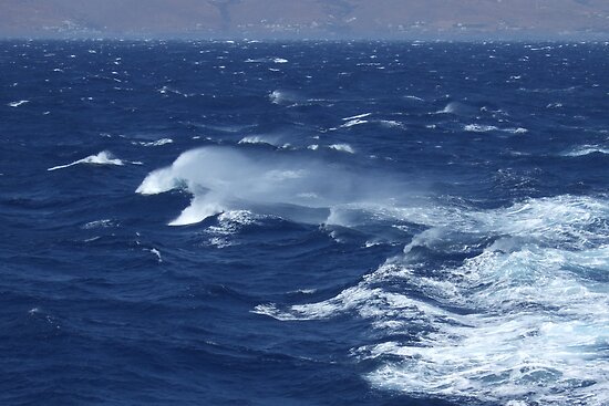
Locally rough and choppy seas…small to medium surf
World-wide tropical cyclone activity:
>>> Atlantic Ocean: The last regularly scheduled Tropical Weather Outlook of the 2015 Atlantic hurricane season…has occurred. Routine issuance of the Tropical Weather Outlook will resume on June 1, 2016. During the off-season, Special Tropical Weather Outlooks will be issued if conditions warrant. Here’s the 2015 hurricane season summary
Here’s a satellite image of the Atlantic Ocean
>>> Caribbean Sea: The last regularly scheduled Tropical Weather Outlook of the 2015 Atlantic hurricane season…has occurred. Routine issuance of the Tropical Weather Outlook will resume on June 1, 2016. During the off-season, Special Tropical Weather Outlooks will be issued if conditions warrant.
>>> Gulf of Mexico: The last regularly scheduled Tropical Weather Outlook of the 2015 Atlantic hurricane season…has occurred. Routine issuance of the Tropical Weather Outlook will resume on June 1, 2016. During the off-season, Special Tropical Weather Outlooks will be issued if conditions warrant.
Here’s a satellite image of the Caribbean Sea…and the Gulf of Mexico
Here’s the link to the National Hurricane Center (NHC)
>>> Eastern Pacific: The last regularly scheduled Tropical Weather Outlook of the 2015 North Pacific hurricane season…has occurred. Routine issuance of the Tropical Weather Outlook will resume on May 15, 2016. During the off-season, Special Tropical Weather Outlooks will be issued if conditions warrant. Here’s the 2015 hurricane season summary
Here’s a wide satellite image that covers the entire area between Mexico, out through the central Pacific…to the International Dateline.
Here’s the link to the National Hurricane Center (NHC)
>>> Central Pacific: The central north Pacific hurricane season has officially ended. Routine issuance of the tropical weather outlook will resume on June 1, 2016. During the off-season, special tropical weather outlooks will be issued if conditions warrant. Here’s the 2015 hurricane season summary
Here’s a link to the Central Pacific Hurricane Center (CPHC)
>>> South Pacific Ocean:
Tropical Cyclone 18P (Zena) is active in the southwest Pacific, here’s the JTWC graphical track map, a satellite image, and what the computer forecast models are showing of this strengthening storm.
>>> North and South Indian Oceans / Arabian Sea: No active tropical cyclones
Here’s a link to the Joint Typhoon Warning Center (JTWC)
Interesting: NASA examines El Nino’s impact on ocean’s food source – El Niño years can have a big impact on the littlest plants in the ocean, and NASA scientists are studying the relationship between the two.
In El Niño years, huge masses of warm water – equivalent to about half of the volume of the Mediterranean Sea – slosh east across the Pacific Ocean towards South America. While this warm water changes storm systems in the atmosphere, it also has an impact below the ocean’s surface. These impacts, which researchers can visualize with satellite data, can ripple up the food chain to fisheries and the livelihoods of fishermen.
El Niño’s mass of warm water puts a lid on the normal currents of cold, deep water that typically rise to the surface along the equator and off the coast of Chile and Peru, said Stephanie Uz, ocean scientist at Goddard Space Flight Center in Greenbelt, Maryland. In a process called upwelling, those cold waters normally bring up the nutrients that feed the tiny organisms, which form the base of the food chain.
“An El Niño basically stops the normal upwelling,” Uz said. “There’s a lot of starvation that happens to the marine food web.” These tiny plants, called phytoplankton, are fish food – without them, fish populations drop, and the fishing industries that many coastal regions depend on can collapse.
With NASA satellite data, and ocean color software called SeaDAS, developed at the Ocean Biology Processing Group at Goddard, Uz has been mapping where these important phytoplankton appear. Orbiting instruments like the Moderate Resolution Imaging Spectrometer on the Aqua satellite, and the Visible Infrared Imaging Radiometer Suite on the Suomi NPP satellite collect data on the color of the ocean. From shades of blue and green, scientists can calculate the amount of green chlorophyll – and therefore the amount of phytoplankton present.
The ocean color maps, based on a month’s worth of satellite data, can show that El Niño impact on phytoplankton. In December 2015, at the peak of the current El Niño event, there was more blue – and less green chlorophyll – in the Pacific Ocean off of Peru and Chile, compared to the previous year. Uz and her colleagues are also watching as the El Niño weakens this spring, to see when and where the phytoplankton reappear as the upwelling cold water brings nutrients back to the region.
“They can pop back up pretty quickly, once they have a source of nutrients,” Uz said.
Researchers can also examine the differences in ocean color between two different El Niño events. During the large 1997-1998 El Niño event, the green chlorophyll virtually disappeared from the coast of Chile. This year’s event, while it caused a drop in chlorophyll primarily along the equator, was much less severe for the coastal phytoplankton population. The reason – the warmer-than-normal waters associated with the two El Niño events were centered in different geographical locations. In 1997-1998, the biggest ocean temperature abnormalities were in the eastern Pacific Ocean; this year the focus was in the central ocean. This difference impacts where the phytoplankton can feed on nutrients, and where the fish can feed on phytoplankton.
“When you have an East Pacific El Niño, like 1997-1998, it has a much bigger impact on the fisheries off of South America,” Uz said. But Central Pacific El Niño events, like this year’s, still have an impact on ocean ecosystems, just with a shift in location. Researchers are noting reduced food available along the food chain around the Galapagos Islands, for example. And there has been a drop in phytoplankton off the coast of South America, just not as dramatically as before.
Scientists have more tools on hand to study this El Niño, and can study more elements of the event, Uz said. They’re putting these tools to use to ask questions not just about ocean ecology, but about the carbon cycle as well.
“We know how important phytoplankton are for the marine food web, and we’re trying to understand their role as a carbon pump,” Uz said. The carbon pump refers to one of the ways the Earth system removes carbon dioxide from the atmosphere. When phytoplankton die, their carbon-based bodies sink to the ocean floor, where they can remain for millions of years. El Niño is a naturally occurring disruption to the typical ocean currents, she said – so it’s important to understand the phenomenon to better attribute what occurs naturally, and what occurs due to human-caused disruptions to the system.
Other scientists at Goddard are investigating ways to forecast the ebbs and flows of nutrients using the center’s supercomputers, incorporating data like winds, sea surface temperatures, air pressures and more.
“It’s like weather forecasts, but for bionutrients and phytoplankton in the ocean,” said Cecile Rousseaux, an ocean modeler with Goddard’s Global Modeling and Assimilation Office. The forecasts could help fisheries managers estimate how good the catch could be in a particular year, she said, since fish populations depend on phytoplankton populations. The 1997-1998 El Niño led to a major collapse in the anchovy fishery off of Chile, which caused economic hardships for fishermen along the coast.
So far, Rousseaux said, the phytoplankton forecast models haven’t shown any collapses for the 2015-2016 El Niño, possibly because the warm water isn’t reaching as far east in the Pacific this time around. The forecast of phytoplankton populations effort is a relatively new effort, she said, so it’s too soon to make definite forecasts. But the data so far, from the modeling group and others, show conditions returning to a more normal state this spring.
The next step for the model, she said, is to try to determine which individual species of phytoplankton will bloom where, based on nutrient amounts, temperatures and other factors – using satellites and other tools to determine which kind of microscopic plant is where.
“We rely on satellite data, but this will go one step further and give us even more information,” Rousseaux said.
Teresa Says:
Thanks, Glenn. Good point on the light winds. We’ll take note of that.
We will be skipping that early morning start to enjoy a nice Maui style breakfast first and a then a slightly warmer ride down through Kula and into Haiku.
Mahalo nui loa, otra vez!
teresa
~~~ Hi Teresa, that sounds like a good idea, have fun!
Aloha, Glenn
Teresa Says:
Aloha Glenn,
What a wonderful site! I saw a link on TripAdvisor and can’t believe I’ve not caught on to this site before.
Here’s my question and it’s very specific to your home island, Maui: what weather pattern creates the rare, totally clear, crystalline days on Maui…or…ok, at least a day where the clouds don’tdevelop until the afternoon?
I’ll be back in Maui 2 wks from today and my hubs and I want to take a leisurely, dry and CLEAR morning bike ride down HaleAkala. Without experiencing the Haiku rain blessing. We are fortunate to spending a lot of time on Maui, so we can afford to be particular about the day we choose.
It will be SUPER helpful to know what weather pattern sets these days up – a stationary high, maybe? Because they are few and far between!
Mahalo nui loa,
teresa
~~~ Hi Teresa, glad you found my website…thanks for your positive comment!
Nice to hear that you’re coming to Maui, I’m sure you’ll be fine…and will greatly enjoy your time on our lovely island.
As for a totally clear morning up on the slopes of the Haleakala Crater, and then down into Paia town. Often, even very often, the day starts off very clear and cool just below the 7,000 foot level…where you’ll start your ride down on the bikes.
It’s very difficult to forecast what exactly will be happening from day to day up there. However, with that said, you may want to use this link: http://www.hawaiiweathertoday.com/maui.php?zone=HIZ022
as a guide.
Although this may help to: http://www.hawaiiweathertoday.com/maui.php?zone=HIZ020
Probably the best guide, might be to know that the lighter the winds during the days, the more likely it will be clear in the early morning hours. When stronger trade winds are blowing, they can carry showers into the area where you’ll start your ride, and can be a part of your ride all the way down to Paia.
Good question, not a simple answer I’m afraid.
Best of luck!
Aloha, Glenn
Kevin Says:
Thank you for the link and your thoughts! We will be staying in Kapaa, but figure a drive towards Poipu may increase our chances for sunshine. Aloha!
~~~ You’re very welcome Kevin, again…have a grand time!
Aloha, Glenn
Kevin Says:
Hello Glenn! I have been following this site for a few years, and wanted to say thank you for all of your insight and information. We are headed to Kauai tomorrow for a week and are excited to be back in the islands! It’s looking quite cloudy for a while, do you see some opportunity for sun in the next week? Thanks again for all you do!
~~~ Hi Kevin, you are very welcome, I greatly enjoy following the weather here in the islands…and sharing it with you and all the others!
I don’t know which part of Kauai you’ll be on, so it’s tough to give you a very good answer. However, I’d say that there will be off and on cloudy periods, mixed with sunshine during the days at times too…along with showers periodically as well.
You will be able to drive to sunshine, at least probably…at least out of the most frequent showers. I assume you are using my forecasts for Kauai, just click on the area you will be staying in.
http://www.hawaiiweathertoday.com/kauai.php
Have a great vacation!
Aloha, Glenn