


Air Temperatures – The following maximum temperatures (F) were recorded across the state of Hawaii Thursday…along with the minimums Thursday:
81 – 66 Lihue, Kauai
81 – 68 Honolulu, Oahu
83 – 64 Molokai AP
87 – 64 Kahului AP, Maui
80 – 62 Kailua Kona
85 – 66 Hilo AP, Hawaii
Here are the latest 24-hour precipitation totals (inches) for each of the islands, as of Thursday evening:
0.12 Mount Waialeale, Kauai
0.89 Poamoho, Oahu
0.05 Molokai
0.00 Lanai
0.33 Kahoolawe
0.31 Kula Branch Station, Maui
0.45 Kahua Ranch, Big Island
The following numbers represent the strongest wind gusts (mph)…as of Thursday evening:
18 Moloaa Dairy, Kauai – SE
15 Oahu Forest NWR, Oahu – NE
13 Molokai – ESE
13 Lanai – SW
12 Kahaloowe – SW
13 Hana, Maui – ESE
18 Upolu AP, Big Island – NE
Hawaii’s Mountains – Here’s a link to the live web cam on the summit of near 13,800 foot Mauna Kea on the Big Island of Hawaii. This web cam is available during the daylight hours here in the islands…and when there’s a big moon shining down during the night at times. Plus, during the nights you will be able to see stars, and the sunrise and sunset too…depending upon weather conditions.
Aloha Paragraphs

The early spring storm track remains well north of Hawaii,
with a large swath of tropical moisture moving northeast…
far to the east of the islands

An area of low pressure is evident to our north and west…about
to bring us some heavy rains as it moves east

Mostly clear to partly cloudy…with increasing clouds moving over
Kauai heading eastward – with embedded thunderstorms

Showers falling locally over islands…some locally heavy
looping radar image
(Kauai Radar is out of service)
Flash Flood Warning…the entire island of Kauai – until 715am
~~~ Hawaii Weather Narrative ~~~
Light south to southeast winds prevail…keeping volcanic haze in our area. Here’s the latest weather map, showing the Hawaiian Islands, and the rest of the North Pacific Ocean. We find high pressure systems far to the northeast and northwest of Hawaii. At the same time, we see a low pressure system to the northwest…with an associated trough of low pressure over the ocean to the west-northwest of the islands. Our local winds are generally light southeast, and this wind direction continues to carry thick volcanic haze over us. The latest forecast has light winds continuing through the weekend, and then turning southwest ahead of a cold front Monday into Tuesday. We’ll likely see relatively cool northerly breezes arriving towards the middle of next week…in the wake of the cold front. It looks as though we may return to light to moderately strong trade winds during the later part of next week.
There will be localized showers, with thunderstorms near Kauai tonight…which becomes more pronounced statewide as we move into Friday and Saturday. This is due to a nearby area of low pressure just to our west-northwest, which is keeping our local atmosphere shower prone. This low pressure trough will be moving eastward, first over Kauai tonight…bringing unsettled weather as it moves across the state into Saturday. We’ll see the good chance of heavy showers, and potentially a few severe thunderstorms (hail and strong winds) into Saturday. There’s a decent chance that Sunday may become drier and more favorably inclined weatherwise, at least briefly. As we move into early next week, we’ll find the next cold front approaching. This frontal boundary will bring a period of showers to the island chain later Monday into early Wednesday morning. The longer range outlook shows relatively dry weather returning during the middle to later part of next week.

Marine environment details: There are no marine warnings in effect. Waters around Hawaii are expected to remain below advisory thresholds through Monday, with only a small north-northwest swell peaking tonight followed by a small northwest swell this weekend. Surf will remain below advisory levels and winds are expected to remain light. Small background south swells will continue through the period along our leeward beaches. A very large northwest swell is forecast to arrive Tuesday and peak late Tuesday night, possibly bringing warning level surf to north and west facing shores.
Thunderstorms will remain possible, continuing through Saturday, as a trough of low pressure slowly tracks eastward across the island chain.
Here’s a wind profile…of the offshore waters around the islands – with a closer view
Here’s the Hawaiian Islands Sulfate Aerosol…animated graphic – showing vog forecast
Here in Maui County…It’s mostly clear early this Thursday morning. I can still see major volcanic haze in our environment before sunrise. Here in upcountry Kula, it was mostly clear and calm, with the air temperature 50.7F degrees. The temperature at near the same time was 65 degrees down in Kahului under clear skies, 68 out in Hana with clear skies, and 39 atop the Haleakala summit. Meanwhile, Kahoolawe was 73 degrees, 62 at Lanai City under clear skies, with 66 at the Molokai airport…also with clear skies. / Now at 1130am, clouds have quickly gathered over the islands of Maui County, especially over the West Maui Mountains and the Haleakala Crater. These clouds are looking and feeling very similar to yesterday’s, which you may know dropped locally heavy rains in the upcountry regions.
– Early afternoon, with clouds extensive over and around the mountains, with still muted sunshine down closer to the coasts. The volcanic haze remains in place…and is about as thick as it gets! / Now at 135pm, at least here in upcountry Kula, the first rather large rain drops have arrived. / Now at 405pm, it’s totally cloudy, with a bit of fog, and off and on heavy rains for the last hour or so here in upcountry Kula. Interestingly enough, when the clouds lift a little, I’ve seen sunny skies prevailing down in the lower elevations and along the beaches.
– As noted above, it rained off and on again this afternoon, at least across the upcountry slopes of Haleakala, and I’m sure the West Maui Mountains. Now at 555pm, the showers seem to be winding down, although from my vantage point here in Kula, I see clouds in all directions. The atmosphere remains very voggy too, with no end in sight to this volcanic haze, at least not through Friday. These early evening clouds will evaporate rather quickly, likely paving the way into a clear start to our day on Friday. This of course will not be the case for the Kauai side of the state, as a trough of low pressure moves overhead.
World-wide tropical cyclone activity:
>>> Atlantic Ocean: The last regularly scheduled Tropical Weather Outlook of the 2015 Atlantic hurricane season…has occurred. Routine issuance of the Tropical Weather Outlook will resume on June 1, 2016. During the off-season, Special Tropical Weather Outlooks will be issued if conditions warrant. Here’s the 2015 hurricane season summary
Here’s a satellite image of the Atlantic Ocean
>>> Caribbean Sea: The last regularly scheduled Tropical Weather Outlook of the 2015 Atlantic hurricane season…has occurred. Routine issuance of the Tropical Weather Outlook will resume on June 1, 2016. During the off-season, Special Tropical Weather Outlooks will be issued if conditions warrant.
>>> Gulf of Mexico: The last regularly scheduled Tropical Weather Outlook of the 2015 Atlantic hurricane season…has occurred. Routine issuance of the Tropical Weather Outlook will resume on June 1, 2016. During the off-season, Special Tropical Weather Outlooks will be issued if conditions warrant.
Here’s a satellite image of the Caribbean Sea…and the Gulf of Mexico
Here’s the link to the National Hurricane Center (NHC)
>>> Eastern Pacific: The last regularly scheduled Tropical Weather Outlook of the 2015 North Pacific hurricane season…has occurred. Routine issuance of the Tropical Weather Outlook will resume on May 15, 2016. During the off-season, Special Tropical Weather Outlooks will be issued if conditions warrant. Here’s the 2015 hurricane season summary
Here’s a wide satellite image that covers the entire area between Mexico, out through the central Pacific…to the International Dateline.
Here’s the link to the National Hurricane Center (NHC)
>>> Central Pacific: The central north Pacific hurricane season has officially ended. Routine issuance of the tropical weather outlook will resume on June 1, 2016. During the off-season, special tropical weather outlooks will be issued if conditions warrant. Here’s the 2015 hurricane season summary
Here’s a link to the Central Pacific Hurricane Center (CPHC)
>>> South Pacific Ocean: No active tropical cyclones
>>> North and South Indian Oceans / Arabian Sea: No active tropical cyclones
Here’s a link to the Joint Typhoon Warning Center (JTWC)
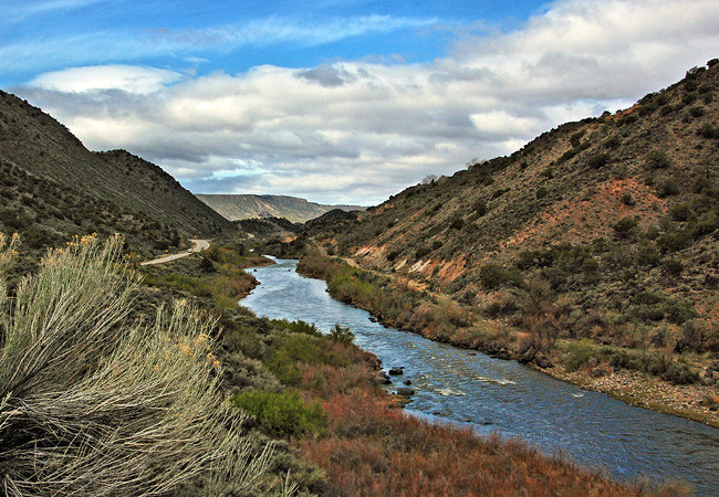
Interesting: New research on the Rio Grande and impacts of long drought – New research can help water managers along the Rio Grande make wise decisions about how to best use the flow of a river vital for drinking water, agriculture and aquatic habitat. These studies also show how conditions from the prolonged drought in the West have affected the Rio Grande watershed.
The Rio Grande forms the world’s longest river border between two countries as it flows between Texas and Mexico, where it is known as the Rio Bravo. The river runs through three states in the U.S., beginning in southern Colorado and flowing through New Mexico and Texas before it forms the border with Mexico.
Parts of the Rio Grande are designated as wild and scenic, but most of the river is controlled and passes through several dam and reservoir systems during its 1,896 mile journey to the Gulf of Mexico. The river is managed through a complex system of compacts, treaties, and agreements that determine when and how much water is released along the river’s length.
The amount and timing of water releases have varied in recent years due to drought. Recent USGS research on the middle Rio Grande looked at the effects of those changes on the amount of salts that build up in the Rincon and Mesilla Valleys in Texas and New Mexico. Results showed a decline in the amount of salt carried by the river due to a decrease of releases during the drought. The two valleys responded differently to the decreased releases. Salt levels in the Rincon Valley declined, whereas salt levels in the Mesilla Valley increased. Salt buildup in the soil and water can affect agriculture, which is an important industry in those valleys.
Successfully managing water use along the river is important to the sustainability of agricultural and communities along the river. To help with that goal, USGS has measured water gains and losses to the Rio Grande from between the Leasburg Dam near Leasburg, New Mexico, and the American Dam near El Paso, Texas. American Dam is near where the Rio Grande becomes the border with Mexico. For the past several years, drought conditions contributed to decreasing flows along this 64-mile stretch, and sections of the river were dry during parts of the year.
Flow in the Rio Grande is affected by how water is used throughout the basin. For instance, the Albuquerque area of New Mexico has two principal sources of water: groundwater from the underlying aquifer system and withdrawals and diversions from the Rio Grande. From 1960 to 2002, pumping from the aquifer system caused groundwater levels to decline from about 40 feet along the Rio Grande in Albuquerque to more than 120 feet in the valley away from the river. As a result, the USGS, in cooperation with the Bureau of Reclamation, conducted a study to understand the exchange of water between the Rio Grande and the aquifer system.
By characterizing the interaction between surface water from the Rio Grande and groundwater from the aquifer system, scientists provide valuable information to help managers make informed decisions about water use.