


Air Temperatures – The following maximum temperatures (F) were recorded across the state of Hawaii Sunday…along with the minimum temperatures Sunday:
79 – 64 Lihue, Kauai
83 – 68 Honolulu, Oahu
77 – 64 Molokai AP
75 – 69 Kahului, Maui
82 – 70 Kailua Kona
84 – 70 Hilo, Hawaii
Here are the latest 24-hour precipitation totals (inches) for each of the islands, as of Sunday evening:
0.01 Mount Waialeale, Kauai
0.02 Waimanalo, Oahu
0.09 Molokai
0.00 Lanai
0.01 Kahoolawe
3.95 Kahakuloa, Maui
0.97 Kealakomo, Big Island
The following numbers represent the strongest wind gusts (mph)…as of Sunday evening:
23 Port Allen, Kauai – SE
21 Kii, Oahu – SE
15 Molokai – SE
20 Lanai – NE
22 Kahoolawe – N
13 Hana, Maui – NE
18 South Point, Big Island – NE
Hawaii’s Mountains – Here’s a link to the live web cam on the summit of near 13,800 foot Mauna Kea on the Big Island of Hawaii. This web cam is available during the daylight hours here in the islands…and when there’s a big moon shining down during the night at times. Plus, during the nights you will be able to see stars, and the sunrise and sunset too… depending upon weather conditions.
Aloha Paragraphs

A large area of clouds to the northwest, north
through northeast
Lots of clouds to our north…clear across the state…
at the time of this writing

Very few showers in our vicinity
~~~ Hawaii Weather Narrative ~~~
Wind Advisory…for strong and gusty southwest to westerly
winds across our area, including the summits of the mountains
Small Craft Advisory…for large northwest swell and combined
seas at hazardous levels
Light trade winds, veering to the southwest and becoming much stronger locally by Tuesday…as a cold front approaches our area. Here’s the latest weather map, showing the Hawaiian Islands, and the rest of the North Pacific Ocean, along with a real-time wind profiler of the central Pacific. We find high pressure systems to the northeast and northwest of the state, with ridges of high pressure over the ocean nearby. At the same time, we have a large and impressive gale low pressure system to the north, with the tail-end of a weak cold front over the eastern islands. Light trade winds will persist into Monday, before our winds veer and strengthen significantly from the west and southwest…as we see a cold front moving towards and then over the state into Tuesday. Unusual westerly winds will prevail much of the upcoming work week, and will likely become strong and gusty at times…bringing cold fronts our way periodically. The latest model runs show better weather arriving next weekend, although then yet another cold front is expected a week from Monday.
Localized showers today, then increasing clouds and rain Monday night into Tuesday. Here’s the looping radar image showing showers falling, especially over parts of Maui County and the Big Island. As the trade winds continue into Monday morning, whatever showers that are around, will fall along our windward sides, with a few over the upcountry areas. The next cold front will spread more widespread showers across the state starting late Monday into Tuesday. Thereafter, the prevailing westerly winds, which are typically located well north of the Hawaiian Islands, will dip down over our tropical latitudes. This will keep off and on unsettled weather in place through Friday, with cold frontal passages at times. There are likely to be more changes in the new week’s weather outlook…stay tuned for additional updates. I’ll be back with more information on all of the above, I hope you have a great Sunday night wherever you’re spending it! Aloha for now…Glenn.
Here in Kula, Maui: It’s mostly cloudy and foggy on this Sunday morning, with light rain falling. The air temperature near its minimal reading this morning was 58 degrees. ~~~ It’s now 1115am, with a cool breeze blowing over my weather tower, which is carrying light mist and drizzle. Skies have just cleared enough that I can look down the mountain, and I see that there are lots of low clouds around, many of which have been dropping rainfall here on Maui. Interestingly enough, the windward side of Maui is the wettest area in the state. The brisk winds are blowing those showers over into the leeward sides at times too. ~~~ 1235pm and its still lightly raining, along with pea soup fog, some of my favorite weather conditions…temperature a cool 64.6 degrees. ~~~ It’s now later in the afternoon at 255pm, under still thick fog, and light mist, with a cool 63.3 degrees on the thermometer. ~~~ 405pm, still foggy and cool, with very light mist…air temperature 62.8 degrees. I’m watching the Super Bowl on the internet this afternoon, I like it, although the advertisements are so numerous…and repetitive! ~~~ We’re into the early evening hours now, and the clouds have finally begun to clear, with the sun out a little. Now that I can see what’s going on, I can report that we still have lots of volcanic haze in our atmosphere…moderate to thick stuff. I was just now able to step out on my weather deck and to look towards the east…I can see a big almost full moon rising, it’s nice to see after being closed in by the clouds and fog all day!
~~~ Weekend youtube video, Honolulu City Lights…by Keola and Kapono Beamer
Friday Evening Film: My neighbor Jeff and I will see a film that we’ve been looking forward to for quite a while. We figured that after its been out for three weeks, that perhaps the crowds will have thinned out by now. This film is called American Sniper, starring Bradley Cooper, Sienna Miller, Luke Grimes, Kyle Gallner, Elise Robertson, and Ben Reed...among many others. The synopsis: From director Clint Eastwood comes “American Sniper,” starring Bradley Cooper as Chris Kyle, the most lethal sniper in U.S. military history. But there was much more to this true American hero than his skill with a rifle. U.S. Navy SEAL sniper Chris Kyle is sent to Iraq with only one mission: to protect his brothers-in-arms. His pinpoint accuracy saves countless lives on the battlefield and, as stories of his courageous exploits spread, he earns the nickname “Legend.” However, his reputation is also growing behind enemy lines, putting a price on his head and making him a prime target of insurgents. Despite the danger, as well as the toll on his family at home, Chris serves through four harrowing tours of duty in Iraq, becoming emblematic of the SEAL creed to “leave no man behind.” But upon returning home, Chris finds that it is the war he can’t leave behind.
I thought, we thought, this was a very good film, which as we figured going in…was going to be a gripping exposure to men at war! It certainly wasn’t an easy film to sit through, although I was glad to have seen this riveting piece of work in the end. Bradley Cooper played an exceptionally good role, being pushed into a foggy disorientation while at home with his family, and then waking up impressively when back in the fight. The transition periods during his incredible four tours of duty, is what made the story so interesting. As one critic put it, “American Sniper is pro-warrior, not pro-war.” This war damaged the main character, although it didn’t keep him from being very smart when he needed to be. The battle scenes were very realistic, bringing many scenes right to the pit of your stomach. The theater showed this film in the largest space it had, and the hundreds of people attending filled almost every seat. It was interesting, as all of these folks stood up and filed out, you could have heard a pin drop. There wasn’t the usual noise of people talking, as I think everyone found themselves still too deep inside for small talk. Our little group went out for a drink after the film, to try and calm our nerves a little…as we all found ourselves a little shell shocked. This film isn’t for everyone, although it was totally engaging, and in a sort of strange way, very entertaining! As for grades, everyone I was with, and there were four of us, all gave it a B+ grade. Here’s the trailer if you’d like to take a peek…it’s intense.
World-wide tropical cyclone activity:
>>> Atlantic Ocean: The last regularly scheduled Tropical Weather Outlook of the 2014 Atlantic hurricane season…has occurred. Routine issuance of the Tropical Weather Outlook will resume on June 1, 2015. During the off-season, Special Tropical Weather Outlooks will be issued as conditions warrant.
Here’s a satellite image of the Atlantic Ocean
>>> Caribbean Sea: The last regularly scheduled Tropical Weather Outlook of the 2014 Atlantic hurricane season…has occurred. Routine issuance of the Tropical Weather Outlook will resume on June 1, 2015. During the off-season, Special Tropical Weather Outlooks will be issued as conditions warrant.
>>> Gulf of Mexico: The last regularly scheduled Tropical Weather Outlook of the 2014 Atlantic hurricane season…has occurred. Routine issuance of the Tropical Weather Outlook will resume on June 1, 2015. During the off-season, Special Tropical Weather Outlooks will be issued as conditions warrant.
Here’s a satellite image of the Caribbean Sea…and the Gulf of Mexico.
>>> Eastern Pacific: The last regularly scheduled Tropical Weather Outlook of the 2014 North Pacific hurricane season…has occurred. Routine issuance of the Tropical Weather Outlook will resume on May 15, 2015. During the off-season, Special Tropical Weather Outlooks will be issued as conditions warrant.
Here’s a wide satellite image that covers the entire area between Mexico, out through the central Pacific…to the International Dateline.
Here’s the link to the National Hurricane Center (NHC)
>>> Central Pacific: The central north Pacific hurricane season has officially ended. Routine issuance of the tropical weather outlook will resume on June 1, 2015. During the off-season, special tropical weather outlooks will be issued as conditions warrant.
Here’s a link to the Central Pacific Hurricane Center (CPHC)
>>> Northwest Pacific Ocean: There are no active tropical cyclones
>>> South Pacific Ocean: Tropical cyclone 10P (Ola) remains active, here’s the JTWC graphical track map for this soon to be weakening tropical cyclone. Here’s the NOAA satellite image of this system…to the west-southwest of New Caledonia.
>>> North and South Indian Oceans: Tropical cyclone 09S (Eunice) is dissipating, here’s the JTWC graphical track map for this retiring tropical cyclone. Here’s the NOAA satellite image of this system…to the southwest of Cocos Island in the South Indian Ocean. – Final Warning
Here’s a link to the Joint Typhoon Warning Center (JTWC)
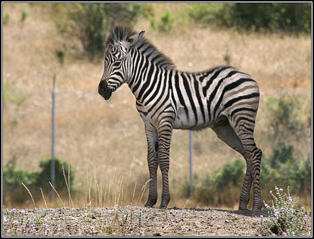
Interesting: How did the Zebra get its stripes? – One of nature’s fascinating questions is how zebras got their stripes.
Larison has found at least part of the answer: The amount and intensity of striping can be best predicted by the temperature of the environment in which zebras live.
In the January cover story of the Royal Society’s online journal, Open Science, the researchers make the case that the association between striping and temperature likely points to multiple benefits — including controlling zebras’ body temperature and protecting them from diseases carried by biting flies.
“While past studies have typically focused their search for single mechanisms, we illustrate in this study how the cause of this extraordinary phenomenon is actually likely much more complex than previously appreciated, with temperature playing an important role,” said Thomas B. Smith, professor of ecology and evolutionary biology in the UCLA College and senior author of the research.
Larison, a researcher in UCLA’s department of ecology and evolutionary biology and the study’s lead author, and her colleagues examined the plains zebra, which is the most common of three zebra species and has a wide variety of stripe patterns. On zebras in warmer climes, the stripes are bold and cover the entire body. On others — particularly those in regions with colder winters such as South Africa and Namibia — the stripes are fewer in number and are lighter and narrower. In some cases, the legs or other body parts have virtually no striping.
Zebras evolved from horses more than 2 million years ago, biologists have found. Scientists have previously hypothesized that zebras’ stripes evolved for one, or a combination of, four main reasons: confusing predators, protecting against disease-carrying insects, controlling body temperature and social cohesion. And while numerous previous studies of the phenomenon focused on a single hypothesis, the Larison-led study was the first to fully test a large set of hypotheses against one another.
mary Says:
Have had rain here in Kihei since 6:30AM. A nice slow drizzle.~~~ Hi Mary, we’ve had that up here in Kula too. It’s foggy and cool here, I’m sure it is warmer down there…although certainly not a banner day for sunshine! Thanks for the report, Aloha, Glenn
Anurag Says:
i’d like to watch the almost full moon going down into the ocean on monday morning at 6.07 am, if possible. guessing honolua bay may be a good place to see it from, weather permitting. what do you reckon, glen?~~~Hi Anurag, that’s of course a valid question, although I’m hesitant to give a definitive answer. The reason: I honestly don’t know, and don’t want you to have to take that long drive for cloudy and showery weather conditions…without being able to see the moon sinking into the pacific to our west. Aloha, Glenn