


Air Temperatures – The following maximum temperatures were recorded across the state of Hawaii Thursday afternoon:
Lihue, Kauai – 78
Honolulu airport, Oahu – 82
Molokai airport – 83
Kahului airport, Maui – 82
Kona airport – 82
Hilo airport, Hawaii – 76
Air Temperatures ranged between these warmest and coolest spots near sea level – and on the highest mountain tops around the state…as of 815pm Thursday evening:
Kailua Kona – 76
Hilo, Hawaii – 68
Haleakala Summit – 43 (near 10,000 feet on Maui)
Mauna Kea Summit – M (near 13,800 feet on the Big Island)
Hawaii’s Mountains – Here’s a link to the live web cam on the summit of near 13,800 foot Mauna Kea on the Big Island of Hawaii. This web cam is available during the daylight hours here in the islands…and when there’s a big moon shining down during the night at times. Plus, during the nights you will be able to see stars, and the sunrise and sunset too…depending upon weather conditions. Here's the Haleakala Crater webcam on Maui.
Tropical Cyclone activity in the eastern and central Pacific – Here’s the latest weather information coming out of the National Hurricane Center, covering the eastern north Pacific. You can find the latest tropical cyclone information for the central north Pacific (where Hawaii is located) by clicking on this link to the Central Pacific Hurricane Center. A satellite image, which shows the entire ocean area between Hawaii and the Mexican coast…can be found here. The 2012 hurricane season is over in the eastern and central Pacific…resuming on May 15th and June 1st 2013.
Aloha Paragraphs
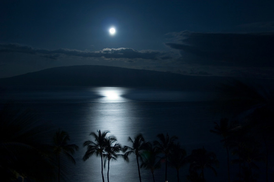
Photo credit…Bob Ewing
Sunny to partly cloudy, cloudy afternoons in the
upcountry areas today…a few limited showers
Our local winds becoming lighter from the
southeast later Friday into the weekend
Wind advisory over the Big Island summits
High surf warning north facing shores of Niihau, Kauai,
Oahu, Molokai and Maui – west facing shores of Niihau
and Kauai
High surf advisory for west shores of Oahu and Molokai
Small Craft advisory in effect until 6pm HST this evening
The air temperature at 535am HST Friday morning, at my
upcountry Kula, Maui weather tower: 49.3F degrees
The following numbers represent the most recent top wind gusts (mph), along with directions as of Thursday evening:
24 Port Allen, Kauai – E
31 Kahuku Trng, Oahu – SE
28 Molokai – ENE
36 Kahoolawe – NE
21 Lipoa, Maui – E
M Lanai – NE
29 Upolu airport, Big Island – ENE
Here are the latest 24-hour precipitation totals (inches) for each of the islands as of Thursday evening:
0.35 Mount Waialeale, Kauai
0.09 Poamoho RG 1, Oahu
0.00 Molokai
0.00 Kahoolawe
0.00 Maui
0.77 Waiakea Uka, Big Island
We can use the following links to see what’s going on in our area of the north central Pacific Ocean. Here's the latest NOAA satellite picture – the latest looping satellite image…and finally the latest looping radar image for the Hawaiian Islands.
~~~ Hawaii Weather Commentary ~~~
Our winds will remain active from the trade wind direction, although ease up and turn more southeasterly Friday morning…into the weekend. Here's a weather chart showing high pressure centers to our north-northeast and northeast. At the same time, we find a weak, near 1010 millibar low pressure system over the ocean to our west…with a cold front extending from its center to another low pressure cell offshore from the Washington coast. Our local winds were quite strong at times Thursday, gusting up into the 30+ mph range in those windiest spots. Winds will become lighter during the day Friday, shifting to the southeast into the weekend, ahead of an approaching weak cold front. I'd expect to see the return of volcanic haze (vog) as these southeast breezes arrive.
Generally fine weather, with just a few showers…will prevail through Sunday. Here's a satellite image, showing fairly clear skies in most areas of the state, with some higher and brighter clouds located to our east. As the winds become lighter Friday into the weekend, there will be afternoon clouds developing over and around the mountains, with a few showers here and there. This light wind regime, called a convective weather pattern, with its daytime sea breezes, and offshore flowing land breezes at night. This weather pattern will exist Saturday and Sunday, prompting cool early morning temperatures, so have that extra blanket ready for the bed then.
As for that weak cold front, it may bring showers our way later Monday into Tuesday over some parts of the state. The computer models vary, bringing the front only to Kauai…with others showing it reaching Maui County, we'll see. Chilly, and blustery north-northeast breezes will fill in behind the frontal passage by New Years Day, and then gradually warm up into the middle of next week, for several days thereafter. I'll be back early Friday morning with your next new weather narrative. By the way, don't forget to check out that last full moon of 2012 tonight! I hope you have a great Thursday night wherever you're viewing it. Aloha for now…Glenn.
Extra: Neil Young…Harvest Moon – Full screen suggested
Extra: Van Morrison...Moondance
World-wide tropical cyclone activity:
Atlantic Ocean/Caribbean Sea: There are no active tropical cyclones
Gulf of Mexico: There are no active tropical cyclones
Eastern Pacific Ocean: There are no active tropical cyclones
Central Pacific Ocean: There are no active tropical cyclones
Western Pacific Ocean: Tropical depression Wukong (27W) has been given its second final warning, and is dissipating in the South China Sea, located approximately 230 NM miles southeast of Ho Chi Minh City, Vietnam. Sustained winds are 25 knots, with gusts to near 35 knots. This dissipating tropical cyclone will continue to move across the South China Sea for a short time more…where it will dissipate soon. Here's the Joint Typhoon Warning Center (JTWC) graphical track map, along with a satellite image. Final Warning
South Pacific Ocean: Tropical cyclone 05P has spun up in the southwest Pacific…located approximately 75 south-southeast of Honiara, in the Soloman Islands. Sustained winds were 35 knots, with gusts to near 45 knots. This tropical cyclone will increase in strength, becoming a cyclone with 65 knot winds within 36 hours. Here's the JTWC graphical track map, along with a satellite image.
North and South Indian Oceans: There are no active tropical cyclones
Interesting: A hundred years ago we thought that we had to fill in the marshes near populated areas along the eastern US coastline since they represented prime locations for commercial and residential development. Even after some protections were put in place to reduce the impacts of runaway development, marshes continued to serve are the places we dumped our garbage, and sent the effluents from our waste water treatment plants.
They also receive the nutrient-rich run off from agricultural land use and urban street runoff to our rivers. A major nine-year study led by researcher Linda Deegan points to the damage that human-caused nutrients inflict on salt marshes along the U.S. East Coast. In a Yale Environment 360 interview, she describes what these findings mean for an ecosystem that provides critical services, from nourishing marine life to buffering the coast from storms like Sandy.
For centuries now, the salt marshes along the U.S. coast have been disappearing, with some experts estimating that 70 percent have been lost, largely due to development. While in recent decades the U.S. has done a better job of protecting these ecosystems, even marshes spared from development are now succumbing to more subtle threats, from rising sea levels to invasive species.
One factor scientists always thought marshes could withstand was nutrient enrichment, such as the flow of nitrogen and phosphorus from fertilizers and septic systems. But that might not be so, warns Linda Deegan, a senior scientist at the Marine Biological Laboratory in Woods Hole, Mass., and lead researcher of a long-term study showing that an overabundance of nutrients may be contributing to the demise of salt marshes.
During the nine-year study, in which Deegan's team added nutrients to a Massachusetts estuary, the researchers found that a burst of growth eventually caused the salt marsh plants to collapse onto themselves, converting healthy systems into mud flats.
In an interview with Yale Environment 360 Web editor Kevin Dennehy, Deegan describes the implications of this study, the vital services lost when marshes disappear — from nourishing marine species to providing a physical barrier for coastal communities during storms such as Hurricane Sandy — and what it will take to prevent further marshland loss.
"What Sandy brought home is that trying to draw a line and say, 'From here on back is human lands, and from here forward is the natural system,' isn’t going to work," Deegan said.
Brent Says:
Glenn,
Quick question, how come you don't post the current temperature up in Kula like you used to in your commentary.~~~Hi Brent, I could begin doing that again…it’s 51.3F here at 805am HST Thursday. Aloha, Glenn