


Air Temperatures – The following maximum temperatures were recorded across the state of Hawaii Wednesday afternoon:
Lihue, Kauai – 85
Honolulu airport, Oahu – 87
Kaneohe, Oahu – M
Molokai airport – 84
Kahului airport, Maui – 87
Kona airport – 86
Hilo airport, Hawaii – 82
Air Temperatures ranged between these warmest and coolest spots near sea level – and on the highest mountain tops around the state…as of 8pm Wednesday evening:
Barking Sands, Kauai – 81
Hilo, Hawaii – 76
Haleakala Summit – 48 (near 10,000 feet on Maui)
Mauna Kea Summit – 32 (near 13,800 feet on the Big Island)
Hawaii’s Mountains – Here’s a link to the live web cam on the summit of near 13,800 foot Mauna Kea on the Big Island of Hawaii. This web cam is available during the daylight hours here in the islands…and when there’s a big moon shining down during the night at times. Plus, during the nights you will be able to see stars, and the sunrise and sunset too…depending upon weather conditions. Here's the Haleakala Crater webcam on Maui…although this webcam is not always working correctly.
Tropical Cyclone activity in the eastern and central Pacific – Here’s the latest weather information coming out of the National Hurricane Center, covering the eastern north Pacific. You can find the latest tropical cyclone information for the central north Pacific (where Hawaii is located) by clicking on this link to the Central Pacific Hurricane Center. A satellite image, which shows the entire ocean area between Hawaii and the Mexican coast…can be found here.
Aloha Paragraphs

Trades becoming lighter…
generally fine weather
As this weather map shows, we have a moderately strong high pressure system located far to the northeast of the islands, with a weak cold front far to our north and northwest. Our local trade winds will remain moderately strong through the week.
The following numbers represent the most recent top wind gusts (mph), along with directions as of Wednesday evening:
32 Port Allen, Kauai – NE
35 Makua Ridge, Oahu – NE
33 Molokai – NE
39 Kahoolawe – NE
36 Kahului, Maui – NE
35 Lanai – NE
29 Kealakomo, Big Island – E
We can use the following links to see what’s going on in our area of the north central Pacific Ocean. Here's the latest NOAA satellite picture – the latest looping satellite image…and finally the latest looping radar image for the Hawaiian Islands.
Here are the latest 24-hour precipitation totals (inches) for each of the islands as of Wednesday evening:
0.03 Mount Waialeale, Kauai
0.04 Pupukea Road, Oahu
0.01 Molokai
0.00 Lanai
0.00 Kahoolawe
0.32 Puu Kukui, Maui
1.38 Kawainui Stream, Big Island
Sunset Commentary:
A relatively stable and dry atmosphere overlies the Hawaiian Islands now, with moderate trade winds continuing through the rest of this week…although with a subtle weakening of the winds too. We find a near 1028 millibar high pressure system (weather map) located to the northeast of the islands Wednesday afternoon…with an elongated high pressure ridge running from its center southwest…to the north and northwest of Kauai. These trades will carry a few windward showers towards us at times, somewhat less than normal into Friday. The leeward sides will be generally dry, although the leeward Kona slopes on the Big Island may see a few afternoon or early evening showers at times.
Here in Kula, Maui at 545pm Wednesday evening, it was partly cloudy and near calm…with an air temperature of 74.8F degrees. The trade winds will continue to blow across our islands through the next week and more. These trade winds will likely ease up a touch however, enough in fact, to allow the small craft wind advisories to likely expire Thursday or Friday into the weekend. If we look at this satellite image, we see low level cloud patches upstream of our islands, to the east and northeast. At the same time, we see a then area of high cirrus clouds to our southwest…with an area of thunderstorms far to our south-southeast of the Big Island. The computer models are now showing a modest uptick in windward biased showers starting this weekend, and lasting through next Tuesday or Wednesday. In sum: trade wind weather pattern is expected to continue, with local wind speeds easing up a touch starting Thursday, relatively dry now…with more showers starting this weekend. I'll be back early Thursday morning with your next new weather narrative, I hope you have a great Wednesday night wherever you happen to be spending it! Aloha for now…Glenn.
World-wide tropical cyclone activity:
Central Pacific Ocean: There are no active tropical cyclones
Eastern Pacific Ocean: Tropical depression Hector (8E) remains active over the waters offshore from Mexico…located about 445 miles west-southwest of the southern tip of Baja California…with sustained winds of 30 mph. Tropical depression Hector is forecast to become a remnant low pressure system by early Friday morning. Here's a NHC graphical track map. Here's the NHC satellite image showing tropical depression Hector.
Atlantic Ocean/Gulf of Mexico/Caribbean: Tropical storm Gordon (8L) is active in the Atlantic, located about 640 miles east of Bermuda. Sustained winds were 50 mph…with further strengthening expected…reaching hurricane status briefly in about 48 hours. Here's the NHC graphical track map for 8L.
The remnants of retired tropical depression 7L remains over southeastern Mexico…and the Yucatan Peninsula of Mexico. There's a low 10% chance that this area could regenerate into a tropical cyclone. Here's a satellite image of this remnant low. Gusty winds and heavy rains will continue over this area.
Here's a satellite image showing former 7L over parts of Mexico, and the Yucatan Peninsula…and tropical storm Gordon in the Atlantic.
Western Pacific Ocean: Typhoon Kai-tak (14W) is located approximately 155 NM south of Hong Kong, China. Sustained winds were 65 knots with gusts to near 80 knots…and still on a strengthening trend. The forecast track takes this storm across the South China Sea towards mainland China…making landfall well west of Hong Kong Friday. Here's a JTWC graphical track map.
South Pacific Ocean: There are no active tropical cyclones
North and South Indian Oceans: There are no active tropical cyclones
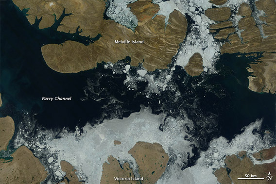
Interesting: A satellite image released by NASA last week shows a key channel that forms part of the Northwest Passage is partially free of ice. The image, acquired by the Moderate Resolution Imaging Spectroradiometer (MODIS) on NASA’s Terra satellite, shows that more than two-thirds of the Parry Channel was ice-free on July 30.
The median coverage for that date was 79 percent from 1980-2010. The Parry Channel separates Victoria Island from Melville Island in Canada's far north. Parry Channel is part of the northern route through the Northwest Passage. When navigable, the Northwest Passage offers a shortcut between the Atlantic and Pacific Oceans.
In recent years sea ice cover in the Arctic has declined substantially due to warming temperatures. Sea ice typically reaches its minimum extent in mid-September. Predictions range widely, but many experts expect the Arctic to be free of summer sea ice entirely within a few decades.
By almost all standards, sea ice is disappearing faster than expected, partly a consequence of a positive feedback loop triggered by retreating ice. Sea ice typically helps cool the Arctic by reflecting sunlight back into space. But when sea ice melts, the dark areas of open water absorb the sun's radiation, warming the region and worsening melting.