


Air Temperatures – The following maximum temperatures were recorded across the state of Hawaii Thursday:
Lihue, Kauai – 83
Honolulu airport, Oahu – 85 (Record high temperature for Thursday / 90 -1985, 1994, 1995)
Kaneohe, Oahu – 83
Molokai airport – 82
Kahului airport, Maui – 85 (Record high temperature for Thursday / 94 -1965, 1984)
Kona airport – 83
Hilo airport, Hawaii – 83
Air Temperatures ranged between these warmest and coolest spots near sea level – and on the highest mountain top around the state…as of 5pm Thursday evening:
Honolulu, Oahu – 85
Hilo, Hawaii – 80
Haleakala Summit – M (near 10,000 feet on Maui)
Mauna Kea Summit – 45 (near 13,800 feet on the Big Island)
Hawaii’s Mountains – Here’s a link to the live web cam on the summit of near 13,800 foot Mauna Kea on the Big Island of Hawaii. This web cam is available during the daylight hours here in the islands…and when there’s a big moon shining down during the night at times. Plus, during the nights you will be able to see stars, and the sunrise and sunset too…depending upon weather conditions. Here's the Haleakala Crater webcam on Maui…although this webcam is not always working correctly.
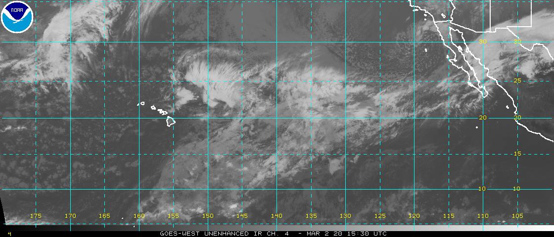
Tropical Cyclone activity in the eastern and central Pacific – Here’s the latest weather information coming out of the National Hurricane Center, covering the eastern north Pacific. You can find the latest tropical cyclone information for the central north Pacific (where Hawaii is located) by clicking on this link to the Central Pacific Hurricane Center. A satellite image, which shows the entire ocean area between Hawaii and the Mexican coast…can be found here.
Aloha Paragraphs
Tropical cyclones Emilia & Fabio far to the east-southeast – former Daniel southeast of the Big Island
NHC official track – Emilia

Trade winds increasing a notch, increasing showers
windward, especially on the Big Island…some misty
showers being blown over the leeward sides locally
Warm and humid feeling through Friday
High surf advisory for the east shores of the Big
Island…generated by former tropical cyclone Daniel
Improving weather during the weekend
As this weather map shows, we have high pressure systems spread out from the far northwest through the northeast of the islands. Our local winds will remain active from the trade wind direction…quickening Friday morning into Saturday morning as former tropical cyclone Daniel moves by south of the island chain.
The following numbers represent the most recent top wind gusts (mph), along with directions as of Thursday evening:
27 Port Allen, Kauai – NE
30 Honolulu airport, Oahu – NE
30 Molokai – NE
35 Kahoolawe – NE
30 Kahului, Maui – NE
31 Lanai – NE
32 Kealakomo, Big Island – NNE
We can use the following links to see what’s going on in our area of the north central Pacific Ocean. Here's the latest NOAA satellite picture – the latest looping satellite image…and finally the latest looping radar image for the Hawaiian Islands.
Here are the latest 24-hour precipitation totals (inches) for each of the islands as of Thursday evening:
0.27 Mount Waialeale, Kauai
0.09 Pac Tsunami Wng Ctr, Oahu
0.07 Molokai
0.00 Lanai
0.00 Kahoolawe
0.14 Puu Kukui, Maui
0.42 Kawainui Stream, Big Island
Sunset Commentary:
Tropical moisture associated with former tropical cyclone Daniel will be carried into the state tonight. As the weak low pressure circulation system, what's left of Daniel, moves by to the south of the state…there will be several influences. They will include an increase in windward biased showers for all the islands, although will be most pronounced for the Big Island tonight into Friday, along with an increase in our trade wind speeds statewide tonight into Saturday morning as well. High surf generated from former tropical cyclone Daniel has arrived too…which prompted a high surf advisory on the Big Island's east facing shores. As we push into the weekend, a fairly normal trade wind weather pattern will return.
Here in Kula, Maui at 530pm, it was partly cloudy and near calm…with an air temperature of 84.4F degrees. Our local trade winds will continue blowing well into the future. These winds will remain moderately strong for the most part, then accelerate a notch Friday into the early part of the weekend. As noted above, tropical moisture will pass over the state soon, bringing increased showers in places, with higher humidity levels than usual too…which will make it feel muggy into Saturday. The windward sides will pick up the bulk of this moisture, with some misty showers filtering over into the leeward sides locally at times too. Here's a looping radar image so we can keep track of these passing showers as they arrive. ~~~ Meanwhile, now that Daniel dissipates to our southeast and south, our attention shifts back to the eastern Pacific, where we still have category 1 hurricane Emilia, and tropical storm Fabio…which will reach hurricane strength with time. Neither of these tropical cyclones will have any bearing on our islands for the time being, although there may be some surf arriving from Emilia early next week. There's a chance that remnant moisture, like we're seeing with Daniel, may arrive later next week as well. There's more information about those two tropical cyclones below. ~~~ I'll be back early Friday morning with your next new weather narrative, I hope you have a great Thursday night wherever you happen to be spending it! Aloha for now…Glenn.
[World-wide tropical cyclone activity:
Central Pacific Ocean: There are no active tropical cyclones
The remnant low pressure system (former Daniel) will continue to move generally west across the central Pacific…to the south of the Hawaiian Islands. Here's a satellite image of this area, located to the southeast of our Hawaiian Islands. It has become a post tropical low pressure system, thus losing most of its wind circulation, as it moves by to the south of the Big Island over the next few days. The northern fringe of its tropical clouds and showers, from this now retired tropical cyclone…will move over the windward sides of the islands tonight into Friday, arriving first on the Big Island.
Eastern Pacific Ocean: Tropical storm Emilia (5E) remains active…located approximately 1165 miles west-southwest of the southern tip of Baja California…with 65 mph sustained winds. This weakening storm will gradually become less intense throughout the remainder of its life cycle…as it moves in a general westerly direction. At this point it's forecast to drop back into the tropical depression category during the day Saturday…while still in the eastern Pacific. Here's the official NHC graphical track map. Here's a satellite image showing Emilia in the eastern Pacific...along with tropical storm Fabio further to the east.
The 6th tropical cyclone of the 2012 hurricane season, called tropical storm Fabio (6E)…is located 500 miles west-southwest of Manzanillo, Mexico. Sustained winds were 70 mph, with hurricane force 74 mph winds expected to develop by Friday evening, as it moves in a more or less west-northwest direction away from the Mexican coast. Here's the official NHC graphical track map, along with a satellite image of this area not far east of tropical storm Emilia. Here's the hurricane model output for this strengthening tropical storm, showing it staying relatively close to Mexico…and heading generally into the area west of Baja California.
ELSEWHERE…TROPICAL CYCLONE FORMATION IS NOT EXPECTED DURING THE NEXT 48 HOURS.
Atlantic Ocean/Gulf of Mexico/Caribbean: There are no active tropical cyclones
Western Pacific Ocean: There are no active tropical cyclones
South Pacific Ocean: There are no active tropical cyclones
South and North Indian Oceans: There are no active tropical cyclones
Interesting: On a quiet stretch of coastline along the western shore of the Dead Sea, a sinkhole had swallowed a piece of a road, pulling in concrete and rusted fence posts. The sea lay a short distance beyond, its turquoise-colored waters dropping at the rate of more than one meter a year. The sinkholes are among the most visible effects of the continuing slow "death" of the Dead Sea, which borders Israel, Jordan, and the West Bank.
Thousands of sinkholes have opened up around the Dead Sea's coastal plain, threatening roads and structures alike. Near this particular sinkhole, a grove of date palms sat withered and dead, abandoned because of the dangerous ground on which they stood.
On a quiet stretch of coastline along the western shore of the Dead Sea, a sinkhole had swallowed a piece of a road, pulling in concrete and rusted fence posts. The sea lay a short distance beyond, its turquoise-colored waters dropping at the rate of more than one meter a year.
"In the north and west side of the Dead Sea, there are springs, very special habitats, including endemic species, and all of them are under threat," says Eli Raz, an Israeli researcher at the Dead Sea and Arava Science Center. He notes that this area is on a major route for migrating birds and that the falling sea level is a threat to the oases on the sea's coast.
"Ecology is like a chain," he says, "you don't know what will happen in the future after hurting one link in the chain today." The Dead Sea continues to drop at an astonishing rate, largely due to water diversions from its main tributary, the Jordan River, to the north.
To replenish the sea's waters, a massive public works project that would import water from the Red Sea has been proposed. A final report from the World Bank on the project is expected soon. But the proposal has faced stiff opposition on environmental and financial grounds, and conservationists have proposed other plans to restore life to one of the world's great natural landmarks. The Dead Sea is the lowest terrestrial point on the planet, sitting — for the moment — at roughly 1377 feet below sea level.
Sharon Says:
Hi again,
Thanks so much for your quick reply, this evening I've felt like I'm back in school taking a few science courses after googling clouds types, "sunset afterglow," and the earth's atmospheric layers. I came across a great piece on sunset colors written by Stephen Corfidi at NOAA. I thought you might appreciate the link: http://www.spc.noaa.gov/publications/corfidi/sunset/
I always thought fall and winter provided some of the most spectacular sunsets, now I understand why. Thanks again Glenn for pointing me in the right directions!~~~You’re very welcome Sharon, glad to steer you in the right direction! Aloha, Glenn
Sharon Says:
Hi Glenn,
I sure enjoy your daily narrative. I was wondering with your background in meteorology combined with years of observations from Kula if you can provide any insight on what conditions to look for in predicting particularly beautiful sunsets. I love taking sunset photos and granted it is rare for any sunset not to be pretty, but on some nights they can be absolutely PHENOMENAL with the whole sky turning one gorgeous color after another well after the sun goes down. Is there anything in particular to be on the look out for? Is there a meteorological explanation or is it all up to chance and Mother Nature? One night in Makena I thought the sunset was going to a bit of a dud, then suddenly nature put on a show I will never forget! Thanks for your insights. And again thank you for your informative site. :)~~~Hello Sharon, thanks for your positive feedback on my website! Yes, colorful sunsets are incredible, I totally agree…as does everyone I’m sure. As for predicting when they will happen, they occur when there are high and middle level clouds in our skies. There can be either one or both of those types of clouds. I would suggest doing a net search on cirrus clouds, and altocumulus clouds, so you know what they look like. They are high enough in the atmosphere that they take on the light after sunset, and provide what you are looking for. I often write a little something about whether I think a good sunset will happen or not, on this narrative page…in the Aloha Paragraphs section. Best of luck in your hunt! Aloha, Glenn
Dallas Condos Guy Says:
Engaged and thinking of doing Hawaii as honeymoon. Since date of wedding isn't set, I want an expert opinion as to what time of year is best to try and avoid heavy weather so that we may play golf and enjoy the beaches. After searching, you seem like the source and the go-to guy.~~~Hi Jeff, congratulations on your engagement! As for what time of year is best here in the islands, that’s a touch question. The truth is that there isn’t a bad month in the bunch! If you like warmth, the summer months are warmer than our still relatively warm winter months…being here in the tropics. As for rainfall, typically the late spring and early summer are the driest. I hope this helps, Aloha, Glenn