


Air Temperatures – The following maximum temperatures were recorded across the state of Hawaii Wednesday:
Lihue, Kauai – 82
Honolulu airport, Oahu – 82
Kaneohe, Oahu – 81
Molokai airport – 78
Kahului airport, Maui – 83
Kona airport – 84
Hilo airport, Hawaii – 81
Air Temperatures ranged between these warmest and coolest spots near sea level – and on the highest mountain tops…as of 5pm Wednesday evening:
Barking Sands, Kauai – 81
Lihue, Kauai – 76
Haleakala Crater – 46 (near 10,000 feet on Maui)
Mauna Kea – 39 (near 13,800 feet on the Big Island)
Hawaii’s Mountains – Here’s a link to the live web cam on the summit of near 13,800 foot Mauna Kea on the Big Island of Hawaii. This web cam is available during the daylight hours here in the islands…and when there’s a big moon shining down during the night at times. Plus, during the nights you will be able to see stars, and the sunrise and sunset too…depending upon weather conditions. Here's the Haleakala Crater webcam on Maui…although this webcam is not always working correctly.
Tropical Cyclone activity in the eastern and central Pacific – Here’s the latest weather information coming out of the National Hurricane Center, covering the eastern north Pacific. You can find the latest tropical cyclone information (once the season begins June 1) for the central north Pacific (where Hawaii is located) by clicking on this link to the Central Pacific Hurricane Center. A satellite image, which shows the entire ocean area between Hawaii and the Mexican coast…can be found here. Here's a tropical cyclone tracking map for the eastern and central Pacific.
Aloha Paragraphs

Strong and gusty trade winds, increasing
windward showers, with some leeward…
Thursday into the upcoming weekend
Small craft wind advisory for coastal and channel waters…
now just around Maui County and the Big Island
As this weather map shows, we have two high pressure systems to the north and northeast of the islands…with an associated ridge extending far to the west across the International Dateline. Our local winds will continue to be from the trade wind direction…remaining locally strong and gusty.
The following numbers represent the most recent top wind gusts (mph), along with directions as of Wednesday evening:
32 Port Allen, Kauai – ENE
40 Kuaokala, Oahu – NE
37 Molokai – ENE
38 Kahoolawe – NE
40 Kahului, Maui – NE
43 Lanai – NE
38 Waikola, Big Island – NNE
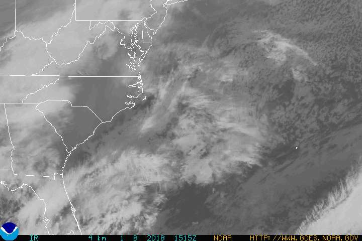
We can use the following links to see what’s going on in our area of the north central Pacific Ocean. Here's the latest NOAA satellite picture – the latest looping satellite image…and finally the latest looping radar image for the Hawaiian Islands.
Here are the latest 24-hour precipitation totals (inches) for each of the islands as of Wednesday evening:
0.10 Mount Waialeale, Kauai
0.31 Manoa Lyon Arboretum, Oahu
0.01 Molokai
0.00 Lanai
0.00 Kahoolawe
0.17 Puu Kukui, Maui
0.18 Mountain View, Big Island
Sunset Commentary: The trade winds will remain stronger than normal through the rest of the week…easing up some as we get into next week. The NWS forecast office in Honolulu has pared the small craft wind advisories back to just those windiest locations around Maui County, and the Big Island. The overlying atmosphere remains stable, and also somewhat drier than normal at the moment. As this satellite image shows, there continues to be just a few of those lower level clouds upstream of the islands at the moment. These cumulus and stratocumulus clouds will bring a few windward showers, but not many through most of Wednesday night. We can also see a thin strip of high cirrus clouds over the state as well. As we get into Thursday morning, and lasting into the weekend, our lower level clouds and showers will increase…especially in the windward areas. The leeward sides, at least on the smaller islands, can expect to see some of these showers too.
Here in Kula, Maui at 530pm, it was partly cloudy with light breezes, with an air temperature of 75F degrees. As was the case at sunrise this morning, we should get to see some more color at sunset this evening again. These high cirrus clouds will remain over the state for a little while longer, and then depart. As noted above, there will be an increase in windward showers Thursday morning through the rest of this week, at least at times. This is due to the arrival of additional moisture from the east, and the crossing of the islands by an upper level low pressure system, which will enhance our local showers. This isn't going to be a major rainfall event, although there will be more then the ordinary amount of showers, considering the season. ~~~ I'll be back early Thursday morning with your next new weather narrative, I hope you have a great Wednesday night wherever you happen to be spending it! Aloha for now…Glenn.
Worldwide tropical cyclone activity:
Atlantic Ocean: Post-tropical cyclone Beryl has moved offshore into the Atlantic Ocean, crossing the Gulf Stream through the night. It was located about 65 miles west-southwest of Cape Hatteras, North Carolina, with 40 mph winds at the time of this writing. Here is the NHC graphical track map, along with a satellite image of this area. The forecast shows this system strengthening, with tropical storm force winds developing. The NHC has issued its last advisory on not retiring tropical depression Beryl.
~~~ Conditions in the atmosphere and the ocean favor a near-normal hurricane season in the Atlantic Basin this season. For the entire six-month season, which begins June 1, NOAA’s Climate Prediction Center says there’s a 70 percent chance of nine to 15 named storms (with top winds of 39 mph or higher), of which four to eight will strengthen to a hurricane (with top winds of 74 mph or higher) and of those one to three will become major hurricanes (with top winds of 111 mph or higher, ranking Category 3, 4 or 5). Based on the period 1981-2010, an average season produces 12 named storms with six hurricanes, including three major hurricanes.
Eastern Pacific: There are no active tropical cyclones. The NHC has announced that climate conditions point to a near-normal hurricane season in the Eastern Pacific this year. The outlook calls for a 50 percent probability of a near-normal season, a 30 percent probability of a below-normal season and a 20 percent probability of an above-normal season.
Seasonal hurricane forecasters estimate a 70 percent chance of 12 to 18 named storms, which includes 5 to 9 hurricanes, of which 2 to 5 are expected to become major hurricanes (Category 3, 4 or 5 on the Saffir-Simpson Hurricane Wind Scale).
An average Eastern Pacific hurricane season produces 15 named storms, with eight becoming hurricanes and four becoming major hurricanes. The Eastern Pacific hurricane season runs from May 15 through Nov. 30, with peak activity from July through September.
Central Pacific: There are no active tropical cyclones. Here in the central part of the Pacific, the hurricane season begins as of June 1. The Central Pacific Hurricane Center in Honolulu is forecasting 2-4 tropical cyclones in this part of the Pacific Basin…which is slightly below the average number. An average season has 4-5 tropical cyclones, which include tropical depressions, tropical storms and hurricanes.
Western Pacific Ocean: There are no active tropical cyclones.
Interesting: Researchers are working on 'nano-film' packaging materials to extend the shelf-life of fruit and vegetables and reduce huge post-harvest losses in South Asia. The project follows studies at Tamil Nadu Agriculture University (TNAU) showing that a nano-film that emits a chemical vapor can extend the shelf-life of vegetables by up to 21 days without any deterioration in quality.
Now, researchers at TNAU have linked up with collaborators in Canada and India to test such novel nano-materials on mangoes during a 30-month project launched in March. The project involves the University of Guelph in Canada, TNAU in India, the Industrial Technology Institute (ITI) in Sri Lanka, and MYRADA, a nongovernmental organization based in southern India. K. S. Subramanian, professor at TNAU's department of nanoscience and technology, told SciDev.Net that the average person in India consumes only 80 grams of fruit a day — half the recommended amount — despite the country being a top fruit producer.
"The main reason [for the low fruit intake] is post-harvest losses," said Subramaniam, who heads the research project. A lack of cold storage and cold chain facilities within India means that at least 40 per cent of the fruit harvested is lost — worth around US$71 million (four billion Indian rupees).
To tackle the problem, the researchers are developing nanomaterials impregnated with synthetic versions of an agent called hexanal, which is found in trace amounts in plants such as beans and cucumbers. Hexanal helps extend the freshness and shelf-life of fruit and vegetables by targeting an enzyme called phospholipase-D, which is responsible for fruit and vegetable deterioration.
Farmers in some countries use hexanal sprays on crops, but this is not practical in hot countries where the chemical vaporises quickly. The Canadian scientists developed the synthetic hexanal and the TNAU team is planning to test such hexanal impregnated into natural plant fiber. This fiber slowly releases the chemical onto the food to stop the enzyme activity.
Meanwhile, the Sri Lankan scientists will test hexanal embedded in a natural wax, which, if successful, would then be used for nano-film coating. TNAU scientists have started spraying mango crops with hexanal in three mango-growing areas in southern India's Tamil Nadu state to test its effectiveness. They expect to have the novel nano-film ready for testing in the first half of 2014.
However, Alok Dhawan, director of the Institute of Life Sciences at Ahmedabad University and founder of the Indian Nanoscience Society, cautioned that nanofilms containing hexanal as packaging materials would need studies on the environmental impact.
This is because consumers would throw the wrappings away, and they would be dumped in land-fills. Hexanal's antimicrobial properties could also destroy some natural biodegrading bacteria in the environment, Dhawan added, suggesting that the effect on ecosystems would also need to be studied.
peter mac Says:
grow food where it is eaten~~~Hi Peter, eating locally grown food, when it is good, seems like a practical thing to do, I agree. Aloha, Glenn