


April 25-26, 2010
Air Temperatures – The following maximum temperatures were recorded across the state of Hawaii Sunday afternoon:
Lihue, Kauai – 81
Honolulu, Oahu – 85
Kaneohe, Oahu – 81
Kaunakakai, Molokai – 81
Kahului, Maui – 85
Hilo, Hawaii – 81
Kailua-kona – 82
Air Temperatures ranged between these warmest and coolest spots near sea level around the state – and on the highest mountains…at 4pm Sunday afternoon:
Kalaeloa, Oahu – 85F
Molokai airport – 77
Haleakala Crater – 55 (near 10,000 feet on Maui)
Mauna Kea summit – 45 (near 14,000 feet on the Big Island)
Precipitation Totals – The following numbers represent the largest precipitation totals (inches) during the last 24 hours on each of the major islands, as of Sunday afternoon:
0.27 Mount Waialaele, Kauai
0.33 Oahu Forest NWR, Oahu
0.00 Molokai
0.00 Lanai
0.00 Kahoolawe
0.92 Kawainui Stream , Big Island
Marine Winds – Here’s the latest (automatically updated) weather map showing high pressure systems far to the northeast and west-northwest of the islands. This pressure configuration will bring back strengthening trades Monday and Tuesday.
Satellite and Radar Images: To view the cloud conditions we have here in Hawaii, please use the following satellite links, starting off with this Infrared Satellite Image of the islands to see all the clouds around the state during the day and night. This next image is one that gives close images of the islands only during the daytime hours, and is referred to as a Close-up visible image. This next image shows a larger view of the Pacific…giving perspective to the wider ranging cloud patterns in the Pacific Ocean. Finally, here’s a Looping IR satellite image, making viewable the clouds around the islands 24 hours a day. To help you keep track of where any showers may be around the islands, here’s the latest animated radar image.
Hawaii’s Mountains – Here’s a link to the live webcam on the summit of near 14,000 foot Mauna Kea on the Big Island of Hawaii. The tallest peak on the island of Maui is the Haleakala Crater, which is near 10,000 feet in elevation. These two webcams are available during the daylight hours here in the islands…and when there’s a big moon rising just after sunset for an hour or two! Plus, during the nights and early mornings you will be able to see stars, and the sunrise too…depending upon weather conditions.
Tropical Cyclone activity in the eastern and central Pacific – Here’s the latest weather information coming out of the National Hurricane Center, covering the eastern north Pacific. You can find the latest tropical cyclone information for the central north Pacific (where Hawaii is located) by clicking on this link to the Central Pacific Hurricane Center. Here’s a tracking map covering both the eastern and central Pacific Ocean. A satellite image, which shows the entire ocean area between Hawaii and the Mexican coast…can be found here. Of course, as we know, our hurricane season won’t begin again until June 1st here in the central Pacific.
Aloha Paragraphs

Kona coast…on the Big Island
The trade winds will be increasing in strength into the new week. These trade winds will become rather strong and gusty through mid-week, then become softer through the rest of the week. The computer models show an area of low pressure digging southward towards us starting Thursday into Friday. This will cause our trade winds to falter again, and will swing them around to the southeast. Southeast winds can carry volcanic haze up from the
Sunday was an exceptionally dry day, although as the trade winds increase soon…we’ll begin to see a few more windward biased showers arriving. There will be those occasional showers along our windward sides, although they won’t bring on a wet spell…typically falling just during the night and early morning hours. Looking at this IR satellite image, we don’t see hardly any clouds at the time of this writing! If we open up our view even further, by shifting over to this bigger picture, we still don’t see anything that looks like a threat.
It’s Sunday evening as I begin writing this last section of today’s narrative. As noted above, we had another great day Sunday, with shower activity at a bare minimum. The trade winds are on the increase again, although showers won’t be all that frequent through the next several days. We do see a rather distinct weather change during the second half of the upcoming week. This will entail a change in wind direction, which will eventually lead to a period of light and variable winds by the weekend. There will be one or two sources of moisture arriving during the Thursday into the weekend time frame. There will be more details about this less windy and potentially wetter period as we move through the next several days.
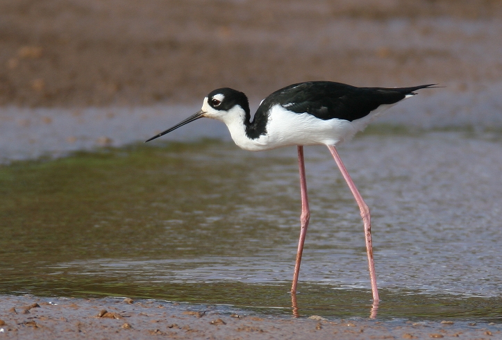
~~~ Yesterday, being Saturday, I took advantage of having the day off from work. I started off by driving down to Kahului to mess around. I went to a couple of stores, although the main fun was had elsewhere. There’s this little water canal that goes through the Kahului Industrial Center, which I’ve always had an interest in. Each time I drive through, usually on the way to a film after work on Friday’s…I make a special effort to glance at that water. I’ve been meaning to stop by there, to go exploring that narrow water way, for a long time. Well, today I finally made the time to do that, and walked almost the entire length, which by the way is strewn with weeds along the way. I saw lots of little tiny fish, along with three Hawaiian Stilts, and a heron. It was such a good thing to do, after wanting to do it for so long, like a major accomplishment of sorts! I then drove down the coast to Sprecklesville, and did some putting, like in golf. There was no one around at the Country Club, at least on the putting green, so I took my time, and played through the five holes many times. Then I took the short drive down to Baldwin Beach, and sat on the warm and sunny beach, watching the kids playing at the waters edge. I took a nice little swim in the refreshing ocean, which felt good. I then went shopping in Paia, and after that, came home and had some chocolate ice cream with a sliced banana. This may not seem all that exciting to many of you, although for me…it was a great way to spend a day off from work!
~~~ Today, being Sunday, I didn’t go anyplace, that is after having a nice long walk during the morning. The sunshine was abundant everywhere today, even on the often cloudy windward sides. It was one of those special days in fact, when everyone got to do whatever they wanted to do, in respect to being outdoors. I anticipate that Monday will be similar, as will be Tuesday and Wednesday…although windier and with a few more showers along our windward sides too. The bigger change, as noted above, will occur during the second half of the week. I’ll have much more to say about that Thursday through Sunday weather period, moving forward from here.
~~~ I did quite a bit of work here at home today, and still have more to finish. One of the things that I enjoyed doing was putting together a red pasta sauce. I sauteed organic onion, garlic, 5-6 thin anchovy filets, baby bock choy, a zucchini, asparagus spears and mushrooms…together with a can of organic diced tomatoes. I’ll boil up pasta each evening, add the sauce and capers, along with ground hard cheese…and have an easy dinner through Thursday. Right now I’m to get at those last few things I need to complete, then take a walk, have dinner, and get back to my reading before sleep time. I hope you had a great weekend too! I’ll meet you here again early Monday morning. Aloha for now…Glenn.
Interesting: Indo-Pacific lionfish, an invasive carnivore equipped with venomous spines, are spreading—and eating their way—through the fishes of the Caribbean Sea. In an effort to stop, or at least slow down, these fearless invaders, the National Science Foundation has awarded a 3-year, $700,000 grant to scientists at Oregon State University (OSU), Corvallis. The lionfish are normally found in Pacific Ocean waters.
But since the 1990s, they’ve been spotted from Florida to Rhode Island, and as far south as Colombia, and are now wreaking havoc among the fishes of Caribbean coral reefs—adding yet another woe to those already facing the reefs.
"We want to understand why lionfish are so successful," in their new habitats, says Mark Hixon, a marine biologist at OSU and leader of the newly funded research effort. Rare in their native waters, the lavishly striped and decorated fish (Pterois volitans) are booming on the reefs around the Bahama Islands, Hixon’s previous work shows.
In a controlled experiment in 2005, his team recorded the lionfish’s voracious appetite. A single one can reduce the number of other fishes by 79% in as few as 5 weeks. The researchers witnessed colorful cardinal fish, parrotfish, damselfish all going down the lionfish’s gullet.
One consumed 20 small fish in 30 minutes. "It seems that the native fish don’t perceive lionfish as fish," perhaps because of the predator’s markings, Hixon says. "They swim right up to it," only to end up being swallowed whole.
Many of the small reef fish are herbivores and help keep seaweed in check; without them, Hixon and others predict that seaweed may grow rampantly, overwhelming the reefs’ ecosystem. Hixon’s new study will compare lionfish populations in the Pacific and Atlantic oceans to try to sort out why they are rare at home, but thriving in foreign seas.
"Something, a parasite, predator, or disease," is limiting them in the Pacific, says Hixon. If the researchers can discover what that is, they hope to find—and foster—a similar lionfish attacker in the Atlantic. Native groupers in the Bahamas might prey on lionfish, but because groupers have been overfished, they are unlikely to significantly reduce the invaders.
Plus, in experiments, Hixon has found that neither groupers nor sharks are particularly keen to eat the lionfish. "They don’t look like their conventional prey," and the groupers and shark don’t seem to enjoy the venomous spike that comes with the meal. Hixon has larger hopes for humans as consumers of lionfish.
The fish are fairly easy to catch, are tasty, and could even carry a green label. "They could be advertised as a conservation dish," he says, noting that there is a lionfish cookbook in the works.
Interesting2: Eyjafjallajökull and its massive cloud of volcanic ash clearly have had an enormous impact on Europe and its airports, disrupting the mobility of millions and costing airlines more than a billion euros. But what about the volcano’s effect globally? While much more difficult to determine, Northwestern University professor Dirk Brockmann and his research group jumped at the chance to examine the global impact.
Mobility patterns in places far from Europe — including the United States, India and southeast Asia — were significantly affected by the European disruption, to the surprise of Brockmann. The team compared the entire worldwide air transportation network before and after the 27 major European airports were closed and used complex network theory to compute and list the most affected airports still operating.
"We were surprised to discover that at the top of the list were airports outside of Europe, not airports in Europe," Brockmann said. "Singapore, Hong Kong and Beijing are some of the high-traffic airports most affected, despite being geographically distant from Europe and separated from Iceland by continents."
He and his graduate students Daniel Grady, Christian Thiemann and Olivia Woolley also found that airports like Madrid and Dubai have become more central in the entire air transportation network, taking over the role of the closed airports. Brockmann and his group have expertise in running simulations and computational models of human transportation networks and pandemic diseases.
He is associate professor of engineering sciences and applied mathematics at Northwestern’s McCormick School of Engineering and Applied Science. "European airports are bridges to the world — the majority of global air traffic goes through Europe," Brockmann said.
"The distances to places have increased globally as a result of the volcanic ash disruption. Mumbai, for example, has become more disconnected than we expected from the U.S. and Africa. Flights from the U.S. to Mumbai normally go through Europe, but now Mumbai is a more distant city to us."
A trip that may have required two flights before the volcano’s eruption might have taken four or five trips when the situation was at its worst, which translates into more time, says Brockmann. At the peak of the disruption, with the 27 major European airports closed, 10 percent of the entire global air traffic system was removed.
The slowdown in air traffic affected not only the mobility of people but that of fresh vegetables and fruit, grains and other food, medicine, machinery parts and more. "The removal of those 27 nodes dramatically affects the entire complex system," said Brockmann. "We can quantify Eyjafjallajökull’s effect and illustrate it, which is not a simple thing to do."
"In this case, the entire air transportation system was slowed but still works," said Brockmann, who most recently studied the spread of swine flu. "Our calculations show that an actual system breakdown requires the removal of 80 percent of the airports from the system. This shows how robust the system is.
Interesting3: Ice-covered volcanoes like the one in Iceland that brought European air traffic to a standstill are the center of an emerging branch of volcano science that seeks to answer important questions about climate change. Scientists believe the rocks created when volcanoes erupt beneath glaciers contain distinct chemical signatures that indicate the thickness of the ice that was above the volcanoes when they blew.
By correlating the thickness with the age of the rocks, researchers can estimate the degree to which Earth was covered by glaciers thousands — or even millions — of years ago. That information is crucial to climatologists who want to understand how ice and temperature conspire to make the globe cool down or heat up.
"In the big global climate models that they run on supercomputers, ice cover on the Earth is very important," said Ian Skilling, a volcanologist at the University of Pittsburgh. Paleoclimatologists already have a good idea about temperatures in the planet’s distant past, thanks to sediment samples from the ocean floor.
But ocean temperatures, though an important factor in understanding the history of the planet’s climate, are only part of the story. Scientists don’t understand very well how changes in ocean temperature are linked with ice conditions on land, said Ben Edwards, a volcanologist at Dickinson College in Carlisle, Pa.
Combining the ocean data with information from volcanic rocks "will give us a much better feel for how global climate changes in the course of time," he said. The rocks formed by volcanoes covered by glaciers have some distinctive features. They have relatively smooth edges, on account of banging into ice on their way out of the crater.
Those edges also have a glassy rind that forms because ice causes magma to cool extremely quickly. The glass contains water, carbon dioxide and sulfur dioxide. The concentration of water is determined in part by the pressure above the volcano before it erupts — an indication of the thickness of the ancient ice layer that covered it.
"Higher water content means higher pressure on that glass when it was forming," Skilling said. "It gives you some idea of just how far beneath the surface it was." Ice thickness is important because it helps scientists figure out how long a glacier lasted in a particular place.
It also gives scientists clues about how warm the air was, how much sunlight was reflected back into space, and how high sea levels were, Skilling said. Edwards recently collected rocks from about 40 volcanoes in British Columbia that were covered by glaciers when they erupted. "We want to correlate when there were big ice sheets on land with the cold spells recorded in the ocean," he said.
But North American volcanoes erupt somewhat sporadically. To get a more continuous record of glacial conditions, the neighbors of the erupting Eyjafjallajokull volcano could be particularly helpful, he said. Volcanologists have calculated glacier thickness for several times and places, and so far they match up with ocean temperatures from the same periods. Edwards said he expects to find many more matches.
Interesting4: A strong 6.1-magnitude quake has rocked the central region of Chile which was hit by the massive February 27 tremor, the US Geological Service says. The epicenter of the quake, which struck at 10.03am GMT on Friday (8.03pm AEST) was 65km south of Concepcion, Chile, the USGS said. The 8.8-magnitude February 27 quake – one of the largest on record – struck off Concepcion, triggering a local tsunami. At least 452 people were killed and the disaster caused some $US30 billion in damage.
Interesting5: There’s a "good possibility” than a volcano will burst through the streets of Auckland in the next few hundred years. New Zealand’s most populous city is already studded with at least 50 volcanoes – the last, Rangitoto Island, emerged in the Haraki Gulf about 700 years ago. Auckland University geologist Phil Shane says "a new little one pops up” in Auckland every 1000 years, "so you could have an eruption in our lifetime” Auckland is built on a "volcanic field”, Dr Shane said.
"Rather than a new (volcano) bursting through the old eroded remains of an ancient one, often they pop up in a new place.” Auckland’s bustling main strip, Queen Street, would be a "candidate”, he said. "A place like Queen Street wouldn’t be out of the question. "Equally, it could happen out in the harbor or somewhere else. "Unfortunately, it’s very hard to forecast (when) something like this is going to happen unless we’re only … like weeks or months away from it happening,” Dr Shane said.