


Air Temperatures – The following maximum temperatures were recorded across the state of Hawaii Saturday:
Lihue, Kauai – 81
Honolulu airport, Oahu – 86 (record for Saturday – 92 in 1987)
Kaneohe, Oahu – 80
Molokai airport – 83
Kahului airport, Maui – 86 (record for Saturday – 92 in 1953, 1994)
Kona airport 84
Hilo airport, Hawaii – 83
Air Temperatures ranged between these warmest and coolest spots near sea level – and on the highest mountain tops…as of 7pm Saturday evening:
Barking Sands, Kauai – 82
Kaneohe, Oahu – 76
Haleakala Crater – 45 (near 10,000 feet on Maui)
Mauna Kea Summit – 37 (over 13,500 feet on the Big Island)
Here are the 24-hour precipitation totals (inches) for each of the islands as of Saturday evening:
1.34 Mount Waialeale, Kauai
0.46 Oahu Forest NWR, Oahu
0.00 Molokai
0.00 Lanai
0.00 Kahoolawe
0.38 West Wailuaiki, Maui
1.10 Kawainui Stream, Big Island
Marine Winds – Here’s the latest (automatically updated) weather map showing a 1025 millibar high pressure system to the north of our islands. Our local trade winds will remain active Saturday and Sunday.
Satellite and Radar Images: To view the cloud conditions we have here in Hawaii, please use the following satellite links, starting off with this Infrared Satellite Image of the islands to see all the clouds around during the day and night. This next image is one that gives close images of the islands only during the daytime hours, and is referred to as a Close-up visible image. Finally, here's a Looping IR satellite image, making viewable the clouds around the islands 24 hours a day. To help you keep track of where any showers may be around the islands, here’s the latest animated radar image.
Hawaii’s Mountains – Here’s a link to the live web cam on the summit of near 13,500 foot Mauna Kea on the Big Island of Hawaii. The tallest peak on the island of Maui is the Haleakala Crater, which is near 10,000 feet in elevation. These two web cams are available during the daylight hours here in the islands…and when there’s a big moon shining down during the night at times. Plus, during the nights you will be able to see stars, and the sunrise and sunset too…depending upon weather conditions.
Tropical Cyclone activity in the eastern and central Pacific – Here’s the latest weather information coming out of the National Hurricane Center, covering the eastern north Pacific. You can find the latest tropical cyclone information for the central north Pacific (where Hawaii is located) by clicking on this link to the Central Pacific Hurricane Center. A satellite image, which shows the entire ocean area between Hawaii and the Mexican coast…can be found here. Here's a tropical cyclone tracking map for the eastern and central Pacific.
Aloha Paragraphs
Strong trade winds, just a few showers…
especially on the windward sides at night
The trade winds will be locally blustery through Monday…starting Tuesday they will ease up some through the remainder of the week. Glancing at this weather map, we find our primary high pressure system weighing-in at 1025 millibars…located to our north. The placement of this area of high pressure, and its associated ridge running westward from the center, will keep our trade winds blowing. We now have small craft wind advisories active throughout all the major channels, and all the coastal areas around the state as well.
Our trade winds will remain active…the following numbers represent the strongest gusts, along with directions Saturday evening:
31 Port Allen, Kauai – ENE
27 Waianae, Oahu – NE
29 Molokai – NE
38 Kahoolawe – NE
36 Kahului, Maui – ENE
15 Lanai – NE
42 South Point, Big Island – NE
We can use the following links to see what’s going on in our area of the north central Pacific Ocean Saturday night. Looking at this NOAA satellite picture we find stable lower level clouds to the east and northeast of the Hawaiian Islands. At the same time we find a thick streak of high cirrus clouds over the central part of the island chain. We can use this looping satellite image to see low clouds being carried towards our windward sides by the trade winds. The departing upper level low pressure system to our west is spinning away. We find a rather thick area of high cirrus clouds moving over us from the southwest. Checking out this looping radar image we see very few showers being carried along in the trade wind flow, keeping a minimal amount of showers falling over windward sides…particularly during the night.
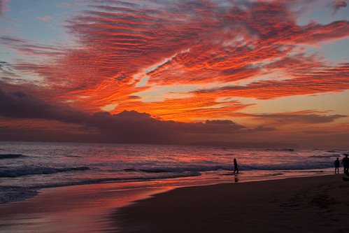
Sunset Commentary: The strong and gusty trade winds are keeping just a few passing showers in the forecast. Very often during trade wind episodes, the night and early morning hours find the most frequent precipitation. It appears that through Sunday our rainfall will be limited, with a possible increase along our windward sides during the new work week coming up.
Meanwhile, if you're a fan of high cirrus clouds, you're in luck. These icy clouds up high, at the jet stream levels of the atmosphere, are moving over parts of the state from the deeper tropics. Checking out this looping satellite image, we see one particularly thick streak of high clouds moving over the center of the state from the southwest. They of course delight our local communities with colorful sunset and sunrise colors. They will of dim and filter our sunshine during the days too, although Sunday should be quite a sunny day in many areas.
I went to see a new film Friday evening after work called Super 8, starring Kyle Chandler and Elle Fanning…among many others. A synopsis: in the summer of 1979, strange and unusual disappearances begin to take place, in a small town after a catastrophic train crash. By the way, the critics are giving this film a B grade, while the viewers are providing a slightly better B+ rating. I was surprised at how entertaining this film turned out to be. I read several of the comments that others shared about this film, which seemed to dismiss the film as just ordinary, or even worse. There were many who had very positive things to say as well. I come down towards the positive side, and can easily give it a soft B+. There was the big time action of course, which was fun to watch. I have to say though, that there were some touching scenes involving the relationships between the actors, which gave the film heart. Here's a trailer if you have an interest in seeing what J.J. Abrams and Steven Spielberg have produced.
Looking out the windows of my Kula, Maui weather tower early this evening, I see thick cirrus clouds overhead. Although in checking out the satellite images above, they are restricted to the area from Oahu down through Maui County at the moment. The islands of Kauai and the Big Island were outside of this cirrus shield. I expect a good looking sunset, at least where the high clouds are present. These high clouds will still be around on Sunday, so we may be in for another dazzling sunrise, like we saw early Saturday. All things considered, our weather will remain pleasant, with gusty trade winds, and limited showers everywhere through the rest of this weekend. I'll catch up with you again Sunday morning, when I'll be back with your next new weather narrative from paradise. I hope you have a great Saturday night until then! Aloha for now…Glenn.