


Air Temperatures – The following maximum temperatures were recorded across the state of Hawaii Thursday:
Lihue, Kauai – 81
Honolulu airport, Oahu – 86 (record high Wednesday: 91 – 1996)
Kaneohe, Oahu – 80
Molokai airport – 85
Kahului airport, Maui – 85
Kona airport 85
Hilo airport, Hawaii – 82
Air Temperatures ranged between these warmest and coolest spots near sea level – and on the highest mountain tops…as of 5pm Thursday evening:
Honolulu, Oahu – 83
Hilo, Hawaii – 75
Haleakala Crater – missing (near 10,000 feet on Maui)
Mauna Kea summit – 30 (over 13,500 feet on the Big Island)
Here are the 24-hour precipitation totals (inches) for each of the islands as of Thursday evening:
0.75 Mount Waialeale, Kauai
0.13 Nuuanu Upper, Oahu
0.00 Molokai
0.00 Lanai
0.00 Kahoolawe
0.15 Puu Kukui, Maui
0.39 Glenwood, Big Island
Marine Winds – Here’s the latest (automatically updated) weather map showing a 1033 millibar high pressure system…to the northeast of our islands. Our local winds will remain brisk Friday, becoming lighter Saturday.
Satellite and Radar Images: To view the cloud conditions we have here in Hawaii, please use the following satellite links, starting off with this Infrared Satellite Image of the islands to see all the clouds around during the day and night. This next image is one that gives close images of the islands only during the daytime hours, and is referred to as a Close-up visible image. Finally, here's a Looping IR satellite image, making viewable the clouds around the islands 24 hours a day. To help you keep track of where any showers may be around the islands, here’s the latest animated radar image.
Hawaii’s Mountains – Here’s a link to the live web cam on the summit of near 13,500 foot Mauna Kea on the Big Island of Hawaii. The tallest peak on the island of Maui is the Haleakala Crater, which is near 10,000 feet in elevation. These two web cams are available during the daylight hours here in the islands…and when there’s a big moon shining down during the night at times. Plus, during the nights you will be able to see stars, and the sunrise and sunset too…depending upon weather conditions.
Tropical Cyclone activity in the eastern and central Pacific – Here’s the latest weather information coming out of the National Hurricane Center, covering the eastern north Pacific. You can find the latest tropical cyclone information for the central north Pacific (where Hawaii is located) by clicking on this link to the Central Pacific Hurricane Center. A satellite image, which shows the entire ocean area between Hawaii and the Mexican coast…can be found here.
Aloha Paragraphs

Trade winds – localized showers…a few thunderstorms
Our local winds will continue to be active from the trade wind direction…remaining brisk through Friday. Glancing at this weather map, we find a 1033 millibar high pressure system located to our northeast…with ridges extending from its center to the west-southwest and east-southeast. These trade winds will remain active, with the small craft wind advisories covering those windiest coasts and channels from south of Oahu, to Maui County and around parts of the Big Island. The trade winds will begin relaxing some this weekend into early next week. The trade winds will become very light, and perhaps even veering to the east-southeast, or southeast by Sunday into Monday and Tuesday. This unusual wind shift and downgrade in speed will bring humid and muggy weather to the state. It will take returning trade winds to offer back refreshing environmental conditions. We could even see some volcanic haze (vog) begin to filter in over the smaller islands with time.
Our trade winds will continue to blow briskly…the following numbers represent the strongest gusts, along with directions Thursday evening:
33 Port Allen, Kauai – ESE
30 Honolulu, Oahu – NE
33 Molokai – NE
38 Kahoolawe – E
32 Kahului, Maui – NE
20 Lanai – NE
35 South Point, Big Island – NE
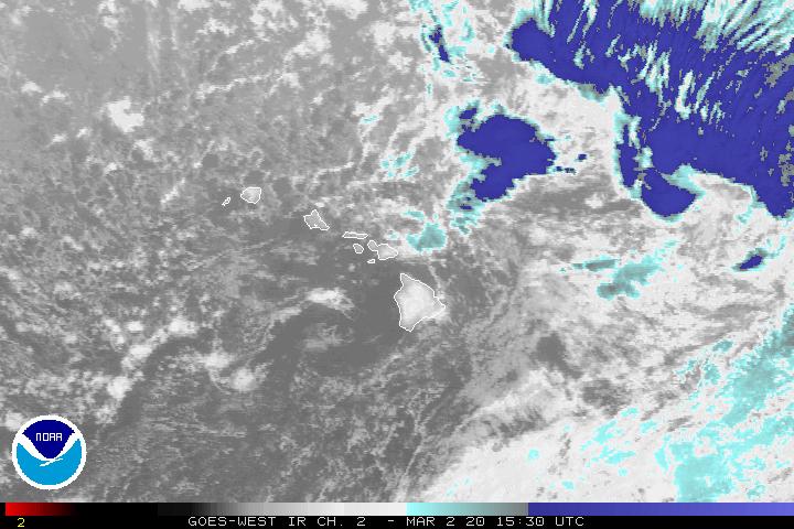
We can use the following links to see what’s going on in our area of the north central Pacific Ocean Thursday night. Looking at this NOAA satellite picture we see that most of the clouds in our area are located over the ocean, especially to the north of Kauai, and to the southwest of the central islands to some extent. We can use this looping satellite image to see areas of high and middle level clouds moving by to our south and then veering up towards the northeast. We can also see the counterclockwise rotating upper level low pressure system near Kauai, with towering cumulus and thunderstorms forming in its rotation field. Checking out this looping radar image we see showers over and around the islands, although nothing overly heavy at the time of this writing. The Big Island’s north Kona area, and also the Kohala District, as well as those showers over the ocean were most active at the time of this writing.
Sunset Commentary: The expected heavy showers took a break from most areas of the islands today, although that may change. The most dynamic showers are falling over the ocean to the north of Kauai at the moment, although there were some pretty good downpours over parts of the Big Island during the afternoon hours too. The NWS forecast office in Honolulu issued a notice of locally heavy rains and thunderstorms over the interior and leeward sections on the Big Island…until Thursday evening.
The upper level low pressure system sitting over us, and especially the western islands, has abnormally cold air associated with it. As a matter of fact, and as the NWS pointed out: the air over Lihue, Kauai was the coldest it’s been during June…since 1973! This is making our overlying atmosphere very unstable, and shower prone too. The one problem, at least for the moment, is that there seems to be a lack of available moisture at lower levels, to fuel these potentially heavy showers or thunderstorms.
This satellite image with its blue tint, shows where the coldest cloud tops are located, which happens to be just to the north of Kauai, and to some degree north-northwest of Oahu as well. There’s also that thick band of high and middle level clouds moving by in the subtropical jet stream to our east. Meanwhile, the winds are still blowing, gusting up towards 40 mph in those windiest spots. These will fade away this weekend, which will pull the rug out from under the trades into early next week. A light wind convective pattern will settle in over the state then, with muggy conditions, and still the chance of afternoon showers, some locally heavy through Monday or Tuesday. It’s that time of the year however, when the trade winds won’t stay away for long…and will come charging back into our area shortly thereafter.
Here in Kihei, Maui at 530pm Thursday evening, skies were partly cloudy, with a mix of high cirrus and lower level cumulus clouds. By the way, those cirrus clouds will likely light up pink or orange at sunset, and perhaps again at sunrise on Friday. Heavy showers, other than those around the Big Island this afternoon, remained offshore from the islands for the most part. We still aren't out of the woods however, at least in terms of more showers, even a few thunderstorms here and there too. Kauai is the closest to those heavier showers at the moment, although that could change during the night. I'll look forward to catching up with you again early Friday morning, when I'll be back online to prepare your next new weather narrative. I hope you have a great Thursday night until then! Aloha for now…Glenn.
Interesting: World Environment Day is a day that is supposed to stimulate awareness of the environment and enhance political attention and public action. The official day is June 5. This was the day that the United Nations Conference on the Human Environment began. The first World Environment Day was on 1973.
The theme this year is Forests-Nature At Your Service. Forests cover one third of the earth’s land mass, performing vital functions and services around the world which make our planet alive with possibilities. In fact, 1.6 billion people depend on forests for their livelihoods. They play a key role in the world ecology, releasing oxygen into the atmosphere while storing carbon dioxide.
Thousands of activities are typically organized worldwide, with beach clean-ups, concerts, exhibits, film festivals, community events and much more. Each year there is a different host city. For 2011 it is New Delhi, India. Forests cover 31% of total land area while at the same time supporting 80% of terrestrial biodiversity that live in them. Many of the world’s most threatened and endangered animals live in these forests, making them crucial to sustaining ecosystems. Not only animals live in the forests, as they also provide a home to more than 300 million people worldwide.
Beyond supporting the natural habitat, forests sustain economic growth. In 2004 trade in forest products was estimated at $327 billion. Continued and uncontrolled deforestation therefore not only has devastating consequences for the environment, the wildlife and communities, but for economies around the world. Rather shockingly, 36 million acres of natural forest are lost each year.
Interesting2: China is on a severe tobacco crackdown to show that they are taking World No Tobacco Day seriously. Industry figures show that China produced 2.38 trillion cigarettes in 2010, rising a staggering 40% over the past decade. The tobacco industry currently generates about 7% of the government's annual revenue. However last year, the cost incurred by people smoking outweighed the tobacco profits and jobs created by $9.5 billion.
Tobacco kills 1.2 million Chinese every year according to official figures. China has more than 300 million smokers with second-hand smoke affecting about 740 million people, according to the 2011 China Tobacco Control Report released by the Chinese Center for Disease Control and Prevention (China CDC) Thursday in Beijing.
China has ratified the World Health Organization Framework Convention on Tobacco Control (WHO FCTC). But the treaty's implementation is in the hands of a multi-agency work group that includes the State Tobacco Monopoly Administration, the regulatory body that shares the same management staff with China National Tobacco Corporation.
Calls to kick tobacco industry representatives out of the multi-agency work group in charge of implementing the WHO treaty have been mounting in the health sector for some time. A survey conducted by the China CDC shows less than 25% of the population have a thorough knowledge of the harm posed by smoking and second-hand smoke.
Voluntary smoking controls have proved ineffective, with laws and regulations being the only effective way of curbing the habit. Without a reduction in consumption of tobacco in China, global tobacco control cannot make big strides. The government for its part is making strides in curbing tobacco use.
In February, the State Administration of Radio, Film and Television (SARFT) ordered film and TV studios to restrict smoking scenes and to ban shots showing tobacco brands or minors in scenes while others are smoking. In March, a revised regulation on health management in public places issued by the Ministry of Health said smoking would be banned in enclosed public locations, which took effect in May this year.
Interesting3: Brazilian authorities gave final approval to the controversial Belo Monte dam, reports AFP. The project — which has been widely opposed by human rights groups, environmentalists, and indigenous tribes — will dam the Xingu river, one of the largest tributaries of the Amazon River. The $11 billion dam will generate 11,200 megawatts of electricity, more than 10 percent Brazil's current capacity, when it is completed in 2019. Construction of the dam is expected to displace 16,000 people, according to the Brazilian government, although environmentalists estimate that 40,000 could be forced to move.
Amazon Watch, a group campaigning against Belo Monte, says the dam will flood more than 40,000 hectares of rainforest. "This is a tragic day for the Amazon," said Atossa Soltani, Executive Director at Amazon Watch. "By turning a blind eye toward the tragic consequences of this dam, President Dilma Rouseff is undermining the positive environmental and social advances Brazil has made in recent years and miring its image on the global stage just as it prepares to host the UN Rio+20 Earth Summit next year."
The project — which has been widely opposed by human rights groups, environmentalists, and indigenous tribes — will dam the Xingu river, one of the largest tributaries of the Amazon River. The $11 billion dam will generate 11,200 megawatts of electricity, more than 10 percent Brazil's current capacity, when it is completed in 2019.
Construction of the dam is expected to displace 16,000 people, according to the Brazilian government, although environmentalists estimate that 40,000 could be forced to move. Amazon Watch, a group campaigning against Belo Monte, says the dam will flood more than 40,000 hectares of rainforest.
"This is a tragic day for the Amazon," said Atossa Soltani, Executive Director at Amazon Watch. "By turning a blind eye toward the tragic consequences of this dam, President Dilma Rouseff is undermining the positive environmental and social advances Brazil has made in recent years and miring its image on the global stage just as it prepares to host the UN Rio+20 Earth Summit next year."
A report entitled The State of the Forests in the Amazon Basin, Congo Basin and South East Asia, was released to coincide with a summit in the Congo Republic bringing together delegates from 35 countries occupying those forests, with a view to reaching a global deal on management and conservation. The Amazon and the Congo are the world's first and second biggest forests, respectively, and its third biggest — the Borneo Mekong — is in Indonesia.
They sink billions of tons of carbon and house two thirds of the world's remaining land species between them. The study found that annual rate of deforestation across the three regions, which account for more than 80 percent of the world's tropical forests, was 5.4 million hectares between 2000 and 2010, down a quarter from 7.1 million hectares in the previous decade. Statistics showed that forest destruction in the Congo basin had remained stable but low over the last 20 years, while in South East Asia the rate of deforestation more than halved.
Countries which had previously had high levels of forest loss, such as Brazil and Indonesia, have had some success tackling the problem through better conservation awareness and government policy said the report's author, Mette Wilkie. But she suggested this was no cause for complacency, especially of the threat from farming. "Deforestation is higher than it ought to be," Wilkie told Reuters. "The Amazon basin has large scale land conversion for farming and crops, Congo has small scale conversion, mainly for subsistence farming, while South East Asia is a mixture."