


Air Temperatures – The following maximum temperatures were recorded across the state of Hawaii Wednesday:
Lihue, Kauai – 78
Honolulu airport, Oahu – 79
Kaneohe, Oahu – 79
Molokai airport – 81
Kahului airport, Maui – 85
Kona airport – 82
Hilo airport, Hawaii – 79
Air Temperatures ranged between these warmest and coolest spots near sea level – and on the highest mountain tops…as of 5pm Wednesday evening:
Kailua-kona – 77F
Hilo, Hawaii – 68
Haleakala Crater – 43 (near 10,000 feet on Maui)
Mauna Kea summit – 25 (over 13,500 feet on the Big Island)
Precipitation Totals – The following numbers represent the largest precipitation totals Wednesday evening:
1.42 Mount Waialeale, Kauai
1.89 Waiawa, Oahu
0.50 Molokai
0.04 Lanai
0.00 Kahoolawe
2.57 Puu Kukui, Maui
4.02 Pohakuloa Keamuku, Big Island
Marine Winds – Here’s the latest (automatically updated) weather map showing a large 1043 millibar high pressure system to the north-northeast of Hawaii. Our winds will become gradually lighter, trending towards the southeast over the open ocean…with daytime onshore sea breezes in closer to the islands through Thursday. There could be localized stronger winds in the vicinity of thunderstorms.
Satellite and Radar Images: To view the cloud conditions we have here in Hawaii, please use the following satellite links, starting off with this Infrared Satellite Image of the islands to see all the clouds around during the day and night. This next image is one that gives close images of the islands only during the daytime hours, and is referred to as a Close-up visible image. This next image shows a larger view of the Pacific…giving perspective to the wider ranging cloud patterns in the Pacific Ocean. Finally, here's a Looping IR satellite image, making viewable the clouds around the islands 24 hours a day. To help you keep track of where any showers may be around the islands, here’s the latest animated radar image.
Hawaii’s Mountains – Here’s a link to the live web cam on the summit of near 13,500 foot Mauna Kea on the Big Island of Hawaii. The tallest peak on the island of Maui is the Haleakala Crater, which is near 10,000 feet in elevation. These two web cams are available during the daylight hours here in the islands…and when there’s a big moon rising just after sunset for an hour or two! Plus, during the nights and early mornings you will be able to see stars, and the sunrise too…depending upon weather conditions.
Tropical Cyclone activity in the eastern and central Pacific – Here’s the latest weather information coming out of the National Hurricane Center, covering the eastern north Pacific. You can find the latest tropical cyclone information for the central north Pacific (where Hawaii is located) by clicking on this link to the Central Pacific Hurricane Center. Here’s a tracking map covering both the eastern and central Pacific Ocean. A satellite image, which shows the entire ocean area between Hawaii and the Mexican coast…can be found here. Of course, as we know, our hurricane season ended November 30th here in the central Pacific…and begins again June 1st.
Aloha Paragraphs

Variable clouds with localized showers, some of which will
be heavy, with isolated thunderstorms into Thursday.
Flash flood watch through Thursday night…all islands
Generally light to moderately southeast breezes will remain in place through Saturday…before the trade winds return later this weekend briefly for a short stint. According to this weather map, we find a strong 1043 millibar high pressure system positioned to the north-northeast of the islands Wednesday night. Meanwhile, we have a weak 1015 millibar low pressure system just to our northwest. Looking even further northwest, way up in the Bering Sea, we see a very deep 946 millibar storm low pressure system…with developing hurricane force winds. The long and short of all this means that our winds will remain southeast, which may be quite gusty over the open ocean, although remain on the lighter side closer to shore in those wind blocked smaller islands.
There may be some strong and gusty winds associated with thunderstorms tonight into Thursday, or even a waterspout over the ocean…like there were during the day locally Wednesday. At the same time we have a small craft wind advisory around Kauai and Oahu, due to the rough seas in those Hawaiian waters…as well as a high surf advisory for most east facing shores across the state. The latest model output suggests that we could see a brief period of returning trade winds beginning this coming Sunday, lasting through Monday and perhaps into Tuesday. Then, if the models have it right, another approaching trough of low pressure will swing our winds back to the southeast later Tuesday into Wednesday. Thereafter, it's still too far into the future to know will happen with our winds then.
Light to moderately strong breezes, locally stronger at times will prevail through much of the rest of this week…the following numbers represent the strongest gusts, along with directions Wednesday evening:
18 mph Port Allen, Kauai – S
16 Kahuku, Oahu – SW
13 Molokai – NE
33 Kahoolawe – SE
25 Kahului, Maui – NE
00 Lanai Airport
30 South Point, Big Island – NNE
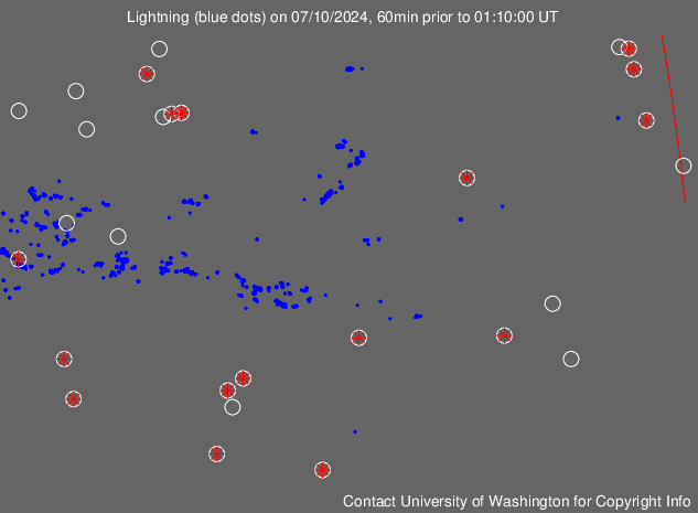
We can use the following links to see what’s going on in our area of the north central Pacific Ocean Wednesday night. This large University of Washington satellite image shows an extensive amount of deep convection (thunderstorms and tower cumulus) surrounding the Hawaiian Islands in all directions. Looking at this NOAA satellite picture we see lots of multi-layered clouds out over the ocean and over the islands too. We can use this looping satellite image to see the counterclockwise circulation of an upper low pressure system channeling moisture into our area. At the same time, there are lots of thunderstorms over and around the islands. Checking out this looping radar image shows moderately heavy showers falling over and around the islands, locally heavy with thunderstorms in places too.
In summary: All the ingredients came together this afternoon, producing locally heavy rainfall on all the islands. The day started off wet on Oahu, and then each of the other islands got into the act. Flood advisories were issued for the islands, as the heavy rains made their rounds. The daytime heating seemed to be the impetus for these rains, coupled of course with the cold air aloft, and the abundant moisture at lower altitudes of the atmosphere. The Big Island was cold today, where over the summits, locally heavy snows fell. As this web cam shot shows, snow was covering the lens thoroughly on Mauna Kea…viewable during the daylight hours. In contrast, the cold air aloft hadn't reached lower elevations, so that the Haleakala Crater remained much warmer…with no sign of any white stuff.
These unsettled weather circumstances will last through the night, and likely right on into Thursday. This in turn will keep the threat of heavy rains, and thunderstorms in the forecast. Conditions should become less dynamic by Friday into the weekend, although lighter showers remain a distinct possibility even then. Bringing the discussion back to now, there were reports of damages locally today, associated with the flooding on a few islands. At the same time, there were several reports of waterspout sightings over the ocean, mostly near Kauai and Oahu. I would suggest keeping your guard up while driving, as the roads will be slick, with poor visibilities while this wet weather continues.
Here in Kihei, Maui, at around 540pm, skies were partly cloudy…after just a couple of the lightest sprinkles fell here during the afternoon. I got an email from my neighbors up in Kula this afternoon, and they sent pictures of heavy downpours. Skies have actually begun to clear some as we move towards sunset. Maui had some heavy rains, generally in the upcountry areas, with mostly light showers reported elsewhere. We missed the bullet today, so to speak…in contrast to the other islands. However, I should point out the amount of shower and rain activity that's still around by showing you this looping radar link. This strongly suggests that the state as a whole isn't exactly "out of the woods" just yet! Look for the chance of more rain tonight, and I'm sure that most anyone will see at least some lightning flashes in the distance, or right overhead here and there. I'll be back early Thursday morning with your next new weather narrative. I hope you have a safe Wednesday night until then. Don't forget to drive carefully! Aloha for now…Glenn.
Extra: Lightning strike detections for the Pacific Ocean…around the Hawaiian Islands
Interesting: The huge tsunami triggered by the 9.0 Tohoku Earthquake destroyed coastal towns near Sendai in Japan, washing such things as houses and cars into the ocean. Projections of where this debris might head have been made by Nikolai Maximenko and Jan Hafner at the International Pacific Research Center, University of Hawaii at Manoa.
Maximenko has developed a model based on the behavior of drifting buoys deployed over years in the ocean for scientific purposes. The debris first spreads out eastward from the Japan Coast in the North Pacific Subtropical Gyre.
In a year, the Northwestern Hawaiian Islands Marine National Monument will see pieces washing up on its shores; in two years, the remaining Hawaiian islands will see some effects; in three years, the plume will reach the US West Coast, dumping debris on Californian beaches and the beaches of British Columbia, Alaska, and Baja California.
The debris will then drift into the famous North Pacific Garbage Patch, where it will wander around and break into smaller and smaller pieces. In five years, Hawaii shores can expect to see another barrage of debris that is stronger and longer-lasting than the first one.
Much of the debris leaving the North Pacific Garbage Patch ends up on Hawaii's reefs and beaches. These model projections will help to guide clean-up and tracking operations. Tracking will be important in determining what happens to different materials in the tsunami debris, for example, how the composition of the debris plume changes with time, and how the winds and currents separate objects drifting at different speeds.
Even before the tsunami, the World Ocean was a dump for rubbish flowing in from rivers, washed off beaches, and jettisoned from oil and gas platforms and from fishing, tourist, and merchant vessels. Marine debris has become a serious problem for marine ecosystems, fisheries, and shipping.
The presentations given at the recent week-long 5th International Marine Debris Conference in Hawaii, at which Maximenko had organized a day-long workshop, are a testimony to the magnitude of the ocean debris problem. The massive, concentrated debris launched by the devastating tsunami is now magnifying the hazards.
Maximenko's long-standing work on ocean currents and transports predicted that there are five major regions in the World Ocean where debris collects if it is not washed up on shores or sinks to the ocean bottom, deteriorates, or is ingested by marine organisms. These regions turn out to be "garbage patches."
The North Pacific Garbage Patch has become famous, the North Atlantic Patch was fixed some years ago, and the South Atlantic, South Indian Ocean, and South Pacific patches have just been found, guided by the map of his model that shows where floating marine debris should collect.
Interesting2: A new partnership for Mediterranean forests has been established to address major threats to the region's forests being exacerbated by the severe impact of climate change. The partnership was announced at the Second Mediterranean Forest Week, which is taking place in Avignon, France (5-8 April).
"The Collaborative Partnership on Mediterranean Forests will help raise awareness on the wealth of vital functions Mediterranean forests provide. These include soil and water protection, landscape values, carbon sequestration and biodiversity conservation.
It is urgent that we join efforts to restore and preserve their functions for future generations," said Eduardo Rojas-Briales, Assistant Director-General of the FAO Forestry Department.
The partnership involves 12 institutions and organizations including FAO and will focus primarily on six countries in the southern and eastern Mediterranean: Morocco, Algeria, Tunisia, Syria, Lebanon and Turkey.
The new partnership offers a way for stakeholders in the region to address the mounting challenges facing Mediterranean forests and draw greater attention to their value and the urgent need to protect them.
The Mediterranean Basin every year loses between 0.7 and one million hectares of forests due to fires, corresponding to an economic loss of an estimated €1 billion. The Mediterranean region is confronted with a considerable increase in longer and more frequent drought and heat waves, resulting in the growing risk of large scale forest fires as well as more water scarcity, affecting both rural and urban populations.
Forests affected by numerous threats Total forest area in the Mediterranean region is 73 million hectares, or 8.5 percent of the region's total land area. Mediterranean forests provide a diversity of products such as wood, non-wood forest products including cork, fodder for livestock and aromatic plants and game, all of which are important for socio-economic development and contribute to food security and poverty alleviation in rural areas.
But Mediterranean forests also are facing a mix of threats such as climatic change, agricultural expansion, tourism, urban development and other land use practices that are contributing to forest losses. For example, in the northern Mediterranean, where forest land is mostly privately-owned, vegetation has spread extensively as a result of natural dynamics and, as a consequence of the lack of hands-on management, the risk of wildfires has increased.
In the south, growing pressure on forest resources by overgrazing, forest clearance for other uses, over-collection of fuel wood and charcoal are among the factors contributing to forest degradation and deforestation. Action needed at all levels
The partnership is designed to integrate policies and investments at the country level in order to adapt forests to climate change; this would involve sectors such as forestry, agriculture, urban development, water, environment, land use planning, education and tourism.
It is also aimed at developing a joint regional approach to forest management and in particular, to wildfire prevention, through the sharing of expertise, knowledge and best practices. At a local level the partnership will help to promote sustainable forest management among all stakeholders, including local communities, forest owners and managers, farmers, herders, environmentalists, protected areas managers and researchers.
Interesting3: Substance abuse has trended upward among American teens over the past three years after a decade of declines, according to a report issued on Wednesday by the Partnership at Drugfree.org. It said marijuana and ecstasy use among teens shows marked increases while attitudes toward alcohol use have become more relaxed.
The study, sponsored by MetLife Foundation and the 22nd in an annual series, found that between 2008 and 2010 teens who said they had used marijuana in the past year climbed to 39 percent from 32 percent. Between 2008 and 2010, teens who said they had used the "party" drug ecstasy in the past year increased to 10 percent from six percent.
The Partnership Attitude Tracking Study, which based its findings on a survey of around 2,500 high school students, found that 45 percent said they do not see a "great risk" in heavy daily drinking, while 31 percent strongly disapprove of their peers getting drunk.
A total of 68 percent of those surveyed said they had had at least one drink in their lifetimes. Among them, the average age for that drink was 14. Sean Clarkin, director of strategy for the Partnership at Drugfree.org, which last year changed its name from the Partnership for a Drug Free America, said the normalization of drug use in social media, the proliferation and discussion of medical marijuana, and budget cuts to substance abuse prevention programs have contributed to the rise of substance use and abuse.
"There are very high levels of kids reporting that they are using drugs and alcohol to deal with stress," Clarkin told Reuters in a phone interview, adding that the struggles families face in the current economy could be a factor in that.
"The net impact of all that puts an even heavier burden on parents who really need to play a active roll in preventing this behavior and knowing how to get help for a kid when they are abusing any of these substances," Clarkin said.
Interesting4: With global demand for electronics surging — especially for tablet computers like Apple's iPad — these gadgets' sophistication and long battery life have created a huge market for rare earth minerals, often associated with global conflicts. Elements like copper and even rarer tungsten, neodymium, dysprosium, coltan, and terbium are tagged with the "conflict" label because of their concentration in the eastern regions of the Democratic Republic of Congo.
This area that borders Rwanda has been the scene of a war that supposedly concluded in 2003, but still produces hostilities between various warring factions. Much of the fighting has been funded by the extraction of these conflict minerals, and children have found themselves forced into the dirty and dangerous work required to ready these elements for export.
With activists and consumers increasingly frustrated over the dubious sources from which our electronics are manufactured, a coalition of manufacturers, government agencies, and non-profits launched the Conflict-Free Smelter (CFS) program last December.
The CSF identifies smelters through independent third party auditors who can assess that raw materials did not originate from sources that profit off the conflict in the Democratic Republic of Congo.
Now Intel and Apple have stopped purchasing minerals from this region, which has transformed a voluntary program to what the president of an exporter association in Congo called "an embargo." Some advocates may applaud Apple and Intel for taking this step, but the reality is that the two tech giants did not have much of a choice.
When the Dodd-Frank Wall Street Reform Act passed through the American Congress and won President Obama's signature last July, one section buried in the bill (revealing the brilliance or madness of how America churns legislation) issued regulations to prevent the purchase of conflict minerals, effective this month.
The enforcement of this prevision has been left to the Securities and Exchange Commission (SEC), which in 2012 will require companies to audit their mineral supplies to verify that any purchases were not made from vendors that have any affiliation with the conflict in eastern Congo.
Interesting5: Two reports by addiction researchers at the University of Pennsylvania School of Medicine and the National Institute on Drug Abuse show a drastic shift in prescribing patterns impacting the magnitude of opioid substance abuse in America. The reports, published in JAMA, recommend a comprehensive effort to reduce public health risks while improving patient care, including better training for prescribers, pain management treatment assessment, personal responsibility and public education.
The JAMA Research Report shows that there has been a drastic increase in opioid prescriptions while prescriptions for non-steroidal anti-inflammatory drugs (NSAIDs) have gone down. Prescriptions for hydrocodone and oxycodone account for 84.9 percent of opioid prescriptions.
Over ten years, there has been a fivefold increase in admissions to substance abuse programs for opioid addiction. While effective at reducing pain symptoms, opioid medications such as hydrocodone and oxycodone are associated with high rates of abuse, particularly among young adults.
One in four 18-25 year olds will abuse prescription pain killers in their lifetime. Researchers suggest targeting the relatively high rate of prescriptions to adolescents and young adults, who received 11.7 percent of the 202 million opioid prescriptions in the United States during 2009.
A large share of the prescriptions to young adults was from dentists, and researchers believe there is a need for medical professionals to evaluate alternative pain medications in this particularly vulnerable age group.
"The scope of the problem is vast — opioid overdose is now the second leading cause of accidental death in the United States and the prevalence is second only to marijuana," said Thomas McLellan, PhD, co-author of the studies and director of the new Center for Substance Abuse Solutions, housed in the Department of Psychiatry at the University of Pennsylvania School of Medicine.
"This study provides valuable information about factors contributing to the high rates of opioid analgesics, and identifies areas ripe for intervention." In the accompanying Commentary, researchers offer recommendations to improve current pain management in primary care while simultaneously decreasing diversion, abuse and overdoses of opioid medication. These recommendations include:
* Comprehensive and contemporary training for pain management care providers -including physicians, nurses, dentists and pharmacists — covering the latest research advances on pain and addiction and new drug treatment options.
* Supporting the American Pain Society guidelines, which include plans to develop and roll out screening procedures for those at risk for abuse and dependence (e.g. adolescent or young adults, individual or family history of substance abuse history.)
* Increasing public awareness and responsibility of the addiction risks, to curb sharing or theft of the medication within families.