


Air Temperatures – The following maximum temperatures were recorded across the state of Hawaii Thursday:
Lihue, Kauai – 81
Honolulu airport, Oahu – 85
Kaneohe, Oahu – 79
Molokai airport – 73
Kahului airport, Maui – 74
Kona airport – 83
Hilo airport, Hawaii – 80
Air Temperatures ranged between these warmest and coolest spots near sea level – and on the highest mountain tops…as of 5pm Thursday evening:
Honolulu, Oahu – 81F
Kaneohe, Oahu – 75
Haleakala Crater – missing (near 10,000 feet on Maui)
Mauna Kea summit – 43 (over 13,500 feet on the Big Island)
Precipitation Totals – The following numbers represent the largest precipitation totals Thursday evening:
0.28 Mount Waialeale, Kauai
0.03 Honolulu airport, Oahu
0.02 Molokai
0.00 Lanai
0.00 Kahoolawe
0.15 West Wailuaiki, Maui
0.42 Honaunau, Big Island
Marine Winds – Here’s the latest (automatically updated) weather map showing a 1029 millibar high pressure system to the northeast of Hawaii. Our trade winds will be active Friday…becoming lighter from the southeast Saturday.
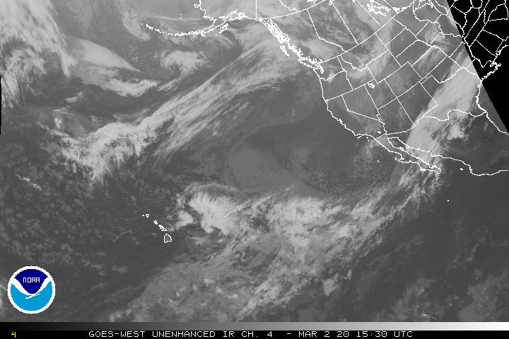
Satellite and Radar Images: To view the cloud conditions we have here in Hawaii, please use the following satellite links, starting off with this Infrared Satellite Image of the islands to see all the clouds around during the day and night. This next image is one that gives close images of the islands only during the daytime hours, and is referred to as a Close-up visible image. This next image shows a larger view of the Pacific…giving perspective to the wider ranging cloud patterns in the Pacific Ocean. Finally, here's a Looping IR satellite image, making viewable the clouds around the islands 24 hours a day. To help you keep track of where any showers may be around the islands, here’s the latest animated radar image.
Hawaii’s Mountains – Here’s a link to the live web cam on the summit of near 13,500 foot Mauna Kea on the Big Island of Hawaii. The tallest peak on the island of Maui is the Haleakala Crater, which is near 10,000 feet in elevation. These two web cams are available during the daylight hours here in the islands…and when there’s a big moon rising just after sunset for an hour or two! Plus, during the nights and early mornings you will be able to see stars, and the sunrise too…depending upon weather conditions.
Tropical Cyclone activity in the eastern and central Pacific – Here’s the latest weather information coming out of the National Hurricane Center, covering the eastern north Pacific. You can find the latest tropical cyclone information for the central north Pacific (where Hawaii is located) by clicking on this link to the Central Pacific Hurricane Center. Here’s a tracking map covering both the eastern and central Pacific Ocean. A satellite image, which shows the entire ocean area between Hawaii and the Mexican coast…can be found here. Of course, as we know, our hurricane season ended November 30th here in the central Pacific…and begins again June 1st.
Aloha Paragraphs

Friday's going to be a nice day at the beach
Artist Credit: Pierre Bouret
The trade winds will remain active through Friday…and then be fading away. According to this weather map, we find a 1029 millibar high pressure system to the northeast of the islands Thursday night. The small craft wind advisory remains active over the entire state…due to the locally breezy trade winds and large northwest swell. The NWS office in Honolulu is also keeping the high surf advisory up through early Friday morning for the large swell breaking now. Our winds are expected to remain from the trade wind direction through Friday. As we move into the weekend however, an approaching cold front will weaken and swing the winds around to the east-southeast or southeast. The winds will take on an easterly trade wind direction through much of next week.
Trade winds will continue Friday…the following numbers represent the strongest gusts, along with directions Thursday evening:
27 mph Port Allen, Kauai – E
27 Honolulu, Oahu – E
28 Molokai – NE
28 Kahoolawe – E
32 Kahului, Maui – NE
21 Lanai Airport
31 South Point, Big Island – NE
We can use the following links to see what’s going on in our area of the north central Pacific Ocean Thursday night. This large University of Washington satellite image shows lots of clouds to our north, much of which is high cirrus…associated with a cold front in the middle latitudes of the north central Pacific. Looking at this NOAA satellite picture we see the southern extent of those cirrus, along with some patchy lower level cumulus clouds scattered around our vicinity.
We can use this looping satellite image to see the quickly eastward moving high clouds to our north. There’s quite a few cumulus clouds being carried along in the trade wind flow. Checking out this looping radar image shows some showers in our vicinity, with most of those falling over the ocean at the time of this writing…although at least some will be arriving along our windward sides…perhaps increasing to some degree as we move through the night into Friday morning.
In Sum: Steady as we go, at least through tomorrow, with rather dry conditions, and a pretty normal early spring trade wind pattern. As mentioned below, a late season cold front is evident on satellite image to our north now…actually the tail-end of a cold front. As this front digs further south in our direction this weekend, it will push our trade wind producing high pressure ridge down towards our islands. This will cause our trade winds to falter, with lighter winds settling in at our tropical latitudes.
As this happens we’ll find muggy and hazy weather for a few days, perhaps into Monday. The lighter winds will put us into a convective weather pattern, with clear slightly cool mornings (if there are no high cirrus clouds around then), giving way to afternoon cumulus cloud buildups over and around the mountains. These clouds could drop a few showers, although we’ll have to wait until some point between Monday and next Wednesday…for the heavier stuff to arrive. This will hinge upon whether there is enough cold air aloft, and the clouds with the cold front arrive, and to what degree that all comes together. If everything works out as planned, there could even be a few flashes of lightning…and a clap or three of thunder around the edges.
Here in Kihei, Maui, at around 540pm, skies were clear to partly cloudy, with breezy trade winds blowing too. I'm about ready to head back upcountry to Kula, and to quickly jump into my walking clothes. I'll be back early Friday morning with your next new weather narrative. I hope you have a great Thursday night until then! Aloha for now…Glenn.
Interesting: The long, feathery lines of condensation that form behind aircraft, called contrails, have more of an immediate warming effect on the Earth's surface than the carbon dioxide or other greenhouse gases that the aircraft emit, a new study calculates. However, the researchers add, contrail clouds disappear within a day or two; the potent greenhouse gas carbon dioxide lingers in the air for many years.
Contrails form when the hot, moist plume of exhaust generated by an airplane's engines mixes with cold air in the upper atmosphere. Liquid droplets form and then freeze, forming a straight, white line. Over the span of a few hours or more, the contrail loses its definition and becomes a wispy cirrus cloud.
But if the atmosphere is very moist, the line shape can exist for days, said Ulrike Burkhardt, a researcher at the Institute for Atmospheric Physics at the German Aerospace Center. She and colleague Bernd Kärcher calculated contrails' effect on climate.
If there were no other clouds in the sky, contrail cirrus clouds would cover up to 10 percent of European skies and about 6 percent over the east coast of North America, another heavily trafficked region, they calculated. They disappeared from American skies briefly when nearly all airtraffic was grounded after the 9-11 attack.
Some research has indicated that this resulted in more variation in temperatures, particularly warmer daytime temperatures. Like natural clouds, contrails have contradictory effects on the Earth's surface temperature.
Their ice crystals reflect solar light, decreasing the amount of light and heat that reach the Earth's surface, but at the same time they trap long-wave radiation (such as infrared light) coming from the other direction, preventing it from heading into space after it gets reflected off the ground.
This heats the planet's surface. The thickness of the contrail clouds, technically known as the optical depth, determines how much heat they trap. Many are too thin to be visible to the human eye or satellites, and these thin contrail clouds contribute negligibly to warming, the researchers write in the most recent issue of the journal Nature Climate Change.
The size and shape of the contrails' ice particles are also important in determining how much heat is trapped, Kärcher said. Contrail clouds have another complex effect: They use up water vapor that normally could go into the formation of natural cirrus clouds, according to Kärcher and Burkhardt.
When all of these effects are considered, contrail clouds ultimately alter the Earth's energy budget in a way that warms it, by reducing the amount of energy that escapes back out into space, the team found. Greenhouse gases do the same thing, trapping energy that would otherwise escape into space and so warming the planet.
Airplanes emit greenhouse gases, including carbon dioxide, in addition to forming contrails. However, in terms of the immediate change in the Earth's energy budget, the contrail clouds have more impact than those emitted greenhouse gases, the researchers calculated.
Even so, carbon dioxide can linger in the atmosphere for hundreds of years, while contrail clouds lose their potency within days, Kärcher said. "Assuming a steady growth of air traffic, then contrails would remain for some time the most important aviation-related warming. If, on the other hand, aviation volume is decreasing, then carbon dioxide would become more important relative to contrail cirrus," Burkhardt wrote.
Interesting2: A flood of nutrients may have created an oxygen-starved ocean about 250 million years ago, preventing life from bouncing back for a few million years after a mass extinction wiped out 90 percent of marine species, a new study indicates. The enriched, yet oxygen-starved ocean would have been similar to today's dead zones that appear in the modern ocean often as a result of agricultural runoff, as in the Gulf of Mexico.
The Permian-Triassic extinction, which hit about 250 million years ago, is believed to have been the result of widespread volcanic eruptions in what is now Siberia, which poured carbon dioxide into the atmosphere. Although the dates are inexact so far, it seems that life took an unusually long time to recover — possibly as much as 5 million years.
Too much of a good thing Chemical evidence from limestone deposited on the ocean floor during this time indicates that too much of a particular kind of life — tiny photosynthetic organisms, like certain bacteria and possibly algae — may have kept other marine species from recovering and diversifying.
"There was actually a lot of life in the ocean, but the life was not the typical life you would expect to find in oceans today," said lead researcher Katja Meyer, a postdoctoral researcher at Stanford University.
The troublemakers appear to have been bacteria that can thrive without oxygen, including some that produce the toxic gas hydrogen sulfide. It's not clear whether or not algae — which need oxygen — were present, Meyer said.
Here's how it may have happened: The elevated carbon dioxide resulted in acid rain, which weathered the land (eroding sediments), releasing nutrients such as phosphorus, which were carried into the oceans with runoff.
The extra nutrients fed these tiny organisms, causing them to flourish in the sunny surface waters. But when they died and sank to the seafloor, their decomposition sucked oxygen out of the water, creating what is called an anoxic, or oxygen-free, environment.
The oceans also became sulfurous.
At other points in Earth's history, life has recovered more quickly from major setbacks. For instance, it took most animal groups hundreds of thousands of years to rebound after the Cretaceous-Tertiary extinction wiped out the dinosaurs, according to Lee Kump, a geoscientist at Pennsylvania State University who was not directly involved with the research, although he did provide feedback to the researchers and is Meyer's former adviser.
"Scientists have argued about causes, either it was just in the nature of evolution, when it gets set back so abruptly and so intensely… Or it could signal more persistent, inimical oceanic conditions that delayed recovery," Kump said.
The evidence Meyer and colleagues looked at the ratios of carbon isotopes — atoms with different molecular weights — for a clue as to what happened. By looking at limestone deposited beneath shallow and deep water at the time, they found a telltale difference between the ratios of a light carbon isotope, carbon 12 and the heavier carbon 13.
Photosynthesis is the process of taking in carbon dioxide and with the energy from sunlight, turning that into sugars needed to grow. It seems that photosynthetic life prefers the lighter version of carbon, carbon 12, leaving the heavier carbon 13 isotopes behind.
So, in shallow waters, where microscopic organisms were flourishing, little carbon 12 was deposited, compared with carbon 13. In deeper waters, there was more opportunity for decomposition to occur, which means the once-living tissues that had taken up carbon 12 released their contents into the water.
That meant limestone deposited in deeper waters had more carbon 12 to the limestone and shifting the ratio. The gradient they found between deep and shallow water deposits was twice as large as today's, indicating that a significant increase in photosynthesis was occurring.
The recovery Fortunately for larger marine organisms, these toxic oxygen-free conditions weren't sustainable. After the volcanoes stopped pouring carbon dioxide into the atmosphere, levels would have declined, decreasing the greenhouse gases effects on climate and weathering of land.
As a result, fewer nutrients would find their way into runoff. At the same time, organic matter and nutrients were being taken out of circulation as they were deposited on the seafloor, allowing biological productivity to return to normal, Meyer said.
Life on land at the time — insects, amphibians, the ancestors of mammals and reptiles — was also decimated by the Permian-Triassic. However, this study's results are relevant only to marine life, according to Meyer.
Interesting3: Nowhere is the problem of deforestation greater than in the tropical regions of the world. Specifically, Southeast Asia, which has vast tracts of primal rain forests, is at risk from excessive logging.
Recently, governments in that region have come under pressure from environmentalists to conserve what forests they have left. Officials in the state of Sarawak, the Malaysian region of Borneo, have said that 70 percent of their forest cover has been preserved.
However, after a review using Google Earth images, indications are that deforestation is much more widespread than is being claimed. Google Earth, the free planet-viewing software from Google uses satellite images from various programs such as GeoEye and TerraMetrics.
A study by the website, Mongabay.com has revealed an intricate network of logging roads and cleared forests across Sarawak. Some have estimated that up to 90 percent of its primary forest cover has been logged. What is left has been logged several times in the past 30 years.
Virgin forest has been converted to wood-pulp and timber plantations. The Chief Minister of Sarawak, Taib, says only 14 percent of the region's forest has been converted to timber plantations. He has invited independent observers to assess the situation.
"People can make many claims, but my government has been very deeply committed to sustainable management of our forest," he said in an interview with Sarawak Reports. "These are the simple facts and if people want to verify, they are welcome to Sarawak. I'll be open for… independent inspection and I have nothing to hide."
Unfortunately for Mr. Taib, satellite images are difficult to hide from. The images of Sarawak show a tremendous difference when compared to neighboring Kalimantan (Indonesian Borneo).
Now Taib is being pressured by campaigners who have linked him to a vast fortune of overseas properties. This undeclared and presumably illegal wealth is believed to stem from Taib's connection with Sarawak's logging companies. The campaign against Taib is led by Clare Rewcastle Brown, relative of the former UK prime minister, Gordon Brown.
She helps manage the Sarawak Report which has come under pressure by the government to halt their campaign. Lately, the Sarawak media has become especially critical, claiming that the deforestation is "probably the biggest environmental crime of our times."
Doug Sanner Says:
Glenn– Awesome site, been reading regularly as I prepare for an Oahu northshore trip next week. Are we looking like a rain out Weds/Thurs or just more rain than usual? Gotta be better than Seattle either way. D~~~Hi Doug, thanks for your note, rain out? Not quite sure, keeping checking back…as I’ll be updating this situation more and more as we get closer to your arriving. By the way, have a great time, I know you will! Aloha, Glenn
becky Says:
Aloha,
wondering if the high pressure systems are known to cause headachs and sinus trouble?~~~ Hi Becky, not sure quite honestly, I more often hear of people complaining about pains and aches from low pressure systems. Aloha, Glenn