


August 11-12, 2009
Air Temperatures – The following maximum temperatures were recorded across the state of Hawaii Tuesday afternoon:
Lihue, Kauai – 83
Honolulu, Oahu – 87
Kaneohe, Oahu – 85
Kahului, Maui – 80
Hilo, Hawaii – 86
Kailua-kona – 89
Air Temperatures ranged between these warmest and coolest spots near sea level – and on the highest mountains…at 4 p.m. Tuesday afternoon:
Barking Sands, Kauai – 91F
Kahului, Maui – 76
Haleakala Crater – 54 (near 10,000 feet on Maui)
Mauna Kea summit – 63 (near 14,000 feet on the Big Island)
Precipitation Totals – The following numbers represent the largest precipitation totals (inches) during the last 24 hours on each of the major islands, as of Tuesday afternoon:
1.37 Hanalei River, Kauai
0.54 Oahu Forest NWR, Oahu
0.30 Molokai
0.00 Lanai
0.00 Kahoolawe
1.62 West Wailuaiki, Maui
1.78 Honokaa, Big Island
Marine Winds – Here’s the latest (automatically updated) weather map showing two high pressure systems to the north and northeast of the islands. Winds will be gusty from the northeast near Oahu and Kauai, while lighter from the southeast over Maui and the Big Island…due to the passage of former Felicia.
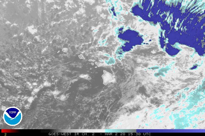
Satellite and Radar Images: To view the cloud conditions we have here in Hawaii, please use the following satellite links, starting off with this Infrared Satellite Image of the islands to see all the clouds around the state during the day and night. This next image is one that gives close images of the islands only during the daytime hours, and is referred to as a Close-up visible image. This next image shows a larger view of the Pacific…giving perspective to the wider ranging cloud patterns in the Pacific Ocean. Finally, here’s a Looping IR satellite image, making viewable the clouds around the islands 24 hours a day. To help you keep track of where any showers may be around the islands, here’s the latest animated radar image.
Hawaii’s Mountains – Here’s a link to the live webcam on the summit of near 14,000 foot Mauna Kea on the Big Island of Hawaii. The tallest peak on the island of Maui is the Haleakala Crater, which is near 10,000 feet in elevation. These two webcams are available during the daylight hours here in the islands…and when there’s a big moon rising just after sunset for an hour or two! Plus, during the nights and early mornings you will be able to see stars, and the sunrise too…depending upon weather conditions.
Tropical Cyclone activity in the eastern and central Pacific – Here’s the latest weather information coming out of the National Hurricane Center, covering the eastern north Pacific. You can find the latest tropical cyclone information for the central north Pacific (where Hawaii is located) by clicking on this link to the Central Pacific Hurricane Center. Here’s a tracking map covering both the eastern and central Pacific Ocean. A satellite image, which shows the entire ocean area between Hawaii and the Mexican coast…can be found here.
Aloha Paragraphs


Felicia moving between Maui and the Big Island
Former tropical cyclone Felicia will be a part of our Hawaiian Island weather picture through Wednesday…with returning trade wind weather Thursday. The Central Pacific Hurricane Center (CPHC) has dropped the tropical storm watch, and the flash flood watch across the entire state of Hawaii. What we’re left with is a small craft wind advisory for all coastal and channel waters statewide…and a high surf advisory for the east shores of all the islands.
As this dissipating tropical system moves across the southern part of the island chain, all of the islands will receive some showers. Once this showery weather moves west, past the state Wednesday, we’ll return to favorably inclined trade wind weather conditions statewide…lasting through the rest of the week into next week. Here’s a looping radar image of the Hawaiian Islands, so we can keep an eye on those showers moving through the state.
There has been a continued weakening of tropical cyclone Felicia Tuesday evening. The last CPHC forecast has been issued, as Felicia has dropped down below the tropical depression status. Here’s the last tracking map, showing the center of Felicia moving through the Alenuihaha Channel, between Maui and the Big Island. Here’s a satellite image showing this weakening tropical system in relation to the Hawaiian Islands…although it’s difficult to see it anymore.
~~~ As what’s left of Felicia moves through the state, we’ll see localized blustery winds, with gusts being enhanced where physical terrain features accelerate the flow. Some areas will be blocked from the strongest winds however, which will range generally between 25-35 mph…although there will be higher gusts locally as well. These gusty winds will remain active in some places into Wednesday….becoming lighter thereafter.
~~~ Finally, as this dissipated tropical depression continues its journey through the islands…we’ll see at least some clouds, and localized showers Tuesday night into Wednesday. It’s difficult to gauge exactly how much precipitation that we might receive by the end of this showery weather episode, but an estimate might be 1-2 inches in general, with higher amounts in a few places. The windward sides will find the largest amounts, although the leeward sides will find some precipitation as well.
It’s Tuesday evening here in Kihei, Maui, as I begin writing this latest update to the narrative. If you had a chance to read down this far on the page, you know that remnants of tropical depression Felica will be moving through the southern Hawaiian Islands during the next 24 hours. Here’s a looping satellite image of Felicia moving through between Maui and the Kohala/Hamakua area on the Big Island.
~~~ There will continue to be those localized blustery winds and showers which are still forecast to bring unusual weather conditions to the islands ..at least in terms of the summer season. Now that this storm has been sheared apart, the lower level circulation of the storm…the lower cloud swirl, is being directed along by the trade wind flow. Here’s a satellite image of Felicia and the Hawaiian Islands.
~~~ Meanwhile, a new tropical depression called 9E remains active in the eastern Pacific Ocean. This tropical cyclone is expected to strengthen into a tropical storm named Guillermo, and continue on into our central Pacific as a tropical storm. It’s present track timing would bring it into our part of the Pacific Ocean basin by this Friday evening. Here’s the NHC tracking map for this newly formed system. Here’s the satellite photo of 9E. The expected track shows, or at least we can project that 9E will remain well south of our Hawaiian Islands.
~~~ Meanwhile again, we find a tropical cyclone named 1C, which started down to the southwest of the Hawaiian Islands…again here in the central Pacific Ocean. We don’t need to worry about 1C, which was given the name tropical storm Maka recently…as it’s located 1100+ miles to the southwest of Honolulu. Here’s a tracking map…and a satellite image of that area.
~~~ The computer models continue to try and spin-up another storm in the eastern Pacific, which would be called 10E. If this system did spawn as expected, it would take on the name tropical storm Hilda. This would be another storm that would likely travel westward into our central Pacific Ocean. It’s still too early to know very much about this new storm, however the computer models do show it moving across the eastern Pacific, towards our central Pacific eventually.
~~~ So far, as we get into Tuesday night, after a long work day, I see that there have been 46,303 hits on this website, as of 845pm. At the same time there had been 659 google clicks…almost as many as the ~ 55,000 yesterday, which absolutely blows my mind, really! I want to thank each of you readers, it’s great to be writing about these storms and such…and know that you are reading about it. One more number while we’re tossing them out there, the grand total for this website during August so far, is 258,556 hits, with 4,560 google clicks…that’s over a quarter of a million hits, and we’re less than half way through the month…this deserves another exclamation point!
~~~ Finally, and I really mean finally this time, Tuesday was a very unusual day here in the islands. It didn’t look like the islands are "suppose to look" during the summer month of August! It was windy, and locally a wet day. Here in Kihei it was partly to mostly cloudy all day, with light drizzle and mist falling. It was pretty darn blustery too, even more than it usually is during the hot afternoons here on the south coast. I just looked outside before calling the Maui News for an interview about the weather, and the drizzle is coming down sideways! I’m curious to see what’s happening as I drive home to Kula. I’ll likely come back online later this evening for a minute and let you now.
~~~ It’s going on 9pm this evening, and it is absolutely still out, and the air temperature is hovering around 70F degrees…which feels very warm and humid. It was mostly cloudy, and showery on that drive home, with the cloud bases very low. I really must try and go to sleep now, as tomorrow is another day, as we all know. Plus, my Mom called me this evening and said something to the effect…"get some rest Glenn, you’ve been working too hard!" So, I’d best be following her directions, as I absolutely know she is looking out for my best health. Aloha for now…Glenn.