


August 4-5, 2009
Air Temperatures – The following maximum temperatures were recorded across the state of Hawaii Tuesday afternoon:
Lihue, Kauai – 81
Honolulu, Oahu – 87
Kaneohe, Oahu – 83
Kahului, Maui – 87
Hilo, Hawaii – 81
Kailua-kona – 87
Air Temperatures ranged between these warmest and coolest spots near sea level – and on the highest mountains…at 5 p.m. Tuesday evening:
Honolulu, Hawaii – 85F
Hilo, Hawaii- 73
Haleakala Crater – missing (near 10,000 feet on Maui)
Mauna Kea summit – 61 (near 14,000 feet on the Big Island)
Precipitation Totals – The following numbers represent the largest precipitation totals (inches) during the last 24 hours on each of the major islands, as of Tuesday afternoon:
0.51 Mount Waialaele, Kauai
0.30 Manoa Valley, Oahu
0.00 Molokai
0.00 Lanai
0.00 Kahoolawe
0.29 West Wailuaiki, Maui
0.27 Honaunau, Big Island
Marine Winds – Here’s the latest (automatically updated) weather map showing a 1030 millibar high pressure system to the north-northeast of the islands. This high pressure cell, along with its associated ridge to our north, will keep the trade winds blowing through Thursday.
Satellite and Radar Images: To view the cloud conditions we have here in Hawaii, please use the following satellite links, starting off with this Infrared Satellite Image of the islands to see all the clouds around the state during the day and night. This next image is one that gives close images of the islands only during the daytime hours, and is referred to as a Close-up visible image. This next image shows a larger view of the Pacific…giving perspective to the wider ranging cloud patterns in the Pacific Ocean. Finally, here’s a Looping IR satellite image, making viewable the clouds around the islands 24 hours a day. To help you keep track of where any showers may be around the islands, here’s the latest animated radar image.
Hawaii’s Mountains – Here’s a link to the live webcam on the summit of near 14,000 foot Mauna Kea on the Big Island of Hawaii. The tallest peak on the island of Maui is the Haleakala Crater, which is near 10,000 feet in elevation. These two webcams are available during the daylight hours here in the islands…and when there’s a big moon rising just after sunset for an hour or two! Plus, during the nights and early mornings you will be able to see stars, and the sunrise too…depending upon weather conditions.
Tropical Cyclone activity in the eastern and central Pacific – Here’s the latest weather information coming out of the National Hurricane Center, covering the eastern north Pacific. You can find the latest tropical cyclone information for the central north Pacific (where Hawaii is located) by clicking on this link to the Central Pacific Hurricane Center. Here’s a tracking map covering both the eastern and central Pacific Ocean. A satellite image, which shows the entire ocean area between Hawaii and the Mexican coast…can be found here.
Aloha Paragraphs
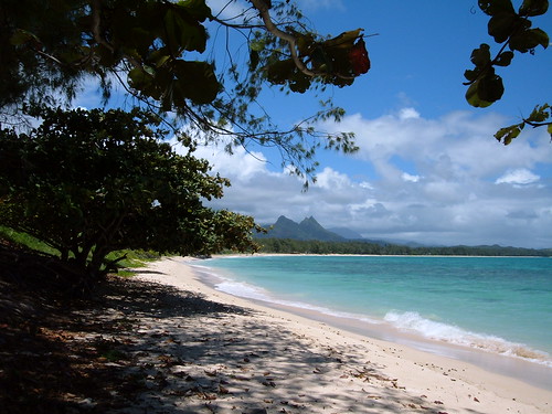
Beautiful Waimanalo Beach…Oahu
The trade winds will continue to blow across our Hawaiian Islands…increasing a notch now. The small craft wind advisory is still active Tuesday evening across those windiest areas from Oahu down through Maui County…into the Big Island. A 1029 millibar high pressure system to the north-northeast, is the source of our trade winds…as shown on this weather map.
Showers, being carried our way by the gusty trade winds, will be rather limited…but may increase as we head towards the weekend along our windward sides. The leeward beaches will remain generally dry, if not totally dry for the time being. This should allow abundant sunshine to be available along our south and west facing beaches. We may see tropical moisture arriving towards the weekend…into early next week.
We see two fairly closely spaced tropical systems in the eastern Pacific, one of which is hurricane Felicia…which will be traveling generally westward towards our central Pacific. We’ll need to keep a close eye on this storm as it enters our area. Here’s a tracking map, showing hurricane Felicia…with the
Our main focus through the rest of this work week, will be the tropical cyclone activity in the eastern Pacific…which comes into our central Pacific this weekend. The forecast charts show Felicia coming into our central Pacific as a weakening hurricane on Saturday, after reaching major hurricane status over the next couple of days. If we were to project beyond the outer forecast point, we would see Felicia moving by just south of the Big Island early next week. This could bring blustery weather, with increased rainfall…especially to the islands of Maui and the Big Island.
It’s Tuesday evening here in Kihei, Maui, as I begin writing this last part of today’s narrative. We’ve moved into the peak season for summer hurricane’s here in the central Pacific, so it’s not too surprising that we’re seeing tropical systems moving our way. Hurricane Felicia is a category 2 hurricane, which could exhibit a rapid intensification during the next day or so, bringing it briefly up to a category 3 hurricane. The forecast has Felicia weakening as it moves closer to our islands, dropping down into the less dangerous tropical storm classification. We still have almost a week to track this tropical cyclone before it gets close, and for me at least, I find it very interesting to say the least. ~~~ Back to the moment, Tuesday evening, our weather will be fine through the rest of this work week. The models show a possible increase in showers this weekend, although not associated with Felicia. This may or may not happen, but we have time to see if things are headed that way. ~~~ Speaking of heading that way, I’m about ready to take the drive back upcountry to Kula. I’ll have much more to say about hurricanes and such on Wednesday. I hope you have a great Tuesday night! Aloha for now…Glenn.
Interesting: A moderate earthquake with magnitude of 5.1 rocked eastern parts Indonesia on Tuesday, but noreport of damage or casualties, according to the country’s Meteorology and Geophysics Agency. The quake struck at 08:10 Jakarta time (2310 GMT Monday) with epicenter at 54 km northwest Manokwari of Papua and at 10 km in depth, the agency said.
Indonesia sits on a vulnerable quake-hit zone so called the Pacific Ring of Fire, where two continental plates stretching thatcause often triggers seismic and volcanic movements.
Interesting2: A magnitude-6.5 earthquake hit off Japan’s southern coast Wednesday, the country’s Meteorological Agency said. There were no immediate reports of damage or casualties. The quake hit at 9:18 am (0018 GMT) off the coast of Miyakojima, a southern island near Okinawa, at a depth of 18.6 miles.
Miyakojima is located about 1,240 miles (2,000 kilometers) south of Tokyo. The meteorological agency said there was no fear of a tsunami. Atsushi Kawamitsu, a police official in Miyakojima, said police have received no reports of damage or casualties.
"Nothing fell off from shelves during the quake," Kawamitsu said. Japan is one of the world’s most earthquake-prone countries, and experts believe Tokyo has a 90 percent chance of being hit by a major quake over the next 50 years. In 1995, a magnitude-7.2 quake in the western port city of Kobe killed 6,400 people.
Interesting3: Having a garden on your roof isn’t just nice for a garden party; it can make your city more environmentally friendly. Many American cities are beginning to incorporate greenroofs into their planning ordinances because they recognize that, planting a rooftop garden can offset heat, increase city biodiversity and decrease storm water runoff.
This runoff can be problematic in cities where rainwater is funneled by streets and parking lots directly into streams, carrying with it chemicals and debris and increasing the risk of flash floods. But the plants on greenroofs can absorb some of this water – "like a sponge being saturated," says Olyssa Starry, a graduate student at the University of Maryland at Baltimore County.
Starry studied a greenroof atop a Baltimore building in comparison to a similar building without a greenroof to determine how well the roof would absorb water from frequent storms. By measuring water flowing out of building downspouts, she found that the greenroof retained from 30 to 75 percent of water from storms, compared to a negligible amount retained by the building with no greenroof.
Although her results are preliminary, Starry thinks that cities can reap benefits from making greenroofs a part of their building requirements, as cities like Toronto and Berlin have recently done. Using GIS satellite imagery, she estimated the number and area of buildings that could hold greenroofs within one watershed in the Baltimore area.
If all these roofs were greened, she says, the city could save the watershed 8 million gallons of water per year, or about 10 percent of its yearly water loss. "We need to understand what implementing these greenroofs at the whole watershed scale can do," she says.
"Getting people to learn about this technology and providing incentives is the first step." This research was presented at the Ecological Society of America’s Annual Meeting on August 3, 2009.
Interesting4: US President Barack Obama and his wife Michelle are among the best-dressed people in the world, according to a list published today by Vanity Fair. Mr Obama, previously noted by fashion watchers as an unusually elegant dresser, joins Brad Pitt and James Bond actor Daniel Craig on a list of 10 men.
Michelle Obama, together with Carla Bruni, the wife of French President Nicolas Sarkozy, makes up the list of elegant first ladies. Others said by Vanity Fair to dress well include New York Mayor Michael Bloomberg, actress Anne Hathaway, and Princess Letizia of Asturias, wife of the heir to the Spanish throne.