


Air Temperatures – The following maximum temperatures (F) were recorded across the state of Hawaii Sunday…and the low temperatures Sunday:
79 – 69 Lihue, Kauai
84 – 72 Honolulu, Oahu
77 – 67 Molokai AP
78 – 70 Kahului AP, Maui
87 – 77 Kailua Kona
84 – 68 Hilo AP, Hawaii
Here are the latest 24-hour precipitation totals (inches) for each of the islands…as of Sunday evening:
0.53 Kilohana, Kauai
0.46 Ahuimanu Loop, Oahu
1.94 Puu Alii, Molokai
0.02 Lanai
0.03 Kahoolawe
12.92 West Wailuaiki, Maui!
1.94 Honokaa, Big Island
The following numbers represent the strongest wind gusts (mph)…as of Sunday evening:
28 Port Allen, Kauai – NE
32 Oahu Forest NWR, Oahu – S
20 Molokai – NNE
32 Lanai – NE
35 Kahoolawe – NNE
22 Kahului AP, Maui – NNE
38 Kohala Ranch, Big Island – NNE
Hawaii’s Mountains – Here’s a link to the live web cam on the summit of near 13,800 foot Mauna Kea on the Big Island of Hawaii. This web cam is available during the daylight hours here in the islands…and when there’s a big moon shining down during the night at times. Plus, during the nights you will be able to see stars, and the sunrise and sunset too…depending upon weather conditions.
Aloha Paragraphs

A low pressure system over the ocean to the north-northeast…along
with its associated comma shaped cold front draping southwest
from its center

A late season cold front is parked over the eastern islands…
with thunderstorms far south

Partly cloudy to mostly cloudy, as a cold front has
become nearly stationary over Maui County

Showers falling locally…mostly over Maui
and the Big Island – Looping radar image
Flood Advisory…windward east Maui
~~~ Hawaii Weather Narrative ~~~
Cool north-northeast to northeasterly winds…in the wake of the recent frontal passage. Here’s the latest weather map, showing high pressure systems to the northwest and far northeast. At the same time, there’s a gale low pressure system to the north-northeast…with an associated cold front now stalled over the eastern islands. The air flow in the rear of the frontal passage is favoring a rather unusual north-northeasterly direction, at least considering the season, bringing a slightly cooler air mass into the state. They should strengthen and become northeasterly trade winds over the next several days…before settling into the light to moderately strong realms by the middle of the week into next weekend.
Here’s a wind profile…of the offshore waters around the islands – with a closer view
Here’s the Hawaiian Islands Sulfate Aerosol animated graphic – showing vog forecast
A period of unsettled weather continues…as what’s left of a late season cold front lingers over Maui. As this front is hung up over the eastern part of the state, unsettled weather will persist…with somewhat more favorable weather conditions occurring over Kauai and Oahu. As the north-northeasterly air flow continues in the rear of the weakening frontal cloud band, we’ll find shower activity continuing along the windward sides for several days. The bulk of this residual shower activity will be focused over the windward sides of Maui and the northern part of the Big Island in places too…on into the new week ahead.
Marine environment details: The south swell has only dropped slightly on the buoys, with swell heights remaining a foot or so above predictions. As a result, the high surf advisory for south facing shores has been extended through tonight. The swell is expected to decline from this afternoon through Tuesday. Pulses of moderate north-northwest to north swell will continue the next several days, though resultant surf will remain below advisory levels. A small northwest swell is possible by the end of the week. No other significant surf sources are expected.
A weak front will gradually dissipate near Maui during the next couple of days. Moderate to locally fresh northeast trade winds will persist along and north of the front, with somewhat lighter east winds south of the front. An satellite pass from earlier in the day showed northeast winds in the Alenuihaha channel, right along the front, were running around 25 knots. A small craft advisory /SCA/ has been posted for the channel through the night and should be dropped by morning, a northward drift of the dissipating front will decrease winds in the channel. Northeast winds ware expected to be just below SCA strength across terrain enhanced areas…around Maui tonight and Monday.

Here on Maui – Before sunrise on this Sunday morning, we find partly to mostly cloudy skies…along with rain falling in many areas. Here in upcountry Kula, it has been steadily raining for the last couple of hours, with an air temperature at my weather tower of 62.7F degrees. At about the same time, it was cloudy in Kahului at the airport, with heavy rains and an air temperature of 70 degrees, with a 73 degree reading out in Hana, and 45 degrees atop the Haleakala Crater. / Now at near 10am here in Kula, it’s mostly cloudy, breezy…with a near constant light mist being carried along.
– Early afternoon on Mother’s Day, still quite breezy up here in Kula, with cloudy skies…and just a very light mist still blowing by at times. Down the mountain from here, from Kahului and Wailuku, up to Pukalani, Haliimaile, Makawao, and out to Pauwela and Haiku…is where lots of showers are still falling. This extended area has a flood advisory in effect for the time being. There’s a flash flood warning posted for the Hana Highway from Huelo to Hamoa in the Hana area. If you are out driving in these areas, please use extreme caution!
– Early evening, and today’s cloudy conditions are hanging in there…with lots of showers around today as well.
World-wide tropical cyclone activity:
>>> Atlantic Ocean: The last regularly scheduled Tropical Weather Outlook of the 2015 Atlantic hurricane season…has occurred. Routine issuance of the Tropical Weather Outlook will resume on June 1, 2016. During the off-season, Special Tropical Weather Outlooks will be issued if conditions warrant. Here’s the 2015 hurricane season summary
Here’s a satellite image of the Atlantic Ocean
>>> Caribbean Sea: The last regularly scheduled Tropical Weather Outlook of the 2015 Atlantic hurricane season…has occurred. Routine issuance of the Tropical Weather Outlook will resume on June 1, 2016. During the off-season, Special Tropical Weather Outlooks will be issued if conditions warrant.
>>> Gulf of Mexico: The last regularly scheduled Tropical Weather Outlook of the 2015 Atlantic hurricane season…has occurred. Routine issuance of the Tropical Weather Outlook will resume on June 1, 2016. During the off-season, Special Tropical Weather Outlooks will be issued if conditions warrant.
Here’s a satellite image of the Caribbean Sea…and the Gulf of Mexico
Here’s the link to the National Hurricane Center (NHC)
>>> Eastern Pacific: The last regularly scheduled Tropical Weather Outlook of the 2015 North Pacific hurricane season…has occurred. Routine issuance of the Tropical Weather Outlook will resume on May 15, 2016. During the off-season, Special Tropical Weather Outlooks will be issued if conditions warrant. Here’s the 2015 hurricane season summary
Here’s a wide satellite image that covers the entire area between Mexico, out through the central Pacific…to the International Dateline.
Here’s the link to the National Hurricane Center (NHC)
>>> Central Pacific: The central north Pacific hurricane season has officially ended. Routine issuance of the tropical weather outlook will resume on June 1, 2016. During the off-season, special tropical weather outlooks will be issued if conditions warrant. Here’s the 2015 hurricane season summary
Here’s a link to the Central Pacific Hurricane Center (CPHC)
>>> South Pacific Ocean: No active tropical cyclones
>>> North and South Indian Oceans / Arabian Sea: No active tropical cyclones
Here’s a link to the Joint Typhoon Warning Center (JTWC)
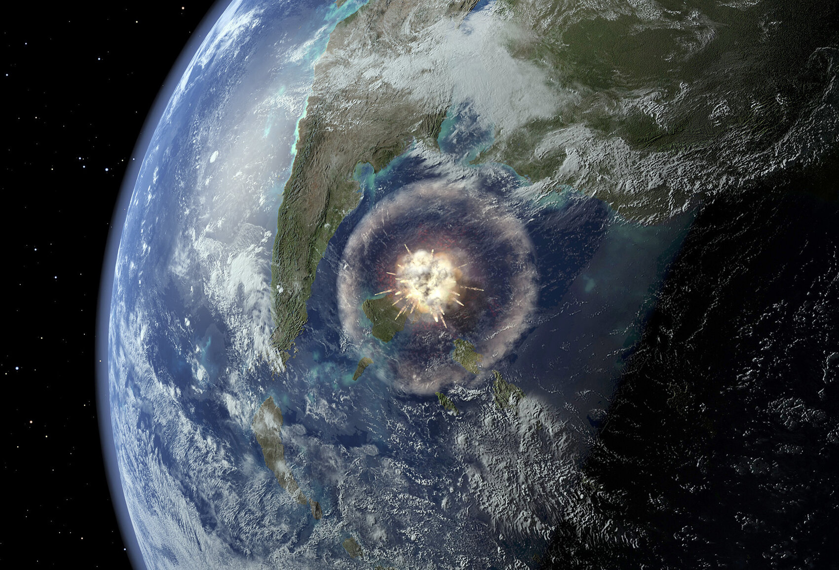
Interesting: Geologists Find Clues In Crater Left By Dinosaur-Killing Asteroid – Scientists have had a literal breakthrough off the coast of Mexico.
After weeks of drilling from an offshore platform in the Gulf of Mexico, they have reached rocks left over from the day the Earth was hit by a killer asteroid.
The cataclysm is believed to have wiped out the dinosaurs. “This was probably the most important event in the last 100 million years,” says Joanna Morgan, a geophysicist at Imperial College in London and a leader of the expedition.
Since the 1980s, researchers have known about the impact site, located near the present-day Yucatan Peninsula. Known as Chicxulub, the crater is approximately 125 miles across. It was created when an asteroid the size of Staten Island, N.Y., struck Earth around 66 million years ago. The initial explosion from the impact would have made a nuclear bomb look like a firecracker. The searing heat started wildfires many hundreds of miles away.
After that, came an unscheduled winter. Sulfur, ash and debris clouded the sky. Darkness fell and, for a while, Earth was not itself.
“I think it was a bad few months, really,” Morgan says.
That’s an understatement: Scientists believe 75 percent of life went extinct during this dark chapter in Earth’s history, including the dinosaurs.
Researchers have sampled Chicxulub before, but this expedition by the European Consortium for Ocean Research Drilling precisely targets a key part of the crater yet to be studied: a ring of mountains left by the asteroid. This “peak ring” is a fundamental feature of the strike and should tell researchers much more about it, says Sean Gulick, a geophysicist at the University of Texas at Austin, who co-leads the team with Morgan.
For weeks, they’ve been drilling — and going back in time. Each layer of rock they pass through is connected to a part of Earth’s history.
“We went through a remarkable amount of the post-impact world. All the way into the Eocene times — so between 50 and 55 million years ago,” Gulick says.
The rocks they’ve pulled out show how life began to recover after the cataclysm, Gulick says. “We’ve got all these limestones and rocks that contain the fossils from the world after the impact, all the things that evolved from the few organisms that survived.”
The research team finally reached the top of the peak ring this week. It appears to be a thick layer of broken, melted rock just beneath a layer of sandstone that may be the leavings of a huge tsunami that was triggered when the asteroid struck.
Gulick thinks the rocks hold clues. For example, if any microscopic organisms survived near the site of the strike, their fossils might be in these samples. In June, the rock cores will be sent back to a lab in Germany for further study.
The asteroid strike marked the end of an era. But the creatures that made it through that catastrophe went on to shape the world again, says Morgan.
“The mammals survived,” she says. “And that led on to our own evolution.”
Douglas MasDougal Says:
Aloha Glen
Slightly cooler! It is only 69′ here in Kapalua ….been raining all day…but we love the change ,
quite out of the ordinary for us. Thanks for the great article about the asteroid.
Regards
Douglas
~~~ Hi Douglas, cooler than normal…I agree. This was more like a winter day, than a spring day! I’ve enjoyed the change as well, and we may get some more showers before the residual moisture from this recent cold front is completely done with us.
You are welcome, that is an interesting article.
Aloha, Glenn
Richard Thompson Says:
Hi Glenn, I really miss the weather map. Are you dropping it from your narrative? Could you place a link under ‘satellite images’?
Mahalo, Richard
~~~ Hi Richard, sorry, I’ve inserted it back where it was before!
Aloha, Glenn