


Air Temperatures – The following maximum temperatures (F) were recorded across the state of Hawaii Friday…and the low temperatures Friday:
89 – 69 Lihue, Kauai
85 – 73 Honolulu, Oahu
85 – 64 Molokai AP
85 – 70 Maui
85 – 74 Kailua Kona
85 – 70 Hilo AP, Hawaii
Here are the latest 24-hour precipitation totals (inches) for each of the islands…as of Friday evening:
3.72 Kokee, Kauai
1.32 Palehua, Oahu
0.02 Molokai 1, Molokai
0.00 Lanai
0.20 Kahoolawe
0.51 Kaupo Gap, Maui
0.45 Saddle Quarry, Big Island
The following numbers represent the strongest wind gusts (mph)…as of Friday evening:
23 Mana, Kauai – N
18 Kii, Oahu – W
08 Molokai – NW
14 Lanai – NW
15 Kahoolawe – NW
14 Maalaea Bay, Maui – NNE
16 Upolu AP, Big Island – ENE
Hawaii’s Mountains – Here’s a link to the live web cam on the summit of near 13,800 foot Mauna Kea on the Big Island of Hawaii. This web cam is available during the daylight hours here in the islands…and when there’s a big moon shining down during the night at times. Plus, during the nights you will be able to see stars, and the sunrise and sunset too…depending upon weather conditions.
Aloha Paragraphs

A low pressure system over the ocean to the north-northeast…along
with its associated cold front moving into the state – moisture
is being carried towards the islands on the southeast breezes

Thunderstorms far southeast through southwest…with a cold front
sliding southeast into the state

Clear to partly cloudy, with cloudy areas locally…a cold
front has moved over Kauai onto Oahu

Showers falling locally…some moderate to locally heavy
Looping radar image
High Surf Advisory…south facing shores
Small Craft Advisory…Kauai leeward waters
~~~ Hawaii Weather Narrative ~~~
Returning trade winds during the weekend…in the wake of the frontal passage. Trade winds have briefly given way to light and variable breezes, as a cold front into the state from the northwest. As this front has gotten closer, we’ve seen our winds become lighter, which will remain this way into Saturday morning. There is a fair amount of volcanic haze in our air now, although it should be swept away during the weekend. The trade winds are slated to begin blowing again later Saturday, and remain active through all of next week.
Here’s a wind profile…of the offshore waters around the islands – with a closer view
Here’s the Hawaiian Islands Sulfate Aerosol animated graphic – showing vog forecast
A period of unsettled weather is expected…as a late season cold front makes its way down the island chain into Saturday. The models show this frontal boundary weakening as it moves into the state…likely stalling over the eastern islands later Saturday into Sunday. Then, as a northeasterly air flow arrives in the wake of this frontal passage, we’ll find shower activity continuing along the windward sides for several days…especially over Maui and the Big Island for several days into the new work week ahead.
Marine environment details: A new NNW swell is expected to build tonight and tomorrow. This swell will persist into next week as the direction shifts to the N, due to a persistent but relatively weak surface low to the distant NNE. Peak surf heights along north facing shores are expected to remain below advisory levels.
A south swell is expected to build over the next 24 hours or so, peaking this weekend near advisory levels along S facing shores. This swell has the potential to produce surf near advisory levels at it’s peak over the weekend, but confidence is currently not high enough for a high surf advisory.
High pressure building to the distant NW of the islands over the next 12 to 24 hours will push a front down the island chain, while also bringing increasing NNE winds. Winds may get strong enough to support the issuance of a small craft advisory this weekend where winds are most accelerated by island terrain. The initial area of concern would be leeward Kauai waters later tonight and Saturday, with winds increasing from NW to SE across the chain from tonight through Saturday night.

Here on Maui – Before sunrise on this Friday morning, we find clear to partly cloudy skies along the windward coasts and slopes. Elsewhere around the island, skies were mostly clear to partly cloudy…other than the volcanic haze that has spread over the island. Here in upcountry Kula, it was calm and clear, with an air temperature at my weather tower of 52.1F degrees. / Now at 1145am, its cloudy, and has started to rain here at my place in upcountry Kula. At near the same time, Kahului was reporting partly sunny skies, while it was sunny out in Hana.
– Early afternoon, with mostly cloudy skies across the island. I can see now that moderately thick volcanic haze (vog) has spread over the island too. There have been generally light, off and on showers falling locally. There were heavy rains falling out towards Kaupo through Nahiku earlier today, which necessitated a flood advisory…although that stuff has ended.
– Early evening under clear to cloudy conditions, depending upon location, with a few showers falling locally. At the same time, we have volcanic haze over us as well.
World-wide tropical cyclone activity:
>>> Atlantic Ocean: The last regularly scheduled Tropical Weather Outlook of the 2015 Atlantic hurricane season…has occurred. Routine issuance of the Tropical Weather Outlook will resume on June 1, 2016. During the off-season, Special Tropical Weather Outlooks will be issued if conditions warrant. Here’s the 2015 hurricane season summary
Here’s a satellite image of the Atlantic Ocean
>>> Caribbean Sea: The last regularly scheduled Tropical Weather Outlook of the 2015 Atlantic hurricane season…has occurred. Routine issuance of the Tropical Weather Outlook will resume on June 1, 2016. During the off-season, Special Tropical Weather Outlooks will be issued if conditions warrant.
>>> Gulf of Mexico: The last regularly scheduled Tropical Weather Outlook of the 2015 Atlantic hurricane season…has occurred. Routine issuance of the Tropical Weather Outlook will resume on June 1, 2016. During the off-season, Special Tropical Weather Outlooks will be issued if conditions warrant.
Here’s a satellite image of the Caribbean Sea…and the Gulf of Mexico
Here’s the link to the National Hurricane Center (NHC)
>>> Eastern Pacific: The last regularly scheduled Tropical Weather Outlook of the 2015 North Pacific hurricane season…has occurred. Routine issuance of the Tropical Weather Outlook will resume on May 15, 2016. During the off-season, Special Tropical Weather Outlooks will be issued if conditions warrant. Here’s the 2015 hurricane season summary
Here’s a wide satellite image that covers the entire area between Mexico, out through the central Pacific…to the International Dateline.
Here’s the link to the National Hurricane Center (NHC)
>>> Central Pacific: The central north Pacific hurricane season has officially ended. Routine issuance of the tropical weather outlook will resume on June 1, 2016. During the off-season, special tropical weather outlooks will be issued if conditions warrant. Here’s the 2015 hurricane season summary
Here’s a link to the Central Pacific Hurricane Center (CPHC)
>>> South Pacific Ocean: No active tropical cyclones
>>> North and South Indian Oceans / Arabian Sea: No active tropical cyclones
Here’s a link to the Joint Typhoon Warning Center (JTWC)
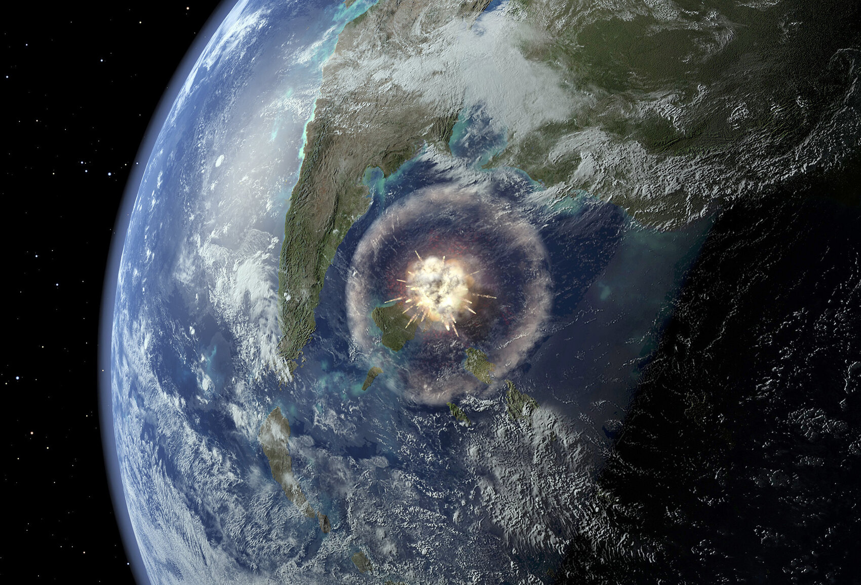
Interesting: Geologists Find Clues In Crater Left By Dinosaur-Killing Asteroid – Scientists have had a literal breakthrough off the coast of Mexico.
After weeks of drilling from an offshore platform in the Gulf of Mexico, they have reached rocks left over from the day the Earth was hit by a killer asteroid.
The cataclysm is believed to have wiped out the dinosaurs. “This was probably the most important event in the last 100 million years,” says Joanna Morgan, a geophysicist at Imperial College in London and a leader of the expedition.
Since the 1980s, researchers have known about the impact site, located near the present-day Yucatan Peninsula. Known as Chicxulub, the crater is approximately 125 miles across. It was created when an asteroid the size of Staten Island, N.Y., struck Earth around 66 million years ago. The initial explosion from the impact would have made a nuclear bomb look like a firecracker. The searing heat started wildfires many hundreds of miles away.
After that, came an unscheduled winter. Sulfur, ash and debris clouded the sky. Darkness fell and, for a while, Earth was not itself.
“I think it was a bad few months, really,” Morgan says.
That’s an understatement: Scientists believe 75 percent of life went extinct during this dark chapter in Earth’s history, including the dinosaurs.
Researchers have sampled Chicxulub before, but this expedition by the European Consortium for Ocean Research Drilling precisely targets a key part of the crater yet to be studied: a ring of mountains left by the asteroid. This “peak ring” is a fundamental feature of the strike and should tell researchers much more about it, says Sean Gulick, a geophysicist at the University of Texas at Austin, who co-leads the team with Morgan.
For weeks, they’ve been drilling — and going back in time. Each layer of rock they pass through is connected to a part of Earth’s history.
“We went through a remarkable amount of the post-impact world. All the way into the Eocene times — so between 50 and 55 million years ago,” Gulick says.
The rocks they’ve pulled out show how life began to recover after the cataclysm, Gulick says. “We’ve got all these limestones and rocks that contain the fossils from the world after the impact, all the things that evolved from the few organisms that survived.”
The research team finally reached the top of the peak ring this week. It appears to be a thick layer of broken, melted rock just beneath a layer of sandstone that may be the leavings of a huge tsunami that was triggered when the asteroid struck.
Gulick thinks the rocks hold clues. For example, if any microscopic organisms survived near the site of the strike, their fossils might be in these samples. In June, the rock cores will be sent back to a lab in Germany for further study.
The asteroid strike marked the end of an era. But the creatures that made it through that catastrophe went on to shape the world again, says Morgan.
“The mammals survived,” she says. “And that led on to our own evolution.”
Shannon Casey Says:
Tried to access Maui – Leeward/Westside weather on your site, but it would not connect to anything? broken link?
~~~ Hi Shannon, yes, there is a broken link, which connects to the National Weather Service website in Honolulu. They are unsure about when this problem will be fixed on their part. I apologize for this interruption, I’ll have it available as soon as possible.
Aloha, Glenn